

No. 6 General Report on Lands of the Alice Springs Area, Northern Territory, 1956–57
Land Research Surveys
2010(1) 1 - 300
Published: 2010
Abstract
The Alice Springs survey covered ~373,000 km2 in central Australia stretching north for 666 km from the border with South Australia and ~610 km from east to west.
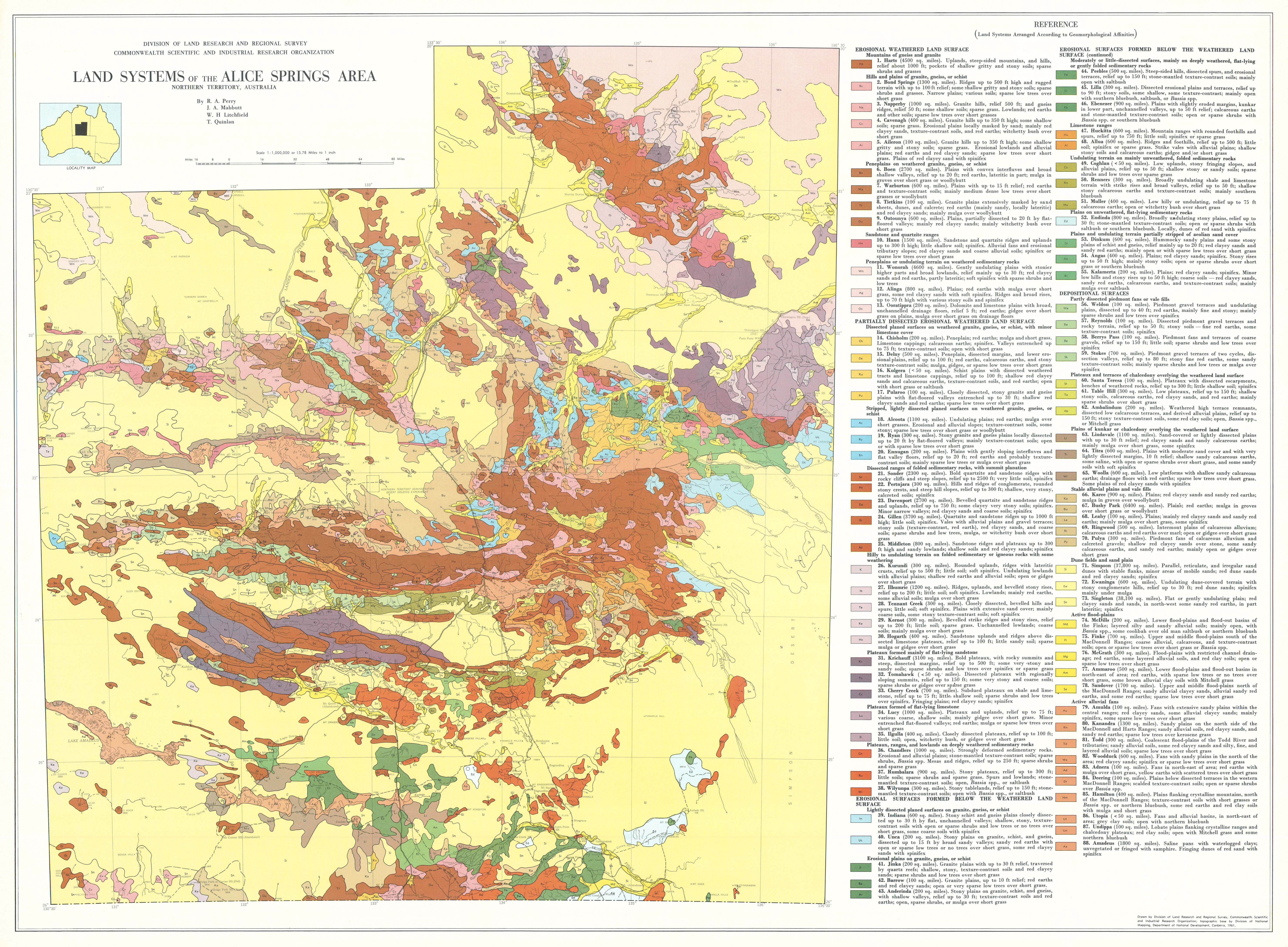
After preliminary airphoto interpretation and two field programs, more detailed mapping identified 112 types of land that were grouped into 88 land systems. Most have an area of between 260 km2 to 16,500 km2 but four small systems are less than 130 km2 and two are close to 100,000 km2.
The 88 land systems described in the report have from three to 11 land units. In all, 561 units are described in terms of their relative area, landforms, soils and plant communities and their distribution is shown on illustrative block diagrams. General descriptions are given for the location, geology and geomorphology, climate and water resources of the land systems.
Individual chapters describe:
- Climate — principal controls and general characteristics and their relation to plant growth and animal production
- Geology — lithological, structural and stratigraphic units and their influence on land systems
- Mineral Deposits — products and where they occur
- Water Resources — surface and groundwater occurrence and hydrology and irrigation resources
- Geomorphology — three broad physiographic regions (central ranges, southern desert basins and northern plains and uplands); land systems grouped into four characteristic landform classes
- Soils — frequency of eight soil groups with 42 sub-groups in relation to land systems and issues for irrigation, earthworks and soil conservation
- Vegetation — distribution of vegetation types and communities
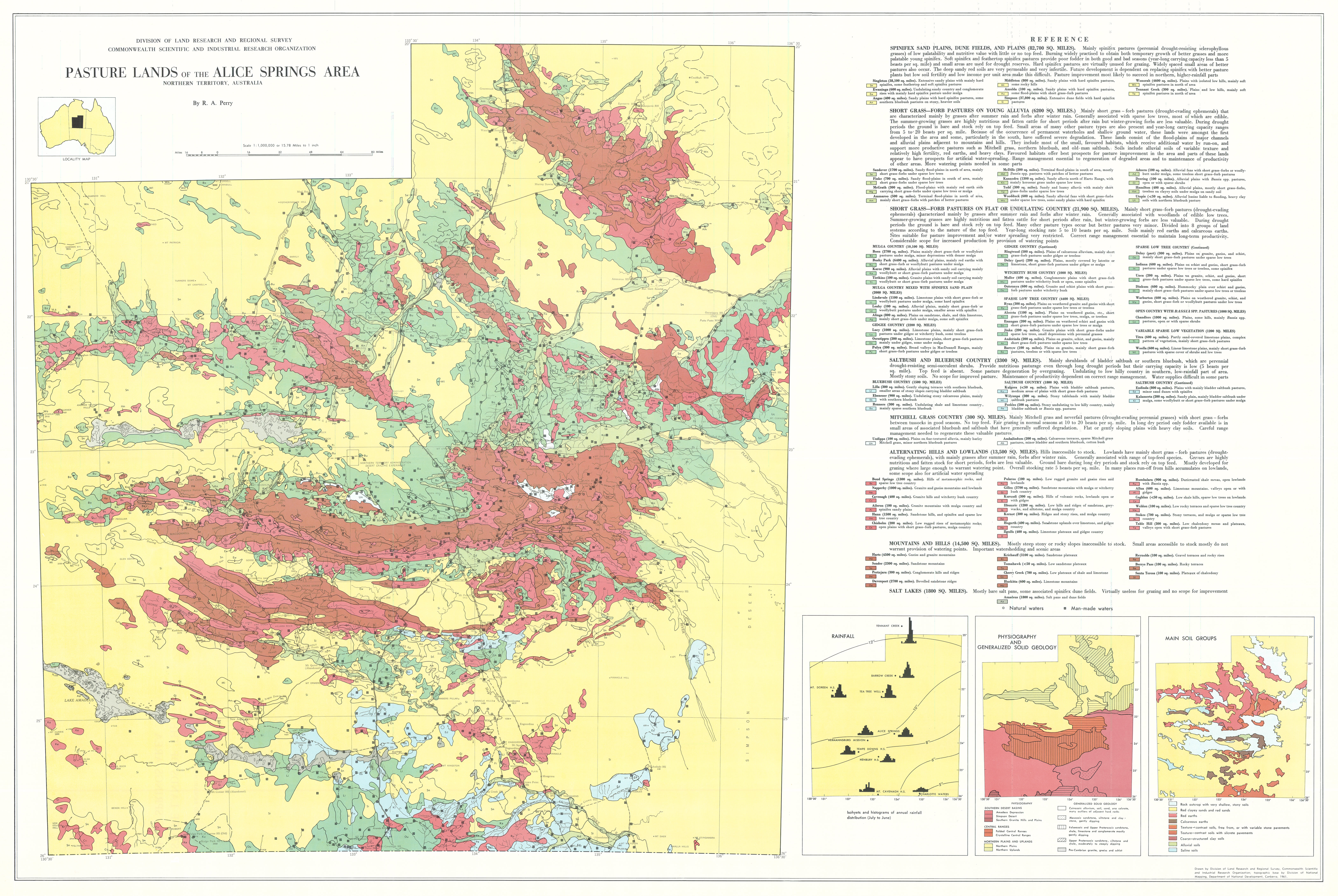
- Natural Pastures — pasture types and their recurrence in typical patterns called pasture lands
- Present and Potential Land Use — relations to climate, grazing value of pasture lands, stock water, pasture improvement and agricultural requirements.
Map 1 — Land Systems of the Alice Springs area, Northern Territory, Australia by RA Perry, JA Mabbutt, WH Litchfield and T Quinlan. Scale 1:1,000,000. CSIRO Land Research Series No. 6, 1960.
Map 2 — Geology of the Alice Springs area, Northern Territory by T Quinlin. Scale 1:1,000,000. CSIRO Land Research Series No. 6,1960.
Map 3 — Pasture Lands of the Alice Springs area, Northern Territory, Australia by RA Perry. Scale 1:1 000 000. CSIRO Land Research Series No. 6, 1960.
The maps were digitised by the Northern Territory Government with permission of CSIRO. Access to the digital files can be obtained from the NT Department of Natural Resources, Environment, the Arts and Sports.
Editor's Note: The area is now important for tourism and nature conservation as well as pastoralism. The population of Alice Springs was ~3,500 at the time of the survey and exceeds 26,000 in 2011.
https://doi.org/10.1071/LRS06
© CSIRO 2010