

No. 15 General Report on Lands of the Wabag–Tari Area, Territory of Papua and New Guinea, 1960–61
Land Research Surveys
2010(1) 1 - 150
Published: 2010
Abstract
The Wabag–Tari survey covered an area of approximately 15,940 km2 including most of Mendi Province and the central part of the Southern Highlands Province. Altitude ranges from 600 m with lowland hill forest to the summit of Mt Giluwe at 4,165 m with alpine grassland.
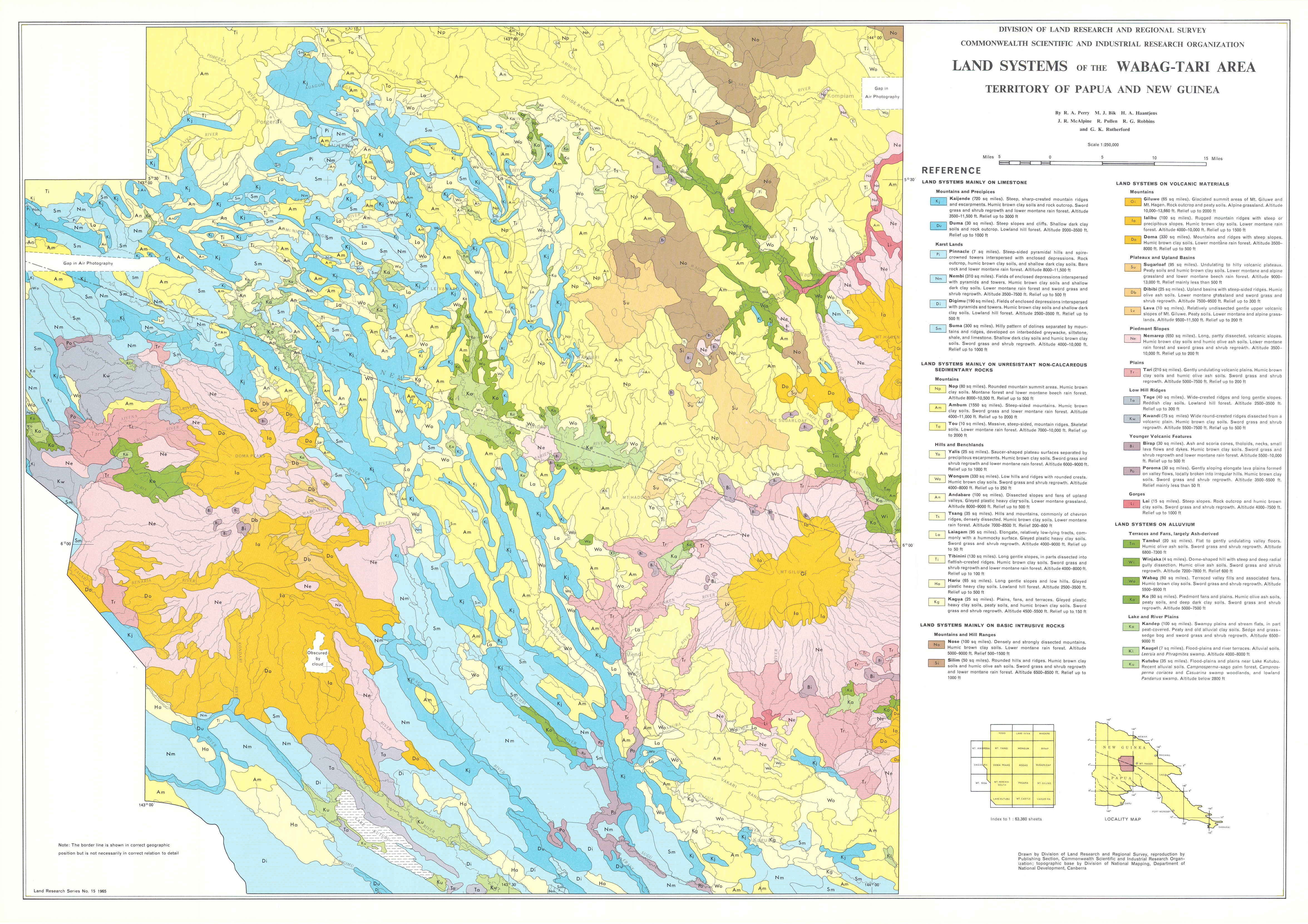
The survey established five groups of land systems distinguished by their dominant parent material – limestone, non-calcareous sedimentary rocks, basic intrusive rocks, volcanic materials and alluvium.
The survey identified 199 land units in 39 land systems ranging from 10 km2 to 4,015 km2 with between two and eight units each. The report provides general descriptions for the geology, landscape, altitude and relief, population and land use of each land system. The relative area, landform, soil, vegetation and land capability class is recorded for each land unit and their positions are shown on block diagrams.
Individual disciplinary chapters describe:
- Climate — describes climatic controls, general characteristics of the climate and its relations to plant growth and land use
- Geology and Geomorphology — outlines regional drainage features and geologic and geomorphic history, identifies three main ‘structural relief units’, and describes the relations between land systems and their geology and geomorphology
- Soils — identifies nine major soil groups and 29 soil families, shows their distribution in the land systems, and describes selected chemical and ‘granulometric’ properties
- Vegetation — recognises four broad altitudinal zones, describes features and environmental relationships of 27 plant communities within this zonal framework, and shows their distribution in the land systems
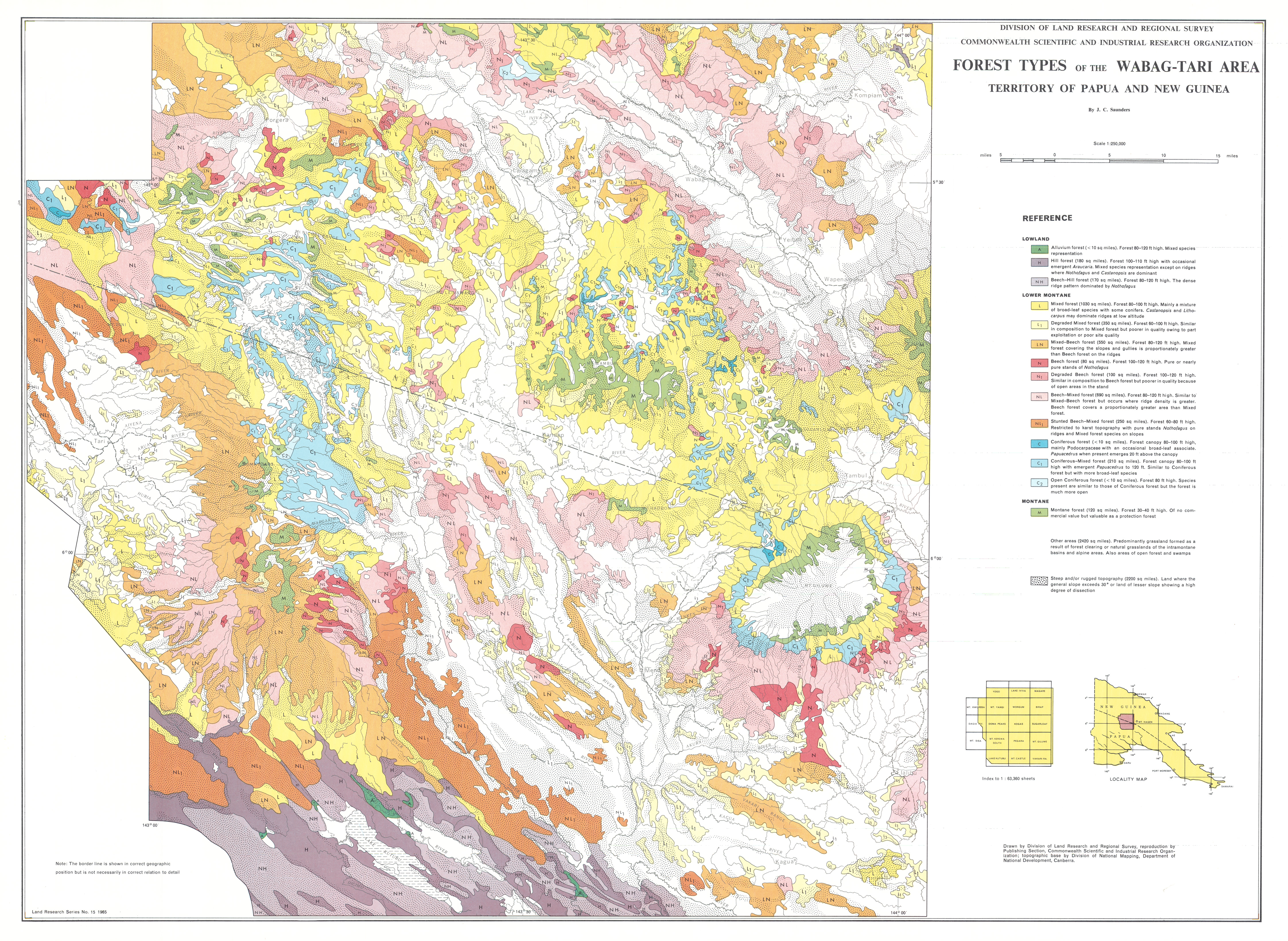
- Forest Resources — outlines survey methods and describes 14 forest types
- Population and Land Use — outlines methods and summarises population and land use information in relation to land systems
Map 1 — Land Systems of the Wabag–Tari area, Territory of Papua and New Guinea by RA Perry, MJ Bik, HA Haantjens, JR McAlpine, R Pullen, RG Robbins and GK Rutherford. Scale 1:250,000. CSIRO Land Research Series No. 15, 1965.
Map 2 — Lands of the Wabag–Tari area, Territory of Papua and New Guinea. Two maps on sheet, each scale 1:500,000: Land Capability Groups by GK Rutherford and RA Perry; Land Use Intensity by JR McAlpine. CSIRO Land Research Series No. 15, 1965.
Map 3 — Forest Types of the Wabag–Tari area, Territory of Papua and New Guinea by JC Saunders. Scale 1:250,000. CSIRO Land Research Series No. 15, 1965.
https://doi.org/10.1071/LRS15
© CSIRO 2010