

No. 25 Lands of the Adelaide–Alligator Area, Northern Territory
Land Research Surveys
2010(1) 1 - 162
Published: 2010
Abstract
The Katherine–Darwin survey and report (No. 1) recommended more detailed studies of priority areas. The Tipperary land system (No. 13) was the first and Adelaide–Alligator area survey was the second. A later survey was undertaken that included and extended this area (No. 38).
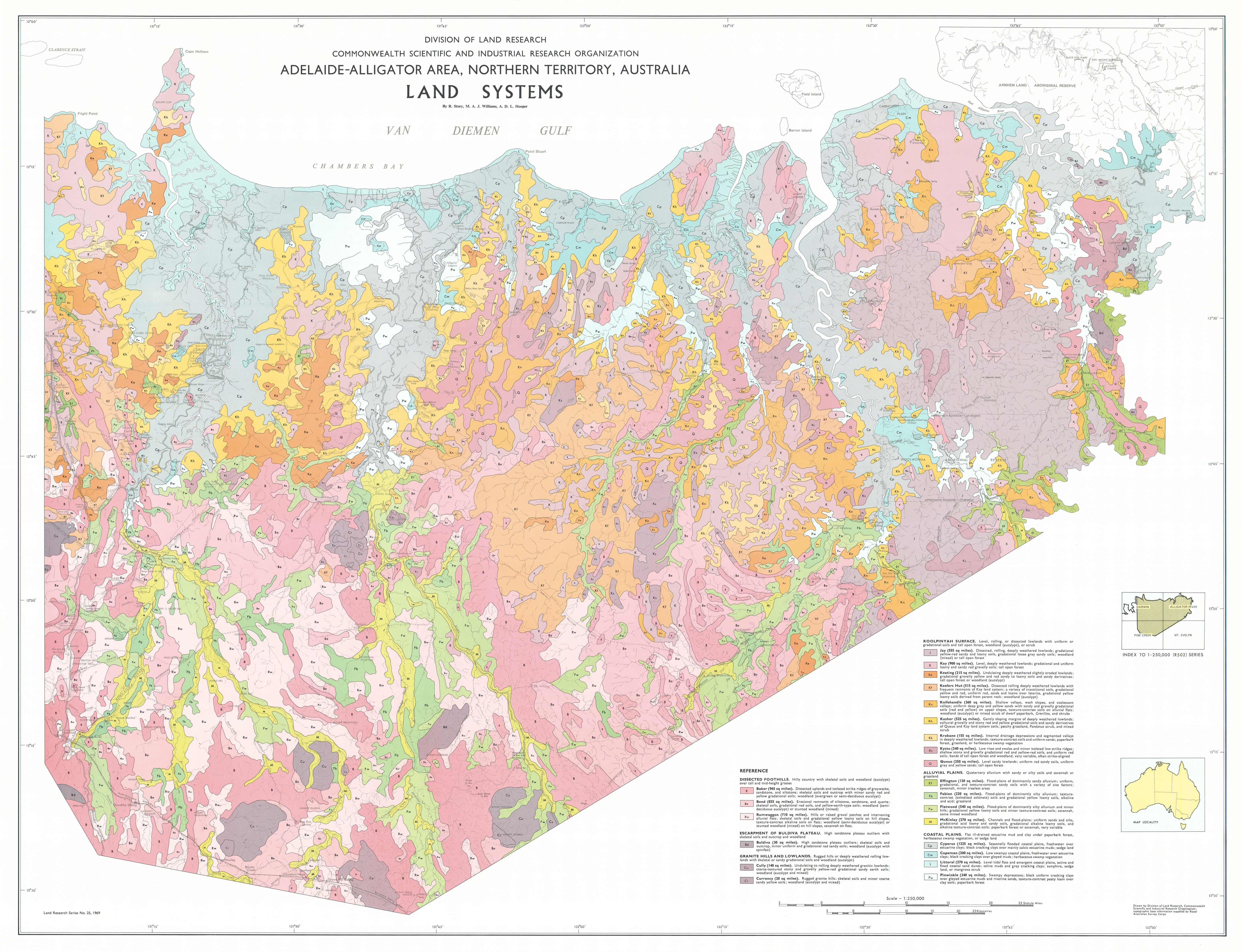
Fieldwork in the Adelaide–Alligator area was conducted in 1965, and, for the first time, used helicopters to access observation sites. The survey covered ~25,000 km2 in five major types of country. The report describes the 23 land systems ranging from 52 km2 to 3,173 km2, each with between three and six land units. The relative area and distribution, landforms, soils and vegetation of 111 land units are described and their position in the landscape shown on block diagrams.
The report has six individual disciplinary chapters:
- Climate — describes the general climatic characteristics, with an assessment of rainfall in relation to pasture growth based on a water balance model
- Geology — describes geological history, recognising six broad regions with distinctive structure and lithology
- Geomorphology — identifies six physical regions related to the geological regions, and describes land-forming processes and landscape evolution
- Soils — identifies 39 soil families in 12 major groups and describes their characteristics and distribution in a framework of four geographic zones
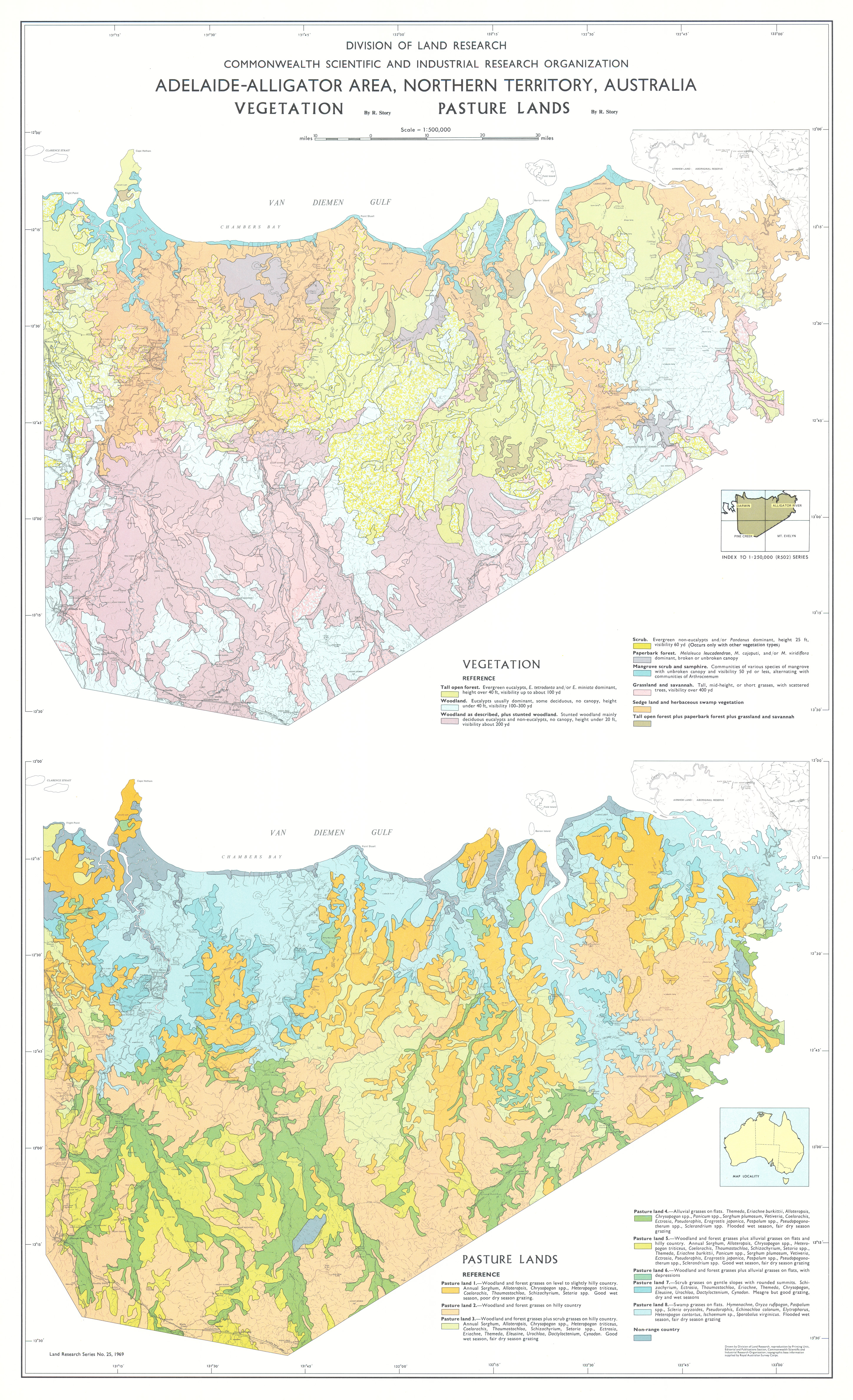
- Vegetation — describes 15 vegetation types, their area and distribution and explains the influence of climate, fire, animals, and edaphic factors
- Grasses — links topography and the grass species to describe eight types of country that have “roughly similar grazing potential”, and discusses their utilization
Map 1 — Land Systems of the Adelaide–Alligator area, Northern Territory, Australia by R Story, MAJ Williams and ADL Hooper. Scale 1:250,000. CSIRO Land Research Series No. 25, 1969.
Map 2 — Geomorphology and Soils of the Adelaide–Alligator area, Northern Territory, Australia. Two maps on sheet, each scale 1:500,000: Geomorphology by MAJ Williams; Soils by ADL Hooper. CSIRO Land Research Series No. 25, 1969.
Map 3 — Vegetation and Pasture Lands of the Adelaide–Alligator area, Northern Territory, Australia. Two maps on sheet, each scale 1:500,000: Vegetation by R Story; Pasture Lands by R Story. CSIRO Land Research Series No. 25, 1969.
The maps were digitised by the Northern Territory Government with permission of CSIRO. Access to the digital files can be obtained from the NT Department of Natural Resources, Environment, the Arts and Sports.
Editor's Note: The eastern half of the area now includes the Ranger uranium mine and part of Kakadu National Park. Prospecting had led to the Ranger uranium discovery in 1969 with mining commencing in 1980. A park was proposed in 1965 but Stage 1 was not established until 1979.
https://doi.org/10.1071/LRS25
© CSIRO 2010