

The post-fire measurement of fire severity and intensity in the Christmas 2001 Sydney wildfires
Chris J. Chafer A , Mark Noonan B and Eloys Macnaught A CA Sydney Catchment Authority, PO Box 50, Appin, NSW 2502, Australia.Telephone: +61 2 4640 1018; fax: +61 2 4640 1006; email: chris.chafer@sca.nsw.gov.au
B Sydney Catchment Authority, PO Box 323, Penrith, NSW 2751, Australia. Telephone: +61 2 4725 4727; fax: +61 2 4725 2523; email: mark.noonan@sca.nsw.gov.au
C Present address: ESRI Australia, Level 1, 414 Kent St, Sydney 2000, Australia. Telephone: +61 2 9285 5509; fax: +61 2 9267 2099; email: emacnaught@esriau.com.au
International Journal of Wildland Fire 13(2) 227-240 https://doi.org/10.1071/WF03041
Submitted: 15 April 2003 Accepted: 7 November 2003 Published: 29 June 2004
Abstract
Using pre- and post-fire satellite imagery from SPOT2, we examined the fire severity and intensity of the Christmas 2001 wildfires in the greater Sydney Basin, Australia. We computed a Normalised Difference Vegetation Index (NDVI) from the two satellite images captured before (November 2001) and after (January 2002) the wildfires, then subtracted the later from the former to produce a difference image (NDVIdiff) which was subsequently classified into six fire severity classes (unburnt, low, moderate, high, very high and extreme severity). We then tested the fire severity classification on 342 sample sites within the 225 000ha fire affected area using a qualitative visual assessment guide. We found that the NDVIdiff classification produced an accuracy of at least 88% (K hat = 0.86), with the greatest discrepancy being between the low and moderate classification. Knowledge of rate of spread over some of the affected area, coupled with a complete knowledge of fuel loads, was used to retrospectively model fire intensity, which in areas of extreme fire intensity, produced heat energy levels exceeding 70 000 kW m–1. Importantly, we found no positive effect of topography on fire severity, in fact finding an inverse relationship between slope and fire severity and no effect due to aspect. Further analysis showed that flat to moderate slopes less than 18° across all aspects suffered the greatest vegetal destruction, and there was no relationship between north-westerly aspects and fire severity. We also introduce a relatively simple method for estimating fuel load biomass using a combination of satellite image and rapid field assessment. We found 79% accuracy for this method based on 125 sample sites. It is postulated that this type of analysis can greatly improve our understanding of the spatial impact of fire, how natural areas within the fire ground were impacted, and how remote sensing and GIS technologies can be efficiently used in fire management planning and post-fire analysis.
Acknowledgements
This work was funded by the Sydney Catchment Authority. We thank Damien Carrol from SPOT Australia for rapidly processing and acquiring the imagery used in this study during the Christmas–New Year festive season. Martin Krogh provided statistical advice. We thank Paul Shanahan, Kirk Newport, Kel Lambkin, Daniel Deere and three anonymous referees for critically reviewing field work protocols and reviewing drafts of the text. Tracey Flanagan, Dennis Ashton, Brandon Haywood, Caroline Dearson and Jacki Haywood assisted in the fieldwork relating to fuel load and fire severity assessment.
Alexander ME (1982) Calculating and interpreting forest fire intensities. Canadian Journal of Botany 60, 347–359.
McCarthy GJ, Tolhurst KG, Chatto K (1999) ‘Overall fuel hazard guide.’ 3rd edn. (Department of Natural Resources and Management: East Melbourne)
Morrison DA (2002) Effects of fire intensity on plant species composition of sandstone communities in the Sydney region. Austral Ecology 27, 433–441.
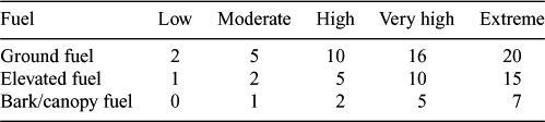
| Crossref | GoogleScholarGoogle Scholar | to 125 sample sites through the Metropolitan and Woronora Special Areas (Fig. 1), and used a modification of McCarthy et al. (1999) to estimate available total fuels in the study area (Table A1). The visual assessment method describes three fuel layers found in the field;
-
Ground fuel, all dead and decomposing vegetation in the litter bed and terrestrial herbs and grasses;
-
Elevated fuel, all shrubs, heath and suspended vegetation less than 2 mm in diameter; and
-
Bark hazard, which can propagate fire into the tree canopy.
From the above data equations (2) and (3) can be computed and spatially applied within ArcView Spatial Analyst. For the illustrated example (Fig. 9) used we assume an approximate constant rate of flat terrain spread of 4.5 km h–1 based on a recorded wind speed of 40–50 km h–1 (Winter and Watts 2002) while the fire burnt through the Woronora catchment (approximately 3 h). For example, combining equations (2) and (3), fire intensity can be computed:

and k is 0.035.
With an estimated fuel load (w) of 10–20 t ha–1 and a rate of spread r of 4.5 km h–1 (75 m min–1), slope varied between ± 35° and the average heat yield (H) is constant at 16 000 kJ kg–1 (Cheney 1981), then for a range of fuel loads (Table A2) the estimated fire intensity can be computed using equation (4). This clearly shows that, even for relatively flat terrain, very high fire intensities were to be expected in the given weather conditions.
|

|