

Verification of WRF modelled fire weather in the 2009–10 New Zealand fire season
C. C. Simpson A B C E , H. G. Pearce D , A. P. Sturman A and P. Zawar-Reza AA Centre for Atmospheric Research, University of Canterbury, Christchurch, 8140, New Zealand.
B School of Physical, Environmental and Mathematical Sciences, University of New South Wales Canberra, Canberra, ACT 2610, Australia.
C Bushfire Cooperative Research Centre, East Melbourne, Vic. 3002, Australia.
D Rural Fire Research Group, Scion, Christchurch, New Zealand.
E Corresponding author. Email: colin.c.simpson@gmail.com
International Journal of Wildland Fire 23(1) 34-45 https://doi.org/10.1071/WF12152
Submitted: 10 September 2012 Accepted: 22 July 2013 Published: 23 September 2013
Abstract
The Weather Research and Forecasting (WRF) mesoscale model was used to simulate the fire weather conditions for the 2009–10 wildland fire season in New Zealand. The suitability of WRF to simulate the high-end fire weather conditions for this period was assessed through direct comparison with observational data taken from 23 surface and two upper-air stations located across New Zealand. The weather variables and fire weather indices considered in the verification were the 1200 hours NZST air temperature, relative humidity, wind speed and direction, 24-h rainfall, New Zealand Fire Weather Index (FWI) and Continuous Haines Index (CHI). On observed high-end fire weather days, the model under-predicted the air temperatures and relative humidities, and over-predicted the wind speeds and 24-h rainfall at most weather stations. The results demonstrated that although WRF is suitable for modelling the air temperatures, there are issues with modelling the wind speeds and rainfall quantities. The model error in the wind speeds and 24-h rainfall contributed significantly towards the model under-prediction of the FWI on observed high-end fire weather days. In addition, the model was not suitable for predicting the number of high-end fire weather days at most weather stations, which represents a serious operational limitation of the WRF model for fire management applications. Finally, the modelled CHI values were only in moderate agreement with the observed values, principally due to the model error in the dew point depression at 850 hPa.
Introduction
It is widely acknowledged that the weather is an important component of the wildland fire environment, alongside the fuel characteristics and topography (Countryman 1972). The close association between wildland fire behaviour and the weather has led to the development of fire weather indices to support fire management activities. Fire weather indices summarise specific aspects of the local atmospheric conditions and typically rate the severity of fire weather conditions using a numerical scale. These indices commonly incorporate weather variables such as the air temperature, relative humidity, wind conditions, precipitation and atmospheric stability. Several fire weather indices form part of a more complete fire danger rating system. Examples include the Canadian Forest Fire Danger Rating System (CFFDRS) used in Canada (Van Wagner and Pickett 1985; Van Wagner 1987; Stocks et al. 1989), the National Fire Danger Rating System used in the United States (Deeming et al. 1977) and the McArthur Forest Fire Danger Index used in Australia (McArthur 1966, 1967).
The New Zealand Fire Danger Rating System (NZFDRS) is used operationally in New Zealand to support a range of fire management activities, including the allocation of firefighting equipment and development of fire suppression strategies (Anderson 2005). The NZFDRS is based on the CFFDRS and has been specifically modified for use in New Zealand (Alexander 1994, 2008; Fogarty et al. 1998). The New Zealand Fire Weather Index (FWI) is a key component of the NZFDRS and is the primary tool used for fire weather assessment in New Zealand. The FWI is calculated at individual weather stations located across New Zealand using near-surface weather station measurements taken at 1200 hours New Zealand Standard Time (NZST). The Haines Index (Haines 1988) is also used in a limited context operationally, although there is little understanding of how the index specifically relates to fire danger and behaviour in New Zealand. National gridded forecasts of the FWI and Haines Index are issued daily by the New Zealand MetService (NZMS) and are derived from numerical weather prediction (NWP) model output.
Previous studies on fire weather and climate in New Zealand have tended to focus specifically on the FWI and observational data collected at weather stations (Pearce 1996; Pearce et al. 2003, 2011). However, there are two main limitations to this approach. First, the weather station data are only available at uneven spatial distribution across New Zealand, particularly in mountainous regions such as the Southern Alps. This is due to the highly variable nature of weather throughout the complex terrain of New Zealand. Second, there has been limited consideration of fire weather conditions aloft, which can be important for fire behaviour, and there are few upper-air monitoring stations in New Zealand. NWP mesoscale modelling of the three-dimensional fire weather conditions could partially resolve these two issues. However, there have been no dedicated studies on the suitability of NWP modelling of fire weather in New Zealand. Oreskes et al. (1994) have previously highlighted the importance of building trust in numerical modelling through careful evaluation of its output.
Few studies have focussed on assessing NWP mesoscale modelling of fire weather conditions and indices, particularly in an operational context. Hoadley et al. (2004) investigated the suitability of the fifth-generation Pennsylvania State University–National Center for Atmospheric Research Mesoscale Model (MM5) for predicting fire weather for western Montana and northern Idaho at three different horizontal resolutions. Mölders (2008) investigated the suitability of the Weather Research and Forecasting (WRF) mesoscale model for predicting fire weather in a boreal forest environment in Alaska. Clarke et al. (2013) have assessed the simulation skill for a long-term WRF model simulation of fire weather in south-east Australia. The results presented in these studies suggest that there may be significant model errors for important fire weather variables, including the relative humidity and wind speed. This has implications for NWP modelling of the FWI, which is partially derived from these weather variables.
New Zealand has extensive areas of rural land, with 85.7% of the population living in urban areas in 2001 and considerable recent growth in the peri-urban population. Natural forest, scrubland and agricultural grasslands predominantly cover the rural land. National Rural Fire Authority data show that there were 3858 recorded wildland fires in the 2009–10 fire season, which burned a total area of 5253 ha. The Christchurch and Dunedin fire regions, both located in the eastern South Island, respectively had the greatest number of individual fires (26.7%) and total area burned (59.2%). Camp fires or rubbish fires (22.7%) and deliberately lit vegetation fires (19.5%) were the leading causes of ignition. In comparison, only 1.6% of the fires are known to have been ignited through non-anthropogenic causes, and the ignition cause of a further 16.2% of the fires is unknown. The 2009–10 fire season was reasonably representative of the average New Zealand fire season and was chosen as it was the most recent season for which a nationally consistent fire weather climatology has been developed (Pearce et al. 2011).
The principal aim of this study is to investigate the suitability of NWP mesoscale modelling of fire weather for the 2009–10 wildland fire season in New Zealand. This is achieved through a direct comparison of the NWP model output with observational data taken from weather stations located across New Zealand. The next section describes the methods used throughout this paper, and includes a description of the NWP model configuration, the fire weather indices and the model verification techniques. The model verification results and a discussion of these results are provided in the subsequent two sections. This is followed by the summary and conclusions.
Methods
Numerical weather prediction model
Version 3.2 of the WRF mesoscale model (Skamarock et al. 2008) was used to numerically simulate the fire weather conditions during the 2009–10 wildland fire season. The WRF model was chosen as it is widely used by the scientific community to model synoptic and mesoscale atmospheric processes, and is increasingly being used in New Zealand. The WRF model simulation covers the period from 0000 hours NZST on 1 July 2009 to 0000 hours NZST on 1 April 2010. The first month of the simulation in July includes the model spin-up period and is not considered in the results. The remaining 8-month period covers the 2009–10 New Zealand fire season, starting in the late austral winter. The WRF model output was taken at hourly intervals and matches the timing of weather station measurements. The air temperature and relative humidity are taken at 2 m above ground level (AGL), whereas the wind speed and direction are taken at 10 m AGL.
A two-way nested two domain configuration was used to model synoptic and mesoscale atmospheric processes over New Zealand and the adjoining Tasman Sea and Pacific Ocean. The outer and nested model domains had respective horizontal grid spacings of 24 and 8 km and computational domains of 100 × 100 and 142 × 196 grid points. The outer model domain extends far out into the Tasman Sea and Pacific Ocean, whereas the nested model domain just covers all of mainland New Zealand. The two domains share an identical configuration of 50 vertical levels, which extend from a height of ~16 m AGL to a fixed model pressure top of 50 hPa. The outer model domain was nudged at 6-hourly intervals using the National Centers for Environmental Prediction Final Analyses (NCEP FNL).
The WRF model utilises fully compressible non-hydrostatic equations and has a mass-based terrain-following coordinate system. The microphysics were represented by a single-moment six-class scheme with mixed-phase processes (Hong and Lim 2006). The sub-grid scale effects of convective or shallow clouds were modelled in the outer model domain using the modified Kain–Fritsch scheme (Kain 2004). The surface layer and planetary boundary layer were represented by the Eta schemes (Janjić 1990, 1996, 2002). The heat and moisture fluxes over land were provided by the Noah Land Surface Model (Chen and Dudhia 2001), which has soil temperature and moisture in four layers, fractional snow cover and frozen soil physics. The short-wave and long-wave radiation were respectively represented by a simple short-wave radiation scheme (Dudhia 1989) and the Rapid Radiative Transfer Model (Mlawer et al. 1997). A gravity wave damping layer (Klemp et al. 2008) was used to prevent gravity wave reflection off the upper boundary. Due to the long duration of the numerical simulation, the deep soil and sea surface temperatures were regularly updated (Zeng and Beljaars 2005), and the albedo and vegetation fractions were re-evaluated monthly. The main model time steps were respectively 60 and 20 s for the outer and nested model domains with time integration performed using a third-order Runge–Kutta scheme (Wicker and Skamarock 2002). This setup represents a fairly standard WRF model configuration for longer-term simulations such as this.
Fire weather indices
The fire weather conditions were assessed through consideration of weather variables that are known to be associated with wildland fire behaviour, including the air temperature, relative humidity and wind conditions, and fire weather indices derived from such weather variables. The fire weather indices specifically considered in this study were the New Zealand FWI and Continuous Haines Index (CHI) (Mills and McCaw 2010). The FWI is widely used operationally in New Zealand, whereas the CHI is currently under consideration for operational implementation in the near future.
The FWI is a fire behaviour index that indicates the expected wildland fire intensity for a reference fuel type, although it is also commonly used as an indicator of fire danger (Lawson and Armitage 2008). The FWI is derived from two intermediate fire behaviour indices, known as the Initial Spread Index (ISI) and Build Up Index (BUI). The ISI and BUI respectively indicate the expected rate of fire spread and the availability of fuel for combustion. The ISI is derived from the wind speed at 1200 hours NZST and the Fine Fuel Moisture Code (FFMC), whereas the BUI is derived from the Duff Moisture Code (DMC) and Drought Code (DC). The FFMC, DMC and DC are fuel moisture indices that are calculated once daily based on the near-surface air temperature, relative humidity, wind speed and 24-h rainfall at 1200 hours NZST. They are each calculated iteratively, such that their value on a given day is directly dependent on the previous day’s value. The FFMC represents the ease of ignition and flammability of fine fuels, the DMC represents the expected fuel consumption in duff layers and moderately sized fuels, and the DC represents the seasonal drought effect on deep organic layers and large sized fuels.
This system of indices collectively accounts for the effect of near-surface fire weather conditions on the fuel moisture and potential fire behaviour. The FWI is typically ~5–15 across most of New Zealand, although it can be close to 0 after significant precipitation and can exceed 80 under extreme fire weather conditions (Pearce et al. 2011). Four fire danger classes, which are determined directly from the FWI, have been developed for use in forested regions in New Zealand (Alexander 1994, 2008). These fire danger classes are: ‘Low’ (0–7), ‘Moderate’ (8–16), ‘High’ (17–31) and ‘Extreme’ (32+). Other classifications are used for scrub and grass fuel types, but are not considered in this study.
The CHI is a stand-alone fire weather index that is based on the widely used Haines Index (Haines 1988) and provides a combined measure of the instantaneous atmospheric stability and humidity aloft. The atmospheric stability index is calculated from the air temperature difference between 850 and 700 hPa, and the humidity index is calculated from the dew point depression at 850 hPa. More unstable atmospheric conditions (which result in a higher air temperature lapse rate) and drier atmospheric conditions (which result in a higher dew point depression) both result in higher CHI values. The CHI is mathematically limited to a minimum value of 0 and does not typically exceed values of 12–14 in southern Australia. The CHI is considered instead of the Haines Index due to its wider numerical range, which offers greater determination of fire weather severity.
Model verification
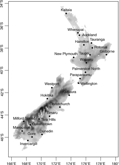
Fig. 1 shows the geographical location of the 25 weather stations used in the model verification. This includes 23 stations with near-surface observations suitable for deriving the FWI, and two stations (Whenupai and Paraparaumu) with upper-air observations suitable for deriving the CHI. The 23 surface stations collectively represent most of the main fire climate regions of New Zealand (NZMS 1983) and are located at a mix of coastal and inland locations. The near-surface data include 1200 hours NZST observations of the air temperature and relative humidity at 1.2 m AGL, wind speed and direction at 10 m AGL, and 24-h rainfall. The two upper-air stations are the only sites in New Zealand with regularly available 1200 hours NZST observations of the air and dew point temperatures at 850 and 700 hPa for the period of interest. Most of the weather stations are operated either by the NZMS or the National Institute of Water and Atmospheric Research (NIWA).
|
Weather station data were obtained from the National Climate Database (NCD), which is maintained by NIWA, and the fire weather climatology (FWC) developed by Pearce (1996) and Pearce et al. (2003, 2011). The NCD data are available hourly with one decimal point precision, whereas the FWC data are available once daily at 1200 hours NZST with integer precision. The NCD data are primarily used in the model verification, although there are some missing observations, which typically occur in groupings of a few hours and are likely due to equipment faults. The FWC data are used to initialise the FFMC, DMC and DC values on 31 July 2009, and are used in place of missing NCD data. Across the 23 surface weather stations, the FWC data are used in place of the missing NCD data on 27, 29, 29 and 33 instances for the air temperature, relative humidity, wind speed and wind direction.
In order to assess the model accuracy, a nearest neighbour algorithm is used to match each weather station to its nearest WRF model grid cell over land. No interpolation of the WRF model output is required as each model grid cell represents the average atmospheric conditions across it (Pielke 2002). However, there are limitations to this approach that can result in large apparent model errors at specific locations (White et al. 1999; Davis and Carr 2000; Mass et al. 2002). For example, small errors in the timing and spacing of otherwise accurately modelled weather features can result in large apparent model errors if the weather conditions vary considerably over short distances.
The weather variables and fire weather indices specifically considered in the model verification are the air temperature, relative humidity, wind speed and direction, 24-h rainfall, FWI and CHI. These variables are all assessed at 1200 hours NZST, as this represents the time of greatest relevance to fire management operations in New Zealand. The first step in the model verification involves determining the observed and modelled daily FWI values and fire danger classes (Low, Moderate, High and Extreme) at the 23 surface weather stations. A set of verification statistics is calculated for the air temperature, relative humidity, wind speed, 24-h rainfall and FWI at the 15 weather stations that have ten or more observed high-end fire weather days (High or Extreme fire danger class). The verification statistics are calculated only for those observed high-end fire weather days and include the number of days (N), mean of observed values (O), mean of modelled values (M), standard deviation of observed values (SO), standard deviation of modelled values (SM), mean bias error (MBE), mean absolute error (MAE) and index of agreement (IOA) (Willmott 1981; Jolliffe and Stephenson 2003). The IOA was developed as a measure of the relative agreement between modelled and observed data. It is defined between 0 and 1, with 0 representing no agreement and 1 representing complete agreement. For the wind direction, the model output and weather station data are compared visually using wind roses.
An additional set of five verification statistics are calculated for the 24-h rainfall. The 24-h rainfall is given a binary value based on a rainfall threshold of 0.5 mm, which is the minimum quantity required to directly influence the FWI. The binary values are used to assign one of four classifications to each day: ‘hit’, ‘false alarm’, ‘miss’ or ‘correct rejection’. These four binary classifications are then used to determine the following statistics: observed rate (OR), modelled rate (MR), hit rate (HR), false alarm rate (FR) and percentage correct (PC) (Jolliffe and Stephenson 2003).
An additional set of four IOA values are calculated for the FWI, based on independent substitution of the observed 1200 hours NZST air temperature (IOAT), relative humidity (IOAH), wind speed (IOAW) and 24-h rainfall (IOAR). Direct comparison of these IOA values indicates the relative importance of the model error in each individual weather variable for the model error in the FWI.
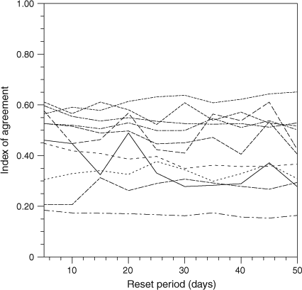
As the FWI is derived from the FFMC, DMC and DC, which are calculated iteratively each day, it is possible for the model error in the FWI to accumulate over daily and longer timescales. The importance of this model error accumulation is investigated through resetting the modelled FFMC, DMC and DC values with corresponding observed values at specific intervals. The reset period is varied from 5 to 50 days, inclusive, in steps of 5 days and the IOA statistic is calculated at the 15 weather stations for each reset period considered. If the IOA values decrease significantly with increasing reset period, this would indicate that model error accumulation over monthly to seasonal timescales is important for the FWI.
A similar methodology to that used to assess the modelled FWI is used to evaluate the modelled CHI at the Whenupai and Paraparaumu upper-air stations. The verification statistics are calculated for days where the observed CHI is ≥5, which represents the upper end of the index scale in terms of probability. The IOA is then re-calculated at both stations for independent substitution of the observed air temperature difference between 850 and 700 hPa, and the dew point depression at 850 hPa.
Results
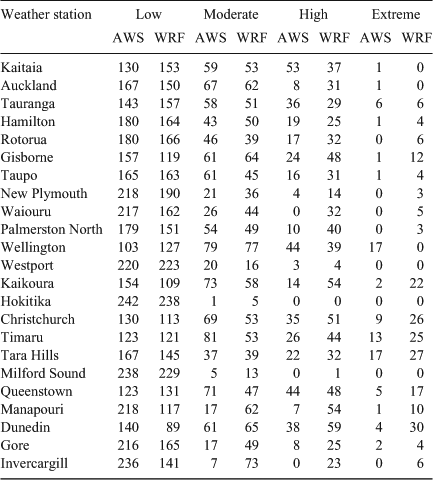
The numbers of observed and modelled days in each fire danger class at the 23 surface weather stations are presented in Table 1. At each station the Low class occurs most frequently, although the number of modelled and observed days within this class varies considerably across the stations. There are observed High or Extreme class days at 19 stations, although there are only 15 stations for which the number of days is at least equal to 10. These are the same 15 stations at which the verification statistics are calculated for the weather variables and FWI. The Wellington and Tara Hills stations have the highest number of observed Extreme class days, with 17 each. The number of modelled Extreme class days is higher than that observed at 16 stations, with the highest over-prediction at stations located in the eastern South Island, including Kaikoura, Christchurch and Dunedin.
|
The frequency distributions of the observed and modelled fire danger classes at the Wellington and Tara Hills stations are shown in Fig. 2. At Wellington the number of modelled Extreme class days is 0, compared with 17 observed days. Wellington is the only station at which the model under-predicts the number of observed Extreme days by >1 day. This represents a considerable shift of the modelled frequency distribution towards lower values relative to the observed distribution. At Tara Hills the model under-predicts the number of observed Low days by 22 days and over-predicts the number of High and Extreme days by 10 days each. This represents a considerable shift of the modelled frequency distribution towards higher values relative to the observed distribution. The results presented in Table 1 indicate that at most stations the modelled probability distribution is shifted rightwards towards higher values relative to the observed probability distribution.

|
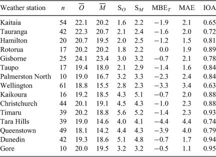
The verification statistics calculated for the air temperature on observed high-end fire weather days are presented in Table 2. The mean observed air temperature ranges from a minimum of 18.1°C at Queenstown to a maximum of 24.1°C at Gisborne. In contrast, the mean modelled air temperatures vary more widely, from a minimum of 14.2°C at Queenstown to a maximum of 23.4°C at Gisborne. The MBE is negative at each station aside from Rotorua, where it is 0°C. The MBE is most negative at Wellington, Queenstown and Tara Hills, and the MAE is also highest at these same stations. The MAE is considerably lower at the other 12 stations, varying from 1.1 to 2.4°C. The IOA is greater than 0.80 at nine stations, indicating a good level of agreement, and has a minimum of 0.63 and 0.65 at Wellington and Kaitaia.
|
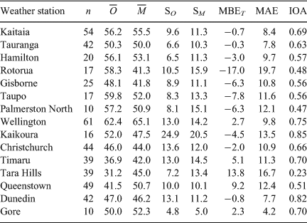
The verification statistics calculated for the relative humidity on the observed high-end fire weather days are presented in Table 3. The mean observed relative humidities range from a minimum of 31.2% at Tara Hills to a maximum of 62.4% at Wellington. In comparison, the mean modelled relative humidity ranges from a minimum of 41.3% at Rotorua to 65.1% at Wellington. The standard deviations of the modelled relative humidities are higher than those observed at 12 stations, often by a significant margin at stations located in the North Island. The MBE is negative at 10 stations and is lowest at Rotorua, where it is –17.0%. In comparison, the MBE is highest at Queenstown (9.2%) and Tara Hills (13.8%). The MAE ranges from a minimum of 4.2% at Gore to a maximum of 19.7% at Rotorua. In contrast to the air temperature, the IOA is only greater than 0.80 at Kaikoura and Dunedin, and is lower than 0.60 at seven stations, indicating only a moderate level of agreement.
|
The verification statistics calculated for the 24-h rainfall on observed high-end fire weather days are presented in Table 4. The mean observed 24-h rainfall is low at each station, ranging from a minimum of 0.01 mm at Christchurch to a maximum of 0.22 and 0.24 mm at Dunedin and Kaikoura. In contrast, the mean modelled 24-h rainfall is typically significantly higher than that observed, and ranges from a minimum of 0.11 mm at Rotorua and Tauranga, to a maximum of 1.03 and 1.07 mm at Kaikoura and Dunedin. The MBE is positive at each station and is ≥0.20 mm at 12 stations. Similarly, the MR is greater than the OR at each station, and the OR is 0 at Hamilton, Palmerston North and Christchurch, resulting in an undefined HR. Unlike the HR and FR, which vary significantly across the 15 stations, the PC is relatively consistent and ranges from a minimum of 69% at Kaikoura to a maximum of 94% at Rotorua.

|
The verification statistics calculated for the wind speed on observed high-end fire weather days are presented in Table 5. The mean observed and modelled wind speeds are both highly variable, ranging from a minimum of 21.3 and 22.9 km h–1 at Hamilton and Kaitaia to a maximum of 45.5 and 50.0 km h–1 at Gore. The standard deviations of the observed and modelled wind speeds are typically higher at the stations located in the South Island, including at Kaikoura, Timaru and Tara Hills. The MBE is positive at 12 stations and is greater than or equal to 8.5 km h–1 at five stations located in the southern and eastern South Island. In contrast, at Wellington the mean observed wind speed is high, with a value of 38.7 km h–1, and the MBE is the most negative, with a value of –5.0 km h–1. The IOA ranges from a minimum of 0.50 at Christchurch to a maximum of 0.79 at Kaitaia, Rotorua and Taupo, and is higher than 0.70 at eight stations.
|
The observed and modelled wind roses for observed high-end fire weather days are shown in Fig. 3. The most frequently observed and modelled wind directions are south-westerly, westerly and north-westerly. The exceptions are Wellington, where the most frequent observed and modelled wind direction is northerly, and Christchurch, where the most frequent observed wind direction is north-easterly. The most frequently observed and modelled wind directions match at seven of the eight North Island stations, and only at Gore in the South Island.

|
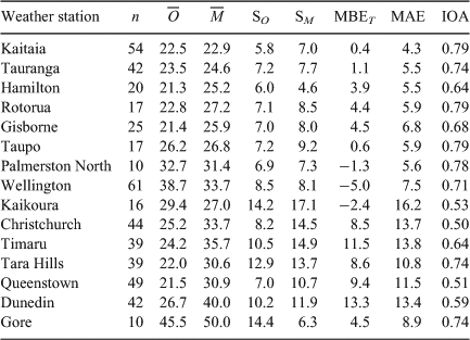
The verification statistics calculated for the FWI on observed high-end fire weather days are presented in Table 6. The mean observed FWI varies from a minimum of 19.2 at Rotorua, where there are 17 and 0 observed High and Extreme days to a maximum of 31.7 at Tara Hills, where there are 22 and 17 observed High and Extreme days. The MBE is negative at 12 stations and is lower than –7.0 at 8 stations, 6 of which are located in the North Island. The MAE is high at each station, ranging from a minimum of 8.3 and 8.6 at Palmerston North and Gore to a maximum of 17.2 and 18.4 at Rotorua and Timaru. The standard deviation of the modelled FWI tended to be considerably higher than that of the observed FWI, and is lower only at Wellington. The IOA varies significantly and ranges from a minimum of 0.16 and 0.19 at Gisborne and Hamilton to a maximum of 0.55 and 0.63 at Wellington and Christchurch.

|
Substitution of the observed air temperatures typically results in limited improvement in the IOA and even results in a decreased IOA at eight stations. Substitution of the observed relative humidities, wind speeds and 24-h rainfall results in the greatest improvement in the IOA at three, seven and six weather stations respectively. At Tara Hills, substitution of the observed relative humidities and 24-h rainfall both independently result in an improvement in the IOA from 0.51 to 0.66. At Rotorua there is no improvement in the IOA from its original value of 0.26 through independent substitution of the four observed weather variables.
Fig. 4 shows the variation of the IOA, calculated for the FWI on observed high-end fire weather days, with reset period at the 15 weather stations. At most stations there is a slight downward trend in the IOA with increasing reset period. However, the absolute change in the IOA between a reset period of 5 and 50 days is typically small. For three stations the IOA is higher for a reset period of 50 days than for 5 days. At several stations there is considerable variability in the IOA with varying reset period.
|
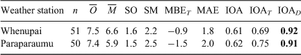
The verification statistics calculated for the CHI on days with an observed CHI >5 are presented in Table 7. The numbers of days that fall within this high-end range represent ~21% of all fire season days at both stations. On those days, the model typically under-predicts the observed CHI, as demonstrated by the negative MBE values of –0.9 and –1.5 at Whenupai and Paraparaumu. The IOA values of 0.61 and 0.62 at Whenupai and Paraparaumu indicate only a moderate level of agreement between the observed and modelled CHI. Substitution of the observed air temperature difference between 850 and 700 hPa results in only a moderate improvement in the IOA, whereas substitution of the observed dew point depression at 850 hPa results in a considerable improvement in the IOA to 0.92 and 0.91 at Whenupai and Paraparaumu.
|
Fig. 5 shows the frequency distributions of the observed and modelled CHI at Whenupai and Paraparaumu. The frequency distributions of the observed CHI are broadly similar at both stations and there are 28 and 31 days with a CHI value of 0 at Whenupai and Paraparaumu respectively. The model significantly under-predicts the number of days with a 0 CHI value at both stations. At both stations the modelled and observed CHI values do not exceed a value of 12 and are >5 on ~20% of days. At both stations, the model slightly over-predicts the number of days with a CHI value exceeding 5.

|
Discussion
On average, the model under-predicted the air temperatures on the observed high-end fire weather days. However, this cold bias had only a limited effect on the assessed accuracy of the modelled FWI. The air temperature was arguably the most accurately modelled of the four weather variables considered across New Zealand. In addition, the model also under-predicted the relative humidities at most North Island weather stations on the observed high-end fire weather days. In comparison with the air temperatures, the model error in the relative humidities had a more notable effect on the accuracy of the modelled FWI. Although not specifically tested, the model bias in the air temperatures and relative humidities could be related to biases in the NCEP FNL, which are used to nudge the outer model domain.
The characteristics of the model error in the air temperatures and relative humidities are somewhat unique at Queenstown and Tara Hills compared to the other stations. The MBE was the most negative at Queenstown and Tara Hills for the air temperature. The MBE was the most positive at Queenstown and Tara Hills for the relative humidity. The Queenstown and Tara Hills stations are located inland in fairly rugged (i.e. more mountainous) terrain, where the weather station surface elevation is considerably lower than the corresponding WRF model grid cell surface elevation. The height difference is 260 and 196 m at Queenstown and Tara Hills compared with a height difference of less than 80 m at the other stations. If the air temperature lapse rate were a constant 6.5°C km–1, then the MBE at Queenstown and Tara Hills because of the height difference alone would be –1.7 and –1.3°C. The height difference therefore likely accounts for a significant fraction of the model error in the air temperatures and relative humidities at Queenstown and Tara Hills.
The wind conditions on the observed high-end fire weather days were arguably least accurately modelled at Kaikoura, Christchurch, Timaru, Queenstown and Dunedin. Queenstown is located inland in relatively complex terrain, whereas the other stations are located in comparatively flat terrain near complex coastlines. It is unclear if the model error at these stations is mainly associated with the coarse model representation of the terrain and coastline, or the modelled atmospheric processes that affect local wind conditions on high-end fire weather days in the southern and eastern South Island. For example, the Kaikoura station is located on a peninsula that extends ~5 km into the Pacific Ocean and is therefore too small to be represented in the relatively coarse model terrain.
The most frequent modelled wind direction at Christchurch was north-westerly, which is associated with a north-westerly foehn wind known locally as the ‘Canterbury Northwester’. These foehn winds can bring high air temperatures and wind speeds, and low wind speeds to the eastern South Island, particularly near Christchurch. In contrast, the most frequent observed wind direction at Christchurch was north-easterly, which is not typically associated with these north-westerly foehn winds. It is possible that the model over-predicted the occurrence of north-westerly foehn winds at Christchurch, and possibly also Kaikoura. This could also explain the marked model over-prediction of the number of modelled Extreme fire danger class days in the eastern South Island, particularly at Christchurch, Kaikoura, Timaru and Dunedin, which can all be affected by foehn winds.
On average, the model over-predicted the number of High and Extreme fire danger class days at most weather stations, particularly in the eastern South Island. The main exception to this was at Wellington, where there were 17 and 0 observed and modelled Extreme days. The observed weather variables imply that the high wind speeds are predominantly responsible for the large number of observed high-end fire weather variables at Wellington. However, the model under-predicted the wind speeds at Wellington by 5.0 km h–1 on average, suggesting that the model under-prediction of the wind speeds at 1200 hours NZST was mainly responsible for the model’s inability to accurately capture the Extreme class days at Wellington.
Somewhat counter-intuitively, the model under-predicted the FWI on the observed high-end fire weather days at most weather stations, in addition to over-predicting the number of high-end fire weather days. This result indicates that the model must over-predict the FWI on observed Low or Moderate class days at most weather stations. The model under-prediction of the FWI on observed high-end fire weather days seems to be mainly associated with the considerable model over-prediction of the 24-h rainfall at each weather station. In contrast, the model under-prediction of the relative humidities and over-prediction of the wind speeds would act to over-predict the FWI. The lack of a downward trend of the IOA calculated for the FWI with varying reset period at most weather stations suggests that there is only limited model error accumulation in the fuel moisture and fire behaviour indices.
Similarly to the FWI, on average the model under-predicted the CHI on days with a high observed CHI, but over-predicted the number of days with a high observed CHI. For the limited sample of two stations considered, the modelled CHI was only in moderate agreement with the observed values, and the model error was mainly associated with the model error in the dew point depression at 850 hPa. The CHI is likely to exhibit considerable spatial variability across New Zealand, particularly near the mountainous terrain of the Southern Alps, and it is unclear if these specific model errors will apply across New Zealand.
Summary and conclusions
This study has investigated the suitability of the WRF mesoscale NWP model to simulate fire weather during the 2009–10 New Zealand wildland fire season. The weather variables and fire weather indices considered in the model verification were the 1200 hours NZST air temperature, relative humidity, wind speed and direction, 24-h rainfall, FWI and CHI. The WRF model was verified through direct comparison with weather station data taken from 23 surface and two upper-air monitoring stations. The analysis concentrated on those days where the FWI and CHI, derived from observational data, were high.
The errors in the WRF-modelled FWI and the subsequently derived fire danger classes varied spatially across New Zealand. For example, the WRF model substantially over-predicted the number of High and Extreme fire danger class days in the eastern South Island and did not predict a single one of the 17 Extreme class days at Wellington in the southern North Island. This implies that local terrain effects on mesoscale atmospheric processes, particularly the development of north-westerly foehn winds in the eastern South Island, were a key contributing factor in the model errors at some stations. The considerable discrepancies between the modelled and observed FWI represent a critical operational limitation of using the WRF mesoscale atmospheric model to predict FWI-based fire danger classes in some specific regions of New Zealand. Further examination of other NWP mesoscale models, particularly those that currently are used operationally to support fire management in New Zealand, is required to ascertain their operational limitations for predicting both the fire danger classes and FWI.
The WRF model over-predicted the number of days with a CHI value of 5 or higher at the two available upper-air stations. This bias was principally due to model error in the dew point depression at 850 hPa, rather than the air temperature difference between 850 and 700 hPa. However, without a more widespread network of upper-air stations recording the aloft air and dew point temperatures daily at 1200 hours NZST, NWP mesoscale modelling is required to predict either the Haines Index or CHI across most of New Zealand. Further research is therefore needed to ascertain how accurately the WRF model can predict the Haines Index or CHI across the rest of New Zealand in response to different weather patterns and varying terrain. This would require greatly extending the current network of upper-air stations to include other regions of New Zealand.
The WRF model tended to under-predict the observed air temperatures and relative humidities across New Zealand. Future work will examine in detail the contribution of biases in the NCEP FNL to this WRF model under-prediction. If the NCEP FNL are found to be unsuitable for use in New Zealand, the ERA-Interim reanalyses (Dee et al. 2011) will be tested to examine its suitability. Future work will also examine if a different set of parameterisations representing the microphysics and convective or shallow clouds are more suitable for accurately predicting rainfall quantities >0.5 mm across New Zealand. A new scheme for modifying wind speeds in or near complex terrain (Jiménez and Dudhia 2012) will also be examined in future work to determine what improvement, if any, it makes to the WRF-modelled wind conditions across New Zealand.
The results presented in this study have clearly demonstrated that, as has been found in other geographical regions (Hoadley et al. 2004; Mölders 2008, Clarke et al. 2013), there are several key issues with NWP modelling of fire weather in New Zealand. It remains unclear what benefits NWP modelling of fire weather and climate in New Zealand offers over other methods, such as interpolation of weather station data (Pearce 1996; Pearce et al. 2003, 2011). In both cases it is difficult to accurately ascertain fire weather conditions in and around complex terrain. This could be more comprehensively tested through a direct comparison of NWP model output with the NIWA ‘virtual climate station network’, which offers 5 × 5-km gridded interpolated observational data across New Zealand daily at 0900 hours NZST. However, a method would need to be devised for training the 0900 hours NZST data to determine accurate estimates of the four weather variables at 1200 NZST used to derive the FW.
Computational limitations prevented use of the WRF model with a horizontal grid spacing of <8 km in this study. Increasing the WRF model horizontal and vertical resolutions in future work offers another method of improving the accuracy of the WRF-modelled fire weather. The improved resolution of the complex terrain, coastline and land use in particular could lead to considerable improvements in the modelled wind conditions and precipitation. Finally, the NWP model used operationally by the NZMS to provide 5-day forecasts of the FWI across New Zealand will be tested and compared with the WRF model output at an identical horizontal grid spacing and with a similar model setup in future work.
Acknowledgements
This research was undertaken as part of a doctoral thesis funded by the Bushfire Cooperative Research Centre, Melbourne, Australia. The NCEP FNL were obtained from the Computational Information Systems Laboratory Research Data Archive, which is maintained by the Data Support Section of the National Center for Atmospheric Research. We also acknowledge Jason Evans (University of New South Wales, Sydney, Australia), Brian Potter (USDA Forest Service, Seattle, USA), Joseph Charney (USDA Forest Service, East Lansing, USA) and Stuart Anderson (New Zealand Ministry for Primary Industries) for useful discussions relating to this work.
References
Alexander ME (1994) Proposed revision of fire danger class criteria for forest and rural areas in New Zealand. National Rural Fire Authority, in association with the New Zealand Forest Research Institute. (Wellington)Alexander ME (2008) Proposed revision of fire danger class criteria for forest and rural areas in New Zealand, 2nd edn. National Rural Fire Authority, in association with the Scion Rural Fire Research Group. (Wellington)
Anderson S (2005) Forest and rural fire danger rating in New Zealand. In ‘Forestry Handbook’. (Ed. M Colley) pp. 241–244. (New Zealand Institute of Forestry: Christchurch)
Chen F, Dudhia J (2001) Coupling an advanced land-surface/hydrology model with the Penn State/NCAR MM5 modeling system. Part I. Model description and implementation. Monthly Weather Review 129, 569–585.
| Coupling an advanced land-surface/hydrology model with the Penn State/NCAR MM5 modeling system. Part I. Model description and implementation.Crossref | GoogleScholarGoogle Scholar |
Clarke H, Evans JP, Andrew JP (2013) Fire weather simulation skill by the Weather Research and Forecasting (WRF) model over south-east Australia from 1985 to 2009. International Journal of Wildland Fire 22, 739–756.
| Fire weather simulation skill by the Weather Research and Forecasting (WRF) model over south-east Australia from 1985 to 2009.Crossref | GoogleScholarGoogle Scholar |
Countryman CM (1972) The fire environment concept. USDA Forest Service, Pacific Southwest Forest and Range Experiment Station, Technical Paper. (Berkeley, CA) Available at http://www.firemodels.org/downloads/behaveplus/publications/Countryman/Countryman_1972_TheFireEnvironmentConcept_ocr.pdf [Verified 6 September 2013]
Davis C, Carr F (2000) Summary of the 1998 workshop on mesoscale model verification. Bulletin of the American Meteorological Society 81, 809–819.
Dee DP, Uppala SM, Simmons AJ, Berrisford P, Poli P, Kobayashi S, Andrae U, Balmaseda MA, Balsamo G, Bauer P, Bechtold P, Beljaars ACM, van de Berg L, Bidlot J, Bormann N, Delsol C, Dragani R, Fuentes M, Geer AJ, Haimberger L, Healy SB, Hersbach H, Hólm EV, Isaksen L, Kållberg P, Köhler M, Matricardi M, McNally AP, Monge-Sanz BM, Morcrette J-J, Park B-K, Peubey C, de Rosnay P, Tavolato C, Thépaut J-N, Vitart F (2011) The ERA-Interim reanalysis: configuration and performance of the data assimilation system. Quarterly Journal of the Royal Meteorological Society 137, 553–597.
| The ERA-Interim reanalysis: configuration and performance of the data assimilation system.Crossref | GoogleScholarGoogle Scholar |
Deeming JE, Burgan RE, Cohen JD (1977) The National Fire-Danger Rating System – 1978. USDA Forest Service, Intermountain Forest and Range Experiment Station, General Technical Report INT-39. (Ogden, UT)
Dudhia J (1989) Numerical study of convection observed during the winter monsoon experiment using a mesoscale two-dimensional model. Journal of the Atmospheric Sciences 46, 3077–3107.
| Numerical study of convection observed during the winter monsoon experiment using a mesoscale two-dimensional model.Crossref | GoogleScholarGoogle Scholar |
Fogarty LG, Pearce HG, Catchpole WR, Alexander ME (1998) Adoption v adaptation: lessons from applying the Canadian Forest Fire Danger Rating System in New Zealand. In ‘Proceedings of the III International Conference on Forest Fire Research and 14th Conference on Fire and Forest Meteorology’, 21–24 November 1998, Luso, Coimbro, Portugal. (Ed. DX Viegas) pp. 1011–1028. (ADAI: Coimbra, Portugal)
Haines DA (1988) A lower atmosphere severity index for wildlife fires. National Weather Digest 13, 23–27.
Hoadley JL, Westrick K, Ferguson SA, Goodrick SL, Bradshaw L, Werth P (2004) The effect of model resolution in predicting meteorological parameters used in fire danger rating. Journal of Applied Meteorology 43, 1333–1347.
| The effect of model resolution in predicting meteorological parameters used in fire danger rating.Crossref | GoogleScholarGoogle Scholar |
Hong SY, Lim JOJ (2006) The WRF Single-Moment 6-Class Microphysics Scheme (WSM6). Journal of the Korean Meteorological Society 42, 129–151.
Janjić ZI (1990) The step-mountain coordinate: physical package. Monthly Weather Review 118, 1429–1443.
| The step-mountain coordinate: physical package.Crossref | GoogleScholarGoogle Scholar |
Janjić ZI (1996) The surface layer in the NCEP Eta model. In ‘Eleventh Conference on Numerical Weather Prediction’, 19–23 August 1996, Norfolk, VA. pp. 354–355. (American Meteorological Society: Boston, MA)
Janjić ZI (2002) Nonsingular implementation of the Mellor-Yamada Level 2.5 Scheme in the NCEP Meso model. National Centers for Environmental Prediction, Office Note 437. (Camp Springs, MD)
Jiménez PA, Dudhia J (2012) Improving the representation of resolved and unresolved topographic effects on surface wind in the WRF Model. Journal of Applied Meteorology and Climatology 51, 300–316.
| Improving the representation of resolved and unresolved topographic effects on surface wind in the WRF Model.Crossref | GoogleScholarGoogle Scholar |
Jolliffe IT, Stephenson DB (2003) ‘Forecast Verification: A Practitioner’s Guide in Atmospheric Science.’ (Wiley: New York)
Kain JS (2004) The Kain-Fritsch convective parameterization: an update. Journal of Applied Meteorology 43, 170–181.
| The Kain-Fritsch convective parameterization: an update.Crossref | GoogleScholarGoogle Scholar |
Klemp JB, Dudhia J, Hassiotis AD (2008) An upper gravity-wave absorbing layer for NWP applications. Monthly Weather Review 136, 3987–4004.
| An upper gravity-wave absorbing layer for NWP applications.Crossref | GoogleScholarGoogle Scholar |
Lawson BD, Armitage OB (2008) Weather guide for the Canadian Forest Fire Danger Rating System. Natural Resources Canada, Canadian Forest Service, Northern Forestry Centre. (Edmonton, AB) Avaiable at http://fire.ak.blm.gov/content/weather/2008%20CFFDRS%20Weather%20Guide.pdf [Verified 6 September 2013]
Mass CF, Ovens D, Westrick KJ, Colle BA (2002) Does increasing horizontal resolution produce more skillful forecasts? Bulletin of the American Meteorological Society 83, 407–430.
| Does increasing horizontal resolution produce more skillful forecasts?Crossref | GoogleScholarGoogle Scholar |
McArthur AG (1966) Weather and grassland fire behaviour. Department of National Development, Forestry and Timber Bureau Leaflet number 100. (Canberra)
McArthur AG (1967) Fire behaviour in eucalypt forests. Department of National Development, Forestry and Timber Bureau Leaflet number 107. (Canberra)
Mills GA, McCaw WL (2010) Atmospheric stability environments and fire weather in Australia – extending the Haines Index. Centre for Australian Weather and Climate Research Technical Report number 20. (Melbourne)
Mlawer EJ, Taubman SJ, Brown PD, Iacono MJ, Clough SA (1997) Radiative transfer for inhomogeneous atmosphere: RRTM, a validated correlated-k model for the long-wave. Journal of Geophysical Research 102, 16 663–16 682.
| Radiative transfer for inhomogeneous atmosphere: RRTM, a validated correlated-k model for the long-wave.Crossref | GoogleScholarGoogle Scholar | 1:CAS:528:DyaK2sXlsFGiu7s%3D&md5=2c085f96de73d6e5cde04a1d62aedfedCAS |
Mölders N (2008) Suitability of the Weather Research and Forecasting (WRF) model to predict the June 2005 fire weather for interior Alaska. Weather and Forecasting 23, 953–973.
| Suitability of the Weather Research and Forecasting (WRF) model to predict the June 2005 fire weather for interior Alaska.Crossref | GoogleScholarGoogle Scholar |
NZMS (1983) Climatic Map Series (1 : 2 000 000). Part 2. Climate regions. New Zealand MetService Miscellaneous Publication 175. (Wellington)
Oreskes N, Shrader-Frechette K, Belitz K (1994) Verification, validation, and confirmation of numerical models in the earth sciences. Science 263, 641–646.
| Verification, validation, and confirmation of numerical models in the earth sciences.Crossref | GoogleScholarGoogle Scholar | 1:STN:280:DC%2BC3cvit1OrsQ%3D%3D&md5=abb1e98100a1d0b06d8550a64d4517b5CAS | 17747657PubMed |
Pearce HG (1996) An initial assessment of fire danger in New Zealand’s climatic regions. Fire Technology Transfer Note. Forest and Rural Fire Research Programme, New Zealand Forest Research Institute. (Rotorua)
Pearce HG, Douglas KL, Moore JR (2003) A fire danger climatology for New Zealand. New Zealand Fire Service Commission, NZFSC Research Report number 39. (Wellington)
Pearce HG, Kerr JL, Clifford VR, Wakelin HM (2011) Fire climate severity across New Zealand. Scion, Rural Fire Research Group, Scion Client Report number 18264. (Christchurch)
Pielke RA Sr (2002) ‘Mesoscale Meteorological Modelling’, 2nd edn. (Academic Press: San Diego, CA)
Skamarock WC, Klemp JB, Dudhia J, Gill DO, Barker DM, Duda MG, Huang XY, Wang W, Powers JG (2008) A description of the Advanced Research WRF Version 3. National Center for Atmospheric Research, NCAR Technical Note NCAR/TN-475. (Boulder, CO) Available at http://www.mmm.ucar.edu/wrf/users/docs/arw_v3.pdf [Verified 1 August 2013]
Stocks BJ, Alexander ME, Van Wagner CE, McAlpine RS, Lynham TJ, Dube DE (1989) The Canadian Forest Fire Danger Rating System: an overview. Forestry Chronicle 65, 450–457.
Van Wagner CE (1987) Development and structure of the Canadian Forest Fire Weather Index System. Government of Canada, Canadian Forestry Service, Forestry Technical Report 35. (Ottawa, ON)
Van Wagner CE, Pickett TL (1985) Equations and FORTRAN program for the Canadian Forest Fire Weather Index System. Government of Canada, Canadian Forestry Service, Forestry Technical Report 33. Ottawa, ON)
White BG, Peagle J, Steenburgh WJ, Horel JD, Swanson RT, Cook LK, Onton DJ, Miles JG (1999) Short-term forecast validation of six models. Weather and Forecasting 14, 84–108.
| Short-term forecast validation of six models.Crossref | GoogleScholarGoogle Scholar |
Wicker LJ, Skamarock WC (2002) Time splitting methods for elastic models using forward time schemes. Monthly Weather Review 130, 2088–2097.
| Time splitting methods for elastic models using forward time schemes.Crossref | GoogleScholarGoogle Scholar |
Willmott CJ (1981) On the validation of models. Physical Geography 2, 184–194.
Zeng X, Beljaars A (2005) A prognostic scheme of sea surface skin temperature for modeling and data assimilation. Geophysical Research Letters 32, L14605
| A prognostic scheme of sea surface skin temperature for modeling and data assimilation.Crossref | GoogleScholarGoogle Scholar |