

Can precipitation influence landscape controls on wildfire severity? A case study within temperate eucalypt forests of south-eastern Australia
L. Collins A B , R. A. Bradstock A and T. D. Penman AA Centre for Environmental Risk Management of Bushfires, Institute for Conservation Biology and Environmental Management, University of Wollongong, NSW 2522 Australia.
B Corresponding author. Email: lcollins@uow.edu.au
International Journal of Wildland Fire 23(1) 9-20 https://doi.org/10.1071/WF12184
Submitted: 30 October 2012 Accepted: 27 May 2013 Published: 23 September 2013
Abstract
The environmental, economic and social impacts of wildfires depend on spatial patterns of fire severity. An understanding as to how drivers of fire severity vary across broad vegetation communities exists. However, examination of variation within communities in response to gradients of moisture has received little attention so far. This study examined whether relationships between environmental variables (i.e. fire weather, topography and fuel age) and fire severity were modified by increasing mean annual precipitation. Understorey fires were more likely to occur in young fuels (i.e. <5 years since fire) in drier sites, although this effect diminished as precipitation increased. The probability of occurrence of understorey fires under non-extreme weather and on steep slopes was reduced in wetter areas. Relationships between crown fire and weather, topography and fuel age were largely unaltered by the precipitation gradient, with only a marginally significant interaction occurring between weather and mean annual precipitation. Greater fine fuel accumulation associated with increased precipitation presumably reduced fuel limitations imposed by environmental factors (i.e. fire weather, slope, fuel age), altering their relative control on the probability of understorey fire. The probability of crown fires is predominantly driven by fire weather and is consequently less sensitive to precipitation gradients. Consideration of precipitation gradients will be necessary when identifying controls of fire severity and devising effective fire management strategies.
Additional keywords: dry sclerophyll forest, fire management, fire regimes.
Introduction
Large wildfires show considerable spatial variability in severity (i.e. the degree of vegetation damage or consumption) across temperate forest ecosystems (Bradstock 2008; Schoennagel et al. 2008), which may reflect underlying variations in fire intensity (Keeley 2009). Ecologically, this variability may be beneficial as it can create heterogeneity in forest structure (Franklin et al. 2002) and ecosystem function (Schoennagel et al. 2008). Furthermore, the spatial arrangement of unburnt and low severity patches may influence the resilience of fire sensitive biota and communities through the provision of fire refugia (Camp et al. 1997; Mackey et al. 2002; Wood et al. 2011). Conditions associated with low severity fire (e.g. moderate fire weather, riparian areas, young fuels) may facilitate fire suppression (Kauffman 2001; Plucinski et al. 2012). By contrast, crown fires occurring at the wildland–urban interface can have disastrous implications in terms of loss of life and property (Price and Bradstock 2012). Hence, an understanding of the determinants of variations in fire severity is required to effectively manage risks to ecological and human values.
Weather, fuel availability and topography are key influences on fire severity in temperate forest ecosystems globally (Collins et al. 2007; Thompson and Spies 2009; Bradstock et al. 2010; Murphy and Russell-Smith 2010), and are often used to quantify fire risk and wildfire probability across large spatial scales (Bradstock et al. 1998; Parisien et al. 2012). However, the relative effect that these variables have on fire regimes may vary across landscapes in response to environmental gradients (Schoennagel et al. 2004; Krawchuk and Moritz 2011; Perry et al. 2011; Price and Bradstock 2012). Landscape variation in vegetation productivity in response to variation in mean annual precipitation or soil fertility may potentially alter the relative influence of weather, fuel age and topography on severity by effects on fuel characteristics (i.e. accumulation rates and total biomass). In much of Australia and other water-limited environments positive associations exist between long-term annual precipitation and tree cover or aboveground biomass (Archibald et al. 2009; Keith et al. 2009; Pekin et al. 2009). Consequently, fuel accumulation and connectivity is generally greater in ecosystems with high annual precipitation than ecosystems with low annual precipitation (Huston 2003; Govender et al. 2006; Bradstock 2010). Fire intensity and fuel biomass are likely to be positively related (Gill et al. 1987), though fuel structure and moisture will also influence this relationship (Sullivan et al. 2012). Variations in rates of fuel accumulation therefore have the potential to affect fire intensity and resultant fire severity.
Fuel reduction burning is utilised across large areas of temperate forest ecosystems to manage wildfire risk (Fernandes and Botelho 2003; Penman et al. 2011). This management technique aims to reduce fuel loads and consequently the intensity, and hence severity, of subsequent wildfires, in order to increase the likelihood of suppression by fire crews (Fernandes and Botelho 2003). The frequency at which fuel reduction burns are applied within a landscape is generally predicated on relationships between fuel accumulation, time since fire and fire intensity (Gill et al. 1987; Morrison et al. 1996; Penman et al. 2011). However, studies examining time since fire–fuel relationships are often limited in geographic extent (e.g. Fox et al. 1979; Morrison et al. 1996; Penman and York 2010) and rarely consider the effect of precipitation gradients across a vegetation community. Spatial variation in fuel accumulation will have important implications for fire management, as it will shape the temporal window of fuel reduction burning effectiveness and overall fire suppression potential across a landscape (Fernandes and Botelho 2003; Schoennagel et al. 2004). Broad scale analysis of relationships between fuel age (i.e. time since fire) and fire severity patterns across spatial gradients of precipitation may provide a way of quantifying these effects.
Quantification of the effect of gradients of productivity on fire severity requires measurement of fire severity over large areas (e.g. 100 000 ha). Remote sensing offers the opportunity to undertake such measurements through the use of satellite imagery (Lentile et al. 2006). Previous studies have found strong correlations between pre- to post-fire change in reflectance (e.g. Normalised Difference Vegetation Index, difference Normalised Burn Ratio) and field based measures of vegetation consumption (Chafer et al. 2004; Hammill and Bradstock 2006; Keeley 2009). Remotely sensed indices of reflectance change have been frequently utilised to identify variables driving spatial patterns of fire severity across forested landscapes (Collins et al. 2007; Bradstock et al. 2010; Murphy and Russell-Smith 2010).
The aim of this study was to determine whether the effects of key drivers of fire severity (i.e. weather, topography and fuel age) change along a gradient of mean annual precipitation. We anticipate that greater mean annual precipitation will reduce fuel limitations and consequently reduce the influence of key fire severity drivers, in particular fuel age and weather. Our study utilised existing severity data from four large wildfires (>40 000 ha) that burnt within temperate dry sclerophyll forests and woodlands of the Sydney region during summer 2001–02. The fires burnt concurrently under similar weather conditions in comparable environments that differ in mean annual precipitation. Therefore, these fires provide a controlled natural experiment that is appropriate to investigate how drivers of fire severity vary along gradients of mean annual precipitation.
Methods
Study area
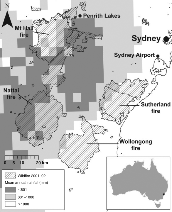
The Sydney region of south-eastern Australia (Fig. 1) is characterised by large areas of urban development surrounded by expanses of natural bushland. The dry sclerophyll eucalypt forests covering much of this area are highly flammable and characterised by rapid fuel accumulation (Fox et al. 1979; Morrison et al. 1996), which accompanied with periodic conditions of drought and extreme fire weather, make this region prone to recurrent large wildfires (Bradstock et al. 2009).
|
A gradient of decreasing mean annual precipitation occurs from east to west across the study region, inland from the coast. Near the coast (i.e. Sutherland and Wollongong) mean annual precipitation ranges from ~900 to 1500 mm, declining to ~600 to 1000 mm further west on the margins of the Blue Mountains (i.e. Mount Hall and Nattai) (Fig. 1; Bureau of Meteorology, see http://www.bom.gov.au/jsp/awap/rain/index.jsp, accessed 2 February 2010). Mean annual precipitation then increases in the Blue Mountains (i.e. within and to the west of the Mount Hall fire perimeter) (Fig. 1). The study focussed on this gradient of long-term average rainfall (Table 1). Mean daily maximum temperatures range from 25 to 31°C in the summer months and mean daily minimum temperatures range from 2 to 10°C in the winter months. Average maximum temperatures are typically greatest at the centre of the study region, declining towards the coast and mountains. Average minimum temperature tends to be greater on the coast than inland (www.bom.gov.au, accessed 7 March 2013).

|
The region is characterised by locally pronounced relief, consisting of ridges and plateaus that are dissected by networks of gullies and gorges (Fairley and Moore 2000). The average ridge–gully distance across the study area is ~400 m (Bradstock et al. 2010). Terrain becomes more deeply incised from the coast to the foothills of the Blue Mountains, which is reflected by the greater average slope and topographic position index (i.e. difference between site elevation and highest elevation within the surrounding 1000 × 1000-m window) in the Mount Hall and Nattai landscapes compared with Sutherland and Wollongong (Table 1). Triassic sandstones are the dominant geological substrate across the study region (Fairley and Moore 2000).
Vegetation across the study area is dominated by dry sclerophyll forest and woodland communities with an open canopy largely comprised of Eucalyptus, Corymbia and Angophora species (Keith 2004). Canopy species in these communities typically resprout following fire by epicormic buds beneath their bark, and have been shown to exhibit low rates of mortality (<5%) following high intensity crown fires (Bradstock 2008). Canopy height typically ranges from 10 to 30 m, and the understorey, dominated by sclerophyllous shrubs, is generally up to 4 m tall (Keith 2004). Variation in the structure and composition of these communities across the study region is driven largely by precipitation and soil fertility (Fairley and Moore 2000). The drier hinterland forests and woodlands (annual precipitation ~650–950 mm) of the study region have similar vegetative structure but a more open and less diverse shrub layer than the wetter coastal forests and woodlands (annual precipitation >1000 mm) (Keith 2004). Evidence suggests that fuel hazard development in dry sclerophyll forest and woodlands of this region is slower in drier cooler climates than wetter warmer climates (Watson et al. 2012), as has been found in other areas of southern Australia (Huston 2003).
The 2001–02 Sydney fires
The study focussed on four large fires (>40 000 ha; the Mount Hall, Nattai, Sutherland and Wollongong fires) that burnt during late December 2001 and early January 2002 (Fig. 1). All fires burnt under ‘Extreme’ weather conditions (temperature ~30–35°C; relative humidity 7–15%; wind speed 30–40 km h–1) on 25 December. Weather conditions eased between 27 and 30 December (temperature 20–30°C; relative humidity 20–60%; wind speed 10–30 km h–1), resulting in more moderate fire behaviour (Bradstock et al. 2010). The severity of these fires was mapped by Chafer et al. (2004) using SPOT 2 (Satellite Pour l’Observation de la Terre) imagery. This involved (i) computing the Normalised Difference Vegetation Index (NDVI) for pre- and post-fire images, (ii) calculating the difference between the pre- and post-fire NDVI (ΔNDVI; 20-m spatial resolution) and (iii) classifying ΔNDVI into six severity classes based on on-ground measures of vegetation consumption (Chafer et al. 2004). The classification had at least 88% accuracy (Chafer et al. 2004), with independent verification finding high levels of agreement (Hammill and Bradstock 2006). Bradstock et al. (2010) subsequently utilised this severity mapping to examine the relative influence that weather, time since fire, topographic position, slope and aspect had on patterns of fire severity for the Mount Hall and Nattai fires, which occur at the low end of the precipitation gradient (Fig. 1).
Our study utilises fire severity mapping derived by Chafer et al. (2004) to examine whether the effect of weather, topography and fuel age on fire severity is dependent upon annual precipitation. Six severity classes were mapped: (1) foliage and stems <10 mm in the shrub and tree canopy layer consumed, (2) shrub foliage consumed and tree canopy partially scorched or consumed, (3) understorey shrub fire with complete tree canopy scorch, (4) understorey shrub fire with partial tree canopy scorch, (5) understorey shrub fire with no tree canopy scorch and (6) unburnt. Binary reclassification was undertaken as per Bradstock et al. (2010) to permit two separate analyses focusing on (i) understorey fire (1: classes 3, 4, 5, 6; 0: classes 1, 2) and (ii) crown fire (1: class 1; 0: classes 2, 3, 4, 5, 6). Understorey fires (UF) are confined to the shrub and ground layers, with unburnt patches sometimes present. These fires burn at low to moderate intensity (i.e. <1500 kW m–1) and are potentially suppressible. Crown fires (CF) are those that enter the tree canopy (i.e. consuming all vegetation <10 mm thick) and burn at intensities at which fire suppression is not possible (10 000–70 000 kW m–1) (Bradstock et al. 2010).
Data
A combination of fire progression data and daily weather observations were utilised in order to identify the climatic conditions under which different parts of the study area burnt. Meteorological data from Penrith Lakes (station number 67113) and Sydney Airport (station number 66037) weather stations (Fig. 1) were used to calculate daily estimates of the McArthur Forest Fire Danger Index (FFDI), which is commonly used to assess fire risk across eucalypt forests (Noble et al. 1980). Fire weather was subsequently classified as extreme (EX – maximum FFDI 60–100) or non-extreme (NEX – maximum FFDI <35). A combination of MODIS satellite imagery, NOAA hotspot data, web fire mapper (http://firefly.geog.umd.edu/firemap/, accessed 3 February 2009) and written accounts (NSW Rural Fire Service, unpubl. data) were used to digitise progressive boundaries of the fires, and subsequently identify areas that burnt under EX (1100 hours–~1800 hours 25 December) and NEX (1100 hours 27 December–1100 hours 31 December) weather. The use of MODIS imagery and hotspots has been found to provide estimates of fire progression that are comparable to on-ground mapping (Bradstock et al. 2010). In order to increase sample size for NEX observations in the Sutherland fire additional areas that burnt under NEX weather (FFDI <20) between 3 and 6 January 2002 were included. These areas were identified using hotspots and fire progression records (NSW Office of Environment and Heritage, unpubl. data).
Three measures of topography were used in our analysis, namely topographic position, slope and aspect (Table 2). These layers were generated using digital elevation models (25-m resolution) obtained from the NSW Office of Environment and Heritage (OEH). Topographic position (TOPOS) was calculated as the difference in elevation (metres) between a pixel and the highest local point within a surrounding 1000 × 1000-m sample window. This provided a continuous measure of topographic position in which ridges are typically represented by small values and gullies are represented by large values. Slope was calculated using the Spatial Analyst Tool in ArcGIS (9.2). Aspect was calculated as a continuous measure relative to north as described in Penman et al. (2007), which resulted in values ranging from 0 to 180° (i.e. values approaching 0° represent northerly aspects, values approaching 180° represent southerly aspects).

|
Digitised fire history records (NSW OEH, unpubl. data) were used to create a layer of time since fire (TSF) from the 1976–77 fire season to the 2000–01 fire season. Areas with no recorded fires in this period were assigned the maximum TSF of 25 years. A range of fuel ages were recorded across the study sites (0–25 years), though these were heavily distributed towards the older age classes (i.e. >15 years; Table 2). A logarithmic transformation (i.e. ln[x+1]) was performed to TSF, due to the non-linear trend in fuel accumulation within eucalypt forests (Fox et al. 1979; Morrison et al. 1996; Penman and York 2010). Mean annual precipitation for the period 1977 to 2001 was calculated using monthly rainfall grids (0.05° resolution) obtained from the Bureau of Meteorology (http://www.bom.gov.au/jsp/awap/, accessed 2 February 2010). Details of the derivation of the monthly grids are provided in Jones et al. (2009). A proportional measure of mean annual precipitation (MAP) was used in the analyses as it facilitated model fitting. This was calculated by dividing the mean annual precipitation for a sample point by the mean of all sample points (mean = 1032 mm). Back-transformed values of mean annual precipitation are presented in figures for ease of interpretation.
A grid of data points with 400-m spacing was generated using ‘Hawths Tools’ (v3.27) in order to sample variables used in the analysis. Spacing of 400 m was utilised as it represents the typical ridge–gully distance across the study area, and hence the spatial grain at which fire severity consistently varies (Bradstock et al. 2010). Sampling was restricted to dry sclerophyll forest vegetation communities, as defined by Tindall et al. (2004), occurring within reasonably undisturbed vegetation located in National Parks, water catchments and military training areas. Sampling was excluded from within 40 m of fire trails and roads, 60 m of powerlines, 20 m of significant water bodies (i.e. dams, lakes, rivers with pooled water) and 100 m of conservation area boundaries. Data were extracted from layers of fire severity, weather, terrain, time since fire and precipitation at each sample point using the Spatial Analyst Tool in ArcGIS (9.2).
Data analysis
Spatial autocorrelation in fire severity data was assessed using Moran’s I, which is a measure of correlation between data points at different spatial proximities (Haining 2003). Values between one and six were assigned to each of the six ordinal categories of severity (as described earlier in the text) and used to calculate Moran’s I. A spatial variogram indicated that data were spatially autocorrelated (P < 0.000) up to a distance of 12 000 m, which approximately equates to the size of the sampling area within each fire. This suggests that spatial autocorrelation was only an issue within the perimeter of individual fires. A spatially lagged response variable (SLRV) was derived, as described in Haining (2003), from the classified fire severity data. For each data point, the SLRV represents the sum of the fire severity scores, transformed according to an inverse-distance weighting, within a 12 000-m radius. The following equation was used to calculate the SLRV for a data point (Threlfall et al. 2011):
where i represents the focal data point, j represents a point within the 12 000-m radius of the focal point, W represents the inverse distance between i and j and Y represents the response variable (i.e. fire severity). Low SLRV values will represent points where there is a large area of the surrounding landscape burnt at high severity and high SLRV values will represent areas where there is a large area of the surrounding landscape burnt at low severity. The SLRV was fitted as a model term in all models, in order to adjust model coefficients of predictors to account for the effect of spatial autocorrelation (Haining 2003). If spatial autocorrelation is present, the SLRV will show a significant negative relationship with CF and a positive relationship with UF.
Logistic regression was used to model the probability of occurrence of UF and CF as binary responses. The process used for testing assumptions and model selection was based on methodology described in Logan (2010) and Burnham and Anderson (2002). Prior to model fitting, the Pearson correlation coefficient and variance inflation factor were respectively used to test for correlation and multi-collinearity between predictor variables (Logan 2010). Correlation coefficients between predictor variables were generally small (i.e. <0.5), and coefficient estimates did not vary significantly when correlated variables were added to the same model, hence multicollinearity was assumed to be absent. Analyses were done using a randomly selected subset (75%) of the data. For each severity response (i.e. UF, CF) all combinations of weather, topographic position, slope, aspect, time since fire, mean annual precipitation and two way interactions involving mean annual precipitation were modelled. Akaike’s information criterion (AIC) was used to select the best model, whereby the model with the lowest AIC is considered to have the best fit (Burnham and Anderson 2002). Models within two AIC points of the model with the lowest AIC score are considered to have strong support and were considered as plausible alternatives, with the most parsimonious model being selected preferentially (Burnham and Anderson 2002).
The discriminative ability and predictive accuracy of each model was examined using the remaining 25% of the data. Discriminative ability of the models was assessed using Receiver Operating Characteristic area under curve (ROC AUC). A ROC AUC value of 1 indicates that a model has perfect discrimination, whereas a value of 0.5 would be the equivalent of a random guess (Pontius and Schneider 2001). The predictive accuracy of the models was assessed by calculating the proportion of data points for which a fire severity class was correctly assigned by each model. This was undertaken using a model cut-off point of 0.5 (i.e. predicted probability <0.5 was classed as 0; predicted probability ≥0.5 classed as 1). Model derivation, probability plots and ROC AUC analyses were done using the software package R v 2.11.1 (R Development Core Team 2010). The package ‘ROCR’ (Sing et al. 2009) was used to calculate ROC AUC and predictive accuracy.
Following the model selection process, hierarchical partitioning was used to assess how the relative contribution of weather, topography and time since fire to goodness of fit (i.e. root mean square ‘prediction’ error) changes under different levels of mean annual precipitation. The data were grouped into two precipitation categories (‘low’, ≤850 mm; ‘high’, >850 mm) and hierarchical partitioning was performed for both UF and CF within each precipitation category. Logistic regression was also performed and the Nagelkerke’s R2 index was calculated to facilitate comparison of the variability explained by each set of predictor variables. The R packages ‘hier.part’ (Walsh and Mac Nally 2012) and ‘Design’ (Harrell 2009) were respectively used for hierarchical partitioning and the calculation of R2 values.
Results
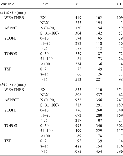
Understorey fire and crown fire were recorded at 41 and 24% of the 2320 sample locations (Table 3). There was a reasonable spread of sample points within the different levels of fire weather (WEATHER), topographic position (TOPOS), slope (SLOPE), aspect (ASPECT) and time since fire (TSF) across the range of mean annual precipitation (MAP; Table 3), indicating that the dataset was robust enough to assess interactions involving precipitation.
|
The best UF model contained TOPOS and interactions between MAP and weather, slope and TSF (Table 4). There were two plausible alternative models (i.e. ΔAIC <2), which contained the same core variables as the best model and an additional variable (i.e. ASPECT or an interaction between TOPOS and MAP). The alternative models were dismissed as they were more complex and had a lower goodness of fit than the best model. The significant interactions contained in this model indicate that the effect weather, TSF and slope have on the probability of UF decreases with increasing MAP (Fig. 2a–c). Fires of low intensity (UF) were more likely under non-extreme (NEX) weather than extreme (EX) weather (Fig. 2a), as expected. Increasing MAP led to a decreased likelihood of UF under NEX weather, but had little effect on the likelihood of UF under EX weather, as expected (Fig. 2a). In areas of the landscape receiving relatively low MAP (i.e. <850 mm), UF was more likely to occur in younger fuels (0– 5 years since fire) (Fig. 2b). However, as MAP increased (i.e. >1000 mm), the effect of TSF on the probability of UF diminished (Fig. 2b). Slope had a positive effect on the probability of UF, indicating that steeper areas were more likely to experience a fire confined to the understorey than flat areas, though the magnitude of change declined as MAP increased (Fig. 2c). The effect of TOPOS remained unchanged by MAP, with gullies (i.e. high TOPOS values) having a greater likelihood of UF than ridges. This model had a very good discriminative ability (ROC AUC = 0.851) and predictive accuracy (76.3%) when applied to the test dataset.
|

|
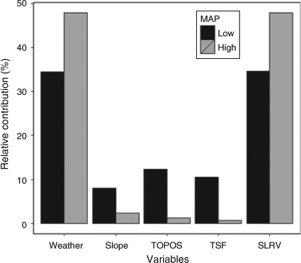
Hierarchical partitioning revealed that for UF the relative contribution of each variable to the model goodness of fit varied with MAP (Fig. 3). TOPOS, slope and TSF accounted for ~30% of explained variance (12.3, 8.1 and 10.6%) at sites experiencing ‘low’ (≤850 mm) MAP, but less than 5% (1.3, 2.3 and 0.6%) at sites experiencing ‘high’ (>850 mm) MAP (Fig. 3). Conversely, the relative contribution of weather and the spatially lagged response variable (SLRV; i.e. the neighbourhood influence) increased with increasing MAP, explaining ~35% of explained variance each under ‘low’ MAP and ~48% each under ‘high’ MAP (Fig. 3). However, R2 values from logistic regression models fitted to each dataset indicate that a greater amount of deviance in UF is explained under ‘low’ v. ‘high’ MAP (0.624 v. 0.499). This suggests that only the relative contribution of weather and the SLRV is altered by MAP, not the total deviance explained.
|
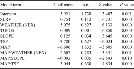
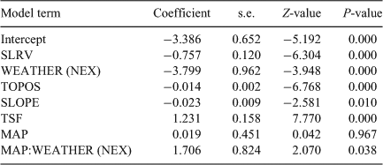
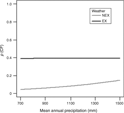
The best CF model contained TOPOS, slope, TSF and an interaction between weather and MAP (Table 5). There were five plausible alternative models (i.e. ΔAIC <2), which contained the same core variables as the best model and an additional variable. However, these models were dismissed as they were more complex and had a lower goodness of fit than the best model. CF was more likely to occur under EX than NEX weather (Fig. 4). However, the likelihood of CF under NEX did increase slightly with increasing MAP (Fig. 4). In general, areas burning under NEX weather were unlikely to experience CF. Hence, the influence of topography and TSF on CF occurrence was only evident under EX weather conditions. TSF had a positive effect on the probability of CF (Table 5), indicating that under EX weather long unburnt areas were more likely to experience CF than recently burnt areas. CF had a negative relationship with slope (Table 5), indicating that flat areas are more likely to experience CF. TOPOS had a positive effect on CF (Table 5), whereby ridges are more likely to experience CF than gullies. The ROC AUC and predictive accuracy of this model were very good, being 0.878 and 82.9%.
|
|
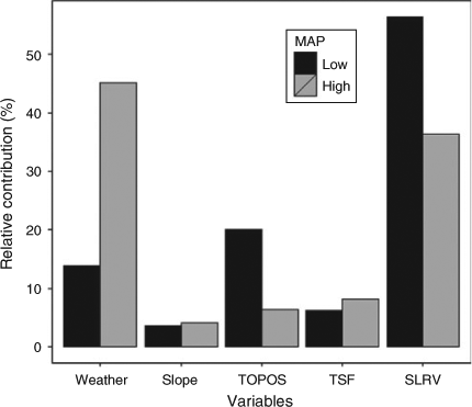
Under ‘low’ MAP, the severity of neighbouring pixels (i.e. SLRV) accounted for the majority (56.4%) of the explained variance in CF, with TOPOS, weather, TSF and slope accounting for 20.0, 13.9, 6.2 and 3.5% (Fig. 5). The small effect of weather at sites experiencing ‘low’ MAP can be attributed to the near absence of CF occurrence under NEX weather (Table 3). This result highlights the importance of weather in determining CF. Therefore, there was essentially no variance in CF under NEX weather to which the model could be fitted. It is likely that the effect of weather in the ‘low’ MAP dataset has been absorbed by the SLRV (Fig. 5), as sample points that are in close spatial proximity typically burnt under the same weather conditions. Under ‘high’ MAP, weather and the SLRV accounted for 81.5% of explained variance (Fig. 5). The relative contribution of TSF and slope remained relatively constant across both ‘low’ and ‘high’ MAP, whereas the contribution of TOPOS declined with increasing MAP (Fig. 5). Model R2 values were greater for the ‘low’ MAP dataset (R2 = 0.571) than the ‘high’ MAP dataset (R2 = 0.360).
|
Discussion
Fire severity patterns
The effects of weather, slope and fuel age on the occurrence of potentially suppressible fire (i.e. UF) varied spatially with mean annual precipitation across dry sclerophyll forests of the Sydney region of south-eastern Australia. Weather, topography and time since fire can influence patterns in fire behaviour by altering fuel load and moisture, and hence the amount of fuel available to burn (Catchpole 2002). The evidence suggested that in environments with high mean annual precipitation the inhibitory effect of young fuel ages on severity, evident in drier environments, were greatly diminished. This is presumably due to more rapid accumulation of fine fuels in wetter environments (Huston 2003). Although decomposition rates have been shown to increase with precipitation (Austin 2002; Penman and York 2010), decreased decomposition rates in the first couple of years following fire (Penman and York 2010) may counterbalance this effect. Drought in the months preceding the 2001–02 Sydney fires ensured fuel across much of the study region was sufficiently dry to burn (Chafer et al. 2004; Caccamo et al. 2012). Thus, differences in fuel moisture were unlikely to have affected severity among the study sites at the time of the fires.
The varied effect of both weather and slope on UF across the gradient of mean annual precipitation probably reflects changes in fuel biomass and connectivity. The likelihood of fire being confined to the understorey (i.e. UF) decreased with increasing mean annual precipitation under NEX weather (Fig. 2a). It is likely that greater fuel loads, including a well developed mid-layer of sclerophyllous shrubs, associated with increased precipitation (Huston 2003; Keith 2004) are responsible for this trend. Fire behaviour models for eucalypt forest predict that if weather (i.e. FFDI) is held constant, fire intensity will be greater under higher fuel loads (Gill et al. 1987), which supports our explanation. Steep slopes were more likely to experience understorey fire than gentle slopes when mean annual precipitation was low and weather was NEX. This is most likely due to discontinuous fuels associated with rock outcropping on steep slopes (Bradstock et al. 2010). However, the effect of slope became more benign as annual precipitation increased (Fig. 2c), presumably due to increased fuel continuity associated with wetter areas.
Crown fires are strongly driven by fire weather (i.e. high temperatures, low humidity, strong winds) (Luke and McArthur 1978; Thompson and Spies 2009; Price and Bradstock 2012), which may explain why mean annual precipitation had little effect on the occurrence of these fires. Under NEX weather there was a small increase in the likelihood of crown fire when going from low to high mean annual precipitation (Fig. 4). This probably reflects the influence that the vertical continuity of fuels have on the incidence of CF (Luke and McArthur 1978; Catchpole 2002; Sullivan et al. 2012). Tall shrubs and tree bark (i.e. fibrous bark or long bark ribbons) provide vertical continuity between litter and canopy fuels and therefore increase the likelihood of CF (Sullivan et al. 2012). Forests within the wetter regions of the study area typically have greater shrub cover than those in the drier regions (Keith 2004). Bark and shrub fuels (i.e. biomass and structure) may also take several decades to fully develop this potential in dry sclerophyll forests and woodlands (Fox et al. 1979; Department of Sustainability and Environment 2003). This would explain why there was a greater likelihood of CF in long unburnt areas. Obligate seeders and basal resprouters, which are species that are effectively returned to a juvenile phase following fire, are a major component of the shrub layer within dry sclerophyll forest communities of the Sydney region (Bradstock and Kenny 2003). Therefore, the post-fire recovery of shrub fuel structure will be strongly time dependent, which may help explain why mean annual precipitation had no effect on the relationship between fuel age and CF occurrence.
Topographic position appeared to have a consistent effect on fire severity across the region regardless of mean annual precipitation (Table 4), whereby gullies typically experienced fires confined to the understorey. Although the amount of variance explained by topographic position was lower in areas of ‘high’ v. ‘low’ mean annual precipitation (Fig. 3), this merely reflects the tendency for coastal areas with high mean annual precipitation to have lower topographic relief (Table 1). Ridges typically experienced more severe fire, and CF generally only occurred on long unburnt ridges under extreme fire weather. Reduced fire severity and fire occurrence within gullies and riparian areas is commonly reported in temperate forests (Taylor and Skinner 1998; Beaty and Taylor 2001; Penman et al. 2007; Wood et al. 2011), though variation in this trend may occur across landscapes and fire events (see Dwire and Kauffman 2003). Greater fuel moisture and reduced wind exposure within gullies are the most probable explanations for the patterns observed in our study (Bradstock et al. 2010).
The amount of variation in fire severity explained by our models will be inherently limited by the quality and availability of explanatory data (e.g. fire history, fuel moisture), an issue relevant to all studies of this nature. For example, the fire history database used to calculate time since fire contained virtually no information on fire severity and patchiness, which will directly influence post-fire fuel accumulation rates. This will have generated noise in the modelled relationships between time since fire and fire severity. Similarly, we were unable to directly measure and account for fuel moisture before the fires at an appropriate spatial scale. Satellite imagery has the potential to provide broad scale fuel load and fuel moisture information (e.g. Chafer et al. 2004; Caccamo et al. 2012), though products with both appropriate spatial resolution (e.g. ~10 m) and return intervals (e.g. days) are not readily available. Fire suppression activities (i.e. backburning, aerial water bombing, on-ground fire fighting), which may influence patterns in fire severity, were not accounted for in our analysis. However, the overall size of the complex of fires burning at the time meant that suppression resources were thinly spread. Therefore, the resultant chance of sampling areas where severity may have been reduced by suppression was probably low.
Management implications and climate change
The results of our study suggest that the time period over which fuel reduction burning is effective (i.e. reduces fire intensity to potentially suppressible levels) may vary across the dry sclerophyll forests of the study region. Following fire there may be a 0– 5 year window within which treated fuels are more likely to reduce fire intensity to potentially suppressible levels (i.e. UF) under extreme weather conditions. This supports the general consensus that fine fuels will approach pre-fire levels 2–5 years following fire in sclerophyll forests and woodlands of temperate Australia (Fox et al. 1979; Morrison et al. 1996; Penman and York 2010). However, this window of effectiveness appears to shorten as mean annual precipitation increases (Fig. 2b), presumably in response to increased rates of fine fuel accumulation. As time since fire included both wildfire and prescribed burns, the former of which is generally associated with greater fuel consumption, it is possible that the window of hazard reduction burning effectiveness may be shorter than that stated here. Regardless, fire management programs will need to be responsive to such spatial variation in the effectiveness of fuel reduction (Schoennagel et al. 2004). For example, if hazard reduction burning only reduces fire severity to potentially suppressible levels within the first couple of years following fire in ‘mesic’ parts of the landscape, then the broad scale application of this management technique will not be the most effective way to manage fire risk.
The dominant effect of weather on fire severity further emphasises that the effectiveness of fire risk management strategies (e.g. fuel reduction, suppression) will be highly constrained by fire weather conditions (McCarthy and Tolhurst 2001; Fernandes and Botelho 2003; Price and Bradstock 2012). There is some evidence from eucalypt forests in southern Australia that areas recently burnt (i.e. <5–10 years since fire) by prescribed burns and wildfires will alter wildfire behaviour, even reducing the occurrence of CF under very high to extreme weather conditions (Fernandes and Botelho 2003; Bradstock et al. 2010). However, analysis of 114 fires by McCarthy and Tolhurst (2001) has shown that the effectiveness of fuel reduction burning (i.e. the capacity to assist suppression) is reduced with increasing severity of fire weather, particularly with a FFDI of ~25–50. Price and Bradstock (2012) revealed that time since fire had negligible effect in terms of reducing fire severity to potentially suppressible levels under very high (mean FFDI = 36) and catastrophic conditions (mean FFDI = 103) in eucalypt forest during the 2009 fires in Victoria, Australia. Extreme weather conditions pose the greatest threat to life and property (Luke and McArthur 1978; Blanchi et al. 2010; Price and Bradstock 2012) and consequently represent conditions when fire management actions need to be effective (Fernandes and Botelho 2003). Therefore, the identification of conditions that constrain the effectiveness of fuel reduction burning will be crucial for enhancing fire management strategies and fire fighter safety.
Climate change is predicted to increase fire occurrence in temperate eucalypt forests of southern Australia, largely due to an increased frequency of extreme fire weather events (Bradstock 2010; Bradstock et al. 2012; Cary et al. 2012). Our findings, and past research (e.g. Bradstock et al. 2010; King et al. 2011; Bradstock et al. 2012; Price and Bradstock 2012), suggest that increased occurrence of extreme weather events may result in a shift towards fires of greater severity and intensity in temperate eucalypt forests. Projected reductions in annual precipitation (e.g. median decrease of 4–8% for Sydney in 2070; CSIRO and Australian Bureau of Meteorology 2007) and associated declines in fuel production under predicted future climates may partially offset these changes to fire occurrence (Bradstock 2010; Cary et al. 2012) and intensity (Fig. 2). As discussed above, the window of fuel reduction burning effectiveness may increase under drier conditions. Therefore, future conditions of reduced precipitation are likely to enhance fuel reduction burning efficacy. However, the short window of fuel reduction burning effectiveness (i.e. <5 years) coupled with the dominant effect of fire weather (Fig. 2), suggests that the potential for broad scale fuel reduction burning to mitigate enhanced fire risk under future climate is likely to remain constrained in temperate dry sclerophyll forests.
Conclusions
The importance of precipitation regimes in determining the relative influence fire weather, topography and fuel age have on fire regimes has been highlighted across a range of ecosystems globally (Schoennagel et al. 2004; Seydack et al. 2007; Archibald et al. 2009; Bradstock 2010). Our study provides further evidence of this phenomenon, revealing that precipitation regimes can shape these relationships even within a reasonably homogenous expanse of eucalypt forest, whereby the relative effect fire weather, slope and fuel age had on the occurrence of potentially suppressible understorey fire decreased with increasing mean annual precipitation. Fuel production rates, fuel accumulation and biomass are positively related to annual precipitation across a range of fire prone ecosystems (Austin 2002; Huston 2003; Govender et al. 2006; Pekin et al. 2009), which suggests that our findings will have broader generality. Consequently, fire management strategies will need to be adaptable to spatial variation in mean annual precipitation and in response to future changes in precipitation regimes, as has been suggested for other ecosystems globally (Schoennagel et al. 2004; Archibald et al. 2009; Bradstock 2010).
Acknowledgements
The authors thank the New South Wales Office of Environment and Heritage and Sydney Catchment Authority for provision of data. Stefan Maier kindly provided reclassified MODIS images and advice on the use of remote sensing for detection of fire boundaries. Ken Russell provided advice on statistical analysis. Elizabeth Tasker and Ben Gooden kindly provided comments on an earlier draft of this manuscript. The quality of the manuscript was greatly improved by comments from two anonymous reviewers.
References
Archibald S, Roy DP, Van Wilgen BW, Scholes RJ (2009) What limits fire? An examination of drivers of burnt area in Southern Africa. Global Change Biology 15, 613–630.| What limits fire? An examination of drivers of burnt area in Southern Africa.Crossref | GoogleScholarGoogle Scholar |
Austin AT (2002) Differential effects of precipitation on productivity and decomposition along a rainfall gradient in Hawaii. Ecology 83, 328–338.
Beaty RM, Taylor AH (2001) Spatial and temporal variation of fire regimes in a mixed conifer forest landscape, Southern Cascades, California, USA. Journal of Biogeography 28, 955–966.
| Spatial and temporal variation of fire regimes in a mixed conifer forest landscape, Southern Cascades, California, USA.Crossref | GoogleScholarGoogle Scholar |
Blanchi R, Lucas C, Leonard J, Finkele K (2010) Meteorological conditions and wildfire-related houseloss in Australia. International Journal of Wildland Fire 19, 914–926.
Bradstock RA (2008) Effects of large fires on biodiversity in south-eastern Australia: disaster or template for diversity? International Journal of Wildland Fire 17, 809–822.
| Effects of large fires on biodiversity in south-eastern Australia: disaster or template for diversity?Crossref | GoogleScholarGoogle Scholar |
Bradstock RA (2010) A biogeographic model of fire regimes in Australia: current and future implications. Global Ecology and Biogeography 19, 145–158.
| A biogeographic model of fire regimes in Australia: current and future implications.Crossref | GoogleScholarGoogle Scholar |
Bradstock RA, Kenny BJ (2003) An application of plant functional types to fire management in a conservation reserve in southeastern Australia. Journal of Vegetation Science 14, 345–354.
| An application of plant functional types to fire management in a conservation reserve in southeastern Australia.Crossref | GoogleScholarGoogle Scholar |
Bradstock RA, Gill AM, Kenny BJ, Scott J (1998) Bushfire risk at the urban interface estimated from historical weather records: consequences for the use of prescribed fire in the Sydney region of south-eastern Australia. Journal of Environmental Management 52, 259–271.
| Bushfire risk at the urban interface estimated from historical weather records: consequences for the use of prescribed fire in the Sydney region of south-eastern Australia.Crossref | GoogleScholarGoogle Scholar |
Bradstock RA, Cohn JS, Gill AM, Bedward M, Lucas C (2009) Prediction of the probability of large fires in the Sydney region of south-eastern Australia using fire weather. International Journal of Wildland Fire 18, 932–943.
| Prediction of the probability of large fires in the Sydney region of south-eastern Australia using fire weather.Crossref | GoogleScholarGoogle Scholar |
Bradstock RA, Hammill KA, Collins L, Price O (2010) Effects of weather, fuel and terrain on fire severity in topographically diverse landscapes of south-eastern Australia. Landscape Ecology 25, 607–619.
| Effects of weather, fuel and terrain on fire severity in topographically diverse landscapes of south-eastern Australia.Crossref | GoogleScholarGoogle Scholar |
Bradstock RA, Cary GJ, Davies I, Lindenmayer DB, Price OF, Williams RJ (2012) Wildfires, fuel treatment and risk mitigation in Australian eucalypt forests: insights from landscape-scale simulation. Journal of Environmental Management 105, 66–75.
| Wildfires, fuel treatment and risk mitigation in Australian eucalypt forests: insights from landscape-scale simulation.Crossref | GoogleScholarGoogle Scholar | 1:STN:280:DC%2BC38rnvVGitA%3D%3D&md5=d10e9b2b88e4ff6d1f4e9e83276fb3daCAS | 22531752PubMed |
Burnham KP, Anderson DR (2002) ‘Model Selection and Multi-Model Inference: a Practical Information–Theoretic Approach (2nd Edition)’, 2nd edn (Springer: Secaucus, NJ)
Caccamo G, Chisholm LA, Bradstock RA, Puotinen M, Pippen BG (2012) Remote monitoring of live fuel moisture content of fire prone vegetation types using MODIS satellite data. International Journal of Wildland Fire 21, 257–269.
| Remote monitoring of live fuel moisture content of fire prone vegetation types using MODIS satellite data.Crossref | GoogleScholarGoogle Scholar |
Camp A, Oliver C, Hessburg P, Everett R (1997) Predicting late-successional fire refugia pre-dating European settlement in the Wenatchee Mountains. Forest Ecology and Management 95, 63–77.
| Predicting late-successional fire refugia pre-dating European settlement in the Wenatchee Mountains.Crossref | GoogleScholarGoogle Scholar |
Cary GJ, Bradstock RA, Gill AM, Williams RJ (2012) Global change and fire regimes in Australia. In ‘Flammable Australia: Fire Regimes, Biodiversity and Ecosystems in a Changing World’. (Eds RA Bradstock, AM Gill, RJ Williams) pp. 149–169. (CSIRO Publishing: Melbourne)
Catchpole W (2002) Fire properties and burn patterns in heterogeneous landscapes. In ‘Flammable Australia: Fire Regimes and Biodiversity of a Continent’. (Eds RA Bradstock, JE Williams, AM Gill) pp. 49–76. (Cambridge University Press: Melbourne)
Chafer CJ, Noonan M, Macnaught E (2004) The post-fire measurement of fire severity and intensity in the Christmas 2001 Sydney wildfires. International Journal of Wildland Fire 13, 227–240.
| The post-fire measurement of fire severity and intensity in the Christmas 2001 Sydney wildfires.Crossref | GoogleScholarGoogle Scholar |
Collins BM, Kelly M, van Wagtendonk JW, Stephens SL (2007) Spatial patterns of large natural fires in Sierra Nevada wilderness areas. Landscape Ecology 22, 545–557.
| Spatial patterns of large natural fires in Sierra Nevada wilderness areas.Crossref | GoogleScholarGoogle Scholar |
CSIRO, Australian Bureau of Meteorology (2007) Climate change in Australia: technical report 2007. (CSIRO) Available at http://www. climatechangeinaustralia.gov.au/ [Verified 29 October 2012]
Department of Sustainability and Environment (2003) Ecological impacts of fuel reduction burning in a mixed eucalypt foothill forest – summary report (1984–1999). Fire Research Report number 57, Department of Sustainability and Environment. (Melbourne)
Dwire KA, Kauffman JB (2003) Fire and riparian ecosystems in landscapes of the western USA. Forest Ecology and Management 178, 61–74.
| Fire and riparian ecosystems in landscapes of the western USA.Crossref | GoogleScholarGoogle Scholar |
Fairley A, Moore P (2000) ‘Native Plants of the Sydney District: an Identification Guide.’ (Kangaroo Press: Sydney)
Fernandes PM, Botelho HS (2003) A review of prescribed burning effectiveness in fire hazard reduction. International Journal of Wildland Fire 12, 117–128.
| A review of prescribed burning effectiveness in fire hazard reduction.Crossref | GoogleScholarGoogle Scholar |
Fox BJ, Fox MD, McKay GM (1979) Litter accumulation after fire in a eucalypt forest. Australian Journal of Botany 27, 157–165.
| Litter accumulation after fire in a eucalypt forest.Crossref | GoogleScholarGoogle Scholar |
Franklin JF, Spies TA, Van Pelt R, Carey AB, Thornburgh DA, Rae Berg D, Lindenmayer DB, Harmon ME, Keeton WS, Shaw DC, Bible K, Chen J (2002) Disturbances and structural development of natural forest ecosystems with silvicultural implications, using Douglas-fir forests as an example. Forest Ecology and Management 155, 399–423.
| Disturbances and structural development of natural forest ecosystems with silvicultural implications, using Douglas-fir forests as an example.Crossref | GoogleScholarGoogle Scholar |
Gill AM, Christian KR, Moore PHR (1987) Bushfire incidence, fire hazard and fuel reduction burning. Australian Journal of Ecology 12, 299–306.
| Bushfire incidence, fire hazard and fuel reduction burning.Crossref | GoogleScholarGoogle Scholar |
Govender N, Trollope WSW, van Wilgen BW (2006) The effect of fire season, fire frequency, rainfall and management on fire intensity in savanna vegetation in South Africa. Journal of Applied Ecology 43, 748–758.
| The effect of fire season, fire frequency, rainfall and management on fire intensity in savanna vegetation in South Africa.Crossref | GoogleScholarGoogle Scholar |
Haining R (2003) ‘Spatial Data Analysis: Theory and Practice.’ (Cambridge University Press: New York)
Hammill KA, Bradstock RA (2006) Remote sensing of fire severity in the Blue Mountains: influence of vegetation type and inferring fire intensity. International Journal of Wildland Fire 15, 213–226.
| Remote sensing of fire severity in the Blue Mountains: influence of vegetation type and inferring fire intensity.Crossref | GoogleScholarGoogle Scholar |
Harrell FE (2009). Design: design package. R package version 2.3–0. Available at http://cran.r-project.org/src/contrib/Archive/Design/ [Verified 16 July 2013]
Huston M (2003) Understanding the effects of fire and other mortality causing disturbances on species diversity. In ‘Fire in Ecosystems of South-west Western Australia: Impacts and Management’. (Eds I Abbott, N Burrows) pp. 37–70. (Backhuys Publishers: Leiden, the Netherlands)
Jones DA, Wang W, Fawcett R (2009) High-quality spatial climate data-sets for Australia. Australian Meteorological and Oceanographic Journal 58, 233–248.
Kauffman JB (2001) Workshop on the multiple influences of riparian/stream ecosystems on fires in western forest landscapes. Summary report. USDA Forest Service, Rocky Mountain Research Station, Stream Systems Technology Center. (Fort Collins, CO) Available at http://stream.fs.fed.us/publications/PDFs/Riparian%20Fire%20Final.pdf [Verified 16 July 2013]
Keeley JE (2009) Fire intensity, fire severity and burn severity: a brief review and suggested usage. International Journal of Wildland Fire 18, 116–126.
| Fire intensity, fire severity and burn severity: a brief review and suggested usage.Crossref | GoogleScholarGoogle Scholar |
Keith D (2004) ‘Ocean Shores to Desert Dunes: the Native Vegetation of New South Wales and the ACT.’ (Department of Environment and Conservation: Sydney)
Keith H, Mackey BG, Lindenmayer DB (2009) Re-evaluation of forest biomass carbon stocks and lessons from the world’s most carbon-dense forests. Proceedings of the National Academy of Sciences of the United States of America 106, 11 635–11 640.
King KJ, de Ligt RM, Cary GJ (2011) Fire and carbon dynamics under climate change in south-eastern Australia: insights from FullCAM and FIRESCAPE modelling. International Journal of Wildland Fire 20, 563–577.
| Fire and carbon dynamics under climate change in south-eastern Australia: insights from FullCAM and FIRESCAPE modelling.Crossref | GoogleScholarGoogle Scholar | 1:CAS:528:DC%2BC3MXnslOmtrY%3D&md5=fa1be41109372653522ce51a05b0f80aCAS |
Krawchuk MA, Moritz MA (2011) Constraints on global fire activity vary across a resource gradient. Ecology 92, 121–132.
| Constraints on global fire activity vary across a resource gradient.Crossref | GoogleScholarGoogle Scholar | 21560682PubMed |
Lentile LB, Holden ZA, Smith AM, Falkowski MJ, Hudak AT, Morgan P, Lewis SA, Gessler PE, Benson NC (2006) Remote sensing techniques to assess active fire characteristics and post-fire effects. International Journal of Wildland Fire 15, 319–345.
| Remote sensing techniques to assess active fire characteristics and post-fire effects.Crossref | GoogleScholarGoogle Scholar |
Logan M (2010) ‘Biostatistical Design and Analysis using R: a Practical Guide.’ (Wiley Blackwell: Chichester, UK)
Luke RH, McArthur AG (1978) Bushfires in Australia. Department of Primary Industries, Forestry and Timber Bureau, CSIRO Division of Forest Research. (Canberra)
Mackey B, Lindenmayer D, Gill M, McCarthy M, Lindesay J (2002) ‘Wildlife, Fire and Future Climate: a Forest Ecosystem Analysis.’ (CSIRO Publishing: Melbourne)
McCarthy GJ, Tolhurst KG (2001) ‘Effectiveness of broadscale fuel reduction burning in assisting with wildfire control in parks and forests in Victoria’ Natural Resources and Environment, Fire Management Research Report number 51. (Melbourne)
Morrison DA, Buckney RT, Bewick BJ (1996) Conservation conflicts over burning bush in south-eastern Australia. Biological Conservation 76, 167–175.
| Conservation conflicts over burning bush in south-eastern Australia.Crossref | GoogleScholarGoogle Scholar |
Murphy BP, Russell-Smith J (2010) Fire severity in a northern Australian savanna landscape: the importance of time since previous fire. International Journal of Wildland Fire 19, 46–51.
| Fire severity in a northern Australian savanna landscape: the importance of time since previous fire.Crossref | GoogleScholarGoogle Scholar |
Noble IR, Bary GAV, Gill AM (1980) McArthur’s fire-danger meters expressed as equations. Australian Journal of Ecology 5, 201–203.
| McArthur’s fire-danger meters expressed as equations.Crossref | GoogleScholarGoogle Scholar |
Parisien M, Snetsinger S, Greenberg JA, Nelson CR, Schoennagel T, Dobrowski SZ, Moritz MA (2012) Spatial variability in wildfire probability across the western United States. International Journal of Wildland Fire 21, 313–327.
| Spatial variability in wildfire probability across the western United States.Crossref | GoogleScholarGoogle Scholar |
Pekin BK, Boer MM, Macfarlane C, Grierson PF (2009) Impacts of increased fire frequency and aridity on eucalypt forest structure, biomass and composition in southwest Australia. Forest Ecology and Management 258, 2136–2142.
| Impacts of increased fire frequency and aridity on eucalypt forest structure, biomass and composition in southwest Australia.Crossref | GoogleScholarGoogle Scholar |
Penman TD, York A (2010) Climate and recent fire history affect fuel loads in Eucalyptus forests: implications for fire management in a changing climate. Forest Ecology and Management 260, 1791–1797.
| Climate and recent fire history affect fuel loads in Eucalyptus forests: implications for fire management in a changing climate.Crossref | GoogleScholarGoogle Scholar |
Penman TD, Kavanagh RP, Binns DL, Melick DR (2007) Patchiness of prescribed burns in dry sclerophyll eucalypt forests in south-eastern Australia. Forest Ecology and Management 252, 24–32.
| Patchiness of prescribed burns in dry sclerophyll eucalypt forests in south-eastern Australia.Crossref | GoogleScholarGoogle Scholar |
Penman TD, Christie FJ, Andersen AN, Bradstock RA, Cary GJ, Henderson MK, Price O, Tran C, Wardle GM, Williams RJ, York A (2011) Prescribed burning: how can it work to conserve the things we value? International Journal of Wildland Fire 20, 721–733.
| Prescribed burning: how can it work to conserve the things we value?Crossref | GoogleScholarGoogle Scholar |
Perry DA, Hessburg PF, Skinner CN, Spies TA, Stephens SL, Henry Taylor A, Franklin JF, McComb B, Riegel G (2011) The ecology of mixed severity fire regimes in Washington, Oregon, and Northern California. Forest Ecology and Management 262, 703–717.
| The ecology of mixed severity fire regimes in Washington, Oregon, and Northern California.Crossref | GoogleScholarGoogle Scholar |
Plucinski MP, McCarthy GJ, Hollis JJ, Gould JS (2012) The effect of aerial suppression on the containment time of Australian wildfires estimated by fire management personnel. International Journal of Wildland Fire 21, 219–229.
| The effect of aerial suppression on the containment time of Australian wildfires estimated by fire management personnel.Crossref | GoogleScholarGoogle Scholar |
Pontius RG, Schneider LC (2001) Land-cover change model validation by an ROC method for the Ipswich watershed, Massachusetts, USA. Agriculture, Ecosystems & Environment 85, 239–248.
| Land-cover change model validation by an ROC method for the Ipswich watershed, Massachusetts, USA.Crossref | GoogleScholarGoogle Scholar |
Price OF, Bradstock RA (2012) The efficacy of fuel treatment in mitigating property loss during wildfires: Insights from analysis of the severity of the catastrophic fires in 2009 in Victoria, Australia. Journal of Environmental Management 113, 146–157.
| The efficacy of fuel treatment in mitigating property loss during wildfires: Insights from analysis of the severity of the catastrophic fires in 2009 in Victoria, Australia.Crossref | GoogleScholarGoogle Scholar | 23025983PubMed |
R Development Core Team (2010) R: A Language and Environment for Statistical Computing. (R Foundation for Statistical Computing: Vienna, Austria)
Schoennagel T, Velben TT, Romme WH (2004) The interaction of fire, fuels and climate across Rocky Mountain forests. Bioscience 54, 661–676.
| The interaction of fire, fuels and climate across Rocky Mountain forests.Crossref | GoogleScholarGoogle Scholar |
Schoennagel T, Smithwick EA, Turner MG (2008) Landscape heterogeneity following large fires: insights from Yellowstone National Park, USA. International Journal of Wildland Fire 17, 742–753.
| Landscape heterogeneity following large fires: insights from Yellowstone National Park, USA.Crossref | GoogleScholarGoogle Scholar |
Seydack AHW, Bekker SJ, Marshall AH (2007) Shrubland fire regime scenarios in the Swartberg Mountain Range, South Africa: implications for fire management. International Journal of Wildland Fire 16, 81–95.
| Shrubland fire regime scenarios in the Swartberg Mountain Range, South Africa: implications for fire management.Crossref | GoogleScholarGoogle Scholar |
Sing T, Sander O, Beerenwinkel N, Lengauer T (2009). ROCR: Visualizing the performance of scoring classifiers. R package version 1.0–4. Available at http://cran.r-project.org/web/packages/ROCR/index.html [Verified 16 July 2013]
Sullivan AL, McCaw WL, Cruz MG, Matthews S, Ellis PF (2012) Fuel, fire weather and fire behaviour in Australian ecosystems. In ‘Flammable Australia: Fire Regimes, Biodiversity and Ecosystems in a Changing World’. (Eds RA Bradstock, AM Gill, RJ Williams) pp. 51–77 (CSIRO Publishing: Melbourne)
Taylor AH, Skinner CN (1998) Fire history and landscape dynamics in a late-successional reserve, Klamath Mountains, California, USA. Forest Ecology and Management 111, 285–301.
| Fire history and landscape dynamics in a late-successional reserve, Klamath Mountains, California, USA.Crossref | GoogleScholarGoogle Scholar |
Thompson JR, Spies TA (2009) Vegetation and weather explain variation in crown damage within a large mixed-severity wildfire. Forest Ecology and Management 258, 1684–1694.
| Vegetation and weather explain variation in crown damage within a large mixed-severity wildfire.Crossref | GoogleScholarGoogle Scholar |
Threlfall C, Law B, Penman T, Banks PB (2011) Ecological processes in urban landscapes: mechanisms influencing the distribution and activity of insectivorous bats. Ecography 34, 814–826.
| Ecological processes in urban landscapes: mechanisms influencing the distribution and activity of insectivorous bats.Crossref | GoogleScholarGoogle Scholar |
Tindall D, Pennay C, Tozer M, Turner K, Keith D (2004) Native vegetation map report series. Number 4. NSW Department of Environment and Conservation and NSW Department of Infrastructure, Planning and Natural Resources. (Sydney)
Walsh C, Mac Nally R (2012) hier.part: Hierarchical Partitioning. R package version 1.0–3. Available at http://cran.r-project.org/web/packages/hier.part/index.html [Verified 16 July 2013]
Watson P, Penman S, Horsey B (2012) Bushfire fuels in NSW forests and grassy woodlands: fuel modelling project final report. Centre for Environmental Risk Management of Bushfire, University of Wollongong. (Wollongong, NSW)
Wood SW, Murphy BP, Bowman DMJS (2011) Firescape ecology: how topography determines the contrasting distribution of fire and rain forest in the south-west of the Tasmanian Wilderness World Heritage Area. Journal of Biogeography 38, 1807–1820.
| Firescape ecology: how topography determines the contrasting distribution of fire and rain forest in the south-west of the Tasmanian Wilderness World Heritage Area.Crossref | GoogleScholarGoogle Scholar |