

Is fire severity increasing in the Sierra Nevada, California, USA?
Chad T. Hanson A C and Dennis C. Odion BA Earth Island Institute, 2150 Allston Way, Suite #460, Berkeley, CA 94704, USA.
B Earth Research Institute, University of California, Santa Barbara, 93106 and Environmental Studies Department, Southern Oregon University, Ashland, OR 97520, USA.
C Corresponding author. Email: cthanson1@gmail.com
International Journal of Wildland Fire 23(1) 1-8 https://doi.org/10.1071/WF13016
Submitted: 1 February 2013 Accepted: 30 May 2013 Published: 10 September 2013
Abstract
Research in the Sierra Nevada range of California, USA, has provided conflicting results about current trends of high-severity fire. Previous studies have used only a portion of available fire severity data, or considered only a portion of the Sierra Nevada. Our goal was to investigate whether a trend in fire severity is occurring in Sierra Nevada conifer forests currently, using satellite imagery. We analysed all available fire severity data, 1984–2010, over the whole ecoregion and found no trend in proportion, area or patch size of high-severity fire. The rate of high-severity fire has been lower since 1984 than the estimated historical rate. Responses of fire behaviour to climate change and fire suppression may be more complex than assumed. A better understanding of spatiotemporal patterns in fire regimes is needed to predict future fire regimes and their biological effects. Mechanisms underlying the lack of an expected climate- and time since fire-related trend in high-severity fire need to be identified to help calibrate projections of future fire. The effects of climate change on high-severity fire extent may remain small compared with fire suppression. Management could shift from a focus on reducing extent or severity of fire in wildlands to protecting human communities from fire.
Additional keywords: conifer forests, early-successional habitat, fire-dependent biota, high-severity fire.
Introduction
There is widespread concern about an increase in fire severity in the forests of the western United States (Agee and Skinner 2005; Stephens and Ruth 2005; Littell et al. 2009). It has been hypothesised that fire severity is increasing due to decades of fire suppression and fuel accumulation (Stephens and Ruth 2005) and climate change (Westerling et al. 2006). Excess fire is a concern for the maintenance of sufficient levels of old-growth forest for different elements of biodiversity that may be fairly fire sensitive and that have lost habitat due to logging. For example, rare wildlife species such as the Pacific fisher (Martes pennanti) in the Sierra Nevada range are associated with dense, older forest. Recent modelling of this species’ viability has assumed that future fire will burn with ~90% tree mortality in the Sierra Nevada (He and Mladenoff 1999; Spencer et al. 2008; Scheller et al. 2011; Syphard et al. 2011; Thompson et al. 2011).
Conversely, there are also concerns that fire suppression and post-fire management has reduced natural early-successional habitat created by fire (Hutto 2006; Odion and Hanson 2006; Swanson et al. 2011), including in the Sierra Nevada (Nagel and Taylor 2005; Odion and Hanson 2006, 2008). High-severity fire has key ecological and evolutionary implications. Many species or vital life history stages (e.g. germination) are endemic to conditions created by high-severity fire, and some rare wildlife indicator species, such as the Black-backed Woodpecker (Picoides arcticus), depend upon such habitat (Hanson and North 2008; Hutto 2008). Due to the richness of biological legacies (e.g. snags, downed logs, patches of montane chaparral) in natural early-successional habitat created by high-severity fire, abundance and diversity of plant and animal species is high (Lindenmayer and Franklin 2002; Swanson et al. 2011). For many species, post-fire habitat occupancy is brief. Therefore, early-successional habitat created by fire must be continuously replenished for these species to be maintained in a landscape (Bond et al. 2005; Hutto 2006).
Existing studies have important limitations for describing fire severity trends in the Sierra Nevada. Miller et al. (2009) and Miller and Safford (2012) used a regional fire severity dataset that includes many but not all fires occurring partially on national forest lands, and vegetation maps that post-date the fires were used to identify pre-fire vegetation. Miller et al. (2012) hypothesised that maps of potential vegetation that post-date the time series may miss some conifer forests that experienced high-severity fire and are reclassified as montane chaparral. The study by Collins et al. (2009), which showed no severity trend, was limited by spatial extent, covering a portion of the Sierra Nevada in Yosemite National Park. Hanson et al. (2009), Dillon et al. (2011) and Miller et al. (2012) found no trend, but their study areas overlapped with the Sierra Nevada ecoregion in small areas. Schwind (2008), though spatially broad, included all non-forest vegetation, which may not reflect burning patterns in conifer forest.
Thus, there is a need to comprehensively analyse fire severity data from the forests of the Sierra Nevada to determine whether a trend currently exists with high-severity fire. Herein, using remote sensing data from satellite imagery, we investigate whether trends in fire severity have occurred since 1984 in this region. Specifically, we analyse all available fire severity data to investigate whether trends in proportion, area and patch size of high-severity fire since 1984 exist in three Sierra Nevada forest zones: western lower montane, western mid–upper montane and eastern montane. Our analysis is based upon 24 and 91% additional data relative to the amount in Miller et al. (2009) and Miller and Safford (2012) respectively, because we use a national fire severity dataset that allows more complete coverage of fires, and because we analyse all forested lands.
Materials and methods
Study landscape
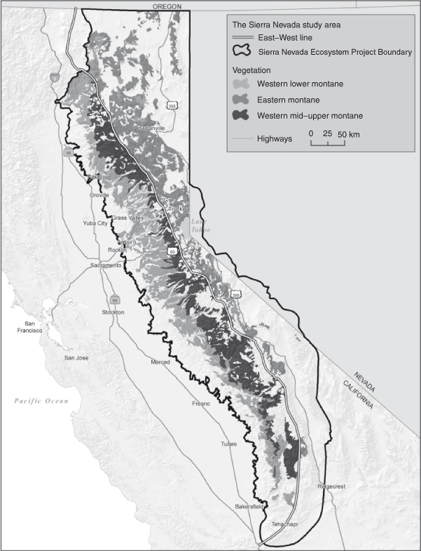
To assess high-severity fire trends since 1984, we analysed the entire region covered by the Sierra Nevada Ecosystem Project (SNEP 1996). This area includes all of the Sierra Nevada and southern Cascade mountains within California (Fig. 1). We limited our analyses to forest vegetation of the western lower, mid–upper and eastern montane forests of the study landscape. These forests were identified by overlaying 1977 vegetation (Cal–Veg, see http://www.fs.fed.us/r5/rsl/projects/classification/zone-map.shtml, accessed 25 January 2013) (Franklin et al. 2000) because of the necessity of including all forest present before available fire severity mapping beginning in 1984.
|
Lower montane forests of the study area are dominated by conifers, including ponderosa pine (Pinus ponderosa Dougl. ex. Laws), Douglas-fir (Pseudotsuga menziesii (Mirb.) Franco), white fir (Abies concolor (Gord. and Glend.) Hildebr.), incense-cedar (Calocedrus decurrens (Torr.) Florin), sugar pine (Pinus lambertiana Dougl.) and mixed and interspersed with the broadleaved deciduous California black oak (Quercus kelloggii Newb.) and evergreen canyon live oak (Quercus chysolepsis Liebm.) (Barbour et al. 2007). We used all forests where the Cal–Veg association was ponderosa pine or mixed conifer-pine (mixed-conifer forest dominated by ponderosa pine) to comprise the western lower montane forest zone.
Mid–upper montane forests are those dominated by white fir, red fir (Abies magnifica A. Murr.), Jeffrey pine (Pinus jeffreyi Grev. & Balf.), sugar pine and lodgepole pine (Pinus contorta Dougl. ex. Loud), which can be mixed with western white pine (Pinus monticola Dougl. ex. D. Don.) and mountain hemlock (Tsuga mertensiana (Bong.) Carr.) (Barbour et al. 2007). This forest zone was identified by selecting areas where the Cal–Veg association was mixed conifer–fir (mixed-conifer forest dominated by white fir), white fir, red fir, Jeffrey pine and lodgepole pine.
Eastern montane forests are comprised of the forest types found in the western mid–upper montane zone, but are located east of the Sierra–Cascade crest and are dominated by Jeffrey pine, occasionally mixed with singleleaf pinyon pine (Pinus monophylla Torr. & Frem.), and western juniper (Juniperus occidentalis Hook. and subsp. australis) east of the crest and in the transition area near the crest (Barbour et al. 2007). We identified this forest zone by selecting Jeffrey pine, ponderosa pine, mixed conifer, white fir, red fir and lodgepole pine Cal–Veg associations east of the Sierra–Cascade crest (Fig. 1).
Mid–upper western montane forests and eastern montane forest zones are distinguished from lower western montane forests in that the majority of annual precipitation falls as snow, rather than as rain. The eastern montane forest zone is distinguished from western montane forests by substantially lower annual precipitation on the east side, resulting from the rain shadow created by the Sierra–Cascade crest (Barbour et al. 2007).
Identification of forests that burned using vegetation maps
As an initial matter, we assessed the suitability of current post-burn mapping for our analysis. Using the same trend test approach described below in ‘Statistical analyses’, we assessed whether use of maps of potential conifer forest that post-dated most fires (current mapping from Cal–Veg and Landfire see http://www.fs.fed.us/r5/rsl/projects/classification/zone-map.shtml, accessed 25 January 2013, and http://www.landfire.gov/, accessed 18 January 2013) tend to exclude (i.e. map as non-conifer vegetation) relatively more montane conifer forest experiencing high-severity fire in the earlier years of the time series than in the later years. To test the accuracy of the 1977 Cal–Veg dataset, which pre-dates our time series, we determined the percentage of the 1317 US Forest Service Forest Inventory and Analysis (FIA) plots (http://www.fia.fs.fed.us/tools-data/) in our study area that had forest types matching the three montane forest zones in our study, as described above.
Contemporary high-severity fire
To investigate current high-severity fire trends, we used all 1984–2010 fire severity data, from satellite imagery, available from the US Government’s program, Monitoring Trends in Burn Severity (MTBS) (http://www.mtbs.cr.usgs.gov/). These data are based on the Relative delta Normalised Burn Ratio (RdNBR), which adjusts for differing pre-fire vegetation (Miller et al. 2009), and compares reflectance from pre-fire vegetation to reflectance at one year post-fire (Miller and Thode 2007). RdNBR data are not gathered for fires <405 ha and, thus are not available. These fires comprised 7.2% of the total area burned, which we determined by comparing the total area of forest with fire severity data in our study area to the total area within all fire perimeters provided by Cal Fire’s Fire and Resource Assessment Program, or ‘FRAP’, which contains a comprehensive database of fire perimeters of all sizes from incident reports (http://www.frap.cdf.ca.gov). To quantify the extent of high-severity fire we used an RdNBR threshold of 641 (Miller and Thode 2007), which translates to ~70% mortality of the pre-fire live basal area in montane forests of the Sierra Nevada, based upon data from US Forest Service field validation plots that assessed basal area mortality at various RdNBR levels (Hanson et al. 2010).
Statistical analyses
We used the non-parametric Mann–Kendall trend test (Sokal and Rohlf 1995) to determine whether mapping and fire severity trends existed from 1984–2010. We used this test because the data did not meet the normality assumptions for parametric analyses, the Mann–Kendall test was the most parsimonious test for our univariate hypotheses, and can detect non-linear trends (Önöz and Bayazit 2003). This test is widely used to detect trends over time in environmental data (Önöz and Bayazit 2003; Yue and Hashino 2003; Xiong and Guo 2004), including fire severity trend analyses in conifer forests (Hanson et al. 2009). The Mann–Kendall trend test tends to have better statistical power for data that are not normally distributed, including data with high variance in a relatively short time series (Yue et al. 2002, figs 7, 8; Önöz and Bayazit 2003), performing ‘either as well or better’ than parametric regressions for non-normal data (Helsel and Hirsch 2002), such as the data at issue in this study.
Within the Sierra Nevada region as broadly defined by SNEP (1996), we tested for trends in annual high-severity proportion and area in each of the three forest zones (lower western montane, mid-upper western montane and eastern montane), with the year as the independent variable and annual proportion of high-severity fire effects (high-severity fire hectares divided by total fire hectares) or annual hectares of high-severity fire as the dependent variables. We also tested for trends in mean and maximum high-severity patch size across the study area, with the year as the independent variable and annual mean high-severity fire patch size or annual maximum high-severity patch size as the dependent variables. For the annual mean high-severity patch size, the minimum patch was the pixel (30 × 30 m), and each group of contiguous high-severity pixels was analysed as a separate patch for the purposes of calculating the annual mean high-severity patch size from 1984–2010. In each analysis, an individual year was the unit of replication. For each time series we tested for autocorrelation using the methods described in Xiong and Guo (2004). In addition, we calculated the rotation for high-severity fire from 1984–2010 in the different forest zones. Fire rotation is the amount of time needed to burn an area equal to the area of interest one time (Heinselman 1973).
Results
Both current Cal–Veg and current Landfire mapping of potential vegetation excluded significantly greater proportions of the areas that were mapped as montane conifer forest by 1977 Cal–Veg, and that experienced high-severity fire, in the earlier years of the time series relative to the later years (Current Cal–Veg: z = –1.96, P = 0.025; Current Landfire: z = –2.04, P = 0.021). This effect causes an upward trend in fire severity within montane conifer forest even when such a trend does not actually exist. Because of the trend introduced by mapping that post-dated most fires, we undertook no further analyses using this mapping and relied instead on the pre-burn map: 1977 Cal–Veg. We found that this map was reasonably accurate. The consistency between 1977 Cal–Veg data and FIA data was 88.1, 87.9 and 85.3% for lower western montane, mid–upper western montane and eastern montane zones.
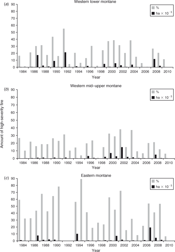
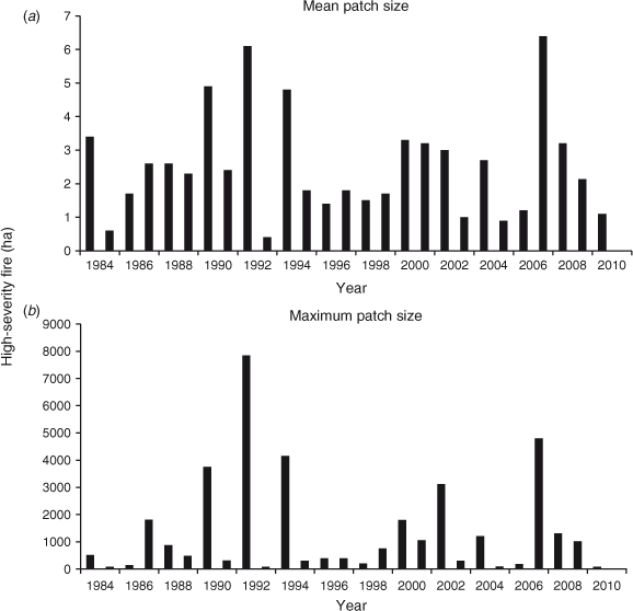
We analysed a total cumulative post-fire area of 608 815 ha of conifer forests as identified by Cal–Veg 1977 for the period 1984–2010. There was no significant trend over this time in high-severity fire proportion in western lower montane (z = –0.46, P = 0.646), western mid–upper montane (z = –0.88, P = 0.379) or eastern montane forests since 1984 (z = –1.71, P = 0.087) (Fig. 2a–c). There was no trend in annual area of high-severity fire in western lower montane (z = 0.00, P = 1.00), western mid–upper montane (z = 1.17, P = 0.242) or eastern montane forests (z = 0.71, P = 0.478) (Fig. 2a–c). Nor was there any trend in high-severity fire mean annual patch size (z = –0.625, P = 0.529) or maximum annual patch size (z = 0.17, P = 0.865) (Fig. 3a–b). None of the time series were autocorrelated.
|
|
Rotations for high-severity fire of 461, 893 and 714 years were found in western lower montane, western mid–upper montane and eastern montane forests.
Discussion
Our results represent the first quantitative analysis of high-severity fire in the Sierra Nevada region using the most complete and spatially extensive fire severity dataset (MTBS), and covering all lands. We found no evidence that contemporary high-severity fires have increased in proportion, area or patch size since 1984.
Our findings likely differ from those of Miller et al. (2009) and Miller and Safford (2012) because we used vegetation mapping that pre-dated the time series. We found that using vegetation mapping that post-dated the time series introduced a significant, phantom trend of increasing fire severity because of the effect in excluding high-severity fire early in the time series. This supports the hypothesis of Miller et al. (2012) that using vegetation maps that pre-date burn severity data will avoid such error. This is an important methodological consideration for assessing trends in burn severity.
A second reason for differences between our findings and previous findings is that we used the national MTBS fire severity dataset, which is more spatially extensive in its coverage of fires than the regional data (http://www.fs.usda.gov/main/r5/landmanagement/gis, accessed 25 January 2013) used in those analyses, which covers ‘most’, but not all, fires occurring partially on national forest lands (Miller and Safford 2012), representing a ‘subset’ of such fires (Miller et al. 2009). The MTBS data we used included considerably more total burned area within conifer forests (1984–2010) than the regional dataset (Miller and Safford 2012). Our analysis using MTBS data covered 608 815 ha of burned area, compared with 490 277 ha in Miller et al. (2009) and 318 192 ha in Miller and Safford (2012); the relative proportions of federal lands (78%) v. private lands (20%) in these studies were nearly identical to the proportions in our analysis (79% federal lands v. 20% private). Thus, the relative proportions of national forest lands, other federal lands or private lands would not account for differences in findings.
The MTBS dataset includes, in particular, better coverage of smaller or average fire years in the earlier years of the time series. For example, the smallest fire years in the analysis of high-severity fire area in Miller and Safford (2012) were all in the earlier years of the time series, showing values of 0 to ~70 ha of high-severity fire in ponderosa pine and mixed-conifer forests per year in e.g. 1986, 1991, 1995 and 1998 (corresponding to log-transformed values of 0 to 1.85, or extreme low values, in Miller and Safford 2012). In contrast, the MTBS data in our analysis indicates ~400 to 1000 ha of high-severity fire in these forest types in each of these years, corresponding to log-transformed values of 2.6 to 3.0, or average values, in fig. 3 of Miller and Safford (2012). Similarly, the use of a spatially less-extensive regional data approach can exclude particularly large, severe fires in the earlier years of the time series, such as the Fountain fire of 1992 (over 20 000 ha of high-severity fire in ponderosa pine and mixed-conifer forest), which occurred mostly on private lands, but partially on national forest lands, within the Sierra Nevada Forest Plan Amendment management area, but was not included in the Miller and Safford (2012) analysis. It is because the MTBS dataset has the best coverage of fire areas that it has become the standard system used to evaluate fire severity trends in forests of California and elsewhere in the western USA (Hanson et al. 2009; Dillon et al. 2011; Miller et al. 2012).
There may be factors that are mitigating the effects of warming temperatures on fire behaviour. In dry fuels, wind speed is the most important factor in determining fire behaviour (Cruz et al. 2004; Cruz and Alexander 2010). Recent research indicates that with climate change, the wind speed probability distribution may be shifting towards slower winds, particularly in mid-latitudes (Pryor and Barthelmie 2010; Pryor and Ledolter 2010). Pryor and her colleagues found that wind speeds appear to be waning in most of the USA, in many locations by more than 1% per year. Decreases in wind climate may be disproportionately important because of the exponential relationship between wind speed and fire intensity (Byram 1959; Albini and Baughman 1979). However, an analysis of trends in wind climate in the Sierra Nevada region is needed to determine whether the broader trends in the USA apply there as well.
In relatively productive vegetation, fire activity is strongly influenced, inversely, by fuel moisture, which in turn may be controlled by drought and precipitation patterns (Meyn et al. 2007; Krawchuk and Moritz 2011). Though precipitation appears to have increased over the past several decades in Sierra Nevada forests (Crimmins et al. 2011; North 2012, fig. 3-1), consistent with many global climate model predictions for the Pacific Northwest, USA (Mote and Salathé 2010), precipitation patterns within the shorter time period of our study have been more variable, especially over the latitudinal gradient of the study area. More research is needed to understand how high-severity fire occurrence is affected by the level and seasonality of precipitation, and by the influence of precipitation on pyrogenic vegetation (Parisien and Moritz 2009).
In addition to climate, the effects of fire suppression have been assumed to have caused a trend of increasingly severe fire (Miller et al. 2009). However, Odion and Hanson (2006, 2008) and van Wagtendonk et al. (2012) found that fire severity in Sierra Nevada forests did not increase significantly as a function of a metric (Condition Class) for the magnitude of fire suppression. In fact, in the more extensive fires studied, fire severity tended to decrease with very long fire intervals (Odion and Hanson 2006, 2008). This is supported by recent research on flammability trends in Sierran forests by Schwilk and Caprio (2011). In addition, in the dry forest types in the interior north-west California, which range from open to closed canopy, Miller et al. (2012) found modest amounts of high-severity fire that did not differ in long-unburned forests relative to more recently burned forests and, in moister closed forests of this region, fire severity decreased with time since fire, consistent with earlier research (Odion et al. 2004, 2010; Miller et al. 2012).
Because fire severity has been mostly low and moderate (Fig. 2a–c), and fires relatively infrequent due to fire suppression, the rotation for high-severity fire since 1984 at the bioregional scale of the Sierra Nevada was a relatively long 645 years. This is longer than rotations before the influence of fire suppression based on available research that allows calculations of historic rotations. Bekker and Taylor (2001), in a remote unmanaged area of mixed-conifer and upper montane forest in the southern Cascades of California, within our study area, found that 50–60% of these forests experienced high-severity fire over a 76-year period before effective fire suppression. Baker (2012), using US Government field plot data from the mid-late 1800s, found a high-severity fire rotation of 435 years in dry mixed-conifer forests of the eastern Cascades of Oregon, adjacent to our study area. Minnich et al. (2000) studied fire severity patterns in mixed-conifer forests of northern Baja California, Mexico within an area that had not been logged or subjected to fire suppression. In these forests, Minnich et al. (2000) found a natural high-severity fire rotation of 300 years. In a modelling study reconstructing historic fire patterns, Stephens et al. (2007) estimated a high-severity fire rate, before 1850, of 5% every 12 to 20 years for ponderosa pine and mixed-conifer forests of the Sierra Nevada (rotation of 240 to 400 years), and shorter rotations for upper montane fir forests. In another study (Collins and Stephens 2010), an average of 15% high-severity fire was found in reference mixed-conifer forests with overall fire frequencies that were similar to those used in Stephens et al. (2007), suggesting similar, or slightly shorter, high-severity fire rotations relative to those modelled in Stephens et al. (2007).
Conclusion
Our results highlight the need to use vegetation mapping from before high-severity fire occurs to identify patterns of such fire. Using such a map, we found that the occurrence of high-severity fire does not appear to be increasing in recent decades. High-severity fire remains a significant but minor proportion of overall fire effects that has been reduced by fire suppression. This suggests a need for thoughtful assessment of fire management priorities, which often cite problems of increasing fire severity and amounts that are assumed to be excessive compared with historical amounts (Stephens and Ruth 2005; Spencer et al. 2008; Scheller et al. 2011; Syphard et al. 2011; Thompson et al. 2011). For example, management is often aimed at improving fire suppression effectiveness and reducing fire behaviour in forested landscapes (Collins et al. 2010; Moghaddas et al. 2010) v. focussing immediately adjacent to human communities (Schoennagel et al. 2009; Schoennagel and Nelson 2011).
Finally, our results suggest that predictions that there will be ample, or excessive, high-severity fire, and plenty of suitable habitat for biota dependent on natural early-successional conditions created by fire (Stephens and Ruth 2005), or a diversity of vegetation age classes created by high-severity fire, may be incorrect. Post-fire early-successional habitat appears to be an important conservation priority, but it is not protected as such (Hanson and North 2008; Hutto 2006, 2008). Moreover, many natural forests have been replaced by even-aged, single species tree plantations or modified by silvicultural activities so that they will not function as post-burn habitat for some species (Hutto 2008). Increased recognition of the relative scarcity and ecological importance of burned forest habitats can improve protection of β diversity (Lindenmayer and Franklin 2002; Lindenmayer et al. 2004; Swanson et al. 2011).
Acknowledgements
Thanks are due to Tim Sinnott of GreenInfo Network for the GIS layering, and Hugh Safford of the USDA Forest Service for the line used to divide the eastern and western Sierra Nevada.
References
Agee JK, Skinner CN (2005) Basic principles of forest fuel reduction treatments. Forest Ecology and Management 211, 83–96.| Basic principles of forest fuel reduction treatments.Crossref | GoogleScholarGoogle Scholar |
Albini FA, Baughman RG (1979) Estimating windspeeds for predicting wildland fire behavior. USDA Forest Service, Intermountain Forest and Range Experiment Station, Research Paper INT-221. (Ogden, UT)
Baker WL (2012) Implications of spatially extensive historical data from surveys for restoring dry forests of Oregon’s eastern Cascades. Ecosphere 3, art23
| Implications of spatially extensive historical data from surveys for restoring dry forests of Oregon’s eastern Cascades.Crossref | GoogleScholarGoogle Scholar |
Barbour MG, Keeler-Wolf T, Schoenherr AA, eds. (2007) ‘Terrestrial Vegetation of California’, 3rd edn. (University of California Press: Berkeley, CA)
Bekker MF, Taylor AH (2001) Gradient analysis of fire regimes in montane forests of the southern Cascade Range, Thousand Lakes Wilderness, California, USA. Plant Ecology 155, 15–28.
| Gradient analysis of fire regimes in montane forests of the southern Cascade Range, Thousand Lakes Wilderness, California, USA.Crossref | GoogleScholarGoogle Scholar |
Bond WJ, Woodward FI, Midgley GF (2005) The global distribution of ecosystems in a world without fire. New Phytologist 165, 525–538.
| The global distribution of ecosystems in a world without fire.Crossref | GoogleScholarGoogle Scholar | 1:STN:280:DC%2BD2M%2Fpt1OktQ%3D%3D&md5=687c363d2615eb1e90fe91aa284fa5e7CAS | 15720663PubMed |
Byram GM (1959) Combustion of forest fuels. In ‘Forest Fire: Control and Use’. (Ed. KP Davis) pp. 61–89, 554–555. (McGraw-Hill: New York)
Collins BM, Stephens SL (2010) Stand-replacing patches within a mixed-severity fire regime: quantitative characterization using recent fires in a long-established natural fire area. Landscape Ecology 25, 927–939.
| Stand-replacing patches within a mixed-severity fire regime: quantitative characterization using recent fires in a long-established natural fire area.Crossref | GoogleScholarGoogle Scholar |
Collins BM, Thode AE, Kelly M, van Wagtendonk JW, Stephens SL (2009) Interactions among wildland fires in a long-established Sierra Nevada natural fire area. Ecosystems 12, 114–128.
| Interactions among wildland fires in a long-established Sierra Nevada natural fire area.Crossref | GoogleScholarGoogle Scholar |
Collins BM, Stephens SL, Moghaddas JJ, Battles J (2010) Challenges and approaches in planning fuel treatments across fire-excluded forested landscapes. Journal of Forestry 108, 24–31.
Crimmins SM, Dobrowski SZ, Greenberg JA, Abatzoglou JT, Mynsberge AR (2011) Changes in water balance drive downhill shifts in plant species’ optimum elevations. Science 331, 324–327.
| Changes in water balance drive downhill shifts in plant species’ optimum elevations.Crossref | GoogleScholarGoogle Scholar | 1:CAS:528:DC%2BC3MXmsVeqtQ%3D%3D&md5=149a7a13bd95c12e5c76a657826d88f2CAS | 21252344PubMed |
Cruz MG, Alexander ME (2010) Assessing crown fire potential in coniferous forests of western North America: a critique of current approaches and recent simulation studies. International Journal of Wildland Fire 19, 377–398.
| Assessing crown fire potential in coniferous forests of western North America: a critique of current approaches and recent simulation studies.Crossref | GoogleScholarGoogle Scholar |
Cruz MG, Alexander ME, Wakimoto RH (2004) Modeling the likelihood of crown fire occurrence in conifer forest stands. Forest Science 50, 640–658.
Dillon GK, Holden ZA, Morgan P, Crimmins MA, Heyerdahl EK, Luce CH (2011) Both topography and climate affected forest and woodland burn severity in two regions of the western US, 1984 to 2006. Ecosphere 2, art130
| Both topography and climate affected forest and woodland burn severity in two regions of the western US, 1984 to 2006.Crossref | GoogleScholarGoogle Scholar |
Franklin J, Woodcock CE, Warbington R (2000) Multi-attribute vegetation maps of forest service lands in California supporting resource management decisions. Photogrammetric Engineering and Remote Sensing 66, 1209–1217.
Hanson CT, North MP (2008) Postfire woodpecker foraging in salvage-logged and unlogged forests of the Sierra Nevada. The Condor 110, 777–782.
| Postfire woodpecker foraging in salvage-logged and unlogged forests of the Sierra Nevada.Crossref | GoogleScholarGoogle Scholar |
Hanson CT, Odion DC, DellaSala DA, Baker WL (2009) Overestimation of fire risk in Northern Spotted Owl Recovery Plan. Conservation Biology 23, 1314–1319.
| Overestimation of fire risk in Northern Spotted Owl Recovery Plan.Crossref | GoogleScholarGoogle Scholar | 19549218PubMed |
Hanson CT, Odion DC, DellaSala DA, Baker WL (2010) More-comprehensive recovery actions for Northern Spotted Owls in dry forests: reply to Spies et al. Conservation Biology 24, 334–337.
| More-comprehensive recovery actions for Northern Spotted Owls in dry forests: reply to Spies et al.Crossref | GoogleScholarGoogle Scholar |
He HS, Mladenoff DJ (1999) Spatially explicit and stochastic simulation of forest-landscape fire disturbance and succession. Ecology 80, 81–99.
| Spatially explicit and stochastic simulation of forest-landscape fire disturbance and succession.Crossref | GoogleScholarGoogle Scholar |
Heinselman ML (1973) Fire in the virgin forests of the Boundary Waters Canoe Area, Minnesota. Quaternary Research 3, 329–382.
| Fire in the virgin forests of the Boundary Waters Canoe Area, Minnesota.Crossref | GoogleScholarGoogle Scholar |
Helsel DR, Hirsch RM (2002) Chapter A3. Statistical methods in water resources. In ‘Book 4, Hydrologic Analysis and Interpretation. Techniques of Water-Resources Investigations of the United States Geological Survey’. (US Geological Survey: Washington, DC)
Hutto RL (2006) Toward meaningful snag-management guidelines for postfire salvage logging in North American conifer forests. Conservation Biology 20, 984–993.
| Toward meaningful snag-management guidelines for postfire salvage logging in North American conifer forests.Crossref | GoogleScholarGoogle Scholar | 16922215PubMed |
Hutto RL (2008) The ecological importance of severe wildfires: some like it hot. Ecological Applications 18, 1827–1834.
| The ecological importance of severe wildfires: some like it hot.Crossref | GoogleScholarGoogle Scholar | 19263880PubMed |
Krawchuk MA, Moritz MA (2011) Constraints on global fire activity vary across a resource gradient. Ecology 92, 121–132.
| Constraints on global fire activity vary across a resource gradient.Crossref | GoogleScholarGoogle Scholar | 21560682PubMed |
Lindenmayer DB, Franklin JF (2002) ‘Conserving Forest Biodiversity.’ (Island Press: Washington, DC)
Lindenmayer DB, Foster DR, Franklin JF, Hunter ML, Noss RF, Schmiegelow FA, Perry D (2004) Salvage harvesting policies after natural disturbance. Science 303, 1303
| Salvage harvesting policies after natural disturbance.Crossref | GoogleScholarGoogle Scholar | 1:CAS:528:DC%2BD2cXhslCrt78%3D&md5=7ce52d7c81bd5a63ec3252022d686444CAS | 14988539PubMed |
Littell JS, McKenzie D, Peterson DL, Westerling AL (2009) Climate and wildfire area burned in western US ecoprovinces, 1916-2003. Ecological Applications 19, 1003–1021.
| Climate and wildfire area burned in western US ecoprovinces, 1916-2003.Crossref | GoogleScholarGoogle Scholar | 19544740PubMed |
Meyn A, White PS, Buhk C, Jentsch A (2007) Environmental drivers of large infrequent wildfires: the emerging conceptual model. Progress in Physical Geography 31, 287–312.
| Environmental drivers of large infrequent wildfires: the emerging conceptual model.Crossref | GoogleScholarGoogle Scholar |
Miller JD, Safford HD (2012) Trends in wildfire severity: 1984 to 2010 in the Sierra Nevada, Modoc Plateau, and southern Cascades, California, USA. Fire Ecology 8, 41–57.
| Trends in wildfire severity: 1984 to 2010 in the Sierra Nevada, Modoc Plateau, and southern Cascades, California, USA.Crossref | GoogleScholarGoogle Scholar |
Miller JD, Thode AE (2007) Quantifying burn severity in a heterogeneous landscape with a relative version of the delta Normalized Burn Ratio (dNBR). Remote Sensing of Environment 109, 66–80.
| Quantifying burn severity in a heterogeneous landscape with a relative version of the delta Normalized Burn Ratio (dNBR).Crossref | GoogleScholarGoogle Scholar |
Miller JD, Safford HD, Crimmins M, Thode AE (2009) Quantitative evidence for increasing forest fire severity in the Sierra Nevada and southern Cascade Mountains, California and Nevada, USA. Ecosystems 12, 16–32.
| Quantitative evidence for increasing forest fire severity in the Sierra Nevada and southern Cascade Mountains, California and Nevada, USA.Crossref | GoogleScholarGoogle Scholar |
Miller JD, Skinner CN, Safford HD, Knapp EE, Ramirez CM (2012) Trends and causes of severity, size, and number of fires in northwestern California, USA. Ecological Applications 22, 184–203.
| Trends and causes of severity, size, and number of fires in northwestern California, USA.Crossref | GoogleScholarGoogle Scholar | 1:STN:280:DC%2BC38rhvVamtg%3D%3D&md5=8b06d0fdb457dc41205446b6875ce3ebCAS | 22471083PubMed |
Minnich RA, Barbour MG, Burk JH, Sosa-Ramirez J (2000) Californian mixed-conifer forests under unmanaged fire regimes in the Sierra San Pedro Martir, Baja California, Mexico. Journal of Biogeography 27, 105–129.
| Californian mixed-conifer forests under unmanaged fire regimes in the Sierra San Pedro Martir, Baja California, Mexico.Crossref | GoogleScholarGoogle Scholar |
Moghaddas JJ, Collins BM, Menning K, Moghaddas EEY, Stephens SL (2010) Fuel treatment effects on modeled landscape-level fire behavior in the northern Sierra Nevada. Canadian Journal of Forest Research 40, 1751–1765.
| Fuel treatment effects on modeled landscape-level fire behavior in the northern Sierra Nevada.Crossref | GoogleScholarGoogle Scholar |
Mote P, Salathé EP (2010) Future climate in the Pacific Northwest. Climatic Change 102, 29–50.
| Future climate in the Pacific Northwest.Crossref | GoogleScholarGoogle Scholar |
Nagel TA, Taylor AH (2005) Fire and persistence of montane chaparral in mixed conifer forest landscapes in the northern Sierra Nevada, Lake Tahoe Basin, California, USA. The Journal of the Torrey Botanical Society 132, 442–457.
| Fire and persistence of montane chaparral in mixed conifer forest landscapes in the northern Sierra Nevada, Lake Tahoe Basin, California, USA.Crossref | GoogleScholarGoogle Scholar |
North MP, ed. (2012) Managing Sierra Nevada forests. USDA Forest Service, Pacific Southwest Research Station, General Technical Report PSW-GTR-237. (Albany, CA)
Odion DC, Hanson CT (2006) Fire severity in conifer forests of the Sierra Nevada, California. Ecosystems 9, 1177–1189.
| Fire severity in conifer forests of the Sierra Nevada, California.Crossref | GoogleScholarGoogle Scholar |
Odion DC, Hanson CT (2008) Fire severity in the Sierra Nevada revisited: conclusions robust to further analysis. Ecosystems 11, 12–15.
| Fire severity in the Sierra Nevada revisited: conclusions robust to further analysis.Crossref | GoogleScholarGoogle Scholar |
Odion DC, Strittholt JR, Jiang H, Frost EJ, DellaSala DA, Moritz MA (2004) Patterns of fire severity and forest conditions in the Western Klamath Mountains, California. Conservation Biology 18, 927–936.
| Patterns of fire severity and forest conditions in the Western Klamath Mountains, California.Crossref | GoogleScholarGoogle Scholar |
Odion DC, Moritz MA, DellaSala DA (2010) Alternative community states maintained by fire in the Klamath Mountains, USA. Journal of Ecology 98, 96–105.
| Alternative community states maintained by fire in the Klamath Mountains, USA.Crossref | GoogleScholarGoogle Scholar |
Önöz B, Bayazit M (2003) The power of statistical tests for trend detection. Turkish Journal of Environmental Science 27, 247–251.
Parisien M, Moritz MA (2009) Environmental controls on the distribution of wildfire at multiple spatial scales. Ecological Monographs 79, 127–154.
| Environmental controls on the distribution of wildfire at multiple spatial scales.Crossref | GoogleScholarGoogle Scholar |
Pryor SC, Barthelmie RJ (2010) Climate change impacts on wind energy: a review. Renewable & Sustainable Energy Reviews 14, 430–437.
| Climate change impacts on wind energy: a review.Crossref | GoogleScholarGoogle Scholar |
Pryor SC, Ledolter J (2010) Addendum to: Wind speed trends over the contiguous USA. Journal of Geophysical Research 115, D10103
| Addendum to: Wind speed trends over the contiguous USA.Crossref | GoogleScholarGoogle Scholar |
Scheller RM, Spencer WD, Rustigian-Romsos H, Syphard AD, Ward BC, Strittholt JR (2011) Using stochastic simulation to evaluate competing risks of wildfires and fuels management on an isolated forest carnivore. Landscape Ecology 26, 1491–1504.
| Using stochastic simulation to evaluate competing risks of wildfires and fuels management on an isolated forest carnivore.Crossref | GoogleScholarGoogle Scholar |
Schoennagel T, Nelson CR (2011) Restoration relevance of recent National Fire Plan treatments in forests of the western United States. Frontiers in Ecology and the Environment 9, 271–277.
| Restoration relevance of recent National Fire Plan treatments in forests of the western United States.Crossref | GoogleScholarGoogle Scholar |
Schoennagel T, Nelson CR, Theobald DM, Carnwath GC, Chapman TB (2009) Implementation of National Fire Plan fuel treatments near the wildland–urban interface in the western US. Proceedings of the National Academy of Sciences of the United States of America 106, 10 706–10 711.
| Implementation of National Fire Plan fuel treatments near the wildland–urban interface in the western US.Crossref | GoogleScholarGoogle Scholar | 1:CAS:528:DC%2BD1MXos1ajsbc%3D&md5=8f6ff1174dfd1e27507f63740a79a166CAS |
Schwilk DW, Caprio A (2011) Scaling from leaf traits to fire behaviour: community composition predicts fire severity in a temperate forest. Journal of Ecology 99, 970–980.
| Scaling from leaf traits to fire behaviour: community composition predicts fire severity in a temperate forest.Crossref | GoogleScholarGoogle Scholar |
Schwind B (Ed.) (2008) Monitoring trends in burn severity: report on the Pacific Northwest and Pacific Southwest fires (1984 to 2005). USDI, Geological Survey, Center for Earth Resources Observation and Science (Sioux Falls, SD). Available at http://www.mtbs.gov/reports/projectreports.htm [Verified 16 July 2009]
SNEP (1996) Sierra Nevada Ecosystem Project, Final Report to Congress, Vol. I. University of California at Davis, Centers for Water and Wildland Resources. (Davis, CA)
Sokal RR, Rohlf FJ (1995) ‘Biometry: the Principles and Practice of Statistics in Biological Research.’ (W.H. Freeman and Company: New York)
Spencer WD, Rustigian HL, Sheller RM, Syphard A, Strittholt J, Ward B (2008) Baseline evaluation of fisher habitat and population status, and effects of fire and fuels management on fishers in the southern Sierra Nevada. Conservation Biology Institute, Report prepared for USDA Forest Service, Pacific Southwest Region. June 2008. (Vallejo, CA) Available at http://d2k78bk4kdhbpr.cloudfront.net/media/reports/files/fisher_final_report.pdf [Verified 31 August 2013]
Stephens SL, Ruth LW (2005) Federal forest-fire policy in the United States. Ecological Applications 15, 532–542.
| Federal forest-fire policy in the United States.Crossref | GoogleScholarGoogle Scholar |
Stephens SL, Martin RE, Clinton NE (2007) Prehistoric fire area and emissions from California’s forests, woodlands, shrublands, and grasslands. Forest Ecology and Management 251, 205–216.
| Prehistoric fire area and emissions from California’s forests, woodlands, shrublands, and grasslands.Crossref | GoogleScholarGoogle Scholar |
Swanson ME, Franklin JF, Beschta RL, Crisafulli CM, DellaSala DA, Hutto RL, Lindenmayer DB, Swanson FJ (2011) The forgotten stage of forest succession: early-successional ecosystems on forest sites. Frontiers in Ecology and the Environment 9, 117–125.
| The forgotten stage of forest succession: early-successional ecosystems on forest sites.Crossref | GoogleScholarGoogle Scholar |
Syphard AD, Scheller RM, Ward BC, Spencer WD, Strittholt JR (2011) Simulating landscape-level effects of fuels treatments in the Sierra Nevada, California, USA. International Journal of Wildland Fire 20, 364–383.
| Simulating landscape-level effects of fuels treatments in the Sierra Nevada, California, USA.Crossref | GoogleScholarGoogle Scholar |
Thompson CM, Zielinski WJ, Purcell KL (2011) Evaluating management risks using landscape trajectory analysis: a case study of California Fisher. The Journal of Wildlife Management 75, 1164–1176.
| Evaluating management risks using landscape trajectory analysis: a case study of California Fisher.Crossref | GoogleScholarGoogle Scholar |
van Wagtendonk JW, van Wagtendonk KA, Thode AE (2012) Factors associated with the severity of intersecting fires in Yosemite National Park, California, USA. Fire Ecology 8, 11–31.
| Factors associated with the severity of intersecting fires in Yosemite National Park, California, USA.Crossref | GoogleScholarGoogle Scholar |
Westerling AL, Hidalgo HG, Cayan DR, Swetnam TW (2006) Warming and earlier spring increases western US forest wildfire activity. Science 313, 940–943.
| Warming and earlier spring increases western US forest wildfire activity.Crossref | GoogleScholarGoogle Scholar | 1:CAS:528:DC%2BD28XotFCitbo%3D&md5=308417c344ec067b31725c73724340afCAS | 16825536PubMed |
Xiong L, Guo S (2004) Trend test and change-point detection for the annual discharge series of the Yangtze River at the Yichang hydrological station. Hydrological Science 49, 99–112.
| Trend test and change-point detection for the annual discharge series of the Yangtze River at the Yichang hydrological station.Crossref | GoogleScholarGoogle Scholar |
Yue S, Hashino M (2003) Temperature trends in Japan: 1900–1996. Theoretical and Applied Climatology 75, 15–27.
Yue S, Pilon P, Cavadias G (2002) Power of Mann–Kendall and Spearman’s rho tests for detecting monotonic trends in hydrological series. Journal of Hydrology 259, 254–271.
| Power of Mann–Kendall and Spearman’s rho tests for detecting monotonic trends in hydrological series.Crossref | GoogleScholarGoogle Scholar |