

Space use by resident and transient coyotes in an urban–rural landscape mosaic
Numi Mitchell A F , Michael W. Strohbach B , Ralph Pratt C , Wendy C. Finn D and Eric G. Strauss EA The Conservation Agency, 67 Howland Ave, Jamestown, RI 02835, USA.
B Humboldt-Universität zu Berlin, Department of Geography, Landscape Ecology Lab, Unter den Linden 6, 10099 Berlin, Germany.
C West Greenwich Animal Hospital, 14 Victory Hwy, West Greenwich, RI 02817, USA.
D Department of Natural Resources Science, University of Rhode Island, Kingston, RI 02881, USA.
E Loyola Marymount University Center for Urban Resilience, 1 LMU Drive, Los Angeles, CA 90045, USA.
F Corresponding author. Email: numimitchell@gmail.com
Wildlife Research 42(6) 461-469 https://doi.org/10.1071/WR15020
Submitted: 2 February 2015 Accepted: 15 August 2015 Published: 28 September 2015
Journal Compilation © CSIRO Publishing 2015 Open Access CC BY-NC-ND
Abstract
Context: Coyotes (Canis latrans) have adapted successfully to human landscape alteration in the past 150 years and in recent decades have successfully moved into urban areas. While this causes concern about human–wildlife conflicts, research also suggests that coyotes tend to avoid humans and human activity in urban areas. For improving management, a better understanding of space use by coyotes is needed.
Aims: To study how coyote social behaviour influences fine-scale space use in urban areas we present results from an extensive, multi-year GPS telemetry study (2005–13). The study area in coastal Rhode Island is a mosaic of rural, suburban and urban land use and coyotes have only recently arrived.
Methods: We differentiated between two social classes: residents (individuals that have established a territory; n = 24) and transients (individuals that have no territory; n = 7). Space use was analysed using mixed effect models and detailed land-cover data.
Key results: Coyotes tended to select for agricultural and densely vegetated land cover and against land used for housing and commerce. Pasture and cropland were preferred by residents and avoided by transients, especially at night, indicating the role of agricultural land as prime foraging habitat. Both groups selected densely vegetated land cover for daytime shelter sites. Transients selected for densely vegetated land cover both day and night, indicating use for both shelter and foraging. Resident coyotes avoided high- and medium-density housing more than transients.
Conclusions: We interpret land-cover selection by resident coyotes as indicative of coyote habitat preference, while transients more often occupied marginal habitats that probably do not reflect their preferences. Differences in land cover selection between residents and transients suggest that transients have a corollary strategy to avoid residents.
Implications: With cover and food appearing to be important drivers of space use, coexistence strategies can build on controlling food resources as well as on the tendency of coyotes to avoid humans. Nevertheless, transients, having the need to avoid territorial resident coyotes as well, show a reduced aversion to land cover with high human activity, creating a higher potential for human–wildlife conflicts.
Additional keywords: Canis latrans, GPS telemetry, human–wildlife interaction, resource selection, Rhode Island, suburban, urban.
Introduction
Around the world, mid-sized predators such as red fox (Vulpes vulpes), dingo (Canis lupus dingo), raccoon (Procyon lotor) or coyote (Canis latrans) are increasingly successful at exploiting urban areas (Bateman and Fleming 2012; Allen et al. 2013). Coyotes in particular have demonstrated their great ability to adapt to and explore resources from human-dominated landscapes by expanding their range to large parts of North America over the past 150 years and into urban areas in recent decades (Bekoff 1977; Gompper 2002; Gehrt 2007; Bateman and Fleming 2012).
The appearance of mid-sized predators in human-dominated landscapes has raised many questions regarding their impacts on human health and safety and resulted in a public demand for information on populations and wildlife management practices (Gloor et al. 2001; Gompper 2002; Gehrt et al. 2009; Bateman and Fleming 2012; Allen et al. 2013; Poessel et al. 2013; Magle et al. 2014a). For coyotes, human–wildlife conflicts mostly concern threatening behaviour or attacks on pets and sometimes even people (White and Gehrt 2009; Poessel et al. 2013). Most incidents occur close to housing areas (White and Gehrt 2009), despite evidence that coyotes generally avoid areas of high human usage (Gibeau 1998; Riley et al. 2003; Atwood et al. 2004; Gehrt et al. 2009; Gehrt et al. 2011; Gese et al. 2012; Magle et al. 2014b). An observed shift from crepuscular to nocturnal activity of urban compared to rural coyotes also hints that there is temporal avoidance of human activity (Grinder and Krausman 2001; Riley et al. 2003; Way et al. 2004; Gehrt et al. 2011). If coyotes tend to avoid human activity, why are they regularly observed in human settlements?
The answer depends on the scale at which the question is asked, because animals show very different preferences for resources within the area they live (Johnson 1980). The preference of animals for resources like habitat is commonly estimated by comparing usage of resources (e.g. certain habitat) with total availability (Manly 2002). The process in which an animal chooses to use a resource is called resource selection, but because usage can be constrained by several factors, such as competition or predation, it does not necessarily reflect preference (Johnson 1980). The largest scale of resource selection is called first-order selection, i.e. ‘the physical or geographic range of a species’. In the case of coyotes this currently includes most of North America. The next levels, second-order selection – ‘the home-range of an individual or social group’ – and third-order selection – the ‘usage made of various habitat components within the home range’ (Johnson 1980) – are most important to human communities coexisting with coyotes.
Interpreting the aforementioned body of literature suggests that, like other successful mid-sized predators, coyotes show no general avoidance of humans at second-order scale, but do at third-order scale. Often, coyotes cross quickly through areas of high human activity to reach undeveloped patches in which they do spend more time (Atwood et al. 2004; Gehrt et al. 2011; Gese et al. 2012). Murray et al. (2015) found that coyotes infested with sarcoptic mange relied more heavily on anthropogenic food sources than animals without disease. Where natural prey is abundant, conflicts with humans were found to be less likely (Magle et al. 2014a). This suggests that, given the choice, coyotes avoid humans and anthropogenic resources.
Intraspecific competition and social behaviour also influence coyote space use. Gese et al. (2012) suggest that coyotes in highly urbanised areas are forced to live there because rural territories are occupied. The same could be true for individuals that don’t defend a territory, hereafter referred to as transients. In a study on a military reservation in Kansas, Kamler and Gipson (2000) observed that transient coyotes used built areas, whereas residents (i.e. individuals that defend a territory) did not. In addition, transient coyotes can often be found at the edges of resident territories (Windberg and Knowlton 1988; Kamler and Gipson 2000; Hinton et al. 2015). In Chicago, transients tend to have a higher share of urbanised land in their home range than residents (Newsome et al. 2015). Because transient resource selection is constrained by residents that defend territories, their selection is less likely to be an expression of the true preference of the species (Kamler and Gipson 2000; Kamler et al. 2005; Hinton et al. 2015). Transients have been found to range over larger areas than residents (e.g. Gese et al. 1988; Hinton et al. 2015); suggesting they need to cover much larger areas to meet their resource needs.
In this paper, we study space use of resident and transient coyotes on Aquidneck and Conanicut islands, Rhode Island. We used detailed digital land cover/land use data (RIGIS 2014) in a third-order selection analysis. For simplicity, we will use the term ‘land cover’ rather than ‘land cover/land use’, acknowledging that they are not exact synonyms. The land-cover data, which included both natural habitats and anthropogenic cover classes, allowed us to study how human land use influences coyotes. We analysed GPS telemetry data from resident and transient coyotes. We used generalised linear and mixed effect models to estimate selection of land-cover classes for day and night separately. We hypothesise that resident and transient coyotes use space differently and suspect that territorial residents, expending energy defending the land they occupy, drive the usage patterns observed.
Materials and methods
Study area
The study area includes 100 km2 Aquidneck Island (encompassing municipalities of Portsmouth, Middletown and Newport), and 25 km2 Conanicut Island (encompassing the town of Jamestown) in Narragansett Bay, Rhode Island (Fig. 1). The islands are connected to each other and the surrounding mainland by four bridges. The climate is temperate and fluctuations are buffered by Narragansett Bay; the mean annual temperature is 10°C, average annual precipitation is 1180 mm. The total human population of Conanicut and Aquidneck islands is 64 139 at a density of ~500 people per km2, with highest densities of 1286 people per km2 in Newport (United States Census Bureau, http://www.census.gov/, verified 31 January 2013).

|
Being located on islands in coastal Rhode Island had the advantage that individuals rarely left the study area because they were constrained by water. The shortest water gaps measure 0.25 km from Aquidneck Island to the mainland, 1.6 km from Conanicut Island to the mainland, and 1.0 km between the two islands. While a water gap of 1.7 km has been found to lead to genetic structuring in coyote populations and appears to be a dispersal barrier (Sacks et al. 2004), crossing of distances <1 km have been reported (e.g. Way 2002). We documented two occasions where coyotes crossed from Aquidneck Island to the mainland, but it could not be determined whether they used bridges or swam.
Capture and GPS tracking
Our methodology was approved by an institutional animal care and use committee (IACUC) established by RI Department of Environmental Management (DEM); interim reports were reviewed by a designee, the Acting Chief of the Division of Fish and Wildlife at RI DEM. For details on trapping material and methods, including pharmaceuticals used, please refer to the ‘Supplementary material’.
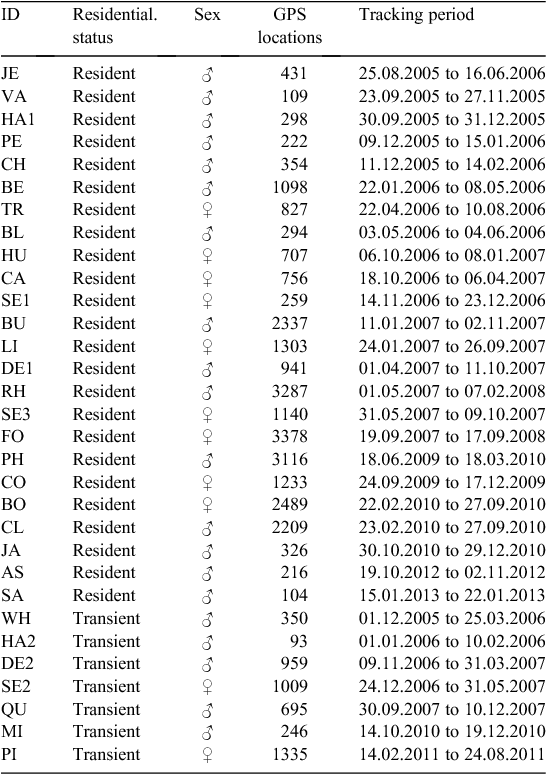
Habit Research (Victoria, BC) GPS/VHF collars were used on most coyotes. With good satellite availability, each of these collars recorded a GPS position at hourly intervals. Accuracy of GPS collars was ±15 m. Collars were mounted with Telonics BCP-2 (Mesa, AZ) or Sirtrack (Havelock North, New Zealand), programmable release mechanisms enabling detachment of the collars at a pre-specified time and date. Collars were programmed to release 12 months after capture (predicted battery longevity), but sometimes were dropped or stopped working earlier, resulting in different tracking periods. Two coyotes were fitted with wireless GPS collar prototypes (ATT TeleNav, Sunnyvale, CA, or Mr Lee Technologies, Anderson, SC). Wireless collars reported data at regular intervals of 15 min by SMS. Relocations were subsampled to 1 h intervals for the purpose of the analysis. Tracking period and number of GPS locations are shown in Table 1.
|
Categorising residents and transients
Following Gese et al. (1988), Kamler et al. (2005) and Gehrt et al. (2009), we distinguished resident and transient coyotes by examining movement patterns over the tracking period. Resident coyotes were defined as those consistently frequenting the same home range and core areas (areas within the 40% volume contours as determined by point density kernel analyses). Residents could be identified within two weeks of capture by restricted and repetitive movement patterns. Transient coyotes were distinguished from resident coyotes by wide-ranging, unpredictable movements that spanned multiple resident territories. Data from animals that changed status (i.e. from resident to transient or vice versa) were treated as if from different individuals before and after the change, because shift in residency leads to behavioural change (Bekoff 1977) and different third-order selection (Hinton et al. 2015). Three residents became transients during the study, one of which re-joined a different pack as a resident. All animals are described in Table 1.
Spatial data
We used the current Land Cover &Land Use GIS layer for Rhode Island from 2011 (RIGIS 2014) to categorise habitat within the study area. This digital layer meets a mapping standard of 1 : 5000 and has a minimum mapping unit of 0.2 ha. We aggregated eight land-cover classes (from the original 36), representing typical land cover of coastal Rhode Island, that characterized different levels of human usage. ‘Forest’ and ‘brushland–wetland’ are important for providing food, shelter and cover for travelling between habitat patches (e.g. Atwood et al. 2004). ‘Pasture’ and ‘cropland’ are two classes dominated by agriculture that have been shown to be used by residents and transients at different levels (Kamler et al. 2005). The three housing classes (i.e. low, medium and high density housing) show an increasing intensity of human usage. The last land-cover class with high human usage is ‘commercial–institutional’, which also includes industrial land. The eight land-cover classes are described in Table 2 and shown in Fig. 1C.

|
Analysis of resource selection
All spatial and statistical analyses were carried out in R 3.0.3 (R Development Core Team 2014). We followed the third-order resource selection approach outlined by Hebblewhite and Merrill (2008) and Gillies et al. (2006). First, we determined the land cover overlaid by each GPS location for each individual using function over of package sp (Pebesma and Bivand 2005). For an approximation of the home range, the 100% minimum convex polygon (MCP) was fitted to the GPS points (function mcp of package adehabitatHR; Calenge 2006) and clipped with the land area of the islands (function gIntersection of package rgeos; Bivand and Rundel 2014). Within the MCP, regularly spaced points of equal number to the GPS locations were generated using function spsample of package sp. The land cover overlaid with these points was also determined. While GPS locations represent usage, sample locations represent availability to each individual (Gillies et al. 2006). We chose the 100% MCP, following similar resource selection studies (Gillies et al. 2006; Marks and Bloomfield 2006; Latham et al. 2013). Other approximations of home range, such as 95% MCP or kernel estimator, would have excluded occasional sallies and areas that animals pass through but spend very little time in (Powell 2000). Especially for transients, this would have resulted in home ranges much smaller than the area they were observed in and interacted with. One hundred per cent MCP also has the advantage that diurnal shelter sites at the margins of the home ranges are not excluded (Marks and Bloomfield 2006).
We used generalised mixed-effects models (GLMMs) for estimating the resource selection function, which are increasingly recognised as a powerful tool for this purpose (Gillies et al. 2006; Hebblewhite and Merrill 2008; Fieberg et al. 2010). They extend commonly used generalised linear models (Manly 2002) by the ability to account for unbalanced design (i.e. heterogeneity in the number of GPS points between animals) variation in selection among individuals, and the influence of total availability on resource selection in the form of random effects (Gillies et al. 2006; Hebblewhite and Merrill 2008; Fieberg et al. 2010). Random effects can take different forms – random intercept, random coefficient or a combination of both (Gillies et al. 2006). In order to find out which random effect was appropriate for our data, we followed Gillies et al. (2006) and Hebblewhite and Merrill (2008) and fitted GLMMs with different random effects, which were then compared based on their log-likelihood (LL) and the Akaike information criterion (AIC) (Crawley 2007; Hebblewhite and Merrill 2008). In addition, a likelihood ratio test (Crawley 2007) was carried out between the models (using anova.glmmadmb package glmmADMB; Fournier et al. 2012). The first model included a random intercept for each individual coyote; the second model included a random intercept and coefficient for each individual. Both models used the eight land-cover classes and the residential status (either transient or resident) as fixed effects with an interaction between the two, based on the assumption that selection for land cover varies between residents and transients. Generalised mixed-effects models were fitted using glmmadmb of package glmmADMB (Fournier et al. 2012). Binomial error distribution and a logit link function were chosen, as is recommended for these kinds of data (Gillies et al. 2006; Crawley 2007; Hebblewhite and Merrill 2008).
Following Hebblewhite and Merrill (2008), the data were separated into diurnal and nocturnal locations. Data on sunrise, sunset, dusk and dawn from Newport Airport, RI (provided by Steve Edwards, www.SunriseSunset.com), were joined to the coyote GPS points, which we then split into diurnal and nocturnal locations. Night was defined as the period between nautical dusk (one hour after sunset) and nautical dawn (one hour before sunrise), when the sun is 12° below the horizon. Nocturnal data included movements from the period of highest activity for urban and suburban coyotes (Way et al. 2004; Gehrt 2007). Data analysis was carried out following the procedure outlined above.
Finally, the re-transformed model coefficients and predictions were used to compare usage by transients and residents. Coefficients have values between 0 and 1, with values below 0.5 indicating that a certain land cover is used less than available (i.e. selected against), and values above 0.5 that it is used more than available (i.e. selected for). Confidence intervals (CI) were estimated using a Markov chain Monte Carlo approach with 5000 iterations implemented in glmmadmb of package glmmADMB. We calculated 95% CI as a more conservative, and 84% CI as a less conservative measure of independence (Payton and Greenstone 2003).
Results
Altogether, 32 121 GPS locations were recorded in the eight land-cover classes, 27 434 from residents (n = 24) and 4687 from transients (n = 7). On average, 1143 GPS locations were recorded for each resident and 670 for each transient. Figure 1A and B show all resident and transient coyote GPS locations on the two islands.
Comparing the two diurnal models, model fit (LL) increased (LLdaymodel1 = –1330; LLdaymodel2 = –791), while the AIC decreased in model two (AICdaymodel1 = 2695; AICdaymodel2 = 1631). The likelihood ratio test indicated that the introduction of the random coefficient significantly reduced deviance (P < 0.001). Only the model with random intercept and slope was fitted to nocturnal data (LLnight = –863, AICnight = 1775). Likewise, only results for model two (random slope and intercept) will be presented and discussed here.
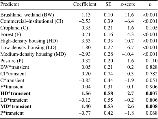
During the day (Fig. 2A), brushland–wetland was selected for most by residents and transients alike, followed by forest. Both land-cover classes were used more than they were available, while all other land-cover classes were used less than available. The model summaries for diurnal selection (Table 3) show significant (P < 0.05) interactions for medium- and high-density housing. Positive values indicate that selection was higher by transients than by residents.

|
|
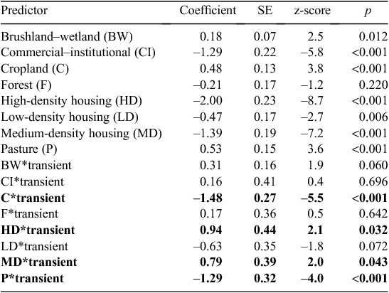
At night, patterns of land-cover selection changed and became more differentiated (Table 4; Fig. 2B). Residents showed strongest selection for cropland and pasture, followed by brushland–wetland, while forest was used slightly less or equal to the amount that it was available. Commercial–institutional and housing land cover was used less than available, but avoidance was higher during day than night. Low-density housing was less avoided than the other three classes. Transients showed a different pattern. During night, highest selection was found for brushland–wetland and selection for cropland and pasture was much lower compared with residents (significant interaction in the model and no overlap of 95% CI). Unlike residents, who showed decreasing selection with increasing housing density, selection for all housing classes by transients was similar, although the variation was quite large. Model interactions for high- and medium-density housing were significant for nocturnal selection and there was no overlap of the 84% CI for medium-density housing.
|
Discussion
Coyotes could be found in all parts of Aquidneck and Conanicut islands (Fig. 1A and B). Although they lived in close proximity to humans, avoidance of human development and human activity, expressed through negative selection, confirmed previous research on coyotes (Riley et al. 2003; Atwood et al. 2004; Gehrt et al. 2009; Gehrt et al. 2011; Hinton et al. 2015), but also on foxes (Gloor et al. 2001; Marks and Bloomfield 2006) and dingoes (Newsome et al. 2013). Especially during the day, coyotes used brushland–wetland and forest, all of which provide protective cover, disproportionate to the availability of these habitats. Land cover associated with a high risk of encountering humans during the day was used more at night, i.e. cropland, pasture, commercial–institutional and housing.
Our results indicate that transients and residents showed differences in third-order selection. Transients selected for cropland and pasture less than residents did. It is likely that these habitats are aggressively defended and, with the greater chance of detection on open lands, the chance of attack and injury may be too high for transients to risk using them. Likewise, Kamler and Gipson (2000) and Kamler et al. (2005) found that transient coyotes used grassland significantly less than residents and suggested that transients stuck to protective cover and probably less attractive habitat to avoid contact with residents. Hinton et al. (2015) also found that resident coyotes in rural North Carolina showed greater selection for agricultural land than transients, but, contrary to our results, transients did not avoid agricultural land.
Looking at the three housing classes and at commercial–institutional land further indicates differences in third-order selection. Avoidance by resident coyotes increased with increasing human activity from low-density to high-density housing. Avoidance of these four land-cover classes was higher during the day, when human activity is highest. Transient selection did not decline as clearly by day; confidence intervals range widely. In addition, results indicate that transients showed less avoidance of high- and medium-density housing overall than residents. Because resident coyotes expend energy defending their territories, the habitat choices of residents, not transients, likely reflect the actual preferences of coyotes. Transients are therefore relegated to second-string habitats with a greater risk of exposure to human activity. A similar pattern has been shown when comparing sick with healthy coyotes: sick coyotes were recorded five times more often in developed areas than healthy coyotes (Murray et al. 2015).
Strong selection for certain land cover by residents indicates its importance as foraging habitat (Atwood et al. 2004; Kamler et al. 2005). Although food availability was not part of this study, it is likely to be an additional driver behind the observed pattern. The land cover most attractive to resident coyotes during the night (i.e. the time of greatest activity) was cropland and pasture, and in coastal Rhode Island these open lands are home to many common prey species: meadow voles (Microtus pennsylvanicus), cottontails (Sylvilagus spp.), woodchucks (Marmota monax), deer (Odocoileus virginiana), Canada geese (Branta canadensis), as well as reptiles, amphibians, grassland-nesting birds and invertebrates. Coyotes can meet their resource needs in smaller home ranges if agricultural land is available (Hinton et al. 2015) and hunted more productively in open agricultural landscapes than in forests (Richer et al. 2002). This could explain why, in our study, brushland–wetland and forest, also rich in potential prey, were less attractive for resident coyotes during the night than cropland and pasture. Whether based on total presence or on availability of prey, in our study, transient coyotes were very likely being kept away from the most attractive foraging grounds by resident coyotes.
It is not clear whether food availability is also behind the avoidance of commercial–institutional and housing land cover. Coyotes, like other successful mid-sized predators, are generalists, with highly flexible diets, and can readily make use of the widely available anthropogenic food sources in cities (Contesse et al. 2004; Bateman and Fleming 2012; Murray et al. 2015). We assume that increasing food availability and decreasing risk (i.e. humans tolerating coyote presence) would make commercial–institutional and housing land cover more attractive to coyotes, but this was not part of this study. Newsome et al. (2015) found large individual differences in the utilisation of anthropogenic food, but no general difference between residents and transients.
Our study has several implications for coyote management and future research that might also be applicable to other mid-sized predators. First, we can confirm that coexistence strategies can build on the tendency of coyotes to avoid humans. Second, there is strong evidence that food resources are a driver of space use by coyotes. Reducing the quality of habitat in housing areas, for example, by limiting the amount of anthropogenic food through ‘no-feeding’ ordinances, will likely have an effect on reducing human–coyote conflicts. Such ordinances have recently been implemented in three municipalities in our Rhode Island study area (e.g. Middletown Town Code, Title IX, Ch. 90A: Feeding Non-domesticated Animals Ordinance) and GPS telemetry data from coyotes will help monitor their success. Third, behaviour specific to residential status must also be considered. Results indicate that transients show lower avoidance of areas of human activity than residents. It follows that transients, as long as food resources are limited in urban areas, are more likely to cause human–coyote conflicts, although we have no absolute numbers. We would expect that residents, by defending a territory and keeping out transients, decrease human–coyote conflicts. This remains to be tested. Fourth, preference, unbiased by intraspecific competition, could only be tested in a setting where no coyotes are present. The large islands on the east coast where coyotes have not or have only just arrived, in particular Long Island, can be considered natural experiments and colonisation should be closely monitored (Weckel et al. 2015). Based on our results and previous research, we would expect that on these islands human–coyote conflicts would only arise after a certain population density has been reached and coyotes are pushed closer to humans by competition with other coyotes. Fifth, future studies should address the importance of landscape configuration on human–coyote interactions. We have shown the importance of brushland–wetlands, forests, cropland and pasture for coyotes in coastal Rhode Island. It is likely that their depletion and fragmentation will increase human–coyote conflicts, because the animals will have to cross through more land dominated by human activity.
Management and research implications from our study area should apply to much of the eastern coastal US and perhaps beyond. However, our island study areas may differ from mainland sites is several ways. In a mainland study in Maine, 86% of coyote pups dispersed in the first year and water features deflected movements and resulted in concentrations of dispersers near water barriers (Harrison 1992). In our study, water gaps may have served as impediments to the dispersal of island coyotes. As a result, island coyote populations may have higher densities than mainland sites for both residents and transients. It was not possible to assess density in this study, but we hope to look at this in the future.
Acknowledgements
Thanks are due to: Peter Auger, Charles Brown, Otter Brown, Diane Chellis, Charles Fitzpatrick, David Francazio, Doreen Gabriel, Meagan Griffin, Melissa Harrington, Tracy Johnson, Katie Kalafut, Lyn Malone, Lynne Malonnee, Bob Mastin, Edith McBean, Glenn and Eli Mitchell, Kristin Pauly, Amy Pratt, Diana and Fred Prince, Susan Silvia, Christie Smith, Spencer Tripp, Richard Wolfe, and the editors and anonymous reviewers. We thank Roger Powell for comments contributing to the development of this manuscript. We would also like to thank the many local landowners and farmers who permitted us access to their lands, and Steve Edwards (sunrisesunset.com) for providing twilight times. We are also grateful to our funders: The Prince Charitable Trusts, The Rhode Island Foundation Fund for Animal Welfare, RI DEM (Legislative Grants), the van Beuren Foundation, The Bafflin Foundation, West Greenwich Animal Hospital, ESRI, The Potter League for Animals, Trimble, Jamestown Educational Foundation, AT&T, the Ali Packer Dunn Memorial Fund, Naval Station Newport, Custom House Coffee, and our private contributors. We are indebted to Spencer Tripp, wildlife trapper, and Charles Brown, furbearer biologist, at Rhode Island DEM, for advice and help in the field.
References
Allen, B. L., Goullet, M., Allen, L. R., Lisle, A., and Leung, L. K. P. (2013). Dingoes at the doorstep: preliminary data on the ecology of dingoes in urban areas. Landscape and Urban Planning 119, 131–135.| Dingoes at the doorstep: preliminary data on the ecology of dingoes in urban areas.Crossref | GoogleScholarGoogle Scholar |
Atwood, T. C., Weeks, H. P., and Gehring, T. M. (2004). Spatial ecology of coyotes along a suburban-to-rural gradient. The Journal of Wildlife Management 68, 1000–1009.
| Spatial ecology of coyotes along a suburban-to-rural gradient.Crossref | GoogleScholarGoogle Scholar |
Bateman, P. W., and Fleming, P. A. (2012). Big city life: carnivores in urban environments. Journal of Zoology 287, 1–23.
| Big city life: carnivores in urban environments.Crossref | GoogleScholarGoogle Scholar |
Bekoff, M. (1977). Canis latrans. Mammalian Species 79, 1–9.
| Canis latrans.Crossref | GoogleScholarGoogle Scholar |
Bivand, R. S., and Rundel, C. (2014). ‘rgeos: Interface to Geometry Engine – Open Source (GEOS). R Package Version 0.3–6.’ Available at: http://CRAN.R-project.org/package=rgeos [verified 20 January 2015].
Calenge, C. (2006). The package ‘adehabitat’ for the R software: a tool for the analysis of space and habitat use by animals. Ecological Modelling 197, 516–519.
| The package ‘adehabitat’ for the R software: a tool for the analysis of space and habitat use by animals.Crossref | GoogleScholarGoogle Scholar |
Contesse, P., Hegglin, D., Gloor, S., Bontadina, F., and Deplazes, P. (2004). The diet of urban foxes (Vulpes vulpes) and the availability of anthropogenic food in the city of Zurich, Switzerland. Mammalian Biology Zeitschrift fur Saugetierkunde 69, 81–95.
Crawley, M. J. (2007). ‘The R Book.’ (John Wiley & Sons: West Sussex, UK.)
Fieberg, J., Matthiopoulos, J., Hebblewhite, M., Boyce, M. S., and Frair, J. L. (2010). Correlation and studies of habitat selection: problem, red herring or opportunity? Philosophical Transactions of the Royal Society of London. Series B, Biological Sciences 365, 2233–2244.
| Correlation and studies of habitat selection: problem, red herring or opportunity?Crossref | GoogleScholarGoogle Scholar | 20566500PubMed |
Fournier, D. A., Skaug, H. J., Ancheta, J., Ianelli, J., Magnusson, A., Maunder, M. N., Nielsen, A., and Sibert, J. (2012). AD model builder: using automatic differentiation for statistical inference of highly parameterized complex nonlinear models. Optimization Methods & Software 27, 233–249.
| AD model builder: using automatic differentiation for statistical inference of highly parameterized complex nonlinear models.Crossref | GoogleScholarGoogle Scholar |
Gehrt, S. D. (2007). Ecology of coyotes in urban landscapes. In ‘Proceedings of the 12th Wildlife Damage Management Conference’. (Eds D. L. Nolte, W. M. Arjo and D. H. Stalman.) pp. 1–10.
Gehrt, S. D., Anchor, C., and White, L. A. (2009). Home range and landscape use of coyotes in a metropolitan landscape: conflict or coexistence? Journal of Mammalogy 90, 1045–1057.
| Home range and landscape use of coyotes in a metropolitan landscape: conflict or coexistence?Crossref | GoogleScholarGoogle Scholar |
Gehrt, S. D., Brown, J. L., and Anchor, C. (2011). Is the urban coyote a misanthropic synanthrope? The case from Chicago. Cities and the Environment 4, 3.
Gese, E. M., Rongstad, O. J., and Mytton, W. R. (1988). Home range and habitat use of coyotes in southeastern Colorado. The Journal of Wildlife Management 52, 640–646.
| Home range and habitat use of coyotes in southeastern Colorado.Crossref | GoogleScholarGoogle Scholar |
Gese, E. M., Morey, P. S., and Gehrt, S. D. (2012). Influence of the urban matrix on space use of coyotes in the Chicago metropolitan area. Journal of Ethology 30, 413–425.
| Influence of the urban matrix on space use of coyotes in the Chicago metropolitan area.Crossref | GoogleScholarGoogle Scholar |
Gibeau, M. L. (1998). Use of urban habitats by coyotes in the vicinity of Banff Alberta. Urban Ecosystems 2, 129–139.
| Use of urban habitats by coyotes in the vicinity of Banff Alberta.Crossref | GoogleScholarGoogle Scholar |
Gillies, C. S., Hebblewhite, M., Nielsen, S. E., Krawchuk, M. A., Aldridge, C. L., Frair, J. L., Saher, D. J., Stevens, C. E., and Jerde, C. L. (2006). Application of random effects to the study of resource selection by animals. Journal of Animal Ecology 75, 887–898.
| Application of random effects to the study of resource selection by animals.Crossref | GoogleScholarGoogle Scholar | 17009752PubMed |
Gloor, S., Bontadina, F., Hegglin, D., Deplazes, P., and Breitenmoser, U. (2001). The rise of urban fox populations in Switzerland. Mammalian Biology 66, 155–164.
Gompper, M. E. (2002). Top carnivores in the suburbs? Ecological and conservation issues raised by colonization of north-eastern North America by coyotes. Bioscience 52, 185–190.
| Top carnivores in the suburbs? Ecological and conservation issues raised by colonization of north-eastern North America by coyotes.Crossref | GoogleScholarGoogle Scholar |
Grinder, M. I., and Krausman, P. R. (2001). Home range, habitat use, and nocturnal activity of coyotes in an urban environment. The Journal of Wildlife Management 65, 887–898.
| Home range, habitat use, and nocturnal activity of coyotes in an urban environment.Crossref | GoogleScholarGoogle Scholar |
Harrison, D. J. (1992). Dispersal characteristics of juvenile coyotes in Maine. The Journal of Wildlife Management 56, 128–138.
| Dispersal characteristics of juvenile coyotes in Maine.Crossref | GoogleScholarGoogle Scholar |
Hebblewhite, M., and Merrill, E. (2008). Modelling wildlife–human relationships for social species with mixed-effects resource selection models. Journal of Applied Ecology 45, 834–844.
| Modelling wildlife–human relationships for social species with mixed-effects resource selection models.Crossref | GoogleScholarGoogle Scholar |
Hinton, J. W., van Manen, F. T., and Chamberlain, M. J. (2015). Space use and habitat selection by resident and transient coyotes (Canis latrans). PLoS One 10, e0132203.
| Space use and habitat selection by resident and transient coyotes (Canis latrans).Crossref | GoogleScholarGoogle Scholar | 26148130PubMed |
Johnson, D. H. (1980). The comparison of usage and availability measurements for evaluating resource preference. Ecology 61, 65–71.
| The comparison of usage and availability measurements for evaluating resource preference.Crossref | GoogleScholarGoogle Scholar |
Kamler, J. F., and Gipson, P. S. (2000). Space and habitat use by resident and transient coyotes. Canadian Journal of Zoology 78, 2106–2111.
| Space and habitat use by resident and transient coyotes.Crossref | GoogleScholarGoogle Scholar |
Kamler, J. F., Ballard, W. B., Lemons, P. R., and Gilliland, R. L. (2005). Home range and habitat use of coyotes in an area of native prairie, farmland and CRP fields. American Midland Naturalist 153, 396–404.
| Home range and habitat use of coyotes in an area of native prairie, farmland and CRP fields.Crossref | GoogleScholarGoogle Scholar |
Latham, A. D. M., Latham, M. C., Boyce, M. S., and Boutin, S. (2013). Spatial relationships of sympatric wolves (Canis lupus) and coyotes (C. latrans) with woodland caribou (Rangifer tarandus caribou) during the calving season in a human-modified boreal landscape. Wildlife Research 40, 250–260.
| Spatial relationships of sympatric wolves (Canis lupus) and coyotes (C. latrans) with woodland caribou (Rangifer tarandus caribou) during the calving season in a human-modified boreal landscape.Crossref | GoogleScholarGoogle Scholar |
Legget, P., and Legget, R. (1988). ‘Autobiography of Leggett’s Fox Trapping Methods.’ (Legget’s: Boonsboro, MD.)
Magle, S. B., Poessel, S. A., Crooks, K. R., and Breck, S. W. (2014a). More dogs less bite: the relationship between human–coyote conflict and prairie dog colonies in an urban landscape. Landscape and Urban Planning 127, 146–153.
| More dogs less bite: the relationship between human–coyote conflict and prairie dog colonies in an urban landscape.Crossref | GoogleScholarGoogle Scholar |
Magle, S. B., Simoni, L. S., Lehrer, E. W., and Brown, J. S. (2014b). Urban predator–prey association: coyote and deer distributions in the Chicago metropolitan area. Urban Ecosystems 17, 875–891.
| Urban predator–prey association: coyote and deer distributions in the Chicago metropolitan area.Crossref | GoogleScholarGoogle Scholar |
Manly, B. F. J. (2002). ‘Resource Selection by Animals.’ (Kluwer Academic Publishers: Dordrecht, Netherlands.)
Marks, C. A., and Bloomfield, T. E. (2006). Home-range size and selection of natal den and diurnal shelter sites by urban red foxes (Vulpes vulpes) in Melbourne. Wildlife Research 33, 339–347.
| Home-range size and selection of natal den and diurnal shelter sites by urban red foxes (Vulpes vulpes) in Melbourne.Crossref | GoogleScholarGoogle Scholar |
Murray, M., Edwards, M. A., Abercrombie, B., and Saint Clair, C. C. (2015). Poor health is associated with use of anthropogenic resources in an urban carnivore. Proceedings of the Royal Society of London. Series B, Biological Sciences 282, 20150009.
| Poor health is associated with use of anthropogenic resources in an urban carnivore.Crossref | GoogleScholarGoogle Scholar |
Newsome, T. M., Ballard, G., Dickman, C. R., Fleming, P. J. S., and van de Ven, R. (2013). Home range, activity and sociality of a top predator, the dingo: a test of the resource dispersion hypothesis. Ecography 36, 914–925.
| Home range, activity and sociality of a top predator, the dingo: a test of the resource dispersion hypothesis.Crossref | GoogleScholarGoogle Scholar |
Newsome, S. D., Garbe, H. M., Wilson, E. C., and Gehrt, S. D. (2015). Individual variation in anthropogenic resource use in an urban carnivore. Oecologia 178, 115–128.
| Individual variation in anthropogenic resource use in an urban carnivore.Crossref | GoogleScholarGoogle Scholar | 25669449PubMed |
Payton, M. E., and Greenstone, M. H. (2003). Overlapping confidence intervals or standard error intervals: what do they mean in terms of statistical significance? Journal of Insect Science 3, 34.
| 15841249PubMed |
Pebesma, E. J., and Bivand, R. S. (2005). Classes and methods for spatial data in R. R News 5, 9–13.
Poessel, S. A., Breck, S. W., Teel, T. L., Shwiff, S., Crooks, K. R., and Angeloni, L. (2013). Patterns of human–coyote conflicts in the Denver metropolitan area. The Journal of Wildlife Management 77, 297–305.
| Patterns of human–coyote conflicts in the Denver metropolitan area.Crossref | GoogleScholarGoogle Scholar |
Powell, R. A. (2000). Animal home ranges and territories and home range estimators. In ‘Research Techniques in Animal Ecology: Controversies and Consequences’. (Eds L. Boitani and T. K. Fuller.) pp. 65–110. (Columbia University Press, New York.)
R Development Core Team (2014). ‘R: a Language and Environment for Statistical Computing.’ 3rd edn. (R Foundation for Statistical Computing.) Available at: http://www.R-project.org/ [verified 29 July 2015]
Richer, M.-C., Crête, M., Ouellet, J. P., Rivest, L. P., and Huot, J. (2002). The low performance of forest versus rural coyotes in northeastern North America: inequality between presence and availability of prey. Ecoscience 9, 44–54.
RIGIS (2014). ‘Land Cover/Land Use for Rhode Island 2011. Rhode Island Geographic Information System (RIGIS) Data Distribution System.’ (Environmental Data Center, University of Rhode Island, Kingston, Rhode Island.) Available at: http://www.edc.uri.edu/rigis [verified 9 October 2014].
Riley, S. P. D., Sauvajot, R. M., Fuller, T. K., York, E. C., Kamradt, D. A., Bromley, C., and Wayne, R. K. (2003). Effects of urbanization and habitat fragmentation on bobcats and coyotes in southern California. Conservation Biology 17, 566–576.
| Effects of urbanization and habitat fragmentation on bobcats and coyotes in southern California.Crossref | GoogleScholarGoogle Scholar |
Sacks, B. N., Brown, S. K., and Ernest, H. B. (2004). Population structure of California coyotes corresponds to habitat-specific breaks and illuminates species history. Molecular Ecology 13, 1265–1275.
| 1:CAS:528:DC%2BD2cXktl2rtr8%3D&md5=b40164829a2ed2866edf7d8577a1ef2cCAS | 15078462PubMed |
Way, J. G. (2002). Radio-collared coyote crosses Cape Cod Canal. Northeast Wildlife 57, 63–65.
Way, J. G., Ortega, I. M., and Strauss, E. G. (2004). Movement and activity patterns of eastern coyotes in a coastal, suburban environment. Northeastern Naturalist 11, 237–254.
| Movement and activity patterns of eastern coyotes in a coastal, suburban environment.Crossref | GoogleScholarGoogle Scholar |
Weckel, M., Bogan, D. A., Burke, R. L., Nagy, C., Siemer, W. F., Green, T., and Mitchell, N. (2015). Coyotes go ‘Bridge and Tunnel’: a narrow opportunity to study the socio-ecological impacts of coyote range expansion on Long Island, NY pre- and post-arrival. Cities and the Environment 8, 5.
White, L. A., and Gehrt, S. D. (2009). Coyote attacks on humans in the United States and Canada. Human Dimensions of Wildlife 14, 419–432.
| Coyote attacks on humans in the United States and Canada.Crossref | GoogleScholarGoogle Scholar |
Windberg, L. A., and Knowlton, F. F. (1988). Management implications of coyote spacing patterns in southern Texas. The Journal of Wildlife Management 52, 632–640.
| Management implications of coyote spacing patterns in southern Texas.Crossref | GoogleScholarGoogle Scholar |