

Have droughts and increased water extraction from the Murray River (Australia) reduced coastal ocean productivity?
Hannah C. C. Auricht A B , Kenneth D. Clarke A , Megan M. Lewis A and Luke M. Mosley AA School of Biological Sciences, University of Adelaide, SA 5005, Australia.
B Corresponding author. Email: hannah.auricht@adelaide.edu.au
Marine and Freshwater Research 69(3) 343-356 https://doi.org/10.1071/MF17226
Submitted: 26 July 2017 Accepted: 9 October 2017 Published: 7 December 2017
CSIRO 2018 Open Access CC BY-NC-ND
Abstract
River discharges are decreasing in many regions of the world; however, the consequences of this on water quality and primary productivity of receiving coastal oceans are largely unclear. We analysed satellite remote-sensing data (MODIS) of the coastal ocean zone that receives outflows from the Murray River, from 2002 to 2016. This system has experienced historical flow reductions and a recent extreme hydrological ‘Millennium’ drought. Remotely sensed chlorophyll-a and particulate organic carbon in the coastal ocean were strongly correlated with river outflows (R2 > 0.6) in an 8-km radial buffer zone from the Murray Mouth, and the river influence extended up to ~60 km from the Murray Mouth during high-flow periods. This distance was approximately three times greater than the freshwater plume extent during maximum flows in 2011, suggesting that new primary productivity was created. In contrast, there was no additional coastal ocean productivity above background levels from 2007 to 2010 when river outflows ceased. Hindcast calculations based on historical flows from 1962 to 2002 suggest that declining Murray River flows have greatly reduced primary productivity in adjacent coastal waters. This has potential consequences for higher trophic levels and should be considered in future management planning.
Additional keywords: climate change, MODIS, primary productivity, river outflows.
Introduction
Many river systems around the world are stressed because of excessive water extraction for irrigation, industrial use and river regulation. These stressors can affect the natural variability and volume of freshwater outflows from rivers to oceans. Climate change is further altering discharge patterns of many rivers, in terms of both magnitude and variability (Milly et al. 2005), as well as causing increasingly frequent and severe droughts (Dai 2012). This will undoubtedly result in increased frequency and length of extreme low-flow periods in many rivers in the future.
Changes in river discharge volumes and patterns influence coastal water quality and ecosystems by modifying the supply of dissolved (e.g. nutrients) and suspended material. Many previous studies have focused on the potential negative effects or risks of river outflows to marine ecosystems as a result of transport of land-based pollutants from rivers to oceans (Alvarez-Romero et al. 2013; Costanzini et al. 2014; Petus et al. 2014a, 2014b; Yu et al. 2014; Devlin et al. 2015; Fernández-Nóvoa et al. 2015). However, currently there is limited understanding of how altered, reduced or complete lack of flow of freshwater affects estuarine and open coastal marine systems (Gillanders and Kingsford 2002). Acker et al. (2005) found that phytoplankton biomass in the nutrient-limited region near the mouth of Chesapeake Bay was significantly higher during an extremely high flow period than during an extremely low flow drought period. This was due to delivery of excess nutrients by the Susquehanna River into the bay, leading to increased phytoplankton biomass, turbidity and eutrophication. The study by Acker et al. (2005) was temporally limited and investigated effects on productivity caused by flow only for 2 years. Gong et al. (2006) suggested that a reduction in primary productivity observed in the East China Sea was the indirect consequence of construction of the Three Gorges Dam, which altered and reduced outflow and nutrient contributions from the Yangtze River and, therefore, nutrient ratios in the sea. Similarly, Black et al. (2016) found that the highest abundances of pink snapper (Chrysophrys auratus) larvae in Port Phillip Bay (Australia) occurred during years of low to intermediate flow and nutrient inputs from the Yarra River, whereas the lowest larval abundances occurred in years of very high, very low or no freshwater flows. Although studies such as these provide evidence of the effects of changes to outflow on coastal ocean productivity and water quality, these findings are neither directly comparable to the influences of prolonged drought nor the compounding effects of over allocation and extraction of river water over the longer term. The potential consequences of lack of flow on coastal ocean productivity is, therefore, poorly understood and requires more research.
Satellite remote sensing offers opportunities to monitor ocean and water quality across broader spatial and temporal scales than do traditional in situ sampling techniques. However, together with in situ sampling of water-quality parameters, satellite remotely sensed data have greatly enhanced our knowledge about composition, occurrence and extension of river outflows (indicated by river plumes) in coastal waters (Petus et al. 2014b). It is a useful tool that can quantify several biophysical variables to examine changes in ocean productivity (Alvarez-Romero et al. 2013). These variables include coloured dissolved organic matter (CDOM), sea-surface temperature (SST), particulate organic carbon (POC), particulate inorganic carbon (PIC) and chlorophyll-a (Chl-a). Each of these components reflects, scatters and backscatters solar energy that can be measured by remote-sensing instruments. Remotely sensed Chl-a concentration, for example, is widely used as a proxy for measuring phytoplankton biomass in the upper surface layers of the ocean (Acker et al. 2005; Rinaldi et al. 2014; Harvey et al. 2015). Monitoring these variables enables assessment of water quality over large areas and periods of time, as well as the response of variables to prolonged changes in environmental conditions such as drought.
The Murray River is Australia’s largest and most important river system, and its flow regime has changed considerably over the past century with construction of weirs, dams and levees (Maheshwari et al. 1995). Large-scale water extraction predominantly for irrigated agriculture has also occurred and greatly reduced total flow through to the end of the river system and coastal ocean. The basin-wide water extraction has made the end of the river system increasingly susceptible to hydrological drought. Consumptive water use has reduced the average annual outflows at the Murray Mouth by 61%. Water now ceases to flow from the Murray Mouth 40% of the time, compared with 1% of the time before water-resource development (CSIRO 2008). Outflows from the Murray River between 2001 and 2010 were extremely low in the period now known as the ‘Millennium drought’ (Geddes et al. 2016). From 2007 to 2009, the river flows were so low that the river ceased to discharge to the ocean (Mosley et al. 2012). Following the end of the Millennium drought, there was a large flooding event across the Murray–Darling Basin in 2011–2012 that resulted in a high discharge to the coastal ocean. The longer-term flow reductions and the Millennium drought have had severe ecological consequences on the Lower Lakes, Coorong (see Fig. 1) and floodplain wetland systems at the end of the river system (Kingsford et al. 2011; Pittock and Finlayson 2011). However, the implications of reduced river outflows and flooding on coastal ocean productivity have not been assessed for this important river system.
|
The aim of the present study was to apply MODIS ocean colour imagery for the purpose of investigating Murray River outflows, with particular interest in the contrasting effects of drought and high-flow periods and how they may influence the primary productivity and water quality of the adjacent coastal ocean. We hypothesised that the zero river-outflow (extreme drought) period from 2007 to 2010 would result in greatly reduced coastal ocean productivity, whereas the high flow post-drought period (2011–2012) would result in high productivity in the coastal ocean. We use remotely sensed MODIS satellite imagery (available since 2002), hydrological data and hindcast simulations based on historical river flow, to address these questions. The findings are likely to be applicable to other large river systems that are experiencing reduced outflows as a result of water extraction, river regulation and climatic effects.
Materials and methods
Study area
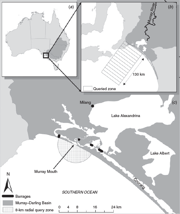
The study area (Fig. 1) comprised the coastal ocean zone outside of the Murray River Mouth, which is at the terminus of the Murray–Darling Basin and has a total catchment area of 1 061 469 km2 (equivalent to 14% of Australia’s total area). Prior to reaching the Murray Mouth, the river channel first discharges into two large (821.7-km2 total surface area) and shallow freshwater lakes (Lakes Alexandrina and Albert, known as the Lower Lakes). Water levels in the Lower Lakes and discharges to the Murray Mouth area are regulated by a series of barrages completed in the late 1940s to prevent seawater intrusion into the lakes as water resource development in the Murray–Darling Basin began to exacerbate this effect.
Hydrological and water-quality data
A daily outflow time series from the barrages to the Murray Mouth was obtained from the Department of Environment, Water and Natural Resources (South Australia) for the period 1962–2017. The outflows were estimated from water levels measured upstream and downstream of the barrages, coupled with rating curves for the structures, and number of barrage gates opened. Unfortunately, it is not possible to measure outflows directly at the Murray Mouth site because of its shifting and dynamic nature. The accepted method for outflow estimations (used by The Department of Environment, Water and Natural Resources and SA Water) is based on the sum of estimated flow over all barrages. The majority of flow from the barrages exits directly out the Murray Mouth, some of the flow (particularly from the southern-most Tauwitchere barrage) can mix into the Coorong temporarily.
Loads of nutrients exported with the water from the Murray Mouth were calculated. Long-term (2002–2017) water-quality data from Milang in Lake Alexandrina (Fig. 1) were provided by the South Australian Environment Protection Authority (SA EPA). Unfortunately, sufficient data of nutrients exported at the Murray Mouth and barrages do not exist. This means that Milang, a long-term site for measurement of lake water-quality parameters, is used to estimate nutrient loadings because (1) it has the longest water-quality record, (2) it has been found to best represent the mass balance of nutrients in the lake (Mosley et al. 2012) and (3) water in Lake Alexandrina has a short residence time and the water quality is generally similar to that in locations nearer the barrages, except during the 2007–2010 extreme low-flow, drought period where there was saline seepage back into the lake from the barrages (Stone et al. 2016). These data were collected on an approximately fortnightly to monthly basis and analysed for total nitrogen (TN) and phosphorus (TP) by using methods described previously (Mosley et al. 2012). For the purposes of calculating daily loads through the Murray Mouth, daily water-quality concentrations were interpolated using a cubic interpolation in MATLAB (MathWorks Australia, Sydney, NSW, Australia) and multiplied by the estimated daily discharge volume. These interpolations represented the measured data very well (see Fig. S1, available as Supplementary material to this paper).
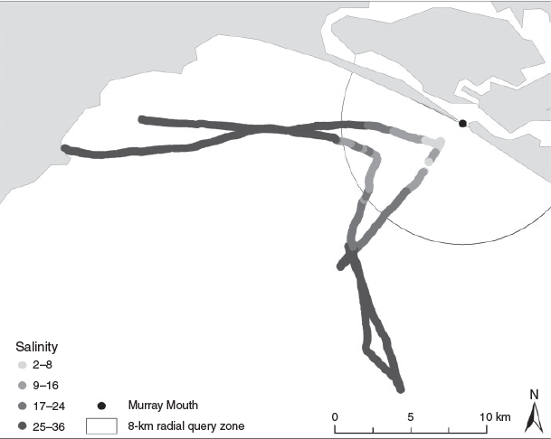
Additional coastal ocean water-quality data collected in situ along a transect on 25 February 2011 (high-flow period) were provided by the SA EPA. Continuously logged salinity data were collected by a calibrated water-quality sonde (YSI Pro Plus, Yellow Springs, OH, USA). Grab samples were also collected at 10 locations along the transect and analysed for turbidity by standard methods (Mosley et al. 2012).
MODIS–Aqua satellite-image products
Imagery from the moderate resolution imaging spectroradiometer (MODIS) was used in the present study, and has been used previously in several other coastal-water studies (Bierman et al. 2011; Petus et al. 2014a; Chaves et al. 2015; Devlin et al. 2015; Liu et al. 2015). The MODIS sensor is aboard the polar-orbiting satellite Aqua, launched in July 2002, and captures the entire earth surface every 1–2 days.
We used the following four standard MODIS–Aqua Level-3 mapped data products: Chl-a, POC, PIC and SST. These products are free to access on the NASA Ocean Colour website (https://oceancolor.gsfc.nasa.gov, accessed 6 November 2017) where details of their respective algorithms are also described (https://modis.gsfc.nasa.gov/data/dataprod/, accessed 6 November 2017). Briefly, the MODIS–Aqua Chl-a product uses the OC3M formula, the standard Chl-a algorithm distributed by NASA’s Goddard Space Flight Centre based on the SeaWiFS OC4v4 algorithm (O’Reilly et al. 2000). It is calculated using an empirical relationship derived from in situ measurements of Chl-a (a dataset consisting >2853 observations from a range of marine environments; O’Reilly et al. 2000) to the ratio of above-water reflectance at blue and green wavelengths (443–565 nm) and has been recommended for use in South Australian waters. Particulate organic carbon (POC) is calculated using an empirical relationship derived from in situ measurements of POC and blue-to-green band ratios of reflectances. Particulate organic carbon (POC) consists of autotrophic and heterotrophic microorganisms and biologically derived detrital particles suspended in seawater (Stramska 2009). The algorithm used to determine PIC from satellite imagery has been developed using observed in situ relationships among water leaving radiances, spectral backscattering coefficients and concentrations of calcium carbonate (Ackleson et al. 1988; Balch et al. 1989). This is the standard product algorithm included as part of the standard MODIS Level-2 ocean-colour product suite and the Level-3 PIC product suite. The MODIS SST product was used to retrieve the temperature of the ocean surface; specifically, the 11-µm daytime product was used, which follows field-based measurements well in South Australia’s coastal waters (Bierman 2010).
The OC3M algorithm is best suited for use in Case-1 waters (clear waters predominantly affected by phytoplankton) and is known to produce overestimates when used in Case-2 optically complex waters where visible amounts of suspended materials in the water column interfere. It has also been validated in South Australian waters by Bierman (2010). During high flows, suspended materials in the Murray River plume are visible close to the coast. However, these drop out quickly (i.e. within 10-km turbidity is <4 NTU; see Fig. S2, available as Supplementary material to this paper). Our zone of interest encompassed a larger area, up to 130 km from the Murray Mouth, and, consequently, use of the OC3M algorithm was considered most appropriate.
Imagery analysis
In total, 174 monthly composite images at 4-km spatial resolution of each product were downloaded, where each image is an average of all clear observations for each calendar month. Together, the 174 images are a complete temporal coverage of MODIS–Aqua at the time of the study (July 2002 to December 2016). Although these products can also be obtained at daily and weekly temporal resolution, cloud cover results in significant numbers of missing pixels. Hence, we used monthly composite images as this temporal resolution was sufficient for our purpose and minimising missing pixels was a priority.
All MODIS data were projected to the geographical coordinate system WGS_1984. So as to determine the temporal characteristics of Chl-a, POC, PIC and SST in the ocean adjacent to the Murray Mouth in relation to flow, the mean, maximum, minimum, range and standard deviation statistics were extracted from the data. First, an 8-km radius from the Murray Mouth was queried, which encapsulated the first six pixels nearest this point. In several instances, the closest two pixels to the Murray Mouth contained no data, a result of their exclusion because of either extended periods of cloud cover or because the values are outside the range of the algorithm, because of land ‘contamination’.
To create Hovmöller-type distance–time plots of each variable, a much larger area was assessed, which extended up to 130 km from the Murray Mouth, divided into 10-km incremental zones (see Fig. 1b). A rectangular area or ‘corridor’ ensured that approximately the same number of pixels at each incremental zone was queried, with the exception of the first three zones (accounting for the first 30 km of the incremental query area closest to the mouth), which included some of the land mask. The extent and direction of the query area incorporated the direction of the river plume (interpreted from viewing monthly composite imagery across years of high flow). It also deliberately excluded a known near-shore area of seasonal upwelling, to the south-east of the study area (Auricht 2015; Kämpf 2015; Kämpf and Kavi 2017) to further exclude contributions independent of outflow. Mean concentration statistics were then extracted for each distance-from-mouth zone, and every monthly composite image for all four of the variables. The means were then displayed in distance–time plots.
Extrapolation to historical flow dataset
Pearson’s correlation was calculated for the 8-km query area to assess the strength of relationships between barrage flow and remotely sensed ocean variables. This was done, first, on each variable’s complete dataset, including dates with no data or where flow was equal to zero, and, second, excluding dates with no data or where mean monthly flow was <10 000 ML. The aim of excluding values of flow below 10 000 ML per month was to reduce potential bias at low flows. However, because this did not result in any great change in strength of correlations (e.g. R2 of 0.61 for POC increased to R2 of 0.64 when data points below 10 000 ML were excluded), these data were not presented. The derived linear relationship from the correlation analysis for the 2002–2016 period was then used to predict historical Chl-a and POC concentrations for the full historical barrage outflow dataset (December 1962 to January 2017).
Results
River outflows and nutrient loads
The discharge from the Murray River system to the coastal ocean from 1960 to 2016 showed that higher, more frequent outflows occurred before the ‘Millennium’ drought (2001–2010, Fig. 2a). The discharge in the 2002–2017 MODIS study period is shown in Fig. 2b. Only minor discharges occurred from 2002 to 2006. There was zero discharge from river to the sea from 2007 to September 2010. A high-flow event occurred from 2011 to 2012, moderate flows from 2013 to 2015, and a recent high-flow event occurred in late 2016.
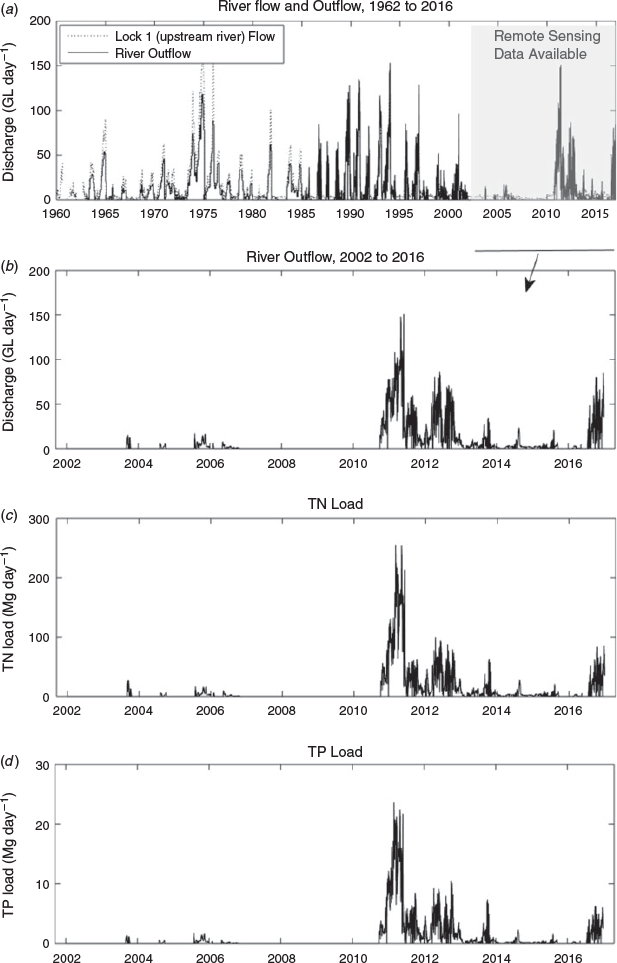
|
Total nutrient (TN and TP) loads to the coastal ocean showed very similar patterns to the river water outflows (Fig. 2c, d). This indicates that outflow is a good proxy for the total nutrient load to the coastal ocean.
Near-shore temporal patterns in water quality and primary productivity
A comparison of the MODIS POC and Chl-a data products for the whole study area in a high-flow period (May 2011) and no-flow, extreme-drought period (May 2008) is shown in Fig. 3. In the high-flow conditions (Fig. 3b, d), there was elevated Chl-a and POC in a plume extending ~50–60 km from the Murray Mouth, which was absent in the low-flow conditions (Fig. 3a, c).

|
Analysis of the full MODIS time series in the 8-km radial zone from the Murray Mouth showed that the monthly mean POC and Chl-a concentrations were highest at times of large river discharge, namely between September 2010 and January 2013, and late 2016 (Fig. 4a, b). During no-flow and very low-flow periods, there was a strong seasonal pattern for both POC and Chl-a that is independent of flow from the Murray Mouth. However, small deviations above the seasonal cycling patterns were apparent during minor river-outflow periods (i.e. higher Chl-a and POC concentrations occur during September and October 2003 and October and November 2005). In contrast, large increases in concentrations above the seasonal patterns were apparent during times in which mean barrage flow exceeded 10 000 ML per month.

|
The linear regression analysis results further supported a strong relationship between barrage flow and primary productivity in the 8-km radial zone beyond the Murray Mouth (Fig. 5). There was a strong correlation (R2 = 0.83) between Chl-a concentration in this zone and river outflow for the 2002 to late 2016 period (Fig. 5a). There was also a linear relationship between barrage flow and POC concentration but this correlation (R2 = 0.61) was weaker than that for Chl-a (Fig. 5b). Correlations between both Chl-a and POC with outflow decreased with an increasing distance from the Murray Mouth (refer to Figs S3 and S4, available as Supplementary material to this paper), but moderate correlations (R2 > 0.2 for POC and R2 > 0.4 for Chl-a) were present up to the 50–60-km zone.

|
Particulate inorganic carbon (PIC) showed a much more variable profile, with no clear relationship to outflow or season (Fig. 6a). In contrast, the temporal profile for SST in the 8-km zone showed no clear relationship with river outflow (Fig. 6b); however, a strong seasonal cycle was apparent, with high temperatures occurring between November and May and low temperatures between May and November.

|
The in situ water-quality monitoring conducted at the time of maximum outflows in the whole MODIS-data period (February 2011) showed that a discernible influence of the river outflow on ocean salinity occurred up to ~10–25 km from the Murray Mouth (Fig. 7).
|
Offshore temporal patterns in water quality and primary productivity
Hovmöller distance–time plots for the incremental query zone up to 130 km from the Murray Mouth showed strong increases in Chl-a (Fig. 8) and POC (Fig. 9) concentrations during the high-flow period of 2011, when compared with the extreme-drought period when there were no flows, in 2008. During the no-flow period, Chl-a concentrations were very low, between 0 and 2 mg m–3, within 30 km from the Murray Mouth and coast (Fig. 8b). However, during the high-flow period in May 2011, Chl-a concentrations up to 7 mg m–3 occurred as far as 20 km from the mouth and concentrations of 5–6 mg m–3 were observed up to 30 km from the mouth (Fig. 8c).

|

|
A very similar pattern to Chl-a was observed for POC for the no-flow 2008 and high-flow 2011 periods (Fig. 9). During the high-flow period, between February and July 2011, mean concentration of POC was ~600 mg m–3 at 30 km from the Murray Mouth, with discernible influences up to ~60 km (Fig. 9c). In contrast, mean concentration of POC was 300 mg m–3 in this zone during the extreme-drought (2008) period (Fig. 9b).
Hindcast mean Chl-a and POC concentrations
Figure 10 shows hindcast prediction of Chl-a (Fig. 10a) and POC (Fig. 10b) concentrations from 1962 to 2017, produced using the full historical outflow dataset and the regression equation derived from the correlation analysis (Fig. 5). These results suggest that before the Millennium drought, which began in the early 2000s, both Chl-a and POC concentrations were more frequently higher in the 8-km (and wider ~60-km) zone beyond the Murray Mouth (Fig. 10a, b), because there were more regular high-flow periods at this time (Fig. 2a). The hindcast also suggested that the more recent, post-Millenium-drought high-flow events (2011–2012, and late 2016) had an influence of similar magnitude to the high flows in the pre-2000 period.

|
Discussion
The results indicated that there are broad-scale temporal and spatial implications of reduced Murray River outflows on coastal ocean productivity. The MODIS–Aqua satellite-imagery time series enabled investigation of the effect of flow on coastal marine productivity beyond the Murray Mouth during the period from mid-2002 to late 2016, encompassing not only periods of prolonged drought (from early 2000 to August 2010) and including extreme drought (2007–2010), but also periods of high flow (2011–2012 and recently in late 2016). The results support our hypothesis that the coastal ocean environment beyond the Murray Mouth would have a much lower productivity (indicated by the Chl-a concentration) during the prolonged period of drought with no contributions of freshwater flows, than during the high-flow, post-drought period.
A notable increase in Chl-a and POC concentrations was observed within 8 km of the Murray Mouth at times of high flow, compared with low Chl-a and POC concentrations during times of no flow. Correlation analysis revealed strong relationships between mean barrage flow and Chl-a concentration (R2 = 0.83) and POC concentration (R2 = 0.61) in this area (Fig. 5). It is likely that a larger proportion of the Chl-a and POC sensed in this region during high flows could result directly from the export of freshwater from the eutrophic Lower Lakes upstream of the barrages, rather than from new coastal ocean phytoplankton activity. The in situ monitoring data available during maximum outflows (February 2011) supported this because they showed that the outflow diluted salinity from ambient marine values within ~10–15 km of the Murray Mouth.
It is possible that because of the shallow depth in the 8-km Murray Mouth zone (<20 m, Geoscience Australia 2009), when flows are very low or cease, MODIS measurements may produce over-estimates of Chl-a because of bottom reflectance (Bierman 2010). This would be less likely during times of high flow when the zone is turbid, because sources of error in these circumstances are more likely as a result of the presence of other constituents in the water column than bottom reflectance. Beyond ~10 km from the Murray Mouth, the depth of the water is greater than 20 m. Thus, ocean-colour estimates should not be affected by bottom reflectance beyond this distance. Analysis of the MODIS data also showed that the influence of Murray River outflows on the coastal ocean is considerably far reaching, particularly during high flows. During the high-flow periods (from 2011 to 2012 and, more recently, late 2016), elevated bloom concentrations of both Chl-a and POC extended up to ~60 km beyond the Murray Mouth (Figs 8, 9). It may also be possible that apparent Chl-a and POC estimations are compromised by CDOM from the river outflows (which can interfere with estimates of blue to green reflectance ratios; Garcia et al. 2006; Kämpf 2015; Shanmugam 2011), in which case, they may actually be an estimation of combined CDOM and phytoplankton biomass. However, the observed zone of Murray River influence was at least three times greater than was the measured maximum extent of salinity dilution caused by the freshwater river plume (indicated by salinity; see Fig. 7), and turbidity was substantially lower beyond 10 km from the mouth. This indicated that new coastal ocean productivity had been stimulated by the outflows. Further study and in situ sampling would be useful to validate this and the MODIS data under high-flow conditions. Nevertheless, these findings are also consistent with previous findings of extensive spatial influence of river plumes on the productivity of the coastal ocean in other locations (e.g. Smith and DeMaster 1996).
The input of riverine dissolved nutrients can remove nutrient limitations that commonly provide a barrier to phytoplankton growth in the ocean (Acker et al. 2005), although removal of light limitations associated with high turbidity in near-shore areas may be required first (Smith and DeMaster 1996). Considering that much of the nutrient load exiting the Murray River system is in organic forms (Mosley et al. 2012), it appears likely that release of dissolved nutrients from breakdown of this organic material (e.g. by microbial breakdown and plasmolysis of freshwater phytoplankton cells as a result of osmotic shock; Hart et al. 1991) occurs and stimulates new ocean productivity. In contrast to POC, PIC showed no clear relationship with flow, which suggests that the PIC in the Murray River coastal zone is an insensitive indicator of the outflow of river water (usually unsaturated with CaCO3; Mosley et al. 2013). This could be due to CaCO3 mineral buffering mechanisms and suggests that PIC is a less useful variable for tracing riverine influences on the coastal ocean. Similarly, SST showed no discernible change as a result of the river flows, possibly because the river water temperature was either similar, or equilibrated quickly, to the coastal ocean water.
During the extreme-drought period where no outflow occurred, remotely sensed Chl-a and POC concentrations in the coastal ocean were much lower and there was no plume detectable in the MODIS data. Lower flows are now much more frequent on the Murray River system because of large-scale water extraction for agriculture and river regulation (CSIRO 2008). Hindcast extrapolations of the remotely sensed data (based on correlation with flow from 2002 to late 2016) suggested that coastal ocean productivity is likely to have been much greater in the past, before large-scale water extraction and river regulation (Fig. 10). In particular, it appears that the frequency of high-productivity conditions in the ocean beyond the mouth would likely have been much higher when flows were more frequent and voluminous than they have been in the past decade. In contrast, for long periods in the past 15 years, Chl-a and POC have been within background seasonal concentrations.
Because phytoplankton biomass is the base of the marine food web, population dynamics and abundance of higher trophic levels and fishery resources are likely to be affected by reduced flows and extended drought periods. Although a limited number of studies reflect on potential implications of a complete lack of river outflows on marine environments, it is generally understood that changing the scale, frequency and seasonality of river outflows can have severe impacts on species that require food pulses for successful reproduction or larval survival (Drinkwater and Frank 1994; Whitfield and Marais 1999). Several studies have identified important relationships between outflow-stimulated productivity and populations of marine species and habitats as a result of these controls (Burrage et al. 2002; De Robertis et al. 2005; Burla et al. 2010; Brookes et al. 2015; Black et al. 2016). There is also a critical period at the point of first feeding by larvae where the presence of suitable amounts and types of food determine year-class strength (Hjort 1914).
In the coastal Murray River region that we studied, there was evidence that reduced outflows during the Millennium-drought period negatively influenced the pipi (Donax deltoides) fishery in the region, where variability in freshwater flows explained 45% of the variability in the relative abundance of the bivalve mollusc (Ferguson et al. 2013). The declining abundance of mulloway fish (Argyrosomus japonicus) may also be partly explained by environmental limitations resulting from the lack of flow; these species show preference for turbid estuaries and are dependent on freshwater outflows to create environments suitable for recruitment (Ferguson et al. 2013). The relative rarity and diminishment of suitable freshwater flow into the remnant estuary and coastal ocean has thus placed high strain and pressure on the few strong year classes that have resulted from years of above-average flow to continue the population (Ferguson et al. 2008). Considering this and the high age and size at maturity of A. japonicas (Griffiths 1996; Farmer 2008), extended periods of drought and reduced flow in the future could lead to a repeated failure of recruitment and, in an extreme scenario, cause local extinction of the species. These fisheries data strongly support wider implications of reduced Murray outflows and primary productivity on the adjacent coastal ocean. However, because the observed long-term decline in these species during the Millenium drought also occurred synchronously with severe overfishing (Ferguson et al. 2013), these additional effects on population dynamics also require consideration in management.
Past decision-making on water allocation and management on the Murray River, including large water volumes allocated for extraction by irrigators, has previously failed to consider impacts on coastal environments outside the river system. The focus has been on maintaining sufficient flows to maintain regulated water levels, water allocations for irrigators, and sufficient quality to meet irrigation and drinking-water requirements. Dredging has been undertaken for considerable periods over the past 15 years to keep the Murray Mouth open in the absence of sufficient flows. The Murray–Darling Basin Plan (MDBA 2010) that is currently being implemented is recovering water from irrigators, by buy-backs and efficiency improvements, to return it to the environment. ‘Maintaining an open Murray Mouth’ is an objective of the plan; however, beyond this, there is no consideration of the volume of outflows required to maintain coastal marine ecosystems. Of increasing concern are predictions that climate change will result in further outflow reductions (CSIRO 2008). Reducing discharge trends are occurring in many other global river systems as a result of climate change (10–40% reductions by 2050; Milly et al. 2005). Hence, significant reductions in coastal ocean productivity are likely to occur adjacent to many other river systems in the future, with flow-on effects on dependent species (e.g. invertebrates, fish, water birds) and industries (e.g. fisheries, tourism). The effects of outflows on the health and resilience of coastal ocean ecosystems require improved consideration in river management plans.
Conclusions
The present study investigated, for the first time, how outflow reductions and drought on the Murray River affect primary productivity in the adjacent coastal ocean. MODIS–Aqua ocean-colour products were analysed and Chl-a and POC concentrations in the coastal ocean showed a strong positive correlation with river outflow, up to 60 km from the Murray River Mouth. The increases in Chl-a and POC during high flows were far greater than was the freshwater-plume extent, indicating that the outflows stimulated new ocean productivity. Hindcast simulations indicated that flow reductions on the Murray River have greatly reduced the productivity of the coastal ocean over the past few decades because of the large-scale water extraction and a severe drought. This effect on the Murray River and coastal ocean and other large global river systems is likely to become more common as a result of climate change and other anthropogenic pressures. Higher trophic level (e.g. fish, shellfish, birds) productivity, recruitment and migration could also be greatly affected by declining primary productivity and could have severe implications for fisheries and, possibly, lead to the extinction of particular species. It would, therefore, be worthwhile in future research to also include investigation on these wider ecological impacts.
Conflicts of interest
The authors declare that they have no conflicts of interest.
Acknowledgements
We thank the NASA Goddard Space Flight Center, Ocean Ecology Laboratory, Ocean Biology Processing Group, for supply of the MODIS data. We kindly acknowledge the South Australian Environment Protection Authority (David Palmer) for providing water-quality data, the Department for Environment, Water and Natural Resources (Jarrod Eaton) for providing barrage-outflow data and Greg Ferguson (Primary Industries and Regions South Australia) for supplying fisheries information.
References
Acker, J. G., Lawrence, W. H., Leptoukh, G., Zhu, T., and Shen, S. (2005). Remotely sensed Chl-a at the Chesapeake Bay mouth is correlated with annual freshwater flow to Chesapeake Bay. Geophysical Research Letters 32, L05601.| Remotely sensed Chl-a at the Chesapeake Bay mouth is correlated with annual freshwater flow to Chesapeake Bay.Crossref | GoogleScholarGoogle Scholar |
Ackleson, S. G., Balch, W. M., and Holligan, P. M. (1988). White waters of the Gulf of Maine. Oceanography 1, 18–22.
| White waters of the Gulf of Maine.Crossref | GoogleScholarGoogle Scholar |
Alvarez-Romero, J. G., Devlin, M., da Silva, E. T., Petus, C., Ban, N. C., Pressey, R. L., Kool, J., Roberts, J. J., Cerdeira-Estrada, S., Wenger, A. S., and Brodie, J. (2013). A novel approach to model exposure of coastal-marine ecosystems to riverine flood plumes based on remote sensing techniques. Journal of Environmental Management 119, 194–207.
| A novel approach to model exposure of coastal-marine ecosystems to riverine flood plumes based on remote sensing techniques.Crossref | GoogleScholarGoogle Scholar | 1:CAS:528:DC%2BC3sXltVegtb4%3D&md5=ef8eb97c25bdee7091986d9bd5abbd72CAS |
Auricht, H. (2015). Monitoring sea surface temperature and phytoplankton in the Spencer Gulf using MODIS satellite imagery. B.Sc.(Hons) Thesis, University of Adelaide, Adelaide, SA, Australia.
Balch, W. M., Eppley, R. W., Abbott, M. R., and Reid, F. M. H. (1989). Bias in satellite-derived pigment measurements due to coccolithophores and dinoflagellates. Journal of Plankton Research 11, 575–581.
| Bias in satellite-derived pigment measurements due to coccolithophores and dinoflagellates.Crossref | GoogleScholarGoogle Scholar |
Bierman, P. E. (2010). Remote sensing to monitor interactions between aquaculture and the environment of Spencer Gulf, South Australia. Ph.D. Thesis, The University of Adelaide, Adelaide, SA, Australia.
Bierman, P., Lewis, M., Ostendorf, B., and Tanner, J. (2011). A review of methods for analysing spatial and temporal patterns in coastal water quality. Ecological Indicators 11, 103–114.
| A review of methods for analysing spatial and temporal patterns in coastal water quality.Crossref | GoogleScholarGoogle Scholar | 1:CAS:528:DC%2BC3cXhtlyntbnE&md5=80b032c69085c8419911b759d3a46658CAS |
Black, K. P., Longmore, A. R., Hamer, P. A., Lee, R., Swearer, S. E., and Jenkins, G. P. (2016). Linking nutrient inputs, phytoplankton composition, zooplankton dynamics and the recruitment of pink snapper, Chrysophrys auratus, in a temperate bay. Estuarine, Coastal and Shelf Science 183, 150–162.
| Linking nutrient inputs, phytoplankton composition, zooplankton dynamics and the recruitment of pink snapper, Chrysophrys auratus, in a temperate bay.Crossref | GoogleScholarGoogle Scholar | 1:CAS:528:DC%2BC28XhvVahtr7P&md5=0d13204a9d48f6c70b4ee43707660948CAS |
Brookes, J. D., Aldridge, K. T., Bice, C. M., Deegan, B., Ferguson, G. J., Paton, D. C., Sheaves, M., Ye, Q., and Zampatti, B. P. (2015). Fish productivity in the lower lakes and Coorong, Australia, during severe drought. Transactions of the Royal Society of South Australia 139, 189–215.
| Fish productivity in the lower lakes and Coorong, Australia, during severe drought.Crossref | GoogleScholarGoogle Scholar |
Burla, M., Baptista, A. M., Casillas, E., Williams, J. G., and Marsh, D. M. (2010). The influence of the Columbia River plume on the survival of steelhead (Oncorhynchus mykiss) and Chinook salmon (Oncorhynchus tshawytscha): a numerical exploration. Canadian Journal of Fisheries and Aquatic Sciences 67, 1671–1684.
| The influence of the Columbia River plume on the survival of steelhead (Oncorhynchus mykiss) and Chinook salmon (Oncorhynchus tshawytscha): a numerical exploration.Crossref | GoogleScholarGoogle Scholar |
Burrage, D. M., Heron, M. L., Hacker, J. M., Stieglitz, T. C., Steinberg, C. R., and Prytz, A. (2002). Evolution and dynamics of tropical river plumes in the Great Barrier Reef: an integrated remote sensing and in situ study. Journal of Geophysical Research. Oceans 107, 1–22.
Chaves, J. E., Werdell, P. J., Proctor, C. W., Neeley, A. R., Freeman, S. A., Thomas, C. S., and Hooker, S. B. (2015). Assessment of ocean color data records from MODIS–Aqua in the western Arctic Ocean. Deep-sea Research – II. Topical Studies in Oceanography 118, 32–43.
| Assessment of ocean color data records from MODIS–Aqua in the western Arctic Ocean.Crossref | GoogleScholarGoogle Scholar | 1:CAS:528:DC%2BC2MXksl2ktLs%3D&md5=fbe443d05e733846e895a2246924e253CAS |
Costanzini, S., Teggi, S., and Ghermandi, G. (2014). Remote sensing and GIS for the modeling of persistent organic pollutant in the marine environment. Proceedings of the Society for Photo-Instrumentation Engineers 9240, 924012.
| Remote sensing and GIS for the modeling of persistent organic pollutant in the marine environment.Crossref | GoogleScholarGoogle Scholar |
CSIRO (2008). Water availability in the Murray–Darling Basin. Summary of a report from CSIRO to the Australian Government. CSIRO, Canberra, ACT, Australia.
Dai, A. G. (2012). Increasing drought under global warming in observations and models. Nature Climate Change 3, 52–58.
| Increasing drought under global warming in observations and models.Crossref | GoogleScholarGoogle Scholar |
De Robertis, A., Morgan, C. A., Schabetsberger, R. A., Zabel, R. W., Brodeur, R. D., Emmett, R. L., Knight, C. M., Krutzikowsky, G. K., and Casillas, E. (2005). Columbia River plume fronts. II. Distribution, abundance and feeding ecology of juvenile salmon. Marine Ecology Progress Series 299, 33–44.
| Columbia River plume fronts. II. Distribution, abundance and feeding ecology of juvenile salmon.Crossref | GoogleScholarGoogle Scholar |
Devlin, M. J., Petus, C., da Silva, E., Tracey, D., Wolff, N. H., Waterhouse, J., and Brodie, J. (2015). Water quality and river plume monitoring in the Great Barrier Reef: an overview of methods based on ocean colour satellite data. Remote Sensing 7, 12909–12941.
| Water quality and river plume monitoring in the Great Barrier Reef: an overview of methods based on ocean colour satellite data.Crossref | GoogleScholarGoogle Scholar |
Drinkwater, K. F., and Frank, K. T. (1994). Effects of river regulation and diversion on marine fish and invertebrates. Aquatic Conservation 4, 135–151.
| Effects of river regulation and diversion on marine fish and invertebrates.Crossref | GoogleScholarGoogle Scholar |
Farmer, B. M. (2008). Comparisons of the biological and genetic characteristics of the Mulloway Argyrosomus japonicus (Sciaenidae) in different regions of Western Australia. Ph.D. Thesis, Murdoch University, WA, Australia.
Ferguson, G. J., Ward, T. M., and Geddes, M. C. (2008). Do recent age structures and historical catches of mulloway, Argyrosomus japonicus (Temminck & Schlegel, 1843), reflect freshwater inflows in the remnant estuary of the Murray River, South Australia? Aquatic Living Resources 21, 145–152.
| Do recent age structures and historical catches of mulloway, Argyrosomus japonicus (Temminck & Schlegel, 1843), reflect freshwater inflows in the remnant estuary of the Murray River, South Australia?Crossref | GoogleScholarGoogle Scholar |
Ferguson, G. J., Ward, T. M., Ye, Q. F., Geddes, M. C., and Gillanders, B. M. (2013). Impacts of drought, flow regime, and fishing on the fish assemblage in Southern Australia’s largest temperate estuary. Estuaries and Coasts 36, 737–753.
| Impacts of drought, flow regime, and fishing on the fish assemblage in Southern Australia’s largest temperate estuary.Crossref | GoogleScholarGoogle Scholar | 1:CAS:528:DC%2BC3sXptVCgt7s%3D&md5=99103f7a8c09ef043d376427467f6794CAS |
Fernández-Nóvoa, D., Mendes, R., deCastro, M., Dias, J. M., Sánchez-Arcilla, A., and Gómez-Gesteira, M. (2015). Analysis of the influence of river discharge and wind on the Ebro turbid plume using MODIS–Aqua and MODIS–Terra data. Journal of Marine Systems 142, 40–46.
| Analysis of the influence of river discharge and wind on the Ebro turbid plume using MODIS–Aqua and MODIS–Terra data.Crossref | GoogleScholarGoogle Scholar |
Garcia, V. M. T., Signorini, S., Garcia, C. A. E., and McClain, C. (2006). Empirical and semianalytical chlorophyll a algorithms in the southwestern Atlantic coastal region (25–40°S and 60–45°W). International Journal of Remote Sensing 27, 1539–1562.
| Empirical and semianalytical chlorophyll a algorithms in the southwestern Atlantic coastal region (25–40°S and 60–45°W).Crossref | GoogleScholarGoogle Scholar |
Geddes, M. C., Shiel, R. J., and Francis, J. (2016). Zooplankton in the Murray estuary and Coorong during flow and no-flow periods. Transactions of the Royal Society of South Australia 140, 74–89.
| Zooplankton in the Murray estuary and Coorong during flow and no-flow periods.Crossref | GoogleScholarGoogle Scholar |
Geoscience Australia (2009). Australian bathymetry and topography grid, June 2009. Geoscience Australia, Canberra, ACT, Australia. Available at https://ecat.ga.gov.au/geonetwork/srv/eng/search#!a05f7892-fae9-7506-e044-00144fdd4fa6 [Verified 18 September 2017].
Gillanders, B. M., and Kingsford, M. J. (2002). Impact of changes in flow of freshwater on estuarine and open coastal habitats and the associated organisms. Oceanography and Marine Biology 40, 233–309.
Gong, G.-C., Chang, J., Chiang, K.-P., Hsiung, T.-M., Hung, C.-C., Duan, S.-W., and Codispoti, L. A. (2006). Reduction of primary production and changing of nutrient ratio in the East China Sea: effect of the Three Gorges Dam? Geophysical Research Letters 33, L07610.
| Reduction of primary production and changing of nutrient ratio in the East China Sea: effect of the Three Gorges Dam?Crossref | GoogleScholarGoogle Scholar |
Griffiths, M. H. (1996). Life history of the Dusky kob Argyrosomus japonicus (Sciaenidae) off the east coast of South Africa. South African Journal of Marine Science 17, 135–154.
| Life history of the Dusky kob Argyrosomus japonicus (Sciaenidae) off the east coast of South Africa.Crossref | GoogleScholarGoogle Scholar |
Hart, B. T., Bailey, P., Edwards, R., Hortle, K., James, K., McMahon, A., Meredith, C., and Swadling, K. (1991). A review of the salt sensitivity of the Australian freshwater biota. Hydrobiologia 210, 105–144.
| A review of the salt sensitivity of the Australian freshwater biota.Crossref | GoogleScholarGoogle Scholar |
Harvey, E. T., Kratzer, S., and Philipson, P. (2015). Satellite-based water quality monitoring for improved spatial and temporal retrieval of chlorophyll-a in coastal waters. Remote Sensing of Environment 158, 417–430.
| Satellite-based water quality monitoring for improved spatial and temporal retrieval of chlorophyll-a in coastal waters.Crossref | GoogleScholarGoogle Scholar |
Hjort, J. (1914). ‘Fluctuations in the Great Fisheries of Northern Europe, Viewed in the Light of Biological Research.’ (Andr. Fred. Høst & Fils: Copenhagen, Denmark.)
Kämpf, J. (2015). Phytoplankton blooms on the western shelf of Tasmania: evidence of a highly productive ecosystem. Ocean Science 11, 1–11.
| Phytoplankton blooms on the western shelf of Tasmania: evidence of a highly productive ecosystem.Crossref | GoogleScholarGoogle Scholar |
Kämpf, J., and Kavi, A. (2017). On the ‘hidden’ phytoplankton blooms on Australia’s southern shelves. Geophysical Research Letters 44, 1466–1473.
| On the ‘hidden’ phytoplankton blooms on Australia’s southern shelves.Crossref | GoogleScholarGoogle Scholar |
Kingsford, R. T., Walker, K. F., Lester, R. E., Young, W. J., Fairweather, P. G., Sammut, J., and Geddes, M. C. (2011). A Ramsar wetland in crisis – the Coorong Lower Lakes and Murray Mouth, Australia. Marine and Freshwater Research 62, 255–265.
| A Ramsar wetland in crisis – the Coorong Lower Lakes and Murray Mouth, Australia.Crossref | GoogleScholarGoogle Scholar | 1:CAS:528:DC%2BC3MXjsVKksbg%3D&md5=813db4615c79b5f38d584180d9a8a8b4CAS |
Liu, D., Pan, D. L., Bai, Y., He, X. Q., Wang, D. F., Wei, J. A., and Zhang, L. (2015). Remote sensing observation of particulate organic carbon in the Pearl River Estuary. Remote Sensing 7, 8683–8704.
| Remote sensing observation of particulate organic carbon in the Pearl River Estuary.Crossref | GoogleScholarGoogle Scholar |
Maheshwari, B. L., Walker, K. F., and McMahon, T. A. (1995). Effects of regulation on the flow regime of the River Murray, Australia. Regulated Rivers: Research and Management 10, 15–38.
| Effects of regulation on the flow regime of the River Murray, Australia.Crossref | GoogleScholarGoogle Scholar |
MDBA (2010). ‘Guide to the Proposed Basin Plan: Technical Background.’ (Murray–Darling Basin Authority: Canberra, ACT, Australia.)
Milly, P. C. D., Dunne, K. A., and Vecchia, A. V. (2005). Global pattern of trends in streamflow and water availability in a changing climate. Nature 438, 347–350.
| Global pattern of trends in streamflow and water availability in a changing climate.Crossref | GoogleScholarGoogle Scholar | 1:CAS:528:DC%2BD2MXht1WksbfJ&md5=ad1c6c2f5bd94275e28b45d993aea4a1CAS |
Mosley, L. M., Zammit, B., Leyden, E., Heneker, T. M., Hipsey, M. R., Skinner, D., and Aldridge, K. T. (2012). The impact of extreme low flows on the water quality of the lower Murray River and lakes (South Australia). Water Resources Management 26, 3923–3946.
| The impact of extreme low flows on the water quality of the lower Murray River and lakes (South Australia).Crossref | GoogleScholarGoogle Scholar |
Mosley, L. M., Barnett, L., Leyden, E., Fradley, K., Iacopetta, J., Jolley, A.-M., Mettam, P., Natt, A., Palmer, D., Scott, P., Spencer, J., Stone, D., and Zammit, B. (2013). Water quality in the Lower Lakes during a hydrological drought: water quality monitoring report. (Environment Protection Authority: Adelaide, SA, Australia.) Available at www.epa.sa.gov.au/files/477561_lower_lakes_wq.pfd [Verified 6 November 2017].
O’Reilly, J. E. S., Maritorena, S., Seigel, D., O’Brien, M., Toole, D., Mitchell, B. G., Kahru, M., Chavez, F. P., Strutton, P., Cota, G. F., Hooker, S. B., McClain, C. R., Carder, K. L., Muller-Karger, F. E., Harding, L., Magnuson, A., Phinney, D., Moore, G. F., Aiken, J., Arrigo, K. R., Letelier, R. M., and Culver, M. E. (2000). Ocean Color Chlorophyll-a Algorithms for SeaWiFS, OC2 and OC4: Version 4. In ‘SeaWiFS Postlaunch Calibration and Validation Analyses, Part 3’. (Eds S. B. Hooker and E. R. Firestone.) NASA Technical Memorandum – SeaWiFS Postlaunch Technical Report Series, Vol. 11, pp. 1–49. Goddard Space Flight Center, Greenbelt, MD, USA.
Petus, C., da Silva, E. T., Devlin, M., Wenger, A. S., and Álvarez-Romero, J. G. (2014a). Using MODIS data for mapping of water types within river plumes in the Great Barrier Reef, Australia: towards the production of river plume risk maps for reef and seagrass ecosystems. Journal of Environmental Management 137, 163–177.
| Using MODIS data for mapping of water types within river plumes in the Great Barrier Reef, Australia: towards the production of river plume risk maps for reef and seagrass ecosystems.Crossref | GoogleScholarGoogle Scholar | 1:CAS:528:DC%2BC2cXntlGgt7g%3D&md5=81e82aa4ad2efc6fb387e93c3030022bCAS |
Petus, C., Marieu, V., Novoa, S., Chust, G., Bruneau, N., and Froidefond, J.-M. (2014b). Monitoring spatio-temporal variability of the Adour River turbid plume (Bay of Biscay, France) with MODIS 250-m imagery. Continental Shelf Research 74, 35–49.
| Monitoring spatio-temporal variability of the Adour River turbid plume (Bay of Biscay, France) with MODIS 250-m imagery.Crossref | GoogleScholarGoogle Scholar |
Pittock, J., and Finlayson, C. M. (2011). Australia’s Murray–Darling Basin: freshwater ecosystem conservation options in an era of climate change. Marine and Freshwater Research 62, 232–243.
| Australia’s Murray–Darling Basin: freshwater ecosystem conservation options in an era of climate change.Crossref | GoogleScholarGoogle Scholar | 1:CAS:528:DC%2BC3MXjsVKksbo%3D&md5=04e38de4a6b7bf69d86ddbfd69e5ed5bCAS |
Rinaldi, E., Nardelli, B. B., Volpe, G., and Santoleri, R. (2014). Chlorophyll distribution and variability in the Sicily channel (Mediterranean Sea) as seen by remote sensing data. Continental Shelf Research 77, 61–68.
| Chlorophyll distribution and variability in the Sicily channel (Mediterranean Sea) as seen by remote sensing data.Crossref | GoogleScholarGoogle Scholar |
Shanmugam, P. (2011). A new bio-optical algorithm for the remote sensing of algal blooms in complex ocean waters. Journal of Geophysical Research 116, C04016.
| A new bio-optical algorithm for the remote sensing of algal blooms in complex ocean waters.Crossref | GoogleScholarGoogle Scholar |
Smith, W. O., and DeMaster, D. J. (1996). Phytoplankton biomass and productivity in the Amazon River plume: correlation with seasonal river discharge. Continental Shelf Research 16, 291–319.
| Phytoplankton biomass and productivity in the Amazon River plume: correlation with seasonal river discharge.Crossref | GoogleScholarGoogle Scholar |
Stone, D., Palmer, D., Hamilton, B., Cooney, C., and Mosley, L. M. (2016). Coorong, Lower Lakes and Murray Mouth water quality monitoring program 2009–2016; summary report. (Environment Protection Authority: Adelaide, SA Australia.) Available at www.epa.sa.gov.au/files/12070_cllmm_final_2016.pdf [Verified 18 September 2017].
Stramska, M. (2009). Particulate organic carbon in the global ocean derived from SeaWiFS ocean color. Deep-sea Research – I. Oceanographic Research Papers 56, 1459–1470.
| Particulate organic carbon in the global ocean derived from SeaWiFS ocean color.Crossref | GoogleScholarGoogle Scholar | 1:CAS:528:DC%2BD1MXosVajsL0%3D&md5=ccfd508ea367a49709cda96f46a68a24CAS |
Whitfield, A. K., and Marais, H. (1999) The Ichthyofauna. In ‘Estuaries of South Africa’. (Eds B. R. Allanson and D. Baird.) pp. 209–234. (Cambridge University Press: Cambridge, UK)
Yu, Y. Y., Zhang, H., and Lemckert, C. (2014). Numerical analysis on the Brisbane River plume in Moreton Bay due to Queensland floods 2010–2011. Environmental Fluid Mechanics 14, 1–24.
| Numerical analysis on the Brisbane River plume in Moreton Bay due to Queensland floods 2010–2011.Crossref | GoogleScholarGoogle Scholar |