

No. 21 Lands of the Dawson–Fitzroy Area, Queensland
Land Research Surveys
2010(1) 1 - 205
Published: 2010
Abstract
The Dawson–Fitzroy survey was the second survey enclosing brigalow lands of interest for development, covering 64,750 km2 in 13 broad types of country.
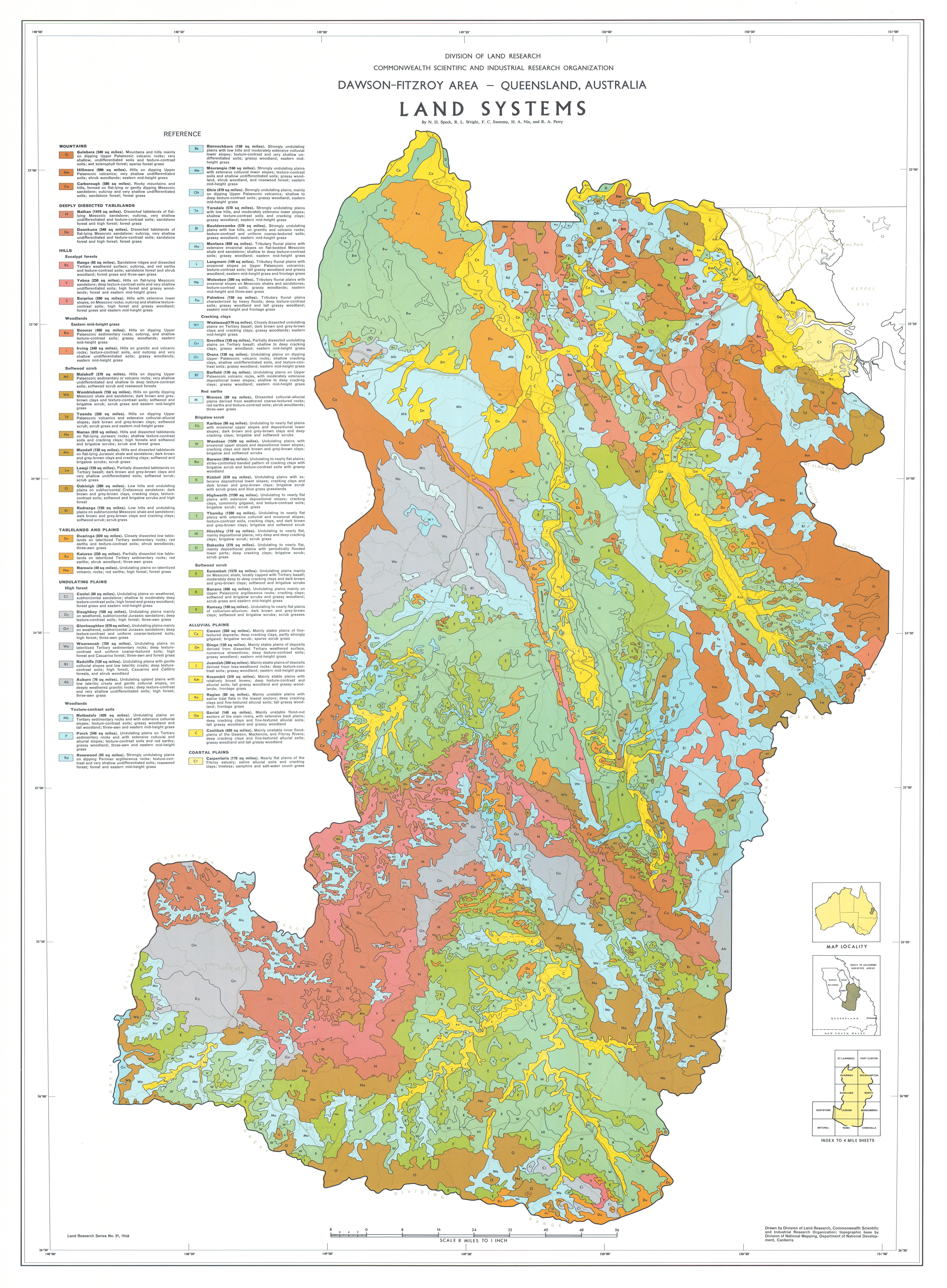
The report provides details on the 63 land systems ranging from 105 km2 to 40,665 km2, each with between five and thirteen land units. Their position in the landscape is shown on block diagrams. The survey recognised and described the relative area and distribution, landforms, soils, vegetation and land capability class of 535 land units (but see Evolving Approaches to Land Classification and Report No. 39 ).
Because some land units recur in varying proportions in a number of land systems, the report describes a concept of land facets adopted to elucidate the relationships between land units and land systems.
The report has seven individual disciplinary chapters:
- Geology — describing geological history and how land systems relate to geology
- Geomorphology — recognising two physiographic divisions, four main provinces and 23 physical regions and describing geomorphic history and how land systems relate to geomorphic categories
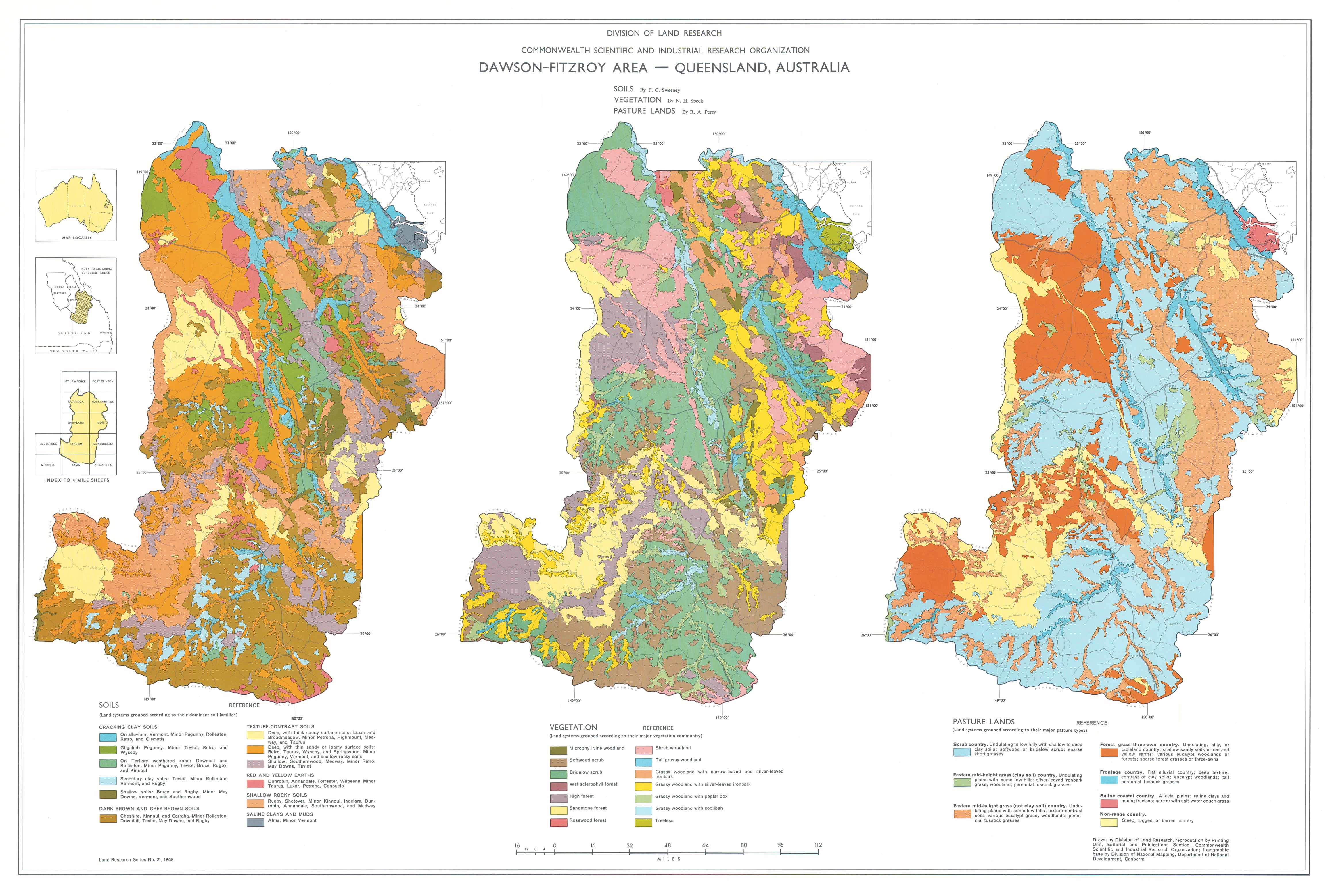
- Soils — describing seven major groups and 34 families of soils and their apportionment to land systems
- Vegetation — described in terms of subtropical rainforest, forest, woodland, and grassland and other treeless communities
- Pasture lands — described by the area of nine recognised pasture types allocated to seven classes of pasture land, with comments on their carrying capacity
- Climate — describing principal climatic controls and characteristics of rainfall, temperature, evaporation and other parameters
- Land Use — with assessment of the relationships of climate, soils and water resources to land capability and potential use, including irrigation
Map 1 — Land Systems of the Dawson–Fitzroy area, Queensland, Australia, by NH Speck, RL Wright, FC Sweeney, HA Nix and RA Perry. Scale 8 miles to 1 inch. CSIRO Land Research Series No. 21, 1968.
Map 2 — Soils, Vegetation and Pasture Lands of the Dawson–Fitzroy area, Queensland, Australia. Three maps on sheet, each scale approx. 22 miles to 1 inch: Soils by FC Sweeney; Vegetation by NH Speck; Pasture Lands by RA Perry. CSIRO Land Research Series No. 21, 1968.
The maps were digitised by the Queensland Government with permission of CSIRO. Access to the digital files can be obtained from the Queensland Department of Natural Resources and Water.
Editor's Note: The area’s population has expanded with the development of irrigated agriculture, mining and tourism, and its main town, Rockhampton, has grown from around 50,000 at the time of the survey to over 110,000 in 2011.
https://doi.org/10.1071/LRS21
© CSIRO 2010