

No. 24 Lands of the Queanbeyan–Shoalhaven Area, A.C.T. and N.S.W.
Land Research Surveys
2010(1) 1 - 175
Published: 2010
Abstract
The Queanbeyan–Shoalhaven survey was a special purpose survey covering 8,236 km2 in five major types of country. It was undertaken to provide a basis for comparison of traditional survey methods with parametric and other approaches becoming more feasible with improvements in imagery and technology. The area was conveniently located for economic and logistic efficiency.
The survey identified 34 land systems ranging from 39 km2 to 751 km2, with from two to seven land units in each. The report describes the relative area and distribution, landforms, soils, vegetation and land capability class of 156 land units with their position in the landscape shown on block diagrams.
The report has five individual disciplinary chapters:
- Geomorphology — describes geology, recognising three major relief divisions and describing landform evolution and how land systems relate to five geomorphic categories, and how relief of land units relates to position on slopes and the extent of colluvium
- Soils — describes formation and characteristics of six major groups and 32 soil families and their apportionment to land systems in relation to relief categories and lithology, together with factors that affect use of the soils
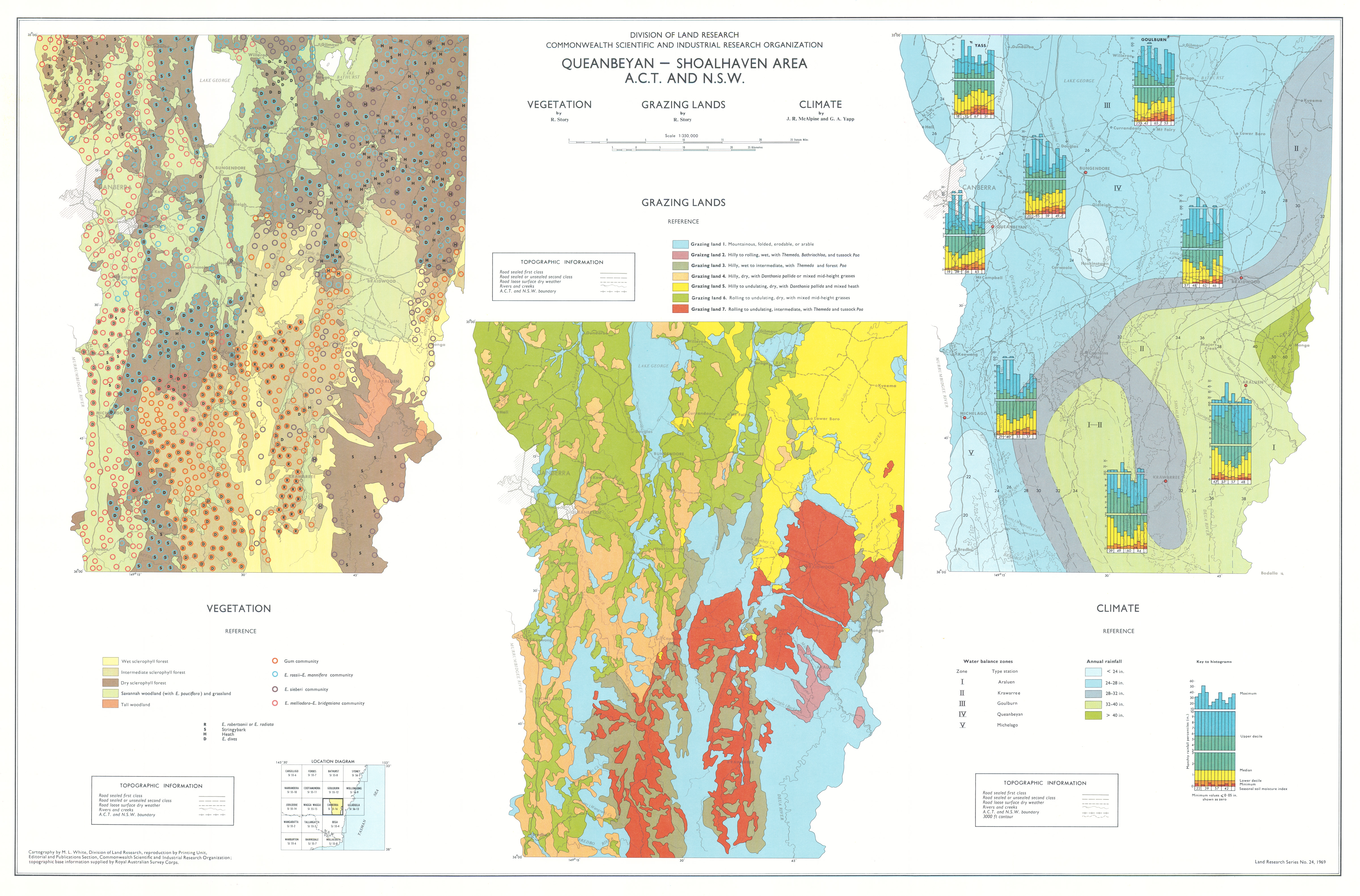
- Vegetation — notes the pervading control of climate, describes seven vegetation types and 30 communities and their distributions in the land systems, and gives descriptions for seven types of grazing land and the utilization of grasses
- Climate — describes principal features and climatic controls, and the general characteristics of rainfall, temperature, wind, relative humidity, evaporation and sunshine, with an assessment of climate in relation to plant growth and irrigation requirements based on a water balance model
- Land Use — describes the history of land use leading to the pattern of cultivation, grazing and forestry at the time of survey, details land capability for agriculture and, for the first time in mainland surveys, classifies land capability for forestry
Map 1 — Land Systems of the Queanbeyan–Shoalhaven area, ACT and NSW by RH Gunn, R Story, RW Galloway, PJB Duffy and GA Yapp. Scale 1:250,000. CSIRO Land Research Series No. 24, 1969.
Map 2 — Land Capability for Agriculture, Present Land Use, Soils and Land Capability for Forestry of the Queanbeyan–Shoalhaven area, ACT and NSW. Four maps on sheet, scale each 1:500,000: Land Capability for Agriculture by PJB Duffy; Present Land Use by PJB Duffy; Soils by RH Gunn; Land Capability for Forestry by PJB Duffy. CSIRO Land Research Series No. 24, 1969.
Map 3 — Vegetation, Grazing Lands and Climate of the Queanbeyan–Shoalhaven area, ACT and NSW. Three maps on sheet, scale each 1:350,000: Vegetation by R Story; Grazing Lands by R Story; Climate by J. McAlpine and GA Yapp. CSIRO Land Research Series No. 24, 1969.
https://doi.org/10.1071/LRS24
© CSIRO 2010