

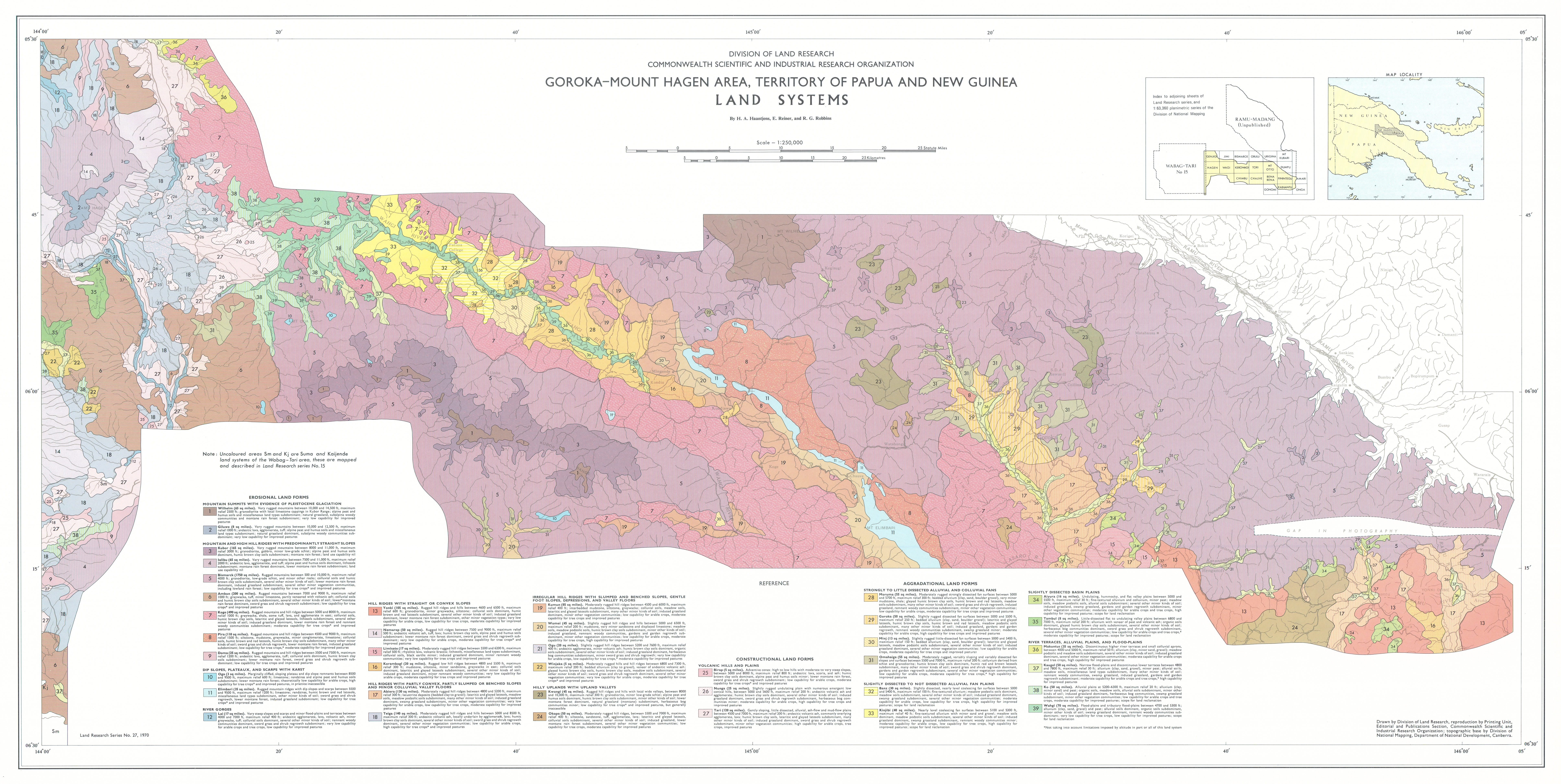
No. 27 Lands of the Goroka–Mount Hagen Area, Territory of Papua and New Guinea
Land Research Surveys
2010(1) 1 - 172
Published: 2010
Abstract
The Goroka–Mount Hagen survey covered an area of ~ 11,100 km2 which includes substantial parts of the present day Western Highlands, Simbu and Eastern Highlands Provinces and a smaller part of Madang Province with altitude ranging from about 300 m on the Ramu River to 4,510 m at the summit of Mt Wilhelm.
The survey described 39 land systems which range from 29 km2 to 1,329 km2 in 12 recognisable groups that reflect landform type. The report describes the geology, physical features, population and land use and the area, landforms, soil and drainage status, vegetation, and land class are recorded for 136 land units with their positions shown on block diagrams.
Individual disciplinary chapters describe:
- Climate — principal features and controls; rainfall, temperature and other characteristics; and water balance and plant growth
- Soils — soil classification and correlation with an adjoining survey area; main profile characteristics, organic matter, field pH and water regime of 10 soil groups and included soil families; and recorded ranges for analytical data of soil profiles
- Vegetation — ecological controls on vegetation and its distribution in relation to land systems; and classification of 11 major groups, with detail for included types
- Forest Resources — location and extent, stocking rates and access categories of forests; and details of 9 forest types in three broad zones
- Population and Land Use — population size, density and settlement patterns; and relationships of land use to environmental conditions and to land systems with notes on present and potential land use
- Agricultural Potential — describes factors affecting capability for arable and tree crops in 14 land use capability groups and outlines the distribution across land systems of eight land capability classes
Map 1 — Land Systems of the Goroka–Mount Hagen area, Territory of Papua and New Guinea by HA Haantjens, E Reiner and RG Robbins. Scale 1:250,000. CSIRO Land Research Series No. 27, 1970.
Map 2 — Forest Types and Land Use Intensity of the Goroka–Mount Hagen area, Territory of Papua and New Guinea by JC Saunders and JR McAlpine. Scale 1:250,000. CSIROLand Research Series No. 27, 1970.
Map 3 — Agricultural Land Use capability, Ruggedness and Mazimum Relief of the Goroka–Mount Hagen area, Territory of Papua and New Guinea. Two maps on sheet, each scale 1:500,000: Agricultural Land Use Capability by HA Haantjens; Ruggedness and Maximum Relief by HA Haantjens. CSIRO Land Research Series No. 27, 1970.
Map 4 — Associations of Major Soil Groups and Lithology of the Goroka–Mount Hagen area, Territory of Papua and New Guinea. Two maps on sheet, each scale 1:500,000: Associations of Major Soil Groups by HA Haantjens; Lithology by HA Haantjens. CSIRO Land Research Series No. 27, 1970.
Editor's Note: The population of about 360,000 at the time of the survey exceeds 600,000 in 2011.
https://doi.org/10.1071/LRS27
© CSIRO 2010