

Is there an inherent conflict in managing fire for people and conservation?
P. D. Bentley A and T. D. Penman A BA School of Ecosystem and Forest Sciences, University of Melbourne, Creswick, Vic. 3363, Australia.
B Corresponding author. Email: trent.penman@unimelb.edu.au
International Journal of Wildland Fire 26(6) 455-468 https://doi.org/10.1071/WF16150
Submitted: 26 March 2017 Accepted: 8 August 2017 Published: 6 June 2017
Journal Compilation © IAWF 2017 Open Access CC BY-NC-ND
Abstract
Wildfires are a natural disturbance in many ecosystems, creating challenges for land management agencies who need to simultaneously reduce risk to people and maintain ecological values. Here we use the PHOENIX RapidFire fire behaviour simulator to compare fuel treatment strategies that meet the twin objectives of reducing wildfire risk to human settlements and a fire sensitive endangered species, the koala (Phascolarctos cinereus) in south-eastern Australia. The local koala population is in decline and a conservation management plan is being prepared to exclude wildfire for a 10-year period to assist with population recovery. Twelve scenarios developed by the land management agencies were compared using four indicators: wildfire size; burn probability; impact from exposure to fire; and treatment cost. Compared with the current risk setting, three treatment scenarios were found to reduce wildfire size and burn probability concurrently to both people and koalas. These strategies worked by increasing the landscape area treated, which came with increased financial cost. However, the impact from exposure to fire for both property and koala habitat remains high. Additional complementary strategies beyond landscape fuel reductions are needed to reduce impact from exposure in the event of a wildfire.
Additional keywords: fire behaviour, fire simulation, house loss, risk, trade-off.
Introduction
Wildfires are a natural disturbance in many ecosystems around the globe, with many species dependent on fire to maintain population viability across the landscape (Bradstock et al. 2012a; Keeley et al. 2012). At a landscape scale, species respond to fire regimes rather than individual fires (Gill and McCarthy 1998). A fire regime considers the frequency, intensity, extent, seasonality, heterogeneity and size of fires in a given landscape (Gill 1975; Whelan 1995). Changes to natural fire regimes (or the variability therein) can result in significant ecological impacts on some populations, species and communities (Fox 1982; Russell-Smith et al. 2003; Andersen et al. 2005; Clarke 2008; Driscoll and Henderson 2008; Nimmo et al. 2012; Nimmo et al. 2014; Sitters et al. 2014).
A range of human factors have resulted in shifts in natural fire regimes (Bowman et al. 2009). The presence of humans in the landscape can alter patterns of ignitions (Penman et al. 2013a; Collins et al. 2015; Mann et al. 2016), often resulting in an overall increase in the number of ignitions per year (Syphard et al. 2007; Syphard et al. 2009; Plucinski et al. 2014; Price 2015). Fragmentation and manipulation of forests through expansion of agriculture and human settlements has created discontinuities in fuels thereby influencing fire spread patterns (Finney 2007; Price and Bradstock 2010; Salis et al. 2014) and surface fire behaviour (Agee et al. 2000). Furthermore, fragmentation can increase the flammability of landscapes through changes in vegetation structure along the forest edge and by shifting the vegetation composition from mesic to xeric species (Armenteras et al. 2013).
Changes in landscape flammability and fuels have led to altered fire regimes. The largest shift in fire regimes has occurred through the introduction of planned or prescribed burning. Land management agencies undertake planned burning to alter fuel load and structure in an attempt to reduce the extent and impact of future fire. Primarily the focus has been to use planned burning to reduce the risk from fire to human life and property situated within or adjacent to native vegetation (Fernandes and Botelho 2003; Penman et al. 2011). However, additional strategies are often adopted by agencies to protect life and property such as mechanical fuel treatments (Syphard et al. 2011; Syphard et al. 2012; North et al. 2015), community engagement (Eriksen and Prior 2013; Penman et al. 2015a) and fire suppression (Calkin et al. 2005; Plucinski et al. 2012; Penman et al. 2013b; Penman et al. 2014). Several studies in Australia have found that while planned burning may reduce the extent of wildfire, the net effect is an increase in overall fire extent and frequency (Boer et al. 2009; King et al. 2013; Price 2015) leading to the emergence of new landscape fire regimes. Land management agencies need to develop fire management strategies that reduce the risk of loss for people and property while maintaining ecological values (Burrows 2008; Penman et al. 2011; Thompson et al. 2011a; McCaw 2013). Strategies are generally limited to addition of fire through planned burning, or attempts at excluding fire to achieve required vegetation growth stages (e.g. Di Stefano et al. 2013) with the intent to maximise biodiversity (Parr and Andersen 2006).
Ideally, while developing fire management strategies agencies would explicitly quantify risk trade-offs to identify an optimal approach. Advances in computing and data collection has led to a unique set of tools for studying wildfire behaviour in modern landscapes. Simulation models are used to better understand how individual fires can behave under a set of conditions by varying the inputs of weather, fuel and ignition sources in different landscape settings (Finney 2005; Cary et al. 2009; Parisien et al. 2010). Combining the results from multiple fires under a range of conditions can be used to build probabilistic wildfire risk profiles for landscapes (Finney 2007; Tolhurst et al. 2008). In a research setting, many studies have used fire behaviour simulations and considered theoretical treatment approaches (e.g. nominal percentage landscape treated, reduction in ignition number) to explore ways to manipulate risk from fire in the landscape (Bradstock et al. 2012b; Haas et al. 2015; Calviño-Cancela et al. 2016). A common approach is to compare the change in risk between management scenarios using a response group, often human assets and communities (Scott et al. 2016) or threatened species (Thompson et al. 2011b; Ager et al. 2012). Very few studies have considered multiple assets in an explicit risk trade-off process (although see Ager et al. 2010; Thompson et al. 2011a; Salis et al. 2013; Driscoll et al. 2016). In application, few management agencies get to adopt such an approach to risk management and planning. However, there is increasing public pressure for government agencies to quantify risk reduction as a consequence of their actions (State of Victoria 2015).
In this study, we compare fuel treatment scenarios developed by fire management agencies to manage conservation values along with the protection of property. Our conservation values are centred on an isolated but dispersed population of an endangered iconic species, the koala (Phascolarctos cinereus). This population is in decline and a new fire management strategy of fire exclusion within koala habitat for the next 10 years has been proposed to allow the population to increase. Surrounding the forest areas where the koalas occur are scattered human properties and small settlements. Research suggests that these properties would be best protected by undertaking planned burning close to the assets (Gibbons et al. 2012; Penman et al. 2014) however this is not possible due to the presence of the koalas.
The aim of this work was to identify plausible fuel treatment strategies that meet the twin objectives of reducing wildfire risk to the koala population without increasing, and ideally decreasing, the risk to property. To compare treatments we used four indicators: wildfire size; burn probability; impact from exposure to fire; and the cost of treatment (Finney 2005; Ager et al. 2007).
Methods
Study area and fire history
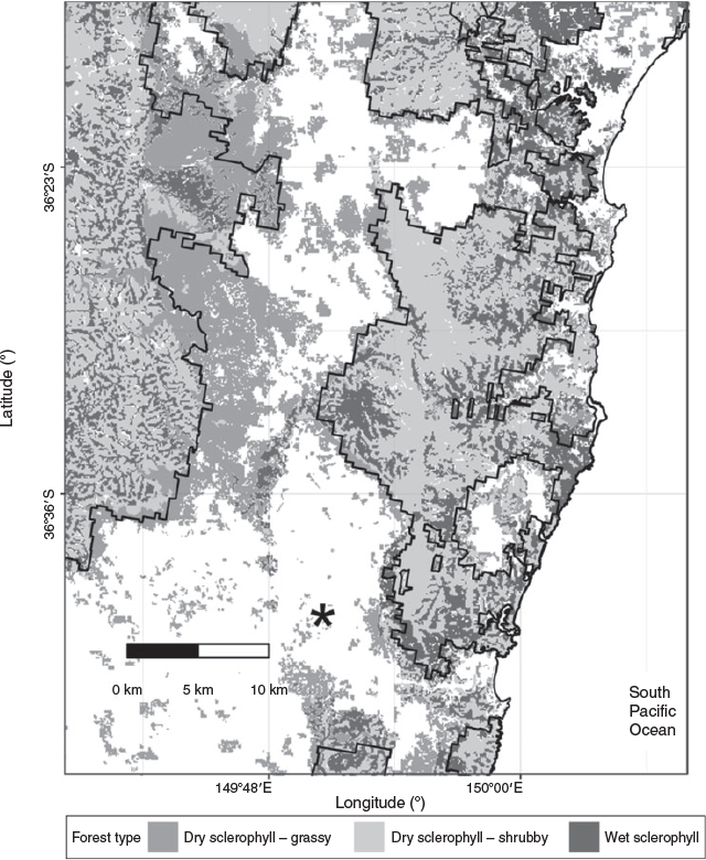
The study was set in the coastal forests (~160 000 ha) around the township of Bega in south-eastern Australia (36°7′S, 149°8′E) (Fig. 1). A complex landscape occurs in the area where the river flats contain extensive agriculture (primarily dairy), with native forests managed for either conservation or timber supply in the more rugged terrain. Scattered among the forest and agriculture are several small and medium-sized settlements. Forested areas are dominated by south-east dry sclerophyll forest (as defined by Keith 2004). These forests are dominated by silvertop ash (Eucalyptus sieberi L.A.S. Johnson), white stringy bark (E. globoidea Blakely) and blue-leaved stringybark (E. agglomerata Maiden). The mid-storey is dominated by Acacia and Allocasuarina spp. with an understorey of sclerophyllous shrubs (Keith 2004). The region receives an average annual rainfall of 600 mm (Bureau of Meteorology Bega AWS weather station number 069139).

|
The fire regime for this region is characterised by infrequent low intensity surface fires in spring, with medium to high intensity fires in spring and summer (Murphy et al. 2013). Wildfire mapping began in the area in 1952. Wildfires were recorded in 1951–52, and 1962–63 and then on an almost annual basis since 1978 with 63 mapped wildfires. Within this set, 18 large fires greater than 100 ha occurred with a mean fire size of 3705 ha (Fig. 2). Planned burning began in 1985 and has occurred since on an almost annual basis with 79 burns recorded. Within this set, 30 large burns greater than 100 ha occurred with a mean planned burn area of 426 ha (Fig. 2).
|
Property locations and koala habitat
Houses in the region tend to occur towards the coast and along major roadways. Properties used in this study were located along the boundary of the forest reserve and adjacent to koala habitat (Fig. 1). The impact of fire on people and property was measured by using address points, which were provided by the NSW Rural Fire Service (RFS). A 200-m buffer was placed around each address as precise structure locations are not recorded.
Koala habitat has been identified from recent systematic surveys of the region undertaken by the NSW Office of Environment and Heritage (OEH) (State of NSW and Office of Environment and Heritage 2016) (Fig. 1). During early European settlement koalas were widespread throughout the region however significant population declines occurred through loss of forest habitat, overhunting, vehicle collision and dog attacks (Melzer et al. 2000). Currently koalas are listed as ‘vulnerable to extinction’ under the Threatened Species Conservation Act 1995 (NSW). Koalas live in the forest canopy which makes them vulnerable to forest fires that scorch or burn the canopy. The impact of fire on koalas was measured within the footprint of koala habitat identified by the OEH.
Fire simulations
Landscape wildfire risk profiles were developed using the fire spread simulator PHOENIX RapidFire (hereafter PHOENIX) (Tolhurst et al. 2008). PHOENIX predicts the spread of fire from ignition points using inputs of weather, fuel load and terrain. PHOENIX simulates two-dimensional fire growth over complex variable landscapes using Huygens’ propagation principle of fire edge (Knight and Coleman 1993). In Australian forests the two key drivers for fire propagation are surface fire and convection driven spot fires (McArthur 1967; Gill and Zylstra 2005), both are included in PHOENIX. Surface fire behaviour is based on an adaptation of the CSIRO southern grassland fire spread model (Cheney et al. 1998) and McArthur Mk5 forest fire behaviour model (McArthur 1967; Noble et al. 1980). The spotting process is modelled using ember propagation coupled with spot fire ignitions (Saeedian et al. 2010; Chong et al. 2012). PHOENIX is used routinely for operational predictions of fire and strategic risk assessments within state agencies for eastern and southern Australia. Each of these agencies have tested the model and considered PHOENIX to provide an adequate representation of fire behaviour in their jurisdiction.
Weather conditions influence fire behaviour in PHOENIX which requires a weather stream for the simulated fire period. We selected the 10 dates with the highest daily McArthur Forest Fire Danger Index (FFDI) for the period from 1992 to 2011 from the Bega AWS weather station (site number 069139). FFDI is a composite measure that combines temperature, relative humidity,wind speed and a long-term drying index to predict the difficulty of fire suppression (McArthur 1967; Noble et al. 1980). An additional five dates from the period 2009–13 were provided by local fire managers as recent dates which presented challenging local fire weather conditions (see Table S1, Fig. S1 and Fig. S2 in online supplementary material). All weather streams covered a 24-h period beginning from midnight, to allow the model to generate stable and realistic estimates of fuel moisture. As the weather streams were taken from the recent past, we have not adjusted for climate change.
Fuel loads were calculated using fire history (time since fire), fuel type and fuel accumulation curves. In PHOENIX, major vegetation types (Keith 2004) are aggregated into fuel types based on similar fuel composition (Fig. 3). Fuel accumulation curves have been developed to model changes in fuel load where the rate of fuel accumulation decreases with time since fire using a negative exponential equation (Olson 1963). These curves have an increase followed by a plateau in fuel loads resulting in older sites having higher fuel loads. Parameters for fuel accumulation models were developed from a review of empirical literature and field data collected for local forest types by Watson (2011).
|
Fire histories were varied to represent changing approaches to fuel treatment with maximum fuel reduction occurring across the entirety of each burn block. Treatment blocks and scenarios were developed independently by the three agencies with responsibility for fire management in the study area – NSW OEH, NSW RFS and Forests NSW (Fig. 4). These strategies were designed to represent achievable fuel treatment scenarios under current or slightly increased resource allocation, as well as considering the ecological thresholds of these forests (Kenny et al. 2004). Fuel treatments were located on public land within reserve boundaries as a combination of landscape treatments and targeted treatments within koala habitat (Table 1). Landscape treatments were concentrated along the western side of the forest reserve due to koalas and property in the east. Landscape treatments were typically orientated north to south to intercept fires from the west–north-west where the most severe fire weather originates. Treatments within koala habitat were included in four scenarios to examine the effect of targeted treatments on risk reduction.

|

|
Fuel reduction and recovery was considered for a ten-year period from 2016 to 2025. Two baseline scenarios were generated for assessment of relative risk and are based on landscape fuel loads. The first represents the current risk setting in 2016 based on the contemporary fire history and the second represents future risk in the absence of fuel treatment between the present and 2026. This treatment represents a ‘do nothing’ scenario where fuel loads will reach maximum levels and we assume maximum risk.
Three ignition approaches were used (Fig. 5) – gridded, historical and weighted. In the gridded approach, we generated a regular 1 km grid of ignitions across the study landscape resulting in 1548 ignition locations. In the historical approach, we used all known historical ignitions (n = 166) provided by the NSW OEH. Finally, in the weighted approach we generated 20 000 random points and calculated ignition probability based on a model developed for similar forest types (Penman et al. 2015b), and selected the 1000 highest ignition probabilities for use in the analysis. Individual fires were ignited at 1000 hours to allow PHOENIX to generate stable and realistic estimates of fuel moisture pre-ignition. Fires were propagated for 12 h until 2200 hours, unless self-extinguished within this period. For each ignition approach all fires were allowed to run for every combination of weather and fuel treatment. This resulted in 569 940 simulated fires [(166 + 1000 + 1548) ignitions × 15 weather streams × (12 fuel treatments + 2 baseline scenarios)].

|
Analysis
All simulations were run using 180 m resolution gridded cells to optimise model performance based on the recommendations by Tolhurst et al. (2008). For each grid cell the model outputs the following metrics; ember density, convection, intensity and flame length. For each individual fire, PHOENIX reports the maximum value for each metric in each grid cell. For each combination of ignition and fuel treatment scenario, model outputs for each cell were aggregated to generate distributions to capture the combined effects of inputs and controls on landscape fire behaviour. Median cell values were reported as they are less influenced by extreme values when compared with the mean.
Risk was calculated using three metrics – fire size, burn probability and impact from exposure to fire. Fire size was calculated by summing the number of ignited cells by ignition location and treatment scenario. Mean wildfire area and 95% confidence intervals were calculated using a modified Cox’s method for log-transformations as recommended by Zhou and Gao (1997). Fires less than 100 ha were removed due to a bimodal distribution in the dataset, as these are considered small in extent compared with the total forest and asset areas. Burn probability was calculated as the number of times a cell burnt divided by the total fires, where total fires were calculated as the number of weather streams by the number of ignitions. Relative burn probability was then calculated by normalising each scenario with the BASE2026 scenario where fuel loads were the highest. Relative burn probability was used to compare ignition approaches to normalise results for differences in ignition densities and patterns.
Impact from exposure to fire was measured differently for each asset. For koalas, impact was measured by flame length, as koalas are predominantly an arboreal species. For property, we used the house loss probability equation of Tolhurst and Chong (2011) to calculate the likelihood for house loss within each cell. House loss is calculated using ember density, flame length and convection and considers the likelihood for house loss through surface fire and spotting processes (Gibbons et al. 2012).
We calculated treatment cost using the equations of Penman et al. (2014) that predicts a negative log–log relationship between area treated in hectares and cost per hectare. The total treatment cost was calculated by summing the cost of individual blocks over the ten-year period and are not adjusted for inflation. We report the average annual cost per scenario. Model outputs were processed using the R statistical environment (ver. 3.2.3, R Foundation for Statistical Computing, Vienna, Austria, see http://www.R-project.org/, accessed 4 April 2017) and the packages ggplot2 (Wickham 2009), plyr (Wickham 2011), raster (ver. 2.4–20, R. J. Hijmans, see https://cran.r-project.org/web/packages/raster/index.html, accessed 4 April 2017) and rasterVis (ver. 0.41, O. Perpinan and R. J. Hijmans, see http://oscarperpinan.github.io/rastervis/ accessed 13 April 2017).
Results
Indicator 1: wildfire size
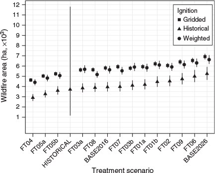
Variations in median wildfire size were consistent between ignition approaches, with the gridded ignitions (GI) and weighted ignitions (WI) estimating larger fire sizes than the historical ignitions (HI) approach (Fig. 2). Three treatments resulted in a significantly lower fire size compared with the current risk setting BASE2016 (3948 ha (HI) to 5808 ha (GI)) and the current fire management plan (FMP) FT01a (4185 ha (HI) to 5934 ha (GI)). These treatments were FT04 (2904 ha (HI) to 4630 ha (GI)), FT05a (3266 ha (HI) to 5026 ha (GI)) and FT05b (3597 ha (HI) to 5239 ha (GI)). Treatments FT04, FT05a and FT05b increased the area of fuel reduction burning over the ten-year period by a factor of 2.3, 1.8 and 1.5 compared with FT01a. The largest wildfire sizes occurred where no treatments were under taken in scenario BASE2026 (5242 ha (HI) to 6921 ha (GI)). Using Spearman’s rank correlation, wildfire size was negatively correlated with mean annual treatment area for gridded (rs = –0.94, P = 0.000), historical (rs = –0.93, P = 0.000), and weighted (rs = –0.85, P = 0.001) ignition approaches.
Indicator 2: relative burn probability
Changes in relative burn probability were similar between property and koala habitat, although the precise order of treatments and magnitude of change varied between ignition approaches (Fig. 6). Relative burn probability was similar between ignition approaches for the current risk setting BASE2016 for both property (0.72 (HI) to 0.79 (GI)) and koalas (0.70 (HI) to 0.78 (GI)). In addition, relative burn probability was similar between ignition approaches for the current FMP (FT01a) for both property (0.75 (GI) to 0.79 (HI)) and koalas (0.75 (GI) to 0.78 (HI)). This indicates a slight reduction in relative burn probability under the current FMP over the ten-year period. Three treatment (FT04, FT05a, FT05b) consistently resulted in the largest reduction in relative burn probability. Overall, FT04 resulted in the lowest relative burn probability for both property (0.51 (GI) to 0.52 (HI)) and koalas (0.46 (WI) to 0.50 (GI)) (Fig. 7).

|

|
Indicator 3: impact from wildfire
The current FMP FT01a resulted in a marginal reduction in median flame length (25.1 m (HI) to 25.9 m (GI)) compared with the current risk setting BASE2016 (26.1 m (HI) to 27.5 m (GI)) (Fig. 8). The longest median flame lengths were reported for the no treatment scenario BASE2026 (28.0 m (HI) to 28.8 m (GI)) with the lowest for a treatment scenario which treated some areas of the koala habitat FT02 (20.8 m (WI) to 21.3 m (GI)). Relative house loss probability had a slight reduction under the current FMP FT01a (0.92 (GI) to 0.93 (WI)) compared with the current risk setting BASE2016 (0.96 (HI) to 0.98 (WI)). The highest relative house loss probability occurred under the no treatment scenario BASE2026. The lower relative house loss probability occurred under FT04, which treated the largest area (0.84 (GI) to 0.85 (WI)).

|
Indicator 4: cost of treatment
The average annual area treatment ranged from 191 ha to 1718 ha while treatments cost ranged from $6581 to $77 298 per year (Fig. 9). Significant correlations exist in all ignition scenarios between relative burn probability of property and treatment area (rs = –0.67, P = 0.020 to –0.88, P = 0.000) and between the relative burn probability of koala habitat and treatment area (rs = –0.55, P = 0.071 to –0.71 P = 0.013). As investment increased, risk for both property and koala habitat decreased.

|
Discussion
We used wildfire simulations to examine the ability of a range of potential fuel treatment strategies to reduce wildfire risk to property and koala habitat. Consistent with other studies, this study showed that increasing the area of fuel treatment in a landscape resulted in a decrease in future wildfire extent and burn probability to assets (Ager et al. 2007; Finney 2007; King et al. 2008; Boer et al. 2009; Wu et al. 2013; Ager et al. 2014; Penman et al. 2014; Price et al. 2015b; Salis et al. 2016).
Increasing the area treated through planned burning and generating a measurable reduction in wildfire extent has been previously referred to as leverage (Loehle 2004). Leverage varies according to the annual extent of wildfire, extent of fuel treatment and the rate at which fuel loads recover (Price 2012). Leverage has been analysed on individual burns (Loehle 2004) and across landscapes (Boer et al. 2009; Price et al. 2012; Price et al. 2015a). In a bioregional analysis of south-eastern Australia, Price et al. (2015b) found no evidence of leverage within the study area’s bioregion for the period 1970–2010. However, they did not consider the extensive logging in the bioregion that would have had a substantial influence on the nature of fuel loads. In addition, the bioregion had very few years in which wildfire occurred. While our study considered a smaller spatial domain than Price et al. (2015b), our results suggests leverage is possible in this region as fuel treatments played a role in reducing wildfire size. Consideration is required as to how this change affects fire regimes at the decadal scale.
The spatial arrangement of treatment blocks is one of the key factors in influencing the effectiveness of encountering a wildfire where fuel loads are reduced (Price and Bradstock 2010). When a wildfire encounters a treated area with reduced fuels it is expected to reduce fire intensity and rate of spread (McCaw 2013). Treatments are considered more effective when they are placed adjacent to existing fuel breaks (e.g. roads and rivers). Lowering fuel loads is predicted to interrupt the propagation of a wildfire front (Price and Bradstock 2010). In this study, treatment strategies that produced the largest reductions in risk had a concentration of large burn blocks immediately to the west of koala habitat areas. The need for the spatial arrangement of blocks to the west was 2-fold. First, higher ignition probabilities occur in the west of the study area due to lighting along ridgelines and the higher likelihood of ignitions from roadways and human settlements, as shown in the historical and weighted ignition approaches. Second, the direction of severe fire weather in the region is from the west–north-west and is associated with hot, dry inland winds. A combination of these factors played a role in generating leverage under simulated conditions in this landscape during severe fire weather conditions.
Many treatments did not include planned burning within the koala habitat, which were often immediately adjacent to property, and high fuel loads remain in the eastern side of the forest. Even those treatments that included planned burning within some of the koala habitat resulted in little change in impact from exposure to fire. This result was due to the fact that the koala population area was larger than the fuel treatments within koala habitat. While treatment of larger areas can reduce the likelihood of a fire spreading, under more severe fire weather conditions the amount of fuels becomes less important than weather, as wildfires can still spread through areas with low fuel loads (Cary et al. 2009; Bradstock et al. 2010; Collins et al. 2014). While the probability of fire is reduced for property and koalas, the impact from exposure to fire remains high for both koalas and property. Fuel loads, topography and fire weather resulted in predicted flame lengths greater than 20 m in koala zones under all treatments. Similar high severity fires have been reported in nearby forests by Collins et al. (2014). Overall, our results are consistent with other studies that show the placement of treatments nearest to assets provides the greatest reduction in risk (Safford et al. 2009; Ager et al. 2010; Penman et al. 2014).
Planned burning is only one option to achieve risk reduction and when used in conjunction with other approaches it may improve risk outcomes. While scenarios that treat large areas have a better chance of intercepting and reducing the spread of wildfire, in this region they come with increased financial costs. Here we only compared the cost of fuel treatment; however, more cost effective risk mitigation may be achievable through integration with other strategies. These may include mechanical fuel management, ignition management, initial attack and community engagement. Mechanical removal or thinning can reduce fuel loads and alter fuel structure adjacent to property or within koala habitat to manage exposure from fire due to local high fuel loads (Penman et al. 2015a). In a simulation study Cary et al. (2009) found ignition management to have a significant influence on wildfire extent. Natural ignitions cannot be prevented, however the majority of ignitions in the study region originate from human sources which concentrate around human settlements and infrastructure (Penman et al. 2013a). Ignition management strategies such as increasing awareness and vigilance have been shown to reduce the number of ignitions in some locations (Plucinski 2014) but it is a complex societal issue that requires complex policy beyond the reach of fire management agencies (Prestemon and Butry 2008; Dickens et al. 2012). A feasible alternative to fire agencies is investing in initial attack. Initial attack is most successful with rapid response times and low fuel loads (Plucinski 2012) indicating an interaction with fuel treatment efforts (Penman et al. 2013b; Salis et al. 2014). Community engagement with householders encourages better preparation (Penman et al. 2013c) and increases the probability of structures surviving (Gibbons et al. 2012). However, the degree of involvement by property owners is linked to their perceived levels of wildfire risk (Gill et al. 2015; Penman et al. 2016). All these strategies have the potential to work independently or interactively with the fuel treatments tested here. It was beyond the scope of the study to quantify the effects of the combinations of complementary approaches.
The modelling approach was found to be useful in quantifying risk reductions from various treatments; however, there are limitations to the model. Heterogeneity within historical fire boundaries is not mapped, meaning fuel reduction from past fires is often overestimated (Penman et al. 2007). In addition, fuel treatments in the model result in a greater reduction in fuels than would be expected in reality. Furthermore, the model assumes fuel loads increase with time since fire following a negative exponential equation (Olson 1963). These curves assume an ongoing increase or a plateau in values, that is, older sites have more fuel (Watson 2011). However, few studies have attempted to quantify this. Of those that have some suggest support (McCaw et al. 2002) while others suggest a short-term increase in fuels (particularly elevated fuels) followed by an ongoing decline (Sturtevant et al. 2004; Zylstra 2013). How fuel loads accumulate and the influence of past forest disturbances such as logging are unknown and require further research. We overcame these limitations by taking a relative risk approach rather than analysing absolute values.
Conclusion
We have used a fire behaviour simulation model to compare change in wildfire risk to adjacent fire sensitive populations of people and koalas in a coastal forest of NSW, Australia. The study objectives were to identify treatment strategies that reduced risk to both people and koalas. Treatments were identified that reduced burn probability and fire size by increasing treatment area in the landscape, albeit at greater financial cost. However, the impact from exposure to fire to property and koala habitat will remain high within asset areas due to the remaining high fuel loads. Additional complementary strategies beyond landscape fuel reductions are needed to reduce impact from exposure in the event of a wildfire.
Acknowledgements
The study was funded by the NSW Office of Environment and Heritage. Treatment strategies were conceptualised in a workshop involving NSW OEH, NSW RFS and Forests NSW. Max Beukers (OEH), Phil Paterson (RFS) and Peter Kambouris (Forests NSW) assisted with generated and refined fuel treatment strategies. Rod Pietsch, Chris Allen, Marty Webster, Max Beukers and Phil Paterson provided critical comments on early drafts of the analysis and manuscript. We thank Kate Parkins, Matt Swan and the two anonymous reviewers for their feedback and direction in improving this manuscript.
References
Agee JK, Bahro B, Finney MA, Omi PN, Sapsis DB, Skinner CN, van Wagtendonk JW, Phillip Weatherspoon C (2000) The use of shaded fuelbreaks in landscape fire management. Forest Ecology and Management 127, 55–66.| The use of shaded fuelbreaks in landscape fire management.Crossref | GoogleScholarGoogle Scholar |
Ager AA, Finney MA, Kerns BK, Maffei H (2007) Modeling wildfire risk to northern spotted owl (Strix occidentalis caurina) habitat in Central Oregon, USA. Forest Ecology and Management 246, 45–56.
| Modeling wildfire risk to northern spotted owl (Strix occidentalis caurina) habitat in Central Oregon, USA.Crossref | GoogleScholarGoogle Scholar |
Ager AA, Vaillant NM, Finney MA (2010) A comparison of landscape fuel treatment strategies to mitigate wildland fire risk in the urban interface and preserve old forest structure. Forest Ecology and Management 259, 1556–1570.
| A comparison of landscape fuel treatment strategies to mitigate wildland fire risk in the urban interface and preserve old forest structure.Crossref | GoogleScholarGoogle Scholar |
Ager AA, Vaillant NM, Finney MA, Preisler HK (2012) Analyzing wildfire exposure and source–sink relationships on a fire prone forest landscape. Forest Ecology and Management 267, 271–283.
| Analyzing wildfire exposure and source–sink relationships on a fire prone forest landscape.Crossref | GoogleScholarGoogle Scholar |
Ager AAA, Day M, Finney MA, Vance-Borland K, Vaillant NM (2014) Analyzing the transmission of wildfire exposure on a fire-prone landscape in Oregon, USA. Forest Ecology and Management 334, 377–390.
| Analyzing the transmission of wildfire exposure on a fire-prone landscape in Oregon, USA.Crossref | GoogleScholarGoogle Scholar |
Andersen AN, Cook GD, Corbett LK, Douglas MM, Eager RW, Russell-Smith J, Setterfield SA, Williams RJ, Woinarski JCZ (2005) Fire frequency and biodiversity conservation in Australian tropical savannas: implications from the Kapalga fire experiment. Austral Ecology 30, 155–167.
| Fire frequency and biodiversity conservation in Australian tropical savannas: implications from the Kapalga fire experiment.Crossref | GoogleScholarGoogle Scholar |
Armenteras D, González TM, Retana J (2013) Forest fragmentation and edge influence on fire occurrence and intensity under different management types in Amazon forests. Biological Conservation 159, 73–79.
| Forest fragmentation and edge influence on fire occurrence and intensity under different management types in Amazon forests.Crossref | GoogleScholarGoogle Scholar |
Boer MM, Sadler RJ, Wittkuhn RS, McCaw L, Grierson PF (2009) Long-term impacts of prescribed burning on regional extent and incidence of wildfires – evidence from 50 years of active fire management in SW Australian forests. Forest Ecology and Management 259, 132–142.
| Long-term impacts of prescribed burning on regional extent and incidence of wildfires – evidence from 50 years of active fire management in SW Australian forests.Crossref | GoogleScholarGoogle Scholar |
Bowman DM, Balch JK, Artaxo P, Bond WJ, Carlson JM, Cochrane MA, D’Antonio CM, Defries RS, Doyle JC, Harrison SP, Johnston FH, Keeley JE, Krawchuk MA, Kull CA, Marston JB, Moritz MA, Prentice IC, Roos CI, Scott AC, Swetnam TW, van der Werf GR, Pyne SJ (2009) Fire in the earth system. Science 324, 481–484.
| Fire in the earth system.Crossref | GoogleScholarGoogle Scholar |
Bradstock RA, Hammill KA, Collins L, Price O (2010) Effects of weather, fuel and terrain on fire severity in topographically diverse landscapes of south-eastern Australia. Landscape Ecology 25, 607–619.
| Effects of weather, fuel and terrain on fire severity in topographically diverse landscapes of south-eastern Australia.Crossref | GoogleScholarGoogle Scholar |
Bradstock RA, Gill AM, Williams RJ (Eds) (2012a) ‘Flammable Australia: Fire Regimes, biodiversity and Ecosystems in a Changing World.’ (CSIRO Publishing: Melbourne, Vic., Australia)
Bradstock RA, Cary GJ, Davies I, Lindenmayer DB, Price OF, Williams RJ (2012b) Wildfires, fuel treatment and risk mitigation in Australian eucalypt forests: insights from landscape-scale simulation. Journal of Environmental Management 105, 66–75.
| Wildfires, fuel treatment and risk mitigation in Australian eucalypt forests: insights from landscape-scale simulation.Crossref | GoogleScholarGoogle Scholar |
Burrows ND (2008) Linking fire ecology and fire management in south-west Australian forest landscapes. Forest Ecology and Management 255, 2394–2406.
| Linking fire ecology and fire management in south-west Australian forest landscapes.Crossref | GoogleScholarGoogle Scholar |
Calkin D, Gebert K, Jones J, Neilson R (2005) Forest Service large fire area burned and suppression expenditure trends, 1970–2002. Journal of Forestry 103, 179–183.
Calviño-Cancela M, Chas-Amil ML, García-Martínez ED, Touza J (2016) Wildfire risk associated with different vegetation types within and outside wildland-urban interfaces. Forest Ecology and Management 372, 1–9.
| Wildfire risk associated with different vegetation types within and outside wildland-urban interfaces.Crossref | GoogleScholarGoogle Scholar |
Cary GJ, Flannigan MD, Keane RE, Bradstock RA, Davies ID, Lenihan JM, Li C, Logan KA, Parsons RA (2009) Relative importance of fuel management, ignition management and weather for area burned: evidence from five landscape–fire–succession models. International Journal of Wildland Fire 18, 147–156.
| Relative importance of fuel management, ignition management and weather for area burned: evidence from five landscape–fire–succession models.Crossref | GoogleScholarGoogle Scholar |
Cheney N, Gould J, Catchpole WR (1998) Prediction of fire spread in grasslands. International Journal of Wildland Fire 8, 1–13.
| Prediction of fire spread in grasslands.Crossref | GoogleScholarGoogle Scholar |
Chong D, Tolhurst K, Duff T 2012. PHOENIX RapidFire 4.0 convection and ember dispersal model. (Bushfire CRC: Melbourne, Vic., Australia) Available at http://www.bushfirecrc.com/sites/default/files/phoenix_4_convection_and_spotting.pdf [Verified 13 April 2017]
Clarke MF (2008) Catering for the needs of fauna in fire management: science or just wishful thinking? Wildlife Research 35, 385–394.
| Catering for the needs of fauna in fire management: science or just wishful thinking?Crossref | GoogleScholarGoogle Scholar |
Collins L, Bradstock RA, Penman TD (2014) Can precipitation influence landscape controls on wildfire severity? A case study within temperate eucalypt forests of south-eastern Australia. International Journal of Wildland Fire 23, 9–20.
| Can precipitation influence landscape controls on wildfire severity? A case study within temperate eucalypt forests of south-eastern Australia.Crossref | GoogleScholarGoogle Scholar |
Collins KM, Price OF, Penman TD (2015) Spatial patterns of wildfire ignitions in south-eastern Australia. International Journal of Wildland Fire 24, 1098–1108.
| Spatial patterns of wildfire ignitions in south-eastern Australia.Crossref | GoogleScholarGoogle Scholar |
Di Stefano J, McCarthy MA, York A, Duff TJ, Slingo J, Christie F (2013) Defining vegetation age class distributions for multispecies conservation in fire-prone landscapes. Biological Conservation 166, 111–117.
| Defining vegetation age class distributions for multispecies conservation in fire-prone landscapes.Crossref | GoogleScholarGoogle Scholar |
Dickens GL, Sugarman PA, Gannon TA (2012) ‘Firesetting and Mental Health: Theory, Research and Practice.’ (RCPsych Publications: London, UK)
Driscoll DA, Henderson MK (2008) How many common reptile species are fire specialists? A replicated natural experiment highlights the predictive weakness of a fire succession model. Biological Conservation 141, 460–471.
| How many common reptile species are fire specialists? A replicated natural experiment highlights the predictive weakness of a fire succession model.Crossref | GoogleScholarGoogle Scholar |
Driscoll DA, Bode M, Bradstock RA, Keith DA, Penman TD, Price OF (2016) Resolving future fire management conflicts using multicriteria decision making. Conservation Biology 30, 196–205.
| Resolving future fire management conflicts using multicriteria decision making.Crossref | GoogleScholarGoogle Scholar |
Eriksen C, Prior T (2013) Defining the importance of mental preparedness for risk communication and residents well-prepared for wildfire. International Journal of Disaster Risk Reduction 6, 87–97.
| Defining the importance of mental preparedness for risk communication and residents well-prepared for wildfire.Crossref | GoogleScholarGoogle Scholar |
Fernandes PM, Botelho HS (2003) A review of prescribed burning effectiveness in fire hazard reduction. International Journal of Wildland Fire 12, 117
| A review of prescribed burning effectiveness in fire hazard reduction.Crossref | GoogleScholarGoogle Scholar |
Finney MA (2005) The challenge of quantitative risk analysis for wildland fire. Forest Ecology and Management 211, 97–108.
| The challenge of quantitative risk analysis for wildland fire.Crossref | GoogleScholarGoogle Scholar |
Finney MA (2007) A computational method for optimising fuel treatment locations. International Journal of Wildland Fire 16, 702
| A computational method for optimising fuel treatment locations.Crossref | GoogleScholarGoogle Scholar |
Fox BJ (1982) Fire and mammalian secondary succession in an Australian coastal heath. Ecology 63, 1332–1341.
| Fire and mammalian secondary succession in an Australian coastal heath.Crossref | GoogleScholarGoogle Scholar |
Gibbons P, van Bommel L, Gill AM, Cary GJ, Driscoll DA, Bradstock RA, Knight E, Moritz MA, Stephens SL, Lindenmayer DB (2012) Land management practices associated with house loss in wildfires. PLoS One 7, e29212
| Land management practices associated with house loss in wildfires.Crossref | GoogleScholarGoogle Scholar |
Gill AM (1975) Fire and the Australian flora: a review. Australian Forestry 38, 4–25.
| Fire and the Australian flora: a review.Crossref | GoogleScholarGoogle Scholar |
Gill AM, McCarthy MA (1998) Intervals between prescribed fires in Australia: what intrinsic variation should apply? Biological Conservation 85, 161–169.
| Intervals between prescribed fires in Australia: what intrinsic variation should apply?Crossref | GoogleScholarGoogle Scholar |
Gill AM, Zylstra P (2005) Flammability of Australian forests. Australian Forestry 68, 87–93.
| Flammability of Australian forests.Crossref | GoogleScholarGoogle Scholar |
Gill N, Dun O, Brennan-Horley C, Eriksen C (2015) Landscape preferences, amenity, and bushfire risk in New South Wales, Australia. Environmental Management 56, 738–753.
| Landscape preferences, amenity, and bushfire risk in New South Wales, Australia.Crossref | GoogleScholarGoogle Scholar |
Haas JR, Calkin DE, Thompson MP (2015) Wildfire risk transmission in the Colorado Front Range, USA. Risk Analysis 35, 226–240.
| Wildfire risk transmission in the Colorado Front Range, USA.Crossref | GoogleScholarGoogle Scholar |
Keeley JE, Bond WJ, Bradstock RA, Pausas JG, Rundel PW (2012) ‘Fire in Mediterranean Ecosystems: Ecology, Evolution and Management.’ (Cambridge University Press: Cambridge, UK)
Keith DA (2004) ‘Ocean Shores to Desert Dunes: the Native Vegetation of NSW and the ACT’ (Department of Environment and Conservation: Sydney, NSW, Australia)
Kenny BJ, Sutherland EK, Tasker EM, Bradstock RA 2004. Guidelines for ecologically sustainable fire management. (NSW National Parks and Wildlife Service: Sydney, NSW, Australia)
King KJ, Bradstock RA, Cary GJ, Chapman J, Marsden-Smedley JB (2008) The relative importance of fine-scale fuel mosaics on reducing fire risk in south-west Tasmania, Australia. International Journal of Wildland Fire 17, 421
| The relative importance of fine-scale fuel mosaics on reducing fire risk in south-west Tasmania, Australia.Crossref | GoogleScholarGoogle Scholar |
King KJ, Cary GJ, Bradstock RA, Marsden-Smedley JB (2013) Contrasting fire responses to climate and management: insights from two Australian ecosystems. Global Change Biology 19, 1223–1235.
| Contrasting fire responses to climate and management: insights from two Australian ecosystems.Crossref | GoogleScholarGoogle Scholar |
Knight I, Coleman J (1993) A fire perimeter expansion algorithm-based on Huygen’s wavelet propagation. International Journal of Wildland Fire 3, 73–84.
| A fire perimeter expansion algorithm-based on Huygen’s wavelet propagation.Crossref | GoogleScholarGoogle Scholar |
Loehle C (2004) Applying landscape principles to fire hazard reduction. Forest Ecology and Management 198, 261–267.
| Applying landscape principles to fire hazard reduction.Crossref | GoogleScholarGoogle Scholar |
Mann ML, Batllori E, Moritz MA, Waller EK, Berck P, Flint AL, Flint LE, Dolfi E (2016) Incorporating anthropogenic influences into fire probability models: effects of human activity and climate change on fire activity in California. PLoS One 11, e0153589
| Incorporating anthropogenic influences into fire probability models: effects of human activity and climate change on fire activity in California.Crossref | GoogleScholarGoogle Scholar |
McArthur AG 1967. Fire behaviour in eucalypt forests, leaflet number 107. (Forestry and Timber Bureau: Canberra, ACT, Australia)
McCaw WL (2013) Managing forest fuels using prescribed fire – a perspective from southern Australia. Forest Ecology and Management 294, 217–224.
| Managing forest fuels using prescribed fire – a perspective from southern Australia.Crossref | GoogleScholarGoogle Scholar |
McCaw WL, Neal JE, Smith RH (2002) Stand characteristics and fuel accumulation in a sequence of even-aged Karri (Eucalyptus diversicolor) stands in south-west Western Australia. Forest Ecology and Management 158, 263–271.
| Stand characteristics and fuel accumulation in a sequence of even-aged Karri (Eucalyptus diversicolor) stands in south-west Western Australia.Crossref | GoogleScholarGoogle Scholar |
Melzer A, Carrick F, Menkhorst P, Lunney D, St John B (2000) Overview, critical assessment, and conservation implications of koala distribution and abundance. Conservation Biology 14, 619–628.
| Overview, critical assessment, and conservation implications of koala distribution and abundance.Crossref | GoogleScholarGoogle Scholar |
Murphy BP, Bradstock RA, Boer MM, Carter J, Cary GJ, Cochrane MA, Fensham RJ, Russell-Smith J, Williamson GJ, Bowman DMJS, Ladiges P (2013) Fire regimes of Australia: a pyrogeographic model system. Journal of Biogeography 40, 1048–1058.
| Fire regimes of Australia: a pyrogeographic model system.Crossref | GoogleScholarGoogle Scholar |
Nimmo DG, Kelly LT, Spence-Bailey LM, Watson SJ, Haslem A, White JG, Clarke MF, Bennett AF (2012) Predicting the century-long post-fire responses of reptiles. Global Ecology and Biogeography 21, 1062–1073.
| Predicting the century-long post-fire responses of reptiles.Crossref | GoogleScholarGoogle Scholar |
Nimmo DG, Kelly LT, Farnsworth LM, Watson SJ, Bennett AF (2014) Why do some species have geographically varying responses to fire history? Ecography 37, 805–813.
| Why do some species have geographically varying responses to fire history?Crossref | GoogleScholarGoogle Scholar |
Noble I, Gill A, Bary G (1980) McArthur’s fire‐danger meters expressed as equations. Australian Journal of Ecology 5, 201–203.
| McArthur’s fire‐danger meters expressed as equations.Crossref | GoogleScholarGoogle Scholar |
North M, Brough A, Long J, Collins B, Bowden P, Yasuda D, Miller J, Sugihara N (2015) Constraints on mechanized treatment significantly limit mechanical fuels reduction extent in the Sierra Nevada. Journal of Forestry 113, 40–48.
| Constraints on mechanized treatment significantly limit mechanical fuels reduction extent in the Sierra Nevada.Crossref | GoogleScholarGoogle Scholar |
Olson JS (1963) Energy storage and the balance of producers and decomposers in ecological systems. Ecology 44, 322–331.
| Energy storage and the balance of producers and decomposers in ecological systems.Crossref | GoogleScholarGoogle Scholar |
Parisien M-A, Miller C, Ager AA, Finney MA (2010) Use of artificial landscapes to isolate controls on burn probability. Landscape Ecology 25, 79–93.
| Use of artificial landscapes to isolate controls on burn probability.Crossref | GoogleScholarGoogle Scholar |
Parr CL, Andersen AN (2006) Patch mosaic burning for biodiversity conservation: a critique of the pyrodiversity paradigm. Conservation Biology 20, 1610–1619.
| Patch mosaic burning for biodiversity conservation: a critique of the pyrodiversity paradigm.Crossref | GoogleScholarGoogle Scholar |
Penman TD, Kavanagh RP, Binns DL, Melick DR (2007) Patchiness of prescribed burns in dry sclerophyll eucalypt forests in south-eastern Australia. Forest Ecology and Management 252, 24–32.
| Patchiness of prescribed burns in dry sclerophyll eucalypt forests in south-eastern Australia.Crossref | GoogleScholarGoogle Scholar |
Penman TD, Christie FJ, Andersen AN, Bradstock RA, Cary GJ, Henderson MK, Price O, Tran C, Wardle GM, Williams RJ, York A (2011) Prescribed burning: how can it work to conserve the things we value? International Journal of Wildland Fire 20, 721–733.
| Prescribed burning: how can it work to conserve the things we value?Crossref | GoogleScholarGoogle Scholar |
Penman TD, Bradstock RA, Price O (2013a) Modelling the determinants of ignition in the Sydney Basin, Australia: implications for future management. International Journal of Wildland Fire 22, 469–478.
| Modelling the determinants of ignition in the Sydney Basin, Australia: implications for future management.Crossref | GoogleScholarGoogle Scholar |
Penman TD, Collins L, Price OF, Bradstock RA, Metcalf S, Chong DM (2013b) Examining the relative effects of fire weather, suppression and fuel treatment on fire behaviour – a simulation study. Journal of Environmental Management 131, 325–333.
| Examining the relative effects of fire weather, suppression and fuel treatment on fire behaviour – a simulation study.Crossref | GoogleScholarGoogle Scholar |
Penman TD, Eriksen C, Blanchi R, Chladil M, Gill AM, Haynes K, Leonard J, McLennan J, Bradstock RA (2013c) Defining adequate means of residents to prepare property for protection from wildfire. International Journal of Disaster Risk Reduction 6, 67–77.
| Defining adequate means of residents to prepare property for protection from wildfire.Crossref | GoogleScholarGoogle Scholar |
Penman TD, Bradstock RA, Price OF (2014) Reducing wildfire risk to urban developments: simulation of cost-effective fuel treatment solutions in south eastern Australia. Environmental Modelling & Software 52, 166–175.
| Reducing wildfire risk to urban developments: simulation of cost-effective fuel treatment solutions in south eastern Australia.Crossref | GoogleScholarGoogle Scholar |
Penman TD, Nicholson AE, Bradstock RA, Collins L, Penman SH, Price OF (2015a) Reducing the risk of house loss due to wildfires. Environmental Modelling & Software 67, 12–25.
| Reducing the risk of house loss due to wildfires.Crossref | GoogleScholarGoogle Scholar |
Penman TD, Parkins KA, Mascaro S, Chong D, Bradstock RA 2015b. National fire danger rating system probabilistic framework project, Final report year three. (Bushfire and Natural Hazards Cooperative Research Centre: Canberra).
Penman TD, Eriksen CE, Horsey B, Bradstock RA (2016) How much does it cost residents to prepare their property for wildfire? International Journal of Disaster Risk Reduction 16, 88–98.
| How much does it cost residents to prepare their property for wildfire?Crossref | GoogleScholarGoogle Scholar |
Plucinski MP (2012) Factors affecting containment area and time of Australian forest fires featuring aerial suppression. Forest Science 58, 390–398.
| Factors affecting containment area and time of Australian forest fires featuring aerial suppression.Crossref | GoogleScholarGoogle Scholar |
Plucinski MP (2014) The timing of vegetation fire occurrence in a human landscape. Fire Safety Journal 67, 42–52.
| The timing of vegetation fire occurrence in a human landscape.Crossref | GoogleScholarGoogle Scholar |
Plucinski MP, McCarthy GJ, Hollis JJ, Gould JS (2012) The effect of aerial suppression on the containment time of Australian wildfires estimated by fire management personnel. International Journal of Wildland Fire 21, 219–229.
| The effect of aerial suppression on the containment time of Australian wildfires estimated by fire management personnel.Crossref | GoogleScholarGoogle Scholar |
Plucinski MP, McCaw WL, Gould JS, Wotton BM (2014) Predicting the number of daily human-caused bushfires to assist suppression planning in south-west Western Australia. International Journal of Wildland Fire 23, 520–531.
| Predicting the number of daily human-caused bushfires to assist suppression planning in south-west Western Australia.Crossref | GoogleScholarGoogle Scholar |
Prestemon JP, Butry DT (2008) Wildland arson management. In ‘The Economics of Forest Disturbances: Wildfires, Storms, and Invasive Species.’ (Eds TP Holmes, JP Prestemon, KL Abt) pp. 123–147. (Springer: Dordrecht, Netherlands)
Price O (2012) The drivers of effectiveness of prescribed fire treatment. Forest Science 58, 606–617.
| The drivers of effectiveness of prescribed fire treatment.Crossref | GoogleScholarGoogle Scholar |
Price OF (2015) Potential role of ignition management in reducing unplanned burning in Arnhem Land, Australia. Austral Ecology 40, 857–868.
| Potential role of ignition management in reducing unplanned burning in Arnhem Land, Australia.Crossref | GoogleScholarGoogle Scholar |
Price OF, Bradstock RA (2010) The effect of fuel age on the spread of fire in sclerophyll forest in the Sydney region of Australia. International Journal of Wildland Fire 19, 35–45.
| The effect of fuel age on the spread of fire in sclerophyll forest in the Sydney region of Australia.Crossref | GoogleScholarGoogle Scholar |
Price OF, Russell-Smith J, Watt F (2012) The influence of prescribed fire on the extent of wildfire in savanna landscapes of western Arnhem Land, Australia. International Journal of Wildland Fire 21, 297–305.
| The influence of prescribed fire on the extent of wildfire in savanna landscapes of western Arnhem Land, Australia.Crossref | GoogleScholarGoogle Scholar |
Price OF, Pausas JG, Govender N, Flannigan M, Fernandes PM, Brooks ML, Bird RB (2015a) Global patterns in fire leverage: the response of annual area burnt to previous fire. International Journal of Wildland Fire 24, 297–306.
| Global patterns in fire leverage: the response of annual area burnt to previous fire.Crossref | GoogleScholarGoogle Scholar |
Price OF, Penman TD, Bradstock RA, Boer MM, Clarke H (2015b) Biogeographical variation in the potential effectiveness of prescribed fire in south-eastern Australia. Journal of Biogeography 42, 2234–2245.
| Biogeographical variation in the potential effectiveness of prescribed fire in south-eastern Australia.Crossref | GoogleScholarGoogle Scholar |
Russell-Smith J, Whitehead PJ, Cook GD, Hoare JL (2003) Response of eucalyptus-dominated savanna to frequent fires: lessons from Munmarlary, 1973–1996. Ecological Monographs 73, 349–375.
| Response of eucalyptus-dominated savanna to frequent fires: lessons from Munmarlary, 1973–1996.Crossref | GoogleScholarGoogle Scholar |
Saeedian P, Moran B, Tolhurst K, Halgamuge MN (2010) Prediction of high-risk areas in wildland fires. In ‘Fifth International Conference on Information and Automation for Sustainability’, 17–19 December 2010, Colombo, Sri Lanka. pp. 399–403
Safford HD, Schmidt DA, Carlson CH (2009) Effects of fuel treatments on fire severity in an area of wildland–urban interface, Angora Fire, Lake Tahoe Basin, California. Forest Ecology and Management 258, 773–787.
| Effects of fuel treatments on fire severity in an area of wildland–urban interface, Angora Fire, Lake Tahoe Basin, California.Crossref | GoogleScholarGoogle Scholar |
Salis M, Ager AA, Arca B, Finney MA, Bacciu V, Duce P, Spano D (2013) Assessing exposure of human and ecological values to wildfire in Sardinia, Italy. International Journal of Wildland Fire 22, 549–565.
| Assessing exposure of human and ecological values to wildfire in Sardinia, Italy.Crossref | GoogleScholarGoogle Scholar |
Salis M, Ager AA, Finney MA, Arca B, Spano D (2014) Analyzing spatiotemporal changes in wildfire regime and exposure across a Mediterranean fire-prone area. Natural Hazards 71, 1389
| Analyzing spatiotemporal changes in wildfire regime and exposure across a Mediterranean fire-prone area.Crossref | GoogleScholarGoogle Scholar |
Salis M, Laconi M, Ager AA, Alcasena FJ, Arca B, Lozano O, Fernandes de Oliveira A, Spano D (2016) Evaluating alternative fuel treatment strategies to reduce wildfire losses in a Mediterranean area. Forest Ecology and Management 368, 207–221.
| Evaluating alternative fuel treatment strategies to reduce wildfire losses in a Mediterranean area.Crossref | GoogleScholarGoogle Scholar |
Scott JH, Thompson MP, Gilbertson-Day JW (2016) Examining alternative fuel management strategies and the relative contribution of National Forest System land to wildfire risk to adjacent homes – a pilot assessment on the Sierra National Forest, California, USA. Forest Ecology and Management 362, 29–37.
| Examining alternative fuel management strategies and the relative contribution of National Forest System land to wildfire risk to adjacent homes – a pilot assessment on the Sierra National Forest, California, USA.Crossref | GoogleScholarGoogle Scholar |
Sitters H, Christie FJ, Di Stefano J, Swan M, Penman T, Collins PC, York A (2014) Avian responses to the diversity and configuration of fire age classes and vegetation types across a rainfall gradient. Forest Ecology and Management 318, 13–20.
| Avian responses to the diversity and configuration of fire age classes and vegetation types across a rainfall gradient.Crossref | GoogleScholarGoogle Scholar |
State of NSW and Office of Environment and Heritage 2016. 2012–14 Koala survey report in coastal forests of south-eastern NSW – Bermagui/Mumbulla area, corridors and core habitat for koalas. (State of NSW and Office of Environment and Heritage: Sydney, NSW, Australia)
State of Victoria 2015. Safer together: a new approach to reducing the risk of bushfire in Victoria. Victorian State Government response to the review of performance targets for bushfire fuel management on public land. Available at http://www.delwp.vic.gov.au/__data/assets/pdf_file/0004/319531/DELWP_SaferTogether_FINAL_17Nov15.pdf [Verified 4 April 2017]
Sturtevant B, Zollner P, Gustafson E, Cleland D (2004) Human influence on the abundance and connectivity of high-risk fuels in mixed forests of northern Wisconsin, USA. Landscape Ecology 19, 235
| Human influence on the abundance and connectivity of high-risk fuels in mixed forests of northern Wisconsin, USA.Crossref | GoogleScholarGoogle Scholar |
Syphard AD, Radeloff VC, Keeley JE, Hawbaker TJ, Clayton MK, Stewart SI, Hammer RB (2007) Human influence on California fire regimes. Ecological Applications 17, 1388–1402.
| Human influence on California fire regimes.Crossref | GoogleScholarGoogle Scholar |
Syphard AD, Radeloff VC, Hawbaker TJ, Stewart SI (2009) Conservation threats due to human-caused increases in fire frequency in Mediterranean-climate ecosystems. Conservation Biology 23, 758–769.
| Conservation threats due to human-caused increases in fire frequency in Mediterranean-climate ecosystems.Crossref | GoogleScholarGoogle Scholar |
Syphard AD, Scheller RM, Ward BC, Spencer WD, Strittholt JR (2011) Simulating landscape-scale effects of fuels treatments in the Sierra Nevada, California, USA. International Journal of Wildland Fire 20, 364–383.
| Simulating landscape-scale effects of fuels treatments in the Sierra Nevada, California, USA.Crossref | GoogleScholarGoogle Scholar |
Syphard AD, Keeley JE, Massada AB, Brennan TJ, Radeloff VC (2012) Housing arrangement and location determine the likelihood of housing loss due to wildfire. PLoS One 7, e33954
| Housing arrangement and location determine the likelihood of housing loss due to wildfire.Crossref | GoogleScholarGoogle Scholar |
Thompson MP, Calkin DE, Finney MA, Ager AA, Gilbertson-Day JW (2011a) Integrated national-scale assessment of wildfire risk to human and ecological values. Stochastic Environmental Research and Risk Assessment 25, 761–780.
| Integrated national-scale assessment of wildfire risk to human and ecological values.Crossref | GoogleScholarGoogle Scholar |
Thompson MP, Calkin DE, Gilbertson-Day JW, Ager AA (2011b) Advancing effects analysis for integrated, large-scale wildfire risk assessment. Environmental Monitoring and Assessment 179, 217–239.
| Advancing effects analysis for integrated, large-scale wildfire risk assessment.Crossref | GoogleScholarGoogle Scholar |
Tolhurst KG, Chong DM (2011) Assessing potential house losses using PHOENIX RapidFire. In ‘Proceedings of Bushfire CRC & AFAC 2011 Conference Science Day’, 1 September 2011, Sydney, NSW, Australia. (Ed. RP Thornton) pp. 74–76. (Bushfire Cooperative Research Centre: Sydney, NSW, Australia) Available at http://www.bushfirecrc.com/sites/default/files/managed/resource/74-86_assessing_potential_house_losses.pdf [Verified 13 April 2017]
Tolhurst K, Shields B, Chong D (2008) Phoenix: development and application of a bushfire risk management tool. Australian Journal of Emergency Management 23, 47–54.
Watson PJ (2011) Fuel load dynamics in NSW vegetation. Part 1: forests and grassy woodlands. Report to the NSW Rural Fire Service. Centre for Environmental Risk Management of Bushfires, University of Wollongong, NSW, Australia.
Whelan RJ (1995) ‘The Ecology of Fire.’ (Cambridge University Press: Melbourne, Vic., Australia)
Wickham H (2009) ‘ggplot2: Elegant Graphics for Data Analysis.’ (Springer-Verlag: New York, NY, USA)
Wickham H (2011) The split-apply-combine strategy for data analysis. Journal of Statistical Software 40, 1–29.
| The split-apply-combine strategy for data analysis.Crossref | GoogleScholarGoogle Scholar |
Wu Z, He HS, Liu Z, Liang Y (2013) Comparing fuel reduction treatments for reducing wildfire size and intensity in a boreal forest landscape of northeastern China. The Science of the Total Environment 454–455, 30–39.
| Comparing fuel reduction treatments for reducing wildfire size and intensity in a boreal forest landscape of northeastern China.Crossref | GoogleScholarGoogle Scholar |
Zhou XH, Gao S (1997) Confidence intervals for the log-normal mean. Statistics in Medicine 16, 783–790.
| Confidence intervals for the log-normal mean.Crossref | GoogleScholarGoogle Scholar |
Zylstra P (2013) The historical influence of fire on the flammability of subalpine snowgum forest and woodland. Victorian Naturalist 130, 232–239.