

On the extent of fire-induced forest degradation in Mato Grosso, Brazilian Amazon, in 2000, 2005 and 2010
Jukka Miettinen A C D , Yosio E. Shimabukuro A B , René Beuchle A , Rosana C. Grecchi A , Marcela Velasco Gomez A , Dario Simonetti A and Frédéric Achard AA European Commission, Joint Research Centre (JRC), Institute for Environment and Sustainability (IES), Forest Resource and Climate Unit, 21027 Ispra, Italy.
B Brazilian National Institute for Space Research (INPE), 12227 São José dos Campos, Brazìl.
C Present address: Centre for Remote Imaging, Sensing and Processing, National University of Singapore, 119076 Singapore, Singapore.
D Corresponding author. Email: jimietti@yahoo.com
International Journal of Wildland Fire 25(2) 129-136 https://doi.org/10.1071/WF15036
Submitted: 6 February 2015 Accepted: 20 October 2015 Published: 23 December 2015
Journal Compilation © IAWF 2016
Abstract
In this paper we analyse the extent of fire-induced forest degradation in Mato Grosso State, Brazil. We utilise a sample based approach used in a previous pan-tropical deforestation survey to derive information on land cover and burned areas in the two major biomes of Mato Grosso: Amazon and Cerrado. Land cover and burned area are mapped for three years (2000–2005–2010) over 77 sample sites (10 000 ha each) distributed systematically throughout the state which covers 90.337 Mha. Our results indicate continuing forest degradation by fires in the state and potentially increasing fire susceptibility of the Amazon forests, regardless of the decrease in deforestation. 2010 witnessed the most extensive fire-induced forest degradation (~300 000 ha) in the forests of the Amazon biome among the study years, regardless of the fact that the fire season was less severe than in 2005. Deforestation in the Amazon biome in Mato Grosso dropped from 590 000 ha year–1 in the 2000–2005 period to 190 000 ha year–1 in the second half of the decade. The findings of this study advocate the inclusion of forest fire effects into carbon accounting initiatives.
Additional keywords: forest fires, Landsat, sampling, tropical forest.
Introduction
The majority of carbon emissions from anthropogenic land cover changes can be attributed to deforestation (Achard et al. 2014). However, due to the increasing amount of anthropogenic activities in tropical forests, the importance of forest degradation in the context of tropical forest carbon emissions is increasing. It has been estimated that in the Brazilian Amazon emission levels from forest degradation may reach up to 40% of the emissions from deforestation (Berenguer et al. 2014).
Forest degradation can be generally defined as long-term disturbance in forested areas (Simula 2009) and it typically causes changes in the physical structure of the forest, often leading to reduction in canopy cover and biomass. In the Amazonian region forest degradation is mainly associated with selective logging activities and forest fires (Asner et al. 2005; Eva et al. 2012; Souza et al. 2013). Initial disturbance makes forests vulnerable to further degradation potentially ending in deforestation (Asner et al. 2006; Matricardi et al. 2010; Numata et al. 2010). While the level of selective logging activities in the Amazon has been widely studied and well documented (e.g. Asner et al. 2005; Hosonuma et al. 2012; Souza et al. 2013), the extent of fire-induced forest degradation is less studied and the analyses have been typically limited either by small study areas or coarse spatial resolution (e.g. Matricardi et al. 2010; Morton et al. 2013).
Fire is widely used in conversion of natural vegetation into agricultural fields and pasture areas in Mato Grosso, and for the subsequent maintenance of deforested areas (Cochrane et al. 1999; Pivello 2011). These land management fires occasionally escape beyond their intended extent, leading to uncontrolled wildfires. While natural fire occurrences in the humid Amazonian forests are extremely rare (Cochrane 2003), the seasonally dry Cerrado and Pantanal biomes (IBGE-MMA 2004) experience also some natural fires caused by lightning strikes. However, even in these biomes naturally occurring fires typically result only in small burn scars due to the oncoming rain, while anthropogenic fires in the peak dry season cause the majority of the burning (Pivello 2011). Regardless of the affected biome, fires alter the vegetation structure as well as affect the biological diversity and nutrient flux in a variety of ways (Dwyer et al. 2000). Furthermore, fires cause a wide range of secondary effects including human health problems, economic losses and carbon emissions, potentially leading to long-term reduction of carbon stock (Tahir Qadri 2001; van der Werf et al. 2010; Barlow et al. 2012).
Fire detection and burned area mapping are most typically performed with coarse spatial resolution (>250 m) satellite data which offer high temporal frequency enabling near real time monitoring of the development of the burning season (Setzer and Pereira 1991; Tansey et al. 2008; Giglio et al. 2009; Morton et al. 2011). However, burned area monitoring limited to coarse spatial resolution data may distort both the overall burned area estimate and the spatial distribution of burned area (Laris 2005; Miettinen and Liew 2009). Medium spatial resolution (5–30 m) satellite data offers means to analyse the extent, distribution and characteristics of burned areas with higher reliability. But it is difficult to obtain full coverage medium resolution datasets suitable for mapping burned areas, which are detectable only for a limited period of time (see e.g. Souza et al. 2013), over large areas in the humid tropics (Miettinen et al. 2013). For this reason, a sampling based approach utilising medium resolution Landsat data has been developed in the Amazonian region (Shimabukuro et al. 2014). Regardless of the limitations often associated with sampling based approaches (see e.g. Tucker and Townshend 2000), systematic sampling approaches have been shown to be suitable for forest change monitoring from global to territorial scales with appropriate sampling schemes (Eva et al. 2010).
In this study we analyse the extent of burned area and its distribution between different land cover types in the two main biomes of Mato Grosso State, Brazil, using a systematic sampling approach with medium resolution satellite imagery. We estimate the extent of land cover types and burned areas in 2000, 2005 and 2010, from a set of sample sites of 10 km × 10 km in size located at each full degree confluence of latitude and longitude. Utilising Landsat imagery we analyse the extent of fire-induced forest degradation (i.e. area of burned forest) and contrast this to the changes in the level of deforestation.
Materials and methods
Study area
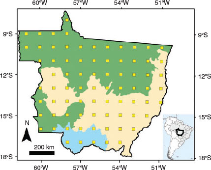
The study area corresponds to the Mato Grosso State, in Brazil (Fig. 1), which comprises an area of 90.337 Mha. Due to variable climate, terrain relief, precipitation patterns and length of the dry season, the State of Mato Grosso contains a complex biodiversity, resulting in two major vegetation types of the Bioma Amazônia (i.e. Amazon biome) and Bioma Cerrado (i.e. Cerrado biome) according to the official Brazilian national classification system (IBGE-MMA 2004). The natural vegetation in the Amazon biome consists of humid evergreen fire-sensitive forests, while the Cerrado natural vegetation is a mixture of evergreen gallery forests and open canopy fire-adapted deciduous forests, shrub and grasslands (Cochrane 2003; Pivello 2011; Beuchle et al. 2015). Due to the different fire-adaptability of Cerrado and Amazon biomes, and therefore potential differences in the effects of fires, we perform all the analyses separately for the two biomes in this study. The Amazon biome covers ~48 Mha in Mato Grosso (54%), while the Cerrado covers ~36 Mha (40%). In addition, ~6 Mha km2 (6%) of Mato Grosso is covered by Pantanal wetlands biome (Bioma Pantanal; IBGE-MMA 2004), which is another fire-adapted vegetation type similarly to Cerrado (Pivello 2011). In order to avoid very small number of sample plots, the Pantanal areas are included in the Cerrado during the analyses performed in this study.
|
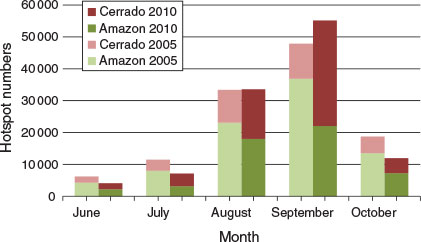
The forests of Mato Grosso are partly located in the ‘arc of deforestation’ at the southern extent of the Brazilian Legal Amazon and have experienced one of the highest annual deforestation rates among the states in Brazil (INPE 2014). Forest clearance causes, among others, habitat fragmentation, which leaves the remaining forest more vulnerable to edge effects such as fire (Cochrane and Laurance 2002). In consequence, the fire events are likely to happen more frequently on the border of deforestation activities. Temporally, the fires in Mato Grosso are highly concentrated in the burning season between June and October, with 88% of all MODerate Resolution Imaging Spectroradiometer (MODIS) active fire detections in the state from 2003 to 2010 recorded during these months, based on the datasets used in this study (Giglio et al. 2003; FIRMS 2014; please see more details below).
Landsat TM data
Altogether 252 Landsat 7 Enhanced Thematic Mapper (ETM+) (for year 2000) and Landsat 5 Thematic Mapper (TM) (for years 2005 and 2010) scenes were used to cover the 77 sample sites (10 km × 10 km in size) located at each full degree confluence of latitude and longitude in Mato Grosso State at six different times over the decade. 42 Landsat scenes were needed to cover all of the sample sites in the state of Mato Grosso. Two different sets of imagery were used to map (i) land cover (pre-fire dataset) and (ii) burned area (post-fire dataset). The land cover mapping dataset was based on the 126 (3 × 42) images used in a previous pan-tropical deforestation survey (Achard et al. 2014). However, due to the fact that the pan-tropical survey used the most cloud free images within the target year +- 1 year, 56 images (21, 22 and 13 for 2000, 2005 and 2010 respectively) in the dataset were acquired only after the fires of the target year, typically during the dry season of the following year (Beuchle et al. 2011). Therefore, we replaced the 56 Landsat images with images collected during early dry season in the year of the burning. The second Landsat dataset (3 × 42 = 126 images) was collected by selecting late fire season images and was used in this study for burned area mapping.
MOD/MYD14 active fire dataset
The MODIS hotspots (MOD/MYD14 version 5.1) data were downloaded from the Fire Information for Resource Management System (FIRMS) website (FIRMS 2014) for the period of Jan 2003–Dec 2010. The fire detection is based on a contextual fire detection algorithm, which utilises the 1 km resolution MODIS thermal bands (Giglio et al. 2003). The MODIS sensor passes over Mato Grosso four times a day (on board TERRA and AQUA satellites). Although rather large omission and commission errors have been reported for the MODIS active fire detection in Southern America (Schroeder et al. 2008), the dataset has still been widely considered to provide reliable information on the general spatio-temporal distribution of fire activity in the region. The 2000 burning season could not be covered with these data since the MODIS hotspots (TERRA satellite) are only available from November 2000 onwards. The first full year covered by both TERRA and AQUA satellites is 2003.
Land cover mapping
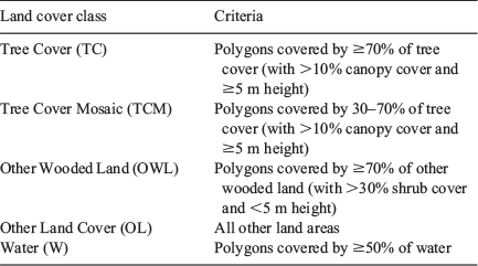
Land cover database was derived from a previous pan-tropical deforestation survey (Achard et al. 2014), with corrections performed from the use of pre-fire Landsat satellite imagery as described above (representing ~40% of the imagery). The satellite data pre-processing included radiometric calibration, de-hazing, spectral normalisation and cloud-masking (Bodart et al. 2011), followed by a multistage image segmentation to create spatially and spectrally consistent mapping units (polygons) with a minimum mapping unit of 5 ha (Raši et al. 2011, 2013). In each of the 10 km × 10 km sample site, objects (i.e. polygons) were classified into five land cover types (Table 1). Polygons which were considered to have trees at least 5 m tall and canopy cover percentage more than 10% by visual interpretation of the Landsat images were classified as Tree Cover. The Other Wooded Land included any woody vegetation less than 5 m in height and more than ~30% shrub coverage (Raši et al. 2011). The polygons were assigned into the land cover types based on the proportions of land cover types detected within the polygon (Table 1). The visual polygon assignment was conducted after automated pre-classification using a specially developed visual image interpretation tool (Simonetti et al. 2011).
|
The accuracy of the classification approach was extensively analysed by Achard et al. (2014), using an independent pan-tropical consistency analysis with 3567 systematic and 4282 change points (i.e. points were land cover change had been detected between two consecutive mappings), including 1185 systematic and 1663 change points in South America. The polygons over which the selected accuracy assessment points fell were carefully visually re-interpreted by independent experts using ancillary information when available (e.g. imagery from Google Earth considering the date of imagery). The overall agreement between the original and the reinterpreted results was 92.9% for the forest classes pan-tropically (94.5% for South America) and 85.5% for the forest change (85.1% for South America). In addition to this, Eva et al. (2012) also compared the land cover mapping results to the INPE interpretations for period 1990–2000 (INPE 2014) for random sample of 34 sample units and found very high correlation both for the forest area of year 1990 (r2 = 0.986) as well as for the deforestation of period 1990–2000 (r2 = 0.978). The re-interpretation of the ~40% of the imagery database with pre-fire satellite images is not expected to have affected the classification accuracy since it only affected a few polygons (i.e. polygons in which land cover had changed between the acquisition dates of the old and updated imagery database images) and was performed with the same methodology and interpreters.
Burned area mapping
The burned area mapping method used in this study was developed by Shimabukuro et al. (2014) and is fully described in Shimabukuro et al. (in press). The method followed closely the land cover mapping procedure described above, with identical data pre-processing steps and visual interpretation interface. In each of the sample site, objects were classified into burned and unburned areas from the Landsat imagery selected during the late dry season. An absolute minimum mapping unit (MMU) of 3 ha was used, with maximum of 5% of polygons smaller than 5 ha. Based on further analysis, burned areas smaller than the 3 ha and 5 ha MMUs were found to represent 0.007% and 0.026% of burned area in Mato Grosso respectively (Shimabukuro et al. in press). MODIS active fire detections (i.e. hotspots) overlaid on the Landsat scenes were used as supporting background information during the visual interpretation of burned area polygons for the 2005 and 2010 datasets. In case no hotspots were detected on the suspected area and burning could not be confirmed by pure visual analysis of the suspected burn scar, the area was considered as unburned.
In the paper fully presenting the burned area mapping methodology Shimabukuro et al. (in press) analysed the characteristics and accuracy of the method in detail by comparing 2010 burned area mapping results (also used in this study) to two other approaches: (i) a wall-to-wall mapping method developed by the Brazilian Institute for Space Research using Landsat-5 TM imagery and (ii) MODIS MCD64A1 burned area products of the University of Maryland. They found r2 = 0.91 and r2 = 0.85 correlations within the 77 samples in Mato Grosso between the 2010 burned area dataset used in this study and the two reference methods respectively. Furthermore, they showed that the method used in this study enabled inclusion of smaller burn scars and more detailed classification than the reference methods due to the higher spatial resolution or the visual interpretation enabled by the sampling approach. In addition to the already existing 2010 burned area mapping, in this study the same classification approach was applied to the 2005 and 2000 datasets by the same interpreters.
Land cover vs burned area analysis
The combination of medium resolution land cover and burned area information on state level analysis (albeit from a sample) provides the opportunity to analyse the association between land cover and burned area on an unprecedented level of detail. The burned area and land cover mapping results were overlaid for each of the study years (2000–2005–2010) to derive 1) the areas of different land cover types before the start of the fire season and the total burned area accumulated during the fire season and 2) the burned area distribution between different land cover types. The changes between the study years were subsequently analysed. Supported by earlier findings on the characteristics of forest fires in the Amazonian tropical forests (e.g. Cochrane 2003; Morton et al. 2013; Shimabukuro et al. 2014), all burning in the Tree Cover and Tree Cover Mosaic classes were considered to cause forest degradation.
All of the analyses were performed separately for the Amazon and Cerrado (including Pantanal) biomes. The Amazon biome dataset included 43 sample sites while the Cerrado dataset included 34 sample sites. The analyses were based both on direct comparison of the mapping results within the sample sites between the study years, as well as on comparison of biome wide estimates derived based on the sample. The biome wide estimates were derived by multiplying the average burned area in the sample sites with the total area of the biome (Amazon 48 Mha and Cerrado + Pantanal 42 Mha). Subsequently, standard error for this estimate was derived by dividing the standard deviation of the samples by the square root of the number of samples. In the 2010 Amazon biome burned area dataset one sample site alone contained 51% of all burned area and 69% of all burned area in the Tree Cover class. In order to reduce the standard error for the 2010 estimate and thereby enable more reliable inter-annual comparison between the study years, this single sample site was replaced by the average values of the remaining 42 sample sites. It has to be kept in mind, however, that this replacement reduces drastically the estimate of burned area for the Amazon biome for year 2010 (particularly for the Tree Cover class), consequently leading to a conservative estimate of 2010 burned areas.
Results
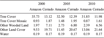
In order to provide general understanding on the land cover changes during the study period, we first summarise the land cover dataset without burned area information. Over the entire decade 2000–2010, the Amazon and Cerrado biomes lost 3.89 Mha and 1.13 Mha of Tree Cover respectively, corresponding to 10.9% and 8.7% of the original Tree Cover in 2000 respectively (Table 2). However, deforestation was unevenly distributed within the decade, with the large majority taking place during the first half of the decade. Considering forest area as the combination of Tree Cover area and half of the Tree Cover Mosaic (Eva et al. 2012; Achard et al. 2014), the net deforestation during the first half of the decade (2000–2005) in the Amazon biome was ~2.96 Mha (or 8.2% of the 2000 forest cover) but only ~0.96 Mha (or 2.9% of the 2005 forest cover) during the second half (2005–2010). These figures correspond to ~1.6% and ~0.6% yearly deforestation rates respectively, showing a remarkable decrease in the level of deforestation. In the Cerrado biome such drastic decrease cannot be detected, although the deforestation in the first half of the decade (0.69 Mha) is slightly higher than (0.57 Mha) in the second half.
|
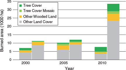
Unlike the deforestation rates, the extent of burned areas recorded in 2000, 2005 and 2010 do not show signs of decrease, most particularly not for the forest areas (Fig. 2). The total extent of burning in the Amazon biome does not show clear increase over the three study years with 7080 ha, 10 220 ha and 7680 ha of burned area recorded in the sample sites in 2000, 2005 and 2010 respectively. However, both the proportion and absolute extent of burned Tree Cover is clearly lower in 2000 and 2005 at 18.7% (1320 ha) and 6.2% (635 ha) respectively, as compared with the 35.8% (2750 ha) in 2010. Furthermore, it needs to be remembered that the 2010 burned area (particularly for the Tree Cover class) should be considered as a very conservative estimate due the removal of one sample site with an exceptional extent of burned area. With this site included the total burned area detected for the Amazon biome in Mato Grosso would be 15 240 ha, with 8650 ha (56.4%) burned tree cover. In the Cerrado the most striking feature of the burned area statistics (Fig. 2) is the vast extent of burned area in year 2010. There is no sign of dramatic changes between the study years in the distribution of burned area among the land cover types, with Other Land Cover clearly dominating in all of the years. Nevertheless, the large extent of burned area in 2010 means that in absolute terms all of the land cover types, including the Tree Cover class, experienced the largest extent of burned area among the study years in 2010.
|
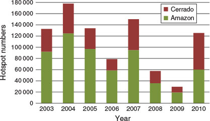
According to the number of active fires detected by MODIS sensors in 2005 and 2010, burning seasons in Mato Grosso in the two years are rather similar in terms of total fire activity in the state (Figs 3 and 4). Yet, a more detailed analysis of the fire distribution reveals some interesting differences between the two years. First, it can be seen that the fire season of 2010 in the Cerrado biome was clearly more severe than the fire season of 2005 (Fig. 3). This finding may largely explain the dramatic increase in total burned area in Cerrado in 2010. Second, the active fire statistics (Figs 3 and 4) also reveal that in the Amazon biome there are in fact clearly less fires detected in 2010 as compared with 2005 (~97 000 vs ~60 000). This further emphasises the significance of the large extent of burned area in the Tree Cover class in 2010 highlighted above. Even with a lower number of active fires detected, the area of burned forest is larger.
|
|
At the level of the entire Amazon biome in Mato Grosso State, the extent of burned Tree Cover in 2010 can be estimated to be at least 317 000 ha, remembering that this is a very conservative estimate due to the removed sample site. With the removed sample site included, the estimate of burned tree cover area in the Amazon part of Mato Grosso would be more than three times higher, at 990 700 ha, with standard error (s.e.) of 680 000 ha. In 2000 and 2005 merely ~150 000 ha and 70 000 ha of burned Tree Cover were detected respectively (Table 3). In all of the study years the standard error for the burned area estimate in the Tree Cover class is between 28% and 37% of the mean (without the removed plot). The total state-wide burned area was nearly double in 2010 as compared with 2005 (5.150 Mha vs 2.634 Mha) from 2005 to 2010. But as shown above, this increase was mainly due to the drastic increase in burning in the Cerrado, which experienced a severe fire season in 2010.

|
Discussion and conclusion
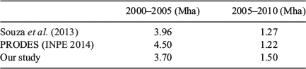
In this paper we have investigated the dynamics of land cover and burned area distribution in Mato Grosso State in the Brazilian Amazon in 2000, 2005 and 2010. Our results revealed a large extent of fire-induced forest degradation in 2010 in the Amazon biome of Mato Grosso State as compared with 2000 and 2005. In contrast, the annual rate of deforestation in the Amazon biome dropped from 1.6% year–1 to 0.6% year–1 from the first to the latter half of the decade. In respect to the decrease in deforestation in Mato Grosso our results agree well with earlier studies (Table 4).
|
In general level our results on the extent of fire-induced forest degradation agree with Morton et al. (2013) who highlighted in their regional MODIS based analysis the continuation of understorey forest fires in the latter part of the 2000s regardless of the falling deforestation rates. Other studies on forest degradation mapping have often suffered from limited availability of satellite data which may have affected particularly the detection of fire-induced forest degradation. We believe that in order to monitor fire-induced degradation with medium resolution data, it is essential to use a specifically chosen set of late fire season images for burned area mapping and a set of pre-fire season images for the land cover analysis. For example, the degradation estimate for year 2010 at 162 500 ha from Souza et al. (2013), including both selective logging and fire-induced degradation, was derived from Landsat images acquired before July 2010, at which point the fire season of 2010 was only starting. Similarly, Shimabukuro et al. (2014) found that a ‘standard’ set of cloud free Landsat images used for deforestation monitoring resulted in only 160 000 ha burned area estimate for the entire Mato Grosso State in 2010, while a set of late fire season images resulted in a ~5.5 Mha burned area estimate. These examples, together with the results obtained in this study, suggest that fire-induced degradation in Amazonian forests may have been generally underestimated.
In this study we have considered all burned forest areas as degraded forest. Slashing of forest for land conversion typically takes place before the dry season in Mato Grosso, followed by drying period and finally burning in the late dry season. Therefore, it is unlikely that the areas classified as forest in our early dry season images would have been deliberately burned for land conversion purposes. It is also safe to assume that fires in the humid tropical Amazon forests, which are typically understorey fires, cause degradation since they are extremely rare in natural conditions and the forests are not adapted to them (Cochrane 2003). However, Morton et al. (2013) found that only 3.8% of understorey burned forest areas in the Amazon biome were deforested within five years of the fire, indicating that Amazonian forest fires do not usually lead to deforestation of the area. Therefore we believe the results obtained in this study are a good indication of the extent of fire-induced degradation in the Amazon forests. It has to be remembered, however, that the Cerrado seasonal forests are more adapted to fire (Pivello 2011; Beuchle et al. 2015). Without more detailed information on the fire history of burned areas, we cannot tell whether or not the forest fires detected in the Cerrado caused degradation. Even in dry tropical forests fires may cause forest degradation if the frequency or intensity of fires becomes abnormally high (Dwyer et al. 2000).
While interpreting the conclusions of this study, it needs to be remembered that the extent of fire activity varies dramatically in the humid tropical regions between years (Fig. 4), depending on climatic conditions (see e.g. Field et al. 2009). Consequently, regional level coarse resolution approaches have indicated that also the extent of fire-induced forest degradation in the Amazon varies considerably between years (Morton et al. 2013). The results of this study should therefore not be taken as a direct indication of a general increase in yearly forest fire extent in the Amazon biome of Mato Grosso. Further studies are needed to create a better understanding on the trends of fire-induced forest degradation in Mato Grosso and in the entire Amazon region. This does not only depend on the trends of fire susceptibility of the forests, but also on the trends of climatic conditions, anthropogenic activities etc.
The results of this study are based on a systematic sampling scheme originally designed for pan-tropical deforestation assessments (Achard et al. 2014). The suitability of the approach for burned area estimation in state level was demonstrated by Shimabukuro et al. (in press), who also discussed the advantages (e.g. enabling rapid and detailed visual interpretation for large interest areas) and disadvantages (e.g. limitations of accuracy with small sample sizes) of the sampling approach. In the case of our study, the small number of sample sites resulted in rather high standard errors of the estimates, which in turn restricted our possibilities to perform more detailed analyses on the differences between the study years. Therefore, we were forced to concentrate merely on the major patterns of the burning seasons and we can only take our results as indications of potential changes taking place in the fire susceptibility of the forests in the region. Although we believe the current sampling intensity was sufficient to provide reliable estimates on the broad patterns of the burning seasons, a higher sampling intensity or different sampling design (e.g. stratified sampling) would certainly allow more detailed analysis on the characteristics and effects of a burning season.
In any case, the large extent of burning in the Tree Cover class in 2010 revealed by the results of this study is potentially a startling discovery and warrants further investigation. It needs to be remembered that the MODIS active fire analysis revealed 2010 to be less severe fire year than 2005 in the Amazon biome. Therefore, the large extent of fire-induced forest degradation in 2010 may be a result of the degrading effects of the ever spreading and intensifying anthropogenic activities in the Amazon forests causing increased fire susceptibility (Cochrane 2003; Matricardi et al. 2010). This may be leading to an increasing extent of burned forest in the Amazon causing subsequent degradation with potentially serious consequences (Brando et al. 2014). Regardless of the reduction of deforestation, recent analysis has revealed continuing expansion of agricultural areas and associated land use changes (Macedo et al. 2012), potentially increasing pressure on forest areas. It has been shown that reduction of deforestation rates does not necessarily lead to reduction in forest fire activity in the Amazonia (Aragão and Shimabukuro 2010; Morton et al. 2013).
The findings of this study may indicate that the forests of Mato Grosso could be becoming increasingly vulnerable to fire. Climatic and ecological conditions throughout the Brazilian Amazon enable similar development, putting millions of square kilometres of humid tropical forest potentially in danger of increased fire activity and subsequent degradation over the next decades. This would not only jeopardise the biodiversity in Amazonian forests, but it could have a fundamental effect on the amount of carbon stored in the region. Extensive human induced fire activity in the Amazonian forests could compromise the efficacy of emission reduction policies, such as activities related to Reducing Emissions from Deforestation and Degradation (REDD+) in framework of UNFCCC (United Nations Framework Convention on Climate Change) (Aragão and Shimabukuro 2010; Barlow et al. 2012). This emphasise the importance of actions to prevent forest fires to be taken most urgently and advocate inclusion of forest fire mapping into carbon accounting initiatives.
References
Achard F, Beuchle R, Mayaux P, Stibig H-J, Bodart C, Brink A, Carboni S, Desclée B, Donnay F, Eva HD, Lupi A, Raši R, Seliger R, Simonetti D (2014) Determination of tropical deforestation rates and related carbon losses from 1990 to 2010. Global Change Biology 20, 2540–2554.| Determination of tropical deforestation rates and related carbon losses from 1990 to 2010.Crossref | GoogleScholarGoogle Scholar | 24753029PubMed |
Aragão LEOC, Shimabukuro YE (2010) The incidence of fire in Amazonian forests with implications for REDD. Science 328, 1275–1278.
| The incidence of fire in Amazonian forests with implications for REDD.Crossref | GoogleScholarGoogle Scholar |
Asner GP, Knapp DE, Broadbent EN, Oliveira PJC, Keller M, Silva JN (2005) Selective logging in the Brazilian Amazon. Science 310, 480–482.
| Selective logging in the Brazilian Amazon.Crossref | GoogleScholarGoogle Scholar | 1:CAS:528:DC%2BD2MXhtFahtrrI&md5=358df69917becb03c8edf507bbe292d6CAS | 16239474PubMed |
Asner GP, Broadbent EN, Oliveira PJC, Keller M, Knapp DE, Silva JNM (2006) Condition and fate of logged forests in the Brazilian Amazon. Proceedings of the National Academy of Sciences of the United States of America 103, 12 947–12 950.
| Condition and fate of logged forests in the Brazilian Amazon.Crossref | GoogleScholarGoogle Scholar | 1:CAS:528:DC%2BD28XptVyqtL0%3D&md5=e1376b08bc58b7a0f2368f85f7214552CAS |
Barlow J, Parry L, Gardner TA, Ferreira J, Aragão LEOC, Carmenta R, Berenguer E, Vieira ICG, Souza C, Cochrane MA (2012) The critical importance of considering fire in REDD+ programs. Biological Conservation 154, 1–8.
| The critical importance of considering fire in REDD+ programs.Crossref | GoogleScholarGoogle Scholar |
Berenguer E, Ferreira J, Gardner TA, Aragão LEOC, Camargo PB, Cerri CE, Durigan M, Oliveira RC, Vieira ICG, Barlow J (2014) A large-scale field assessment of carbon stocks in human-modified tropical forests. Global Change Biology 20, 3713–3726.
| A large-scale field assessment of carbon stocks in human-modified tropical forests.Crossref | GoogleScholarGoogle Scholar | 24865818PubMed |
Beuchle R, Eva HD, Stibig H-J, Bodart C, Brink A, Mayaux P, Johansson D, Achard F, Belward A (2011) A satellite data set for tropical forest change assessment. International Journal of Remote Sensing 32, 7009–7031.
| A satellite data set for tropical forest change assessment.Crossref | GoogleScholarGoogle Scholar |
Beuchle R, Grecchi RC, Shimabukuro YE, Seliger R, Eva HD, Sano E, Achard F (2015) Land cover changes in the Brazilian Cerrado and Caatinga biomes from 1990 to 2010 based on a systematic remote sensing sampling approach. Applied Geography (Sevenoaks, England) 58, 116–127.
| Land cover changes in the Brazilian Cerrado and Caatinga biomes from 1990 to 2010 based on a systematic remote sensing sampling approach.Crossref | GoogleScholarGoogle Scholar |
Bodart C, Eva H, Beuchle R, Raši R, Simonetti D, Stibig H-J, Brink A, Lindquist E, Achard F (2011) Pre-processing of a sample of multi-scene and multi-date Landsat imagery used to monitor forest cover changes over the tropics. ISPRS Journal of Photogrammetry and Remote Sensing 66, 555–563.
| Pre-processing of a sample of multi-scene and multi-date Landsat imagery used to monitor forest cover changes over the tropics.Crossref | GoogleScholarGoogle Scholar |
Brando PM, Balch JK, Nepstad DC, Morton DC, Putz FE, Coe MT, Silverio D, Macedo MN, Davidson EA, Nobrega CC, Alencar A, Soares-Filho BS (2014) Abrupt increases in Amazonian tree mortality due to drought-fire interactions. Proceedings of the National Academy of Sciences of the United States of America 111, 6347–6352.
| Abrupt increases in Amazonian tree mortality due to drought-fire interactions.Crossref | GoogleScholarGoogle Scholar | 1:CAS:528:DC%2BC2cXmtlWru78%3D&md5=37f192b65ea22b3f10c9b60dab444cd5CAS | 24733937PubMed |
Cochrane MA (2003) Fire science for rainforests. Nature 421, 913–919.
| Fire science for rainforests.Crossref | GoogleScholarGoogle Scholar | 1:CAS:528:DC%2BD3sXhsVKgtb4%3D&md5=a35c1ebbbfd942125445fa0371405aa8CAS | 12606992PubMed |
Cochrane MA, Laurance WF (2002) Fire as a large-scale edge effect in Amazonian forests. Journal of Tropical Ecology 18, 311–325.
| Fire as a large-scale edge effect in Amazonian forests.Crossref | GoogleScholarGoogle Scholar |
Cochrane MA, Alencar A, Schulze MD, Souza C, Nepstad D, Lefebvre P, Davidson E (1999) Positive feedbacks in the fire dynamics of closed canopy tropical forests. Science 284, 1832–1835.
| Positive feedbacks in the fire dynamics of closed canopy tropical forests.Crossref | GoogleScholarGoogle Scholar | 1:CAS:528:DyaK1MXjvFSqsLw%3D&md5=22017dedd868bbb087bd9d7b3236c16bCAS | 10364555PubMed |
Dwyer E, Pereira JMC, Grégoire JM, Da Camara CC (2000) Characterization of the spatio-temporal patterns of global fire activity using satellite imagery for the period April 1992 to March 1993. Journal of Biogeography 27, 57–69.
| Characterization of the spatio-temporal patterns of global fire activity using satellite imagery for the period April 1992 to March 1993.Crossref | GoogleScholarGoogle Scholar |
Eva HD, Carboni S, Achard F, Stach N, Durieux L, Faure J-F, Mollicone D (2010) Monitoring forest areas from continental to territorial levels using a sample of medium spatial resolution satellite imagery. ISPRS Journal of Photogrammetry and Remote Sensing 65, 191–197.
| Monitoring forest areas from continental to territorial levels using a sample of medium spatial resolution satellite imagery.Crossref | GoogleScholarGoogle Scholar |
Eva HD, Achard F, Beuchle R, de Miranda E, Carboni S, Seliger R, Vollmar M, Holler WA, Oshiro OT, Barrena Arroyo V, Gallego J (2012) Forest cover changes in tropical South and Central America from 1990 to 2005 and related carbon emissions and removals. Remote Sensing 4, 1369–1391.
| Forest cover changes in tropical South and Central America from 1990 to 2005 and related carbon emissions and removals.Crossref | GoogleScholarGoogle Scholar |
Field RD, van der Werf GR, Shen SSP (2009) Human amplification of drought-induced biomass burning in Indonesia since 1960. Nature Geoscience 2, 185–188.
| Human amplification of drought-induced biomass burning in Indonesia since 1960.Crossref | GoogleScholarGoogle Scholar | 1:CAS:528:DC%2BD1MXisVCgt74%3D&md5=829ca3602d740f5735c84d60ecbe3ca3CAS |
FIRMS (2014) ‘Fire information for resource management system (FIRMS).’ Available at https://earthdata.nasa.gov/data/near-real-time-data/firms/active-fire-data [Verified 27 August 2014]
Giglio L, Descloitres J, Justice CO, Kaufman YJ (2003) An enhanced contextual fire detection algorithm for MODIS. Remote Sensing of Environment 87, 273–282.
| An enhanced contextual fire detection algorithm for MODIS.Crossref | GoogleScholarGoogle Scholar |
Giglio L, Loboda T, Roy DP, Quayle B, Justice CO (2009) An active-fire based burned area mapping algorithm for the MODIS sensor. Remote Sensing of Environment 113, 408–420.
| An active-fire based burned area mapping algorithm for the MODIS sensor.Crossref | GoogleScholarGoogle Scholar |
Hosonuma N, Herold M, De Sy V, De Fries RS, Brockhaus M, Verchot L, Angelsen A, Romijn E (2012) An assessment of deforestation and forest degradation drivers in developing countries. Environmental Research Letters 7, 044009
| An assessment of deforestation and forest degradation drivers in developing countries.Crossref | GoogleScholarGoogle Scholar |
IBGE-MMA (2004) ‘Mapas murais – Mapa de biomas do Brasil.’ Instituto Brasileiro de Geografia e Estatística (IBGE) and Ministério do Meio Ambiente (MMA). Available at http://www.ibge.gov.br/home/geociencias/default_prod.shtm [Verified 1 January 2015]
INPE (2014) ‘PRODES, Monitoramento da floresta Amazônica por satélite.’ Instituto Nacional de Pesquisas Espaciais. Available at http://www.obt.inpe.br/prodes/index.php [Verified 1 December 2014]
Laris PS (2005) Spatiotemporal problems with detecting and mapping mosaic fire regimes with coarse-resolution satellite data in savanna environments. Remote Sensing of Environment 99, 412–424.
| Spatiotemporal problems with detecting and mapping mosaic fire regimes with coarse-resolution satellite data in savanna environments.Crossref | GoogleScholarGoogle Scholar |
Macedo MN, DeFries RS, Morton DC, Stickler CM, Galford GL, Shimabukuro YE (2012) Decoupling of deforestation and soy production in the southern Amazon during the late 2000s. Proceedings of the National Academy of Sciences of the United States of America 109, 1341–1346.
| Decoupling of deforestation and soy production in the southern Amazon during the late 2000s. Crossref | GoogleScholarGoogle Scholar | 1:CAS:528:DC%2BC38XislWksbc%3D&md5=ec3341ee2aac9155d68c07d420c5e553CAS | 22232692PubMed |
Matricardi EAT, Skole DL, Pedlowski MA, Chomentowski W, Fernandes LC (2010) Assessment of tropical forest degradation by selective logging and fire using Landsat imagery. Remote Sensing of Environment 114, 1117–1129.
| Assessment of tropical forest degradation by selective logging and fire using Landsat imagery.Crossref | GoogleScholarGoogle Scholar |
Miettinen J, Liew SC (2009) Burn scar patterns and their effect on regional burnt area mapping in insular Southeast Asia. International Journal of Wildland Fire 18, 837–847.
| Burn scar patterns and their effect on regional burnt area mapping in insular Southeast Asia.Crossref | GoogleScholarGoogle Scholar |
Miettinen J, Hyer E, Chia AS, Kwoh LK, Liew SC (2013) Detection of vegetation fires and burnt areas by remote sensing in insular Southeast Asian conditions: current status of knowledge and future challenges. International Journal of Remote Sensing 34, 4344–4366.
| Detection of vegetation fires and burnt areas by remote sensing in insular Southeast Asian conditions: current status of knowledge and future challenges.Crossref | GoogleScholarGoogle Scholar |
Morton DC, DeFries RS, Nagol J, Souza CM, Kasischke ES, Hurtt GC, Dubayah R (2011) Mapping canopy damage from understory fires in Amazon forests using annual time series of Landsat and MODIS data. Remote Sensing of Environment 115, 1706–1720.
| Mapping canopy damage from understory fires in Amazon forests using annual time series of Landsat and MODIS data.Crossref | GoogleScholarGoogle Scholar |
Morton DC, Page YL, DeFries R, Collatz GJ, Hurtt GC (2013) Understorey fire frequency and the fate of burned forests in southern Amazonia. Philosophical Transactions of the Royal Society of London. Series B, Biological Sciences 368, 20120163
| Understorey fire frequency and the fate of burned forests in southern Amazonia.Crossref | GoogleScholarGoogle Scholar | 1:STN:280:DC%2BC3srns1artg%3D%3D&md5=456017feedd55c5cf1defa375dd07fc0CAS | 23610169PubMed |
Numata I, Cochrane MA, Roberts DA, Soares JV, Souza CM, Sales MH (2010) Biomass collapse and carbon emissions from forest fragmentation in the Brazilian Amazon. Journal of Geophysical Research 115, G03027
| Biomass collapse and carbon emissions from forest fragmentation in the Brazilian Amazon.Crossref | GoogleScholarGoogle Scholar |
Pivello VR (2011) The use of fire in the Cerrado and Amazonian rainforests of Brazil: past and present. Fire Ecology 7, 24–39.
| The use of fire in the Cerrado and Amazonian rainforests of Brazil: past and present.Crossref | GoogleScholarGoogle Scholar |
Tahir Qadri S (Ed.) (2001) ‘Fire, smoke and haze: the ASEAN response strategy.’ (Asian Development Bank: Manila)
Raši R, Bodart C, Stibig H-J, Eva H, Beuchle R, Carboni S, Simonetti D, Achard F (2011) An automated approach for segmenting and classifying a large sample of multi-date Landsat imagery for pan-tropical forest monitoring. Remote Sensing of Environment 115, 3659–3669.
| An automated approach for segmenting and classifying a large sample of multi-date Landsat imagery for pan-tropical forest monitoring.Crossref | GoogleScholarGoogle Scholar |
Raši R, Beuchle R, Bodart C, Vollmar M, Seliger R, Achard F (2013) Automatic updating of an object-based tropical forest cover classification and change assessment. IEEE Journal of Selected Topics in Applied Earth Observations and Remote Sensing 6, 66–73.
| Automatic updating of an object-based tropical forest cover classification and change assessment.Crossref | GoogleScholarGoogle Scholar |
Schroeder W, Prins E, Giglio L, Csiszar I, Schmidt C, Morisette J, Morton D (2008) Validation of GOES and MODIS active fire detection products using ASTER and ETM+_data. Remote Sensing of Environment 112, 2711–2726.
| Validation of GOES and MODIS active fire detection products using ASTER and ETM+_data.Crossref | GoogleScholarGoogle Scholar |
Setzer AW, Pereira MC (1991) Amazonia biomass burnings in 1987 and an estimate of their tropospheric emissions. Ambio 20, 19–22.
Shimabukuro YE, Beuchle R, Grecchi RC, Simonetti D, Achard F (2014) Assessment of burned areas in Mato Grosso State, Brazil, from a systematic sample of medium resolution satellite imagery. In ‘Proc. of the IGARSS 2014, IEEE International Geoscience and Remote Sensing Symposium’, 13–18 July 2014, Québec, Canada. (IEEE: New Jersey)
Shimabukuro YE, Miettinen J, Beuchle R, Grecchi RC, Simonetti D, Achard F Estimating burned area in Mato Grosso, Brazilian Amazon, using an object-based classification method on a systematic sample of medium resolution satellite images. IEEE Journal of Selected Topics in Applied Earth Observations and Remote Sensing
| Estimating burned area in Mato Grosso, Brazilian Amazon, using an object-based classification method on a systematic sample of medium resolution satellite images.Crossref | GoogleScholarGoogle Scholar |
Simonetti D, Beuchle R, Eva H (2011) ‘User manual for the JRC land cover/use change validation tool.’ (European Commission Joint Research Centre: Ispra)
Simula M (2009) ‘Towards defining forest degradation: comparing analysis of existing definitions. Forest Resources Assessment Working Paper 154’ (Food and Agriculture Organization of the United Nations: Rome)
Souza CM, Siqueira JV, Sales MH, Fonseca AV, Ribeiro JG, Numata I, Cochrane MA, Barber CP, Roberts DA, Barlow J (2013) Ten-year landsat classification of deforestation and forest degradation in the Brazilian Amazon. Remote Sensing 5, 5493–5513.
| Ten-year landsat classification of deforestation and forest degradation in the Brazilian Amazon.Crossref | GoogleScholarGoogle Scholar |
Tansey K, Grégoire JM, Defourny P, Leigh R, Pekel J-F, van Bogaert E, Bartholomé E (2008) A new, global, multi-annual (2000–2007) burned area product at 1 km resolution. Geophysical Research Letters 35, L01401
| A new, global, multi-annual (2000–2007) burned area product at 1 km resolution.Crossref | GoogleScholarGoogle Scholar |
Tucker CJ, Townshend JRG (2000) Strategies for monitoring tropical deforestation using satellite data. International Journal of Remote Sensing 21, 1461–1471.
| Strategies for monitoring tropical deforestation using satellite data.Crossref | GoogleScholarGoogle Scholar |
van der Werf GR, Randerson JT, Giglio L, Collatz GJ, Mu M, Kasibhatla PS, Morton DC, DeFries RS, Jin Y, van Leeuwen TT (2010) Global fire emissions and the contribution of deforestation, savanna, forest, agricultural, and peat fires (1997–2009). Atmospheric Chemistry and Physics 10, 11 707–11 735.
| Global fire emissions and the contribution of deforestation, savanna, forest, agricultural, and peat fires (1997–2009).Crossref | GoogleScholarGoogle Scholar | 1:CAS:528:DC%2BC3MXmvFemsb0%3D&md5=e4141b6bc1ec84d7e5ca7cc2873c78beCAS |