

Geographic patterns and correlates of the decline of granivorous birds in northern Australia
Donald C. Franklin A G , Peter J. Whitehead A B , Guy Pardon A C , Janet Matthews A D , Philip McMahon A E and Daniel McIntyre A FA School for Environmental Research, Charles Darwin University, Darwin, NT 0909, Australia.
B Current address: Department of Infrastructure Planning and Environment, PO Box 496, Palmerston, NT 0831, Australia.
C Current address: 5/56 Chapman Road, Rapid Creek, NT 0810, Australia.
D Current address: 84 Carnoustie Circuit, Northlakes, NT 0812, Australia.
E Current address: PO Box 390, Howard Springs, NT 0835, Australia.
F Current address: Department of Spatial Sciences, Curtin University of Technology, GPO Box U1987, Perth, WA 6845, Australia.
G Corresponding author: Email: don.franklin@cdu.edu.au
Wildlife Research 32(5) 399-408 https://doi.org/10.1071/WR05052
Submitted: 27 May 2005 Accepted: 28 June 2005 Published: 8 August 2005
Abstract
A geographic index of the decline in the distribution and abundance of granivorous birds in tropical northern Australia shows that declines are greatest in Queensland and especially in the south-eastern tropics and in inland areas, and lowest in the north Kimberley and east Arnhem districts. In this paper, we use generalised linear models to investigate interrelationships among an index of decline in 1° by 1° cells and measures of grazing intensity and contemporary patterns of burning, together with the environmental variables of rainfall, vegetation and topographic patterning in the landscape. Grazing intensity was the single strongest human effect but strong correlations between grazing intensity and other human influences suggest that these may have been subsumed within the grazing intensity measure. Impacts of grazing may be worse where pastoral settlement occurred earlier. Topographic variation appeared to be a mitigating effect, suggesting a role for ‘topographic refuges’ from human activities. Relationships among granivore declines, grazing and rainfall are difficult to disentangle using inferential statistics, but a consistent effect is that declines are more severe in areas with greater year-to-year variation in rainfall. We do not suggest that our analyses are conclusive. However, they do support the proposition that better understanding of the causes of decline at finer spatial scales will emerge most strongly in studies that link habitat quality with granivore demography at inland sites of highly variable year-to-year rainfall and with strongly contrasting grazing histories.
Introduction
The species-rich granivorous bird assemblages of the northern Australian savannas have undergone substantial adverse change since European settlement. Approximately one-third of all granivorous bird taxa have declined (Franklin 1999), three taxa are endangered and one is extinct (Garnett and Crowley 2000). The declines are particularly perplexing and disturbing as the northern Australian savannas contain perhaps the most extensive intact tract of natural vegetation in Australia and, indeed, comprise one of the few great remaining ‘natural’ regions of the world. In their taxonomic and geographic pervasiveness, and occurrence under a regime of low-intensity human settlement, the declines parallel those of the mammals of arid Australia (Morton 1990; Recher and Lim 1990).
European pastoral occupation of these savannas occurred later than in most other parts of Australia (Holmes 1966; Ash et al. 1997) and, by corollary, Aboriginal occupation and the pre-European style of land management remained in place here for longer than elsewhere in Australia. Cattle grazing remains the primary European land-use, but stocking densities are, for the most part, exceptionally low, frequently less than 2 cattle km–2 (DNM 1982). The rabbit (Oryctolagus cuniculus) and fox (Vulpes vulpes), introduced species thought to have caused gross environmental degradation elsewhere in Australia (Burbidge and McKenzie 1989), are largely absent (DEST 1996). Land-clearing for more intensive agricultural development is a recent phenomenon, largely post-dating the decline of granivorous birds, and is extensive only in the south-east of these savannas (Graetz et al. 1995; DEST 1996).
Several studies have concentrated on identifying the agents of change for individual species at one or a few study sites (e.g. Tidemann 1996; Crowley and Garnett 1998, 1999, 2001; Fraser 2000; Dostine et al. 2001). An early emphasis on parasite infection (Tidemann et al. 1992) has now been replaced by a focus on the effects of pastoralism and changes to fire regimes on the availability of food resources and the structure of vegetation. Pastoralism and fire regimes appear to be the only causal agents of change related to European settlement sufficiently pervasive to explain the phenomenon. This emphasis reflects wider concerns about ecological processes and change to them in the northern Australian savannas (Ash et al. 1997; Crowley and Garnett 1998; Woinarski 1999).
Our aim in this paper is to provide perspective on the process of change at a spatial scale much larger and complementary to that of field studies, in order to focus further research into the problem. We first describe spatial patterns of change to the granivorous bird assemblage across the northern Australian landscape through an index of decline, which we derive from an extensive compilation of historic and recent records of these birds. Our index of decline is intended solely as an exploratory measure of the geographic distribution of the relative intensity of the biodiversity problem and does not in itself prove that a decline has occurred in any given area. Statistically robust demonstrations of decline of individual species are given in Franklin (1999).
We then explore correlates of this geographic pattern relating to pastoralism, fire and environmental effects known or speculated to interact with pastoralism and fire, using generalised linear modelling and the Akaike Information Criterion. In particular, we examine the following hypotheses:
-
Declines are expected to be more severe in areas where grazing intensity is higher and pastoralism has been established longer (Crowley and Garnett 1998; Whitehead 2000; Fisher 2003; Sharp and Whittaker 2003). In particular, grazing demonstrably affects grass composition, productivity and the seed resources it yields (e.g. Walker et al. 1997; Crowley and Garnett 2001; Ludwig et al. 2001).
-
Declines are expected to be related to fire regimes, as these vary markedly across the northern Australian landscape and have changed considerably in both frequency and timing since European settlement (Braithwaite 1991; Crowley and Garnett 2000; Russell-Smith et al. 2003a). The general trend has been for decreased frequency in pastoral areas and increased frequency in the higher-rainfall non-pastoral areas of the far north. These changes have important implications for biodiversity (Williams et al. 2002; Andersen et al. 2005). In particular, fire regimes demonstrably affect grass composition, productivity and the seed resources it yields (e.g. Mott and Andrew 1985; Lonsdale et al. 1998; Crowley and Garnett 1999; Russell-Smith et al. 2003b). However, the relationship between the direction of change to fire frequency and adverse effects of granivorous birds at the landscape scale is unclear.
-
Declines are expected to be more severe in areas of lower annual rainfall that is variable from year to year and strongly seasonal because these conditions will exacerbate the effects of grazing (Whitehead et al. 2001; Woinarski and Catterall 2004).
-
Declines will be ameliorated in regions of greater topographic and vegetation diversity because parts of the landscape may have been protected from the effects of grazing and/or fire (Gill et al. 2000; Yates and Russell-Smith 2003), or because heterogeneity increases foraging options (Woinarski 1999).
Methods
Study species
The primary granivore avifauna of northern Australia includes a species-rich suite of quail (Phasianidae), button-quail (Turnicidae), pigeons and doves (Columbidae), parrots and cockatoos (Psittaciformes) and finches (Passeridae) (Blakers et al. 1984), many of which are prominent components of the terrestrial avifauna. Compared with other areas of the Australian landmass, the savannas of northern Australia feature a prominence of ground-foraging granivores, and of finches and pigeons in particular, and relatively few tree-foraging species (Franklin et al. 2000). Our analysis focuses on the ground and arboreal species and we exclude wetland granivores such as the magpie goose (Anseranas semipalmata).
Study area
The tropical savanna region of northern Australia extends from the east coast of Queensland north of ~23°S, westward 3000 km to Western Australia, and comprises ~1.7 million km2. Climatically, the region is characterised by high temperatures throughout the year and highly seasonal rainfall, with most rain falling between November and April inclusive. Mean annual rainfall varies from 300 to 400 mm on the arid inland and western fringe to 2000 mm in the far north and north-east. Savanna vegetation comprises grassy woodlands usually dominated by Eucalyptus, Corymbia or Acacia trees, and grasslands, with small pockets of rainforest, riparian and eucalypt open forest, mangroves and heath interspersed. Ecological overviews of the area have been presented by Mott et al. (1985), Ridpath and Corbett (1985), Haynes et al. (1991) and Ash et al. (1997).
The Australian tropical savannas are thought to have existed for ~15 million years, notwithstanding considerable climatic fluctuations since then (Pole and Bowman 1996; Bowman 2002). Aboriginal people colonised the area extensively, beginning at least 40 000 years ago (Jones and Bowler 1980; Roberts et al. 1994). European pastoral settlement began in the 1850s and was largely complete by 1900 (Holmes 1966; Ash et al. 1997). Pastoralism is the principal land-use, with ~80% of the study area currently under pastoral lease. Most pastures are unimproved and comprise native grass and herbaceous species. Stock are mostly cattle, with highest stocking rates and more sheep in the south-east of the study area.
For the purpose of this study, northern Australia is defined as those 1° cells of latitude and longitude (n = 173) whose land area falls substantially within the 19 bioregions defined by Thackway and Cresswell (1995) north of 23°S that are dominated by tropical savanna (see Results).
The record of granivorous birds
A database of records of quail-like birds, cockatoos, finches and selected (i.e. granivorous) parrots and pigeons (see Franklin 1999) was compiled for the study area from the Birds Australia field and historical atlases (Blakers et al. 1984), the Northern Territory Fauna Database of the Parks and Wildlife Commission, and by perusal of numerous journals (listed in Franklin 1999) and historical sources (a list of bibliographic sources of historic material is provided by Franklin 1999). Any report of a species is a ‘record’. For each record, the species, year, location and source were noted. Records were attributed to cells comprising 1° of latitude and longitude, and vetted to avoid duplication.
Records were attributed to either the historic or recent period, defined as prior to or since 1 January 1977, respectively, there being 6261 historic records and 38 704 recent records. The cut-off date is arbitrary but informative (Franklin 1999). It is a practical response to the abundance of records for the period 1977–81 (Blakers et al. 1984), which provides a benchmark for the recent distribution and abundance of the Australian avifauna.
The index of decline
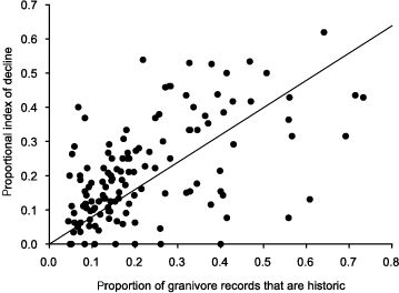
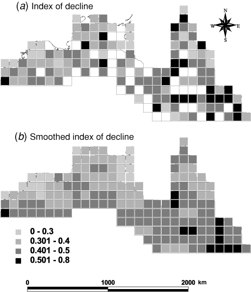
For each of the 173 1° cells, we first calculated a proportional index of decline (PIOD) as the proportion of species recorded historically that were not recorded recently. As described and explained in the following sub-section, we then corrected PIOD for the relative distribution of survey effort between the ‘historic’ and ‘recent’ periods in that cell, yielding the index of decline (IOD). The IOD is our key measure of the relative intensity of the biodiversity problem and the response variable for subsequent analysis of environmental correlates. For illustration, we also calculated a smoothed index of decline (SIOD), in which 1°-cell values of IOD were replaced with the weighted mean of values from a window of nine cells (maximum, subject to availability), with the initial (central) cell weighted 3×, adjacent cells weighted 2× and diagonal cells weighted 1×.
The PIOD is likely to be biased by differences between cells in the relative distribution of survey effort between the historic and recent periods. As there is no direct measure of survey effort, we utilised the size of the pool of records as a proxy for it, and the proportion of granivore records (PGR) that were historic as a relative measure. We believe this is reasonable because the dataset is dominated by common species, many of which have not undergone major changes in abundance, and there has been a compensatory pattern in which a large number of generally less frequent species has been reported less frequently but a few species that were already common have become more so (Franklin 1999).
A graph of PIOD against PGR identified a number of marked outliers that were identified as having 12 or fewer historic records. We therefore excluded all cells with 12 or fewer historic or recent records, 43 in total, whether they were outliers or not. For the remaining 130 cells, PIOD was positively correlated with the proportion of granivore records that were historic (PGR), with 30.7% of the variance explained (PIOD = 0.51PGR + 0.098, F1,128 = 56.7, P < 0.001). A more logical model, given that PIOD cannot be positive when PGR = 0, is obtained by forcing the intercept through the origin (PIOD = 0.80PGR); this is the relationship illustrated in Fig. 1. The IOD was calculated as the residuals from the latter regression increased by a constant, namely
|
∣ the largest negative residual ∣ + 0.00001.
The latter step was taken for simplicity of interpretation and to avoid the misleading implication that the transition from positive to negative values indicates a transition from a declining to an increasing richness in the granivorous avifauna.
The presence of spatial pattern in IOD was examined using a one-tailed Moran’s I test for positive autocorrelation with adjacent cells (Sokal and Oden 1978).
Analysis of environmental correlates
Environmental data were obtained from a variety of sources (Table 1). All were summarised for the land area of each 1° cell. The statistical distribution of each variable across cells was examined and appropriate transformations applied (Table 1). The dependant variable, IOD, was close to normally distributed and so was not transformed. Examination of scatter plots for each environmental variable against the IOD did not suggest any non-linear relationships.

|
The relationship between environmental variables and the IOD was examined using generalised linear models in the program Statistica (StatSoft 1999). The fit of models was compared using the Akaike information criterion (AIC) with the correction AICC (Burnham and Anderson 1998) applied manually. The AIC is an information-theoretic alternative to significance testing, particularly preferable in observational studies. AIC scores are relative rather than absolute and are used to rank and compare the usefulness of alternatives, lower scores indicating a more parsimonious model. Provided the sample of response variables remains constant, any explanatory models may be compared using AIC. As a rule of thumb, Burnham and Anderson (1998) recommend that models whose AIC scores differ (Δi) by less than ~2.0 should be considered potentially viable alternatives, that no one model should necessarily be accepted over all others, and that perceptions of biological/ecological processes should be fundamental drivers of model choice.
We adopted a multistep procedure to the analysis of our data, each step being an attempt to improve the fit of models to the IOD while narrowing the number of effects under consideration. Initial models were run independently with grazing and burning variables to identify the best combination for each. Each was then independently run with rainfall variables, with vegetation and topographic variables, and then with the selected combination of rainfall, vegetation and topographic variables. Finally, the best subset of variables from each of the grazing and burning subsets was combined into a final analysis. Our aim in using this multistep procedure was three-fold: (1) to gain maximum insight into both grazing and fire correlates separately because these two key anthropogenic effects are strongly correlated, (2) as an appropriate exploratory compromise between data-dredging and a rigid hypothesis-driven structure, and (3) to accommodate software constraints in dealing with so many variables and interactions.
At each step, we allowed only second-order interactions and only those between human effects or between a human effect and an environmental effect; we admitted only models in which variables occurring in interactions were also represented as main effects; and we considered only models in which the relevant grazing and/or burning variable appeared.
Results
Index of decline
There was significant spatial autocorrelation in the IOD (Fig. 2a) (Moran’s I = 0.237, n = 130, Z = 3.26, P(1–t) < 0.001), justifying the use of the SIOD (Fig. 2b). These indices suggest that decline has been most severe in the eastern (Queensland generally and especially the Brigalow Belt) and southern (inland, more arid) parts of the study area. Index scores were lowest in the north Kimberley region of Western Australia and the east Arnhem area of the Northern Territory.
|
Bivariate analyses
The IOD was significantly correlated with all grazing, fire and rainfall variables, but not with topographic variation or either vegetation variable (Table 2), ‘grazing intensity’ being marginally the single strongest correlate at r = 0.37. The correlation between ‘grazing intensity’ and the SIOD (the latter not used in subsequent analysis) was markedly stronger at r = 0.57. There were numerous correlations between the explanatory variables (Table 2). Not surprisingly, the three fire effects were very strongly intercorrelated (r ≥ 0.58), as were the three rainfall effects (r ≥ 0.57). ‘Grazing intensity’ was positively correlated with the ‘length of pastoral settlement’ (r = 0.69). A web of collinearity between grazing, fire and rainfall variables was particularly strong, with 26 of 28 possible correlations significant at P < 0.001. The two vegetation variables were strongly correlated with each other (r = 0.55), but weakly or not with other explanatory variables. ‘Topographic variability’ was significantly correlated with only three other variables.

|
Multivariate models
‘Grazing intensity’ was the strongest single effect relating to the IOD (Table 2). ‘Length of pastoral settlement’ provided a small improvement (Δi = 1.02) over ‘grazing intensity’ alone (Table 3), but the interaction did not improve the fit. The best subset of grazing and rainfall effects (Table 3) subsumed the next best subset (i.e. the next best subset contained only effects including interactions that were in the best subset) and was better (Δi = 1.87) than any alternative model that retained additional effects. The best subset of grazing, topography and vegetation effects (Table 3) subsumed the next three best subsets and was better (Δi = 0.95) than any model retaining additional effects. An analysis combining effects for grazing, rainfall and topography produced a best subset model with all five main effects and two of three possible interactions (Table 3), with the next seven best subset models all subsumed.

|
The single fire effect relating most strongly to the IOD was ‘% burnt annually’ (Table 2). No other fire effect or interaction improved the fit, with a margin of Δi = 2.50 to the next best subset model. The best subset of fire and rainfall variables greatly improved model fit over the fire effect alone (Table 3). Topographic and vegetation variables provided no improvement over the fire effect alone.
On the basis of the above, six main effects and four interactions were included in the final stage of modelling (Table 4). The 10 best subsets of effects were separated by Δi = 2.34, suggesting that all are worth further consideration. The best subset model contains five main effects and two interactions, and the subsequent nine models are all subsets of these seven effects (Table 4).

|
The IOD (i.e. the severity of decline) was positively related to ‘grazing intensity’ and ‘rainfall variability’, and in all but the seventh model, negatively with ‘topographic variation’ (Table 4). Other effects appearing less frequently in the models were a positive relationship with the ‘length of pastoral settlement’ and ‘mean annual rainfall’, and negative relationship with the two ‘grazing intensity’ × ‘rainfall’ interactions. Neither the only main fire effect included in the analysis, ‘% burnt annually’, nor either of the two interactions in which it occurs, appeared in any of the ten best subset models.
There was no evidence of directional instability resulting from multicollinearity in any of the effects. However, the parameter estimates for grazing intensity varied markedly, as, to a lesser degree, did the parameter estimates for rainfall effects and interactions. This complexity is further demonstrated by the negational consequences of some of the rainfall effects: ‘mean annual rainfall’ and ‘rainfall variability’ were both positively related to the IOD in spite of a strong negative correlation with each other (r = –0.84) (Table 2), and the grazing × rainfall interactions were negatively related to the IOD, whereas ‘grazing intensity’ and the two rainfall effects were positively related.
Although there was no significant simple correlation between the IOD and ‘topographic variability’ (r = –0.05) (Table 2), ‘topographic variability’ was a consistent effect in nine of the ten final models (Table 4), demonstrating its importance as a moderating variable.
In traditional least-squares multiple regression, the subset No. 1 model (Table 4) has an r2 of 0.26 (P < 0.0001).
Discussion
Our statistical models indicate that, at large spatial scales, patterns of decline in the granivorous birds of the Australian savannas can be related to measures of prior anthropogenic change, particularly to high densities of introduced stock in the 1970s. Declines are greater in regions that were more heavily stocked at that time. Detrimental change is also more severe in regions with greater year-to-year variation in rainfall, and ameliorated in topographically diverse areas. These patterns do not appear to be associated with relative diversity in understorey or overstorey structure, or the identity of dominant woody species within 1° cells.
We interpret these results to indicate that:
-
the capacity of important parts of the savanna landscape to support seed-eating birds is reduced by change associated with pastoral use, impacts being more pronounced in regions with higher stocking densities;
-
impacts of pastoral land-use are more severe in (generally drier) regions where year-to-year variation in rainfall is greater, perhaps because pastoral management exacerbates habitat deterioration during droughts or other periods of adverse environmental conditions; and
-
impacts are less severe where topographic variation is greatest because the greater diversity of habitats provides a wider array of opportunities for granivores under different environmental conditions despite change associated with grazing, and/or rugged terrain prevents uniform grazing and/or fire-related damage of the landscape.
These effects are most likely to derive from changes in the understorey because ground-feeding birds are most affected (Franklin 1999). However, active pasture ‘improvement’ and, in particular, its associate, land clearing, is a comparatively recent phenomenon in almost all of the Australian tropical savannas, and is likely to have a relatively minor influence on the patterns described here. Our use of a 1976 dataset for ‘grazing intensity’ has largely excluded land-clearing effects on stocking rates.
Aside from these general observations, it is important to note that our analyses do not permit us to specify the causal mechanisms that may be involved in adverse change. Impacts may be associated with, amongst other things, the direct effects of grazing on seed abundance (e.g. Crowley and Garnett 2001) or, less directly, from concomitant effects of pastoral settlement, such as alterations in fire regimes.
Grazing and fire
Franklin (1998, 1999) identified exclusive ground- or grass-layer foraging as the sole ecological ‘risk’ factor common to declining granivorous birds in northern Australia.
A near universal feature of the resources on which savanna granivorous and particularly graminivorous birds depend is that they are produced in short seasonal ‘bursts’ during or after the summer wet season. Graminivores are thus dependent on soil seed-banks or other food reservoirs, or must switch diet during non-productive periods. A feature of soil seed-banks in northern Australia is that there is often little or no persistent seed-bank during the wet season (Mott 1978; Andrew and Mott 1983; Mott and Andrew 1985; McIvor and Gardener 1991; Woinarski and Tidemann 1991; Crowley and Garnett 1999, 2001; Fraser 2000; Dostine et al. 2001). Resource bottlenecks are most likely to occur then, and especially at the beginning of the wet season when rains germinate the remaining seed-bank but seed production by new or resprouting grass plants has yet to provide significant resources. A striking example of these processes occurs in relation to the endangered Gouldian finch (Erythrura gouldiae), which appears relatively poorly equipped to switch diets when seed availability is interrupted (Dostine and Franklin 2002).
Bottlenecks may occur even under natural conditions, but gaps and production failures are likely to be exacerbated by anthropogenic impacts on the grass species that otherwise ‘bridge’ periods of resource scarcity. Both grazing and unfavourably intense or adversely timed fires are known to suppress the abundance and seed production of such species, including Alloteropsis semialata, which has been shown to be preferentially taken by Gouldian finches (Garnett and Crowley 1994, 1995; Franklin et al. 1998; Fraser 2000; Dostine et al. 2001).
The absence of a fire effect in the most strongly supported statistical models does not necessarily mean that fire regimes are irrelevant. Strong negative correlations between the incidence of fire and stocking rates (Liedloff et al. 2001; this study) may cause relationships with fire regimes to be statistically subsumed by measures of grazing intensity.
There are many plausible mechanisms by which fire may affect the dynamics of granivore populations. Many savanna granivores depend on dry-season access to seed-banks on open ground, and seed availability may be increased by burning (Fraser 2000; Dostine et al. 2001). On the other hand, survival and growth of grasses and the timing and extent of their seed production may be adversely affected by inappropriate fire regimes (e.g. Crowley and Garnett 1999). Exclusion or suppression of fire can lead to woody thickening (e.g. Crowley and Garnett 1998, 2000; Woinarski et al. 2004), changing the structure of grasslands in ways that appear to be unfavourable for some granivores. The net effect of fire will therefore depend, in the short to medium term, on details of the spatial and temporal patterning of burning relative to the distribution of favoured resources and the scales at which granivorous birds are able effectively to exploit them. In the longer term, fire-driven shifts in the relative abundance of grasses and changes in savanna structure may also have major effects.
Landscape heterogeneity
Woinarski (1999) has proposed that loss of granivore species and many other conservation problems in northern Australia reflect structurally subtle but ecologically potent homogenisation of the savanna environment following European settlement. As outlined above, mechanisms are likely to include widespread suppression of resource availability by extensive grazing, exacerbated in some regions by extension of grazing impacts to a greater portion of the landscape following the provision of artificial water sources (Landsberg et al. 1997) and changes to fire regimes.
Prior to more intensive pastoral settlement, Aboriginal people used fire intensively over large parts of the landscape (Fensham 1997; Vigilante 2001; Preece 2002), for a variety of reasons (Russell-Smith et al. 1997; Bowman et al. 2001) and in a different manner to pastoralists (Crowley and Garnett 2000). Given that pastoralism and occupation by Aborigines have tended to be mutually exclusive activities in recent decades (e.g. Head 1994), the past and contemporary dominance of pastoralism has resulted in marked changes in long-term fire patterns at a range of spatial scales, from the local to the supraregional (subcontinental). Suppression of fire in pastoral lands is common (Russell-Smith et al. 2003a).
Our analyses, showing that impacts of grazing and/or fire are reduced in topographically varied landscapes is consistent with the homogenisation hypothesis, because such variation can be expected to buffer against uniform change. In contrast, effects are exacerbated where rainfall is less reliable perhaps because of the prominent role of artificial water sources in extending impacts more widely over such areas, and because drought-prone areas are more liable to be affected by over-grazing (Barnard 1925). The granivorous avifauna is likely to be particularly susceptible to environmental homogenisation because (1) it is highly specialised, and (2) the intense seasonality of the monsoonal tropics creates a particularly markedly seasonal resource bottleneck.
Management implications
An inability to discriminate robustly between hypotheses invoking direct effects of grazing and associated changes in fire regimes weakens our capacity to suggest management responses. More focused and preferably experimental studies are needed to determine causation and inform feasible and effective management responses. In addition to exploring influences on resource availability, ideally such experimental studies will include direct measures of the response variable of ultimate interest, namely the abundance of granivores under different treatments.
Such integrated studies, over the large spatial scales needed to provide relevant information, present formidable challenges in the extensive and sparsely inhabited landscapes of northern Australia (Whitehead et al. 2003). In relevant regions, management authorities are often unable effectively to control the prevailing high-frequency fire regimes (e.g. Russell-Smith et al. 1998). Even outside pastoral lands, densities of large feral herbivores are often high and their control expensive (e.g. Bayliss and Yeomans 1989). Abundances of small, highly mobile populations of avian granivores are difficult to measure precisely.
Opportunities to overcome many of these logistic constraints are probably best at sites that are already managed to achieve conservation goals, namely in parks and reserves where long-term, large-scale adaptive-management experiments (sensu Walters 1986) may be achievable (Fraser et al. 2003). The obligation of the Federal Minister for the Environment to develop recovery plans for the management of threatened species, including declining granivores, may encourage involvement of Commonwealth-managed parks, especially if they contain habitat listed as critical. Other possibilities include Department of Defence lands, where land managers often seek to promote their contribution to good conservation outcomes, and private reserves where protection of such values is the dominant goal. Federal and state or territory support to Aboriginal communities to establish Indigenous Protected Areas might be linked to collaboration in conduct of such management experiments. However, these options will be most useful to examine the impacts of variation in fire regimes. Examination of the separate or additional effect of grazing itself will require studies conducted in collaboration with pastoral land managers.
Although the logistics are daunting, the plight of the savanna birds demands a substantial investment. Management authorities should be actively seeking opportunities to test practical responses.
Acknowledgments
Compilation of the historic dataset and derivation of the index of decline was undertaken while the senior author was funded and supported by the Tropical Savannas CRC, the Gouldian Finch Recovery Project and the Parks and Wildlife Commission NT. We are grateful to Andrew Edwards for making digital data available for these analyses. Our ideas about the decline of granivorous birds have benefited from extensive discussion with many people, particularly John Woinarski and Stephen Garnett.
Andersen, A. N. , Cook, G. D. , Corbett, L. K. , Douglas, M. M. , Eager, R. W. , Russell-Smith, J. , Setterfield, S. A. , Williams, R. J. , and Woinarksi, J. C. Z. (2005). Fire frequency and biodiversity conservation in Australian tropical savannas: implications from the Kapalga fire experiment. Austral Ecology 30, 155–167.
| Crossref | GoogleScholarGoogle Scholar |
Bowman, D. M. J. S. (2002). The Australian summer monsoon: a biogeographic perspective. Australian Geographical Studies 40, 261–277.
| Crossref | GoogleScholarGoogle Scholar |
Braithwaite, R. W. (1991). Aboriginal fire regimes of monsoonal Australia in the 19th century. Search 22, 247–249.
Crowley, G. M. , and Garnett, S. T. (1998). Vegetation change in the grasslands and grassy woodlands of east-central Cape York Peninsula, Australia. Pacific Conservation Biology 4, 132–148.
Dostine, P. L. , and Franklin, D. C. (2002). A comparison of the diet of three finch species in the Yinberrie Hills area, Northern Territory. Emu 102, 159–164.
Franklin, D. C. (1999). Evidence of disarray amongst granivorous bird assemblages in the savannas of northern Australia, a region of sparse human settlement. Biological Conservation 90, 53–68.
| Crossref | GoogleScholarGoogle Scholar |
Fraser, F. , Lawson, V. , Morrison, S. , Christophersen, P. , McGreggor, S. , and Rawlinson, M. (2003). Fire management experiment for the declining partridge pigeon, Kakadu National Park. Ecological Management & Restoration 4, 93–101.
Gill, A. M. , Ryan, P. G. , Moore, P. H. R. , and Gibson, M. (2000). Fire regimes of World Heritage Kakadu National Park, Australia. Austral Ecology 25, 616–625.
| Crossref | GoogleScholarGoogle Scholar |
Head, L. (1994). Aborigines and pastoralism in north-western Australia: historical and contemporary perspectives on multiple use of the rangelands. Rangeland Journal 16, 167–183.
Liedloff, A. C. , Coughenour, M. B. , Ludwig, J. A. , and Dyer, R. (2001). Modelling the trade-off between fire and grazing in a tropical savanna landscape, northern Australia. Environment International 27, 173–180.
| Crossref | GoogleScholarGoogle Scholar | PubMed |
Pole, M. S. , and Bowman, D. M. J. S. (1996). Tertiary plant fossils from Australia’s ‘Top End’. Australian Systematic Botany 9, 113–126.
| Crossref | GoogleScholarGoogle Scholar |
Roberts, R. G. , Jones, R. , Spooner, N. A. , Head, M. J. , Murray, A. S. , and Smith, M. A. (1994). The human colonization of Australia: optical dates of 53,000 and 60,000 years brackets human arrival at Deaf Adder Gorge, Northern Territory. Quaternary Geochronology 13, 575–583.
Tidemann, S. C. (1996). Causes of the decline of the Gouldian finch Erythrura gouldiae. Bird Conservation International 6, 49–61.
Woinarski, J. C. Z. , and Catterall, C. P. (2004). Historical changes in the bird fauna at Coomooboolaroo, northeastern Australia, from the early years of pastoral settlement (1873) to 1999. Biological Conservation 116, 379–401.
| Crossref | GoogleScholarGoogle Scholar |

Woinarski, J. C. Z. , and Tidemann, S. C. (1991). The bird fauna of a deciduous woodland in the wet–dry tropics of northern Australia. Wildlife Research 18, 479–500.
| Crossref | GoogleScholarGoogle Scholar |
Woinarski, J. C. Z. , Risler, J. , and Kean, L. (2004). Response of vegetation and vertebrate fauna to 23 years of fire exclusion in a tropical Eucalyptus open forest, Northern Territory, Australia. Austral Ecology 29, 156–176.
| Crossref | GoogleScholarGoogle Scholar |
Yates, C. , and Russell-Smith, J. (2003). Fire regimes and vegetation sensitivity analysis: an example from Bradshaw Station, monsoonal northern Australia. International Journal of Wildland Fire 12, 349–358.
| Crossref | GoogleScholarGoogle Scholar |