

A new approach to prioritising groundwater dependent vegetation communities to inform groundwater management in New South Wales, Australia
Jodie Dabovic A B , Lucy Dobbs A , Glenn Byrne A and Allan Raine AA Department of Industry, Water Division, PO Box 2213, Dangar, NSW 2302, Australia.
B Corresponding author. Email: jodie.dabovic@industry.nsw.gov.au
Australian Journal of Botany 67(5) 397-413 https://doi.org/10.1071/BT18213
Submitted: 14 November 2018 Accepted: 13 June 2019 Published: 26 September 2019
Journal Compilation © CSIRO 2019 Open Access CC BY-NC-ND
Abstract
Groundwater dependent ecosystems (GDEs) require access to groundwater to meet all or some of their water requirements to maintain community structure and function. The increasing demand of surface and groundwater resources has seen the NSW Government put in place management mechanisms to enable the sharing of water between irrigators, the environment, industry, towns and communities via water sharing plans. The groundwater sharing plans aim to provide adaptive management of GDEs by prioritising for protection those that are considered the most ecologically valuable within each plan area. The High Ecological Value Aquatic Ecosystems (HEVAE) framework has already been adopted to prioritise riverine ecosystems for management in surface water sharing plans. Here, we provide a method developed using the HEVAE framework to prioritise vegetation GDEs for management. The GDE HEVAE methods provide a derived ecological value dataset for identified groundwater dependent vegetation that is used to inform the planning and policy decisions in NSW. These decisions are required to manage and mitigate current and future risks caused by groundwater extraction. This is achieved via the identification of ecologically valuable assets to then use as the consequence component in a risk assessment for the groundwater sources, to provide vegetation GDE locations for setback distances for new groundwater production bores, and for the assessment of impacts due to current and potential future groundwater extraction. The GDE HEVAE method uses recorded and predicted spatial data to provide weighted scores for each attribute associated with the four HEVAE criteria (distinctiveness, diversity, vital habitat and naturalness). The combined scores categorise the ecological value of each groundwater dependent vegetation community (depicted as geographic information system (GIS) polygon features) from very high to very low. We apply the GDE HEVAE method to three catchments in order to demonstrate the method’s applicability across the Murray–Darling Basin with varying elevation and climate characteristics. The ecological value outcomes derived from the methods have been used to inform planning and policy decisions by NSW Government processes to allow for protection in not only areas that are currently at risk but to also manage for potential future risks from groundwater extraction.
Additional keywords: ecological risk assessment, ecological value, groundwater dependent ecosystems, HEVAE.
Introduction
Australia is the driest inhabited continent on the planet, and the management of water resources to meet the needs of industry, the community and the environment is a topical and contentious issue. Groundwater accounts for around 30% of the water used in Australia, although in many inland areas it is the only reliable water source (MDBA 2018). The management of surface and groundwater resources in NSW, the most populous jurisdiction in Australia, is the responsibility of the Department of Industry, Water (DoI Water), who manages the allocation of water in major catchments through water sharing plans. One of the key components of the water sharing plans is to manage the allocation of water to the environment in order to sustain ecosystems that are dependent on both surface and groundwater sources.
Groundwater dependent ecosystems (GDEs) are those that require access to groundwater at some stage in their life cycle in order to maintain community structure and function (Eamus et al. 2006). Groundwater dependent ecosystems can be grouped into three broad classification types: (1) terrestrial GDEs are ecosystems that rely on the subsurface presence of groundwater which includes all vegetation communities; (2) aquatic GDEs which rely on the surface expression of GDEs and include riverine base flow systems, wetlands and springs; and (3) subterranean GDEs which include aquifer and karst systems (Eamus et al. 2006; Richardson et al. 2011).
To enable the adaptive management of GDEs in NSW, programs for the identification and monitoring were initiated by DoI Water. For the identification and prioritisation of vegetation GDEs, two methods were developed. The first was to identify the location of high probability groundwater dependent vegetation (Kuginis et al. 2016). The identification of high probability groundwater dependent vegetation method used various data sources as indirect indicators of groundwater use by vegetation and published scientific knowledge to build a decision rule spatial model (see Kuginis et al. 2016 for a full method description). The second method was to derive an ecological value for the vegetation GDEs identified using the High Ecological Value Aquatic Ecosystems (HEVAE) framework (Aquatic Ecosystems Task Group 2012). The HEVAE framework defines aquatic ecosystems as those ecosystems that are ‘dependent on flows, or periodic or sustained inundation/waterlogging for their ecological integrity e.g. wetlands, rivers, karst and other groundwater-dependent ecosystems, saltmarshes, estuaries and areas of marine water the depth of which at low tide does not exceed 6 m’ (Aquatic Ecosystems Task Group 2012). The framework consists of five key aquatic ecosystems criteria that can be used at a range of scales. The criteria include; diversity, distinctiveness, naturalness, vital habitat and representativeness (Aquatic Ecosystems Task Group 2012). Although the framework is applicable to GDEs, it has only been trailled or adopted in Australia for riverine aquatic ecosystems (Kennard 2010; Negus et al. 2012; Healey et al. 2018).
In the present paper we describe the GDE HEVAE method developed based upon four criteria (distinctiveness, diversity, vital habitat and naturalness) in the HEVAE framework and use this to assign an overall ecological value category to vegetation GDEs in three catchments in the Murray–Darling Basin. The attribute scores were combined and weighted to achieve total criteria scores and from these an overall HEVAE score. The method used an approach consistent with the existing riverine HEVAE method used by DoI Water (Healey 2018). Using a consistent approach will enable both methods to be used in conjunction for assigning an ecological value to vegetation and riverine base flow GDEs.
Method rationale
The GDE HEVAE method used four criteria (distinctiveness, diversity, vital habitat and naturalness) from the HEVAE framework. Representativeness was not applied to the dataset due to insufficient data available. The GDE HEVAE method used the high probability groundwater dependent vegetation dataset generated using the methods by Kuginis et al. (2016). This method has taken into account groundwater level information and inferred groundwater dependency from scientific literature. The GDE HEVAE method outputs are expressed as ecological value as defined by Bennett et al. (2002) ‘the natural significance of ecosystem structures and functions, expressed in terms of their quality, rarity and diversity’. The derived ecological values for groundwater dependent vegetation allow the prioritisation of GDEs as ecological assets which may or may not be under threat from current groundwater extraction levels.
Distinctiveness (D)
The Aquatic Ecosystems Task Group (2012) definition for distinctiveness that most represents the ecological value of vegetation GDEs is an ‘ecosystem that is rare or threatened and/or an ecosystem that supports rare/threatened/endemic species and/or communities’. Vegetation GDEs provide ecosystem functions and habitat for a variety of flora and fauna species, therefore threatened species and communities associated with vegetation GDEs were identified for each catchment area. The ability of a species to disperse to another GDE community will influence how reliant that species is on a particular ecosystem function/habitat (e.g. non-woody wetlands, forested wetlands, woodland forests, and shrublands). The ability of a species to disperse is dependent on several factors including physiology (e.g. fauna type, bodyweight, sex, trophic status), behavioural type (social, territorial) and landscape structure (patches, corridors and habitat types) (Fahrig and Merriam 1994; Peles et al. 1999; Breitbach et al. 2010; Ottaviani et al. 2006). The ability of species to extend home ranges will influence the level of impact that habitat loss will have on populations (Buchmann et al. 2013). For example, fauna species with limited dispersal abilities are generally impacted to a greater extent than more mobile species (Mace and Harvey 1983; Schmid-Holmes and Drickamer 2001; Buchmann et al. 2013). Habitat fragmentation is a significant threat to amphibian species because dispersal is dependent on juveniles being able to move to other habitat areas (Guerry and Hunter 2002; Rothermel 2004). The ability of flora to disperse is via seed dispersal, and is reliant on either environmental factors (e.g. wind, water) or fauna to achieve this (e.g. He et al. 2004; Standish et al. 2007).
Diversity (Dh)
The Aquatic Ecosystems Task Group (2012) definition for diversity that most represents the ecological value of vegetation GDEs is ‘an ecosystem that exhibits exceptional diversity of species (native/migratory) or habitats’. Habitat diversity was considered the most appropriate indicator of the diversity criterion due to the complexity in determining species diversity for every fauna and flora taxonomic group that are reliant on GDEs. Habitat patch characteristics of patch size and patch shape have been quantified (e.g. Bennett 1987; Goodman and Rakoton-dravony 2000; Schimd-Holmes and Drickamer 2001; Goosem 2000). Generally larger patches:
-
are more likely to support suitable habitats,
-
are more likely to support larger populations and higher species diversity,
-
provide a habitat where less common species are more likely to survive,
-
there is a higher chance of colonisation by dispersing species, and
-
provide refuge habitats (e.g. Bennett 1987; Simberloff 1988; Lindenmayer et al. 1999; McCarthy and Lindenmayer 1999; Dendy et al. 2015).
Species that are unable to extend home ranges will be generally impacted by decreasing patch size (Lindenmayer et al. 1999; Lindenmayer and Lacy 2002; Buchmann et al. 2013). Habitat loss by fragmentation (i.e. decreasing size of patches and increasing patch isolation) causes a stronger response in mammals than birds (Bender et al. 1998; Buchmann et al. 2013). In amphibians, the success of dispersal in juveniles is threatened by habitat loss and fragmentation (Cushman 2006).
A study into the effects of fragmentation of Eucalyptus forests on mammal populations (Lindenmayer et al. 1999) showed that there was a decrease in the probability in the detection of brown antechinus (Antechinus stuartii) in remnants that were ~6000 m away compared with remnants that were closer to other native vegetation. For the bush rat (Rattus fuscipes), there was an increase in probability of detection with increasing patch size (Lindenmayer et al. 1999; Lindenmayer and Lacy 2002). Arboreal marsupials generally occur in larger remnants associated with more trees having hollows (Lindenmayer et al. 1999).
Dendy et al. (2015) found that the diversity of bird species visiting patches significantly improved with increasing patch size. Habitat representing a more continuous forest structure, and more diverse and abundant food resources was represented by an increased patch size (Dendy et al. 2015). Loyn (1987) found a similar response with distances between vegetation patches.
It has been suggested that the maintenance of large vegetation patches is critically important for the preservation of the ecosystem structure and functionality (Dendy et al. 2015). However, in Australia, a large proportion of vegetation patches are <5000 ha due to fragmentation since European settlement, therefore, patches >500 ha were considered large (Tulloch et al. 2016).
Vital habitat (V)
The Aquatic Ecosystems Task Group (2012) defines vital habitat as an ‘aquatic ecosystem that supports large numbers of a species and/or is critical for the maintenance of life cycle stages and/or provides key/significant refugia for species dependant on that habitat’. Vital habitat is recognised as a key criterion for identifying an environmental asset within the Basin Plan for management under Commonwealth water sharing arrangements (Commonwealth of Australia 2012). Refugia and important waterbird sites (vital habitat) were listed as key criteria in the review of the environmental water requirements in the northern Murray–Darling Basin (MDBA 2014b).
Wetlands listed in the Directory of Important Wetlands in Australia (DIWA) are recognised as being regionally, nationally and/or internationally important (Environment Australia 2001), and include those originally listed as Ramsar wetlands (Environment Australia 2001). Many of the wetlands listed in the DIWA database are vital habitat for threatened and migratory species and maintain a range of biological diversity, particularly in times of drought (Environment Australia 2001; DEE 2016). For a wetland to be listed as a DIWA wetland it must meet one or more of six criteria, while a Ramsar listed wetland too must also meet one of a range of criteria (Environment Australia 2001).
Springs are groundwater dependent ecosystems which can be classified as discharge (artesian) or recharge (outcrop areas in which groundwater drains out via gravity or intersection with ground surface) springs (Commonwealth of Australia 2014). Springs are known to not only provide essential water for Aboriginal cultural and European consumptive use, but also provide vital habitat for a variety of endemic and non-endemic flora and fauna species (Commonwealth of Australia 2014). The most numerous of the springs within inland Australia are those associated with the Great Artesian Basin (GAB). Due to the amount of historical and current groundwater usage, many of the springs have become dry and associated communities extinct due to declining discharge (Commonwealth of Australia 2014).
Native vegetation has been long recognised as an important and valuable resource which provides many vital ecosystem services and functions including vital habitat which supports flora and fauna communities (Costanza et al. 1997; Lawley et al. 2016). The condition of native vegetation can be used to provide an indication of the ability of the community to support species diversity (Oliver et al. 2014). There is a significant correlation of the condition attributes (recruitment, numbers/lengths of logs, native canopy cover, shrub cover, grass cover, organic litter cover, number of hollow bearing trees) to vertebrate species richness especially in birds (Oliver et al. 2014). The assumption is that areas which retain a high proportion of their original structure and diversity have a high condition rating, while areas that have been disturbed or degraded have a reduced structural integrity and/or reduced diversity and will have a lower condition rating (Dillon et al. 2009).
The MDBA (2014a) basin wide watering strategy has identified several vegetation species as providing critical or vital habitat to a range of species. These species include river red gum, black box, coolibah and lignum forests and woodlands and non-woody communities associated with wetlands, streams and low lying floodplains (MDBA 2014a) (referred to as ‘basin target species’ in the present work).
Naturalness (N)
The Aquatic Ecosystems Task Group (2012) defines naturalness as ‘ecosystems that have not been adversely affected by modern human activity’. It also includes the ability of an ecosystem to sustain itself and remain resilient to natural forms of disturbance. Catchment disturbances in forest and woodland landscapes have direct impacts on fauna populations and diversity via destroyed habitat and habitat degradation (Saunders et al. 1991; Bender et al. 1998; Wilcove et al. 1998; Lumsden 2004). Habitat degradation includes activities like clearing and grazing that reduce the size of remnant woodlands and remove trees with hollows that are important habitat features (Lindenmayer et al. 1999). The loss of habitat and fragmentation affects species density in various ways depending on the species traits and habitat types. For those species characterised as interior species, a decrease in patch size is the primary factor in causing a decline in population density. Edge and generalist species are more affected by habitat type loss rather than a decrease in patch size (Bender et al. 1998). Amphibians are impacted by habitat fragmentation due to isolation from breeding ponds with changes in pond occupancy, species diversity, and size of egg masses (Laan and Verboom 1990; Lehtinen et al. 1999).
The shape of a remnant is also important to species density; areas with small boundaries in relation to area (edge to area ratio) tend to retain more species (Recher et al. 1987). Edge affects are a key component in understanding landscape structure and impacts to habitat quality and processes (Paton 1994; Cadenasso and Pickett 2001; Fletcher 2005; Ewers et al. 2007). Changes include energy flow, nutrients, species composition and structure. The intensity of edge effects has been determined as a function of the distance that the changes occur into the interior of the remnant (Murcia 1995; Diogo et al. 2012).
The percentage of native vegetation verses non-native vegetation is an important feature contributing to the naturalness criterion. Mammals have been found to have a significantly higher probability of being detected in remnant native forests and woodlands over non-native areas (e.g. radiata pine plantations) (Lindenmayer et al. 1999). This could be attributed to the absence of key habitat features such as trees with hollows for nesting and foraging resources (Lindenmayer et al. 1999).
Methods
Study area
The study areas were located in the Gwydir, Lachlan and Murrumbidgee River catchments of the Murray–Darling Basin (Fig. 1). The Gwydir River catchment is located in the northern Murray–Darling Basin and covers more than 26 000 km2, which represents ~2.7 percent of the total basin catchment. The catchment comprises the Gwydir River and associated alluvial sediments, and has an average rainfall from 1000 mm per year in the east to around 500 mm in the west (DPI Water 2017b). The Lachlan River catchment is located in southern basin and covers around 90 000 km2 and eight percent of the Murray–Darling Basin. The catchment comprises the Lachlan River and associated alluvial sediments with an average annual rainfall from 1100 mm per year in the east to less than 300 mm in the far west (DPI Water 2017b). The Murrumbidgee catchment is located in the southern basin and covers over 84 000 km2 and represents around 8 percent of the Murray–Darling Basin. The catchment comprises the Murrumbidgee River and associated alluvial sediments and has average annual rainfall from over 1000 mm in the Snowy Mountains to ~300 mm on the western plains (DPI Water 2017c).

|
Model criteria score data and calculations
The GDE HEVAE method used the high probability vegetation GDE dataset generated from the methods of Kuginis et al. (2016) as the base layer. The datasets used in this method included existing vegetation community structures and mapping, monitored real time groundwater level data for the shallowest water levels, and remote sensing analysis of where vegetation might use a water source other than soil moisture. Using these datasets, the identification of potential GDEs was based on several probability matrices. These matrices were developed to allow the spatial model to provide outcomes that separated the vegetation into high, medium and low probability of being groundwater dependent (see Kuginis et al. 2016 for a full method description). This dataset comprised individual vegetation community data (depicted as geographic information system (GIS) polygon features) from which the four criteria and overall HEVAE scores were applied (Fig. 2). The overall HEVAE scores (ecological value outcomes) are a combination of the four criteria (distinctiveness, diversity, vital habitat and naturalness). Each of the criteria scores are a combination of the attribute scores. The attributes associated with each of the criteria are shown in Fig. 2.

|
Each of the HEVAE criteria indicated availability of sufficient data to be applied the GDE HEVAE method for each vegetation community GIS polygon feature. Representativeness was not applied to the dataset due to insufficient data available. Sufficient data was assessed as having complete state wide or catchment datasets for each of the attributes, consistent scale resolutions for each attribute, could be updated into the future, contained geographic coordinates and be depicted as GIS polygon or point feature classes.
Applying weightings to attributes has been used in various resource management frameworks and assessments to highlight or reflect the relative importance of particular attributes in the overall outcomes. For example, flow sensitives of species in riverine ecosystems (DIPNR 2005; Clayton et al. 2006; NSW Office of Water 2010; Macgregor et al. 2011; Hughey 2013; Healey et al. 2018), dispersal ability of fauna in terrestrial ecosystems (OEH 2017a). This allows government agencies to better target water management options or strategies in an objective manner (Healey et al. 2018). The same approach to applying weightings in the GDE HEVAE method has been used to ensure consistency with other asset identification projects undertaken by NSW government agencies (OEH 2017a; Healey et al. 2018). These weighting approaches have utilised scientific literature and expertise to ensure science-based outcomes are achieved. The individual weightings for all attributes including species are substantial in number therefore are not presented in this paper, but can be supplied on request.
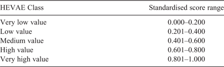
Individual attributes and overall outcomes were applied to derive an ecological value score from zero to one that informs prioritisation of GDEs for management purposes. Ecological scores were categorised into five classes – very low, low, medium, high and very high value (as per Table 8). A five-scale classification provided greater discrimination, and reduced the effect of clumping caused by using fewer categories (Macgregor et al. 2011; Healey et al. 2012).
Distinctiveness (D)
A similar approach was adopted from the riverine NSW HEVAE methods (Healey et al. 2018) to calculate a distinctiveness score for each vegetation GDE polygon. The calculations were separated into four processes before combining into a total distinctiveness score (D) (see (5) below):

where total distinctiveness score (D) where Fa is the fauna score, Fl is the flora score, VC is the vegetation community conservation score, and FC is the fisheries Endangered Ecological Community (EEC) score.
-
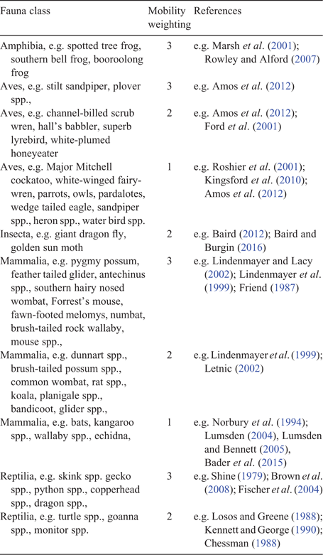
Fauna species scores (Fa): the fauna species within each individual vegetation community were identified, and the relevant distribution score (known, predicted, recorded) was applied (Table 1). The distribution (d) score for each fauna species was multiplied by its associated conservation (c) score (i.e. dc = d × c) (Table 2). The fauna species were then separated into mobility classes (M3 = low, M2 = medium or M1 = high) to allow for a mobility weighting (M) to be applied to each species (Table 3). The (dc) score within each mobility class were added together and multiplied by the mobility weighting for each class (dcM1, dcM2, dcM3) (e.g. dcM1 = sum (dc) × M1). Each of the mobility scores were then added up and the fauna score was standardised by dividing the maximum of the sum (as per Eqn 2).
-
where fauna species scores (Fa) where dcM1 is the weighted fauna score for high mobility class, dcM2 is the weighted fauna score for medium mobility class, and dcM3 is the weighted fauna score for low mobility class.
-
Flora species scores (Fl): the flora species within each individual vegetation community were identified, and the relevant distribution score (known, predicted, recorded) was applied (Table 1). The distribution (d) score for each fauna species was multiplied by its associated conservation (c) score (i.e. β = d × c) (Table 2).
-
Vegetation community conservation scores (VC): the vegetation communities within each individual vegetation community were identified, and the relevant distribution score (known, predicted, recorded) was applied (Table 1). The distribution (d) score for each vegetation community was multiplied by its associated conservation (c) score (i.e. γ = d × c) (Table 4).
-
Fisheries EECs scores (FC): the Fisheries EECs within each individual vegetation community were identified, and the predicted distribution score was applied.
-
Total distinctiveness scores (D): the four final input scores were added together and standardised by dividing by the maximum sum of the attribute scores to give a final distinctiveness score for each vegetation GDE polygon (Eqn 1).
Attribute data
Flora and fauna searches for recorded, known and predicted distributions were undertaken using the following web-based tools/databases and associated literature (Table 1). Site-based fauna and flora species records were joined to the hydrological geospatial fabric (geofabric) (BOM 2012) sub catchments to account for spatial distribution of species (ability of species to move) and associated with the vegetation GDE polygons within the sub catchments. Known and predicted species data were associated with the vegetation GDE polygons and Interim Biogeographic Regionalisation of Australia (IBRA) subregions (Environment Australia 2000; NPWS 2003). Catchment or regional recorded occurrence of vegetation-based EECs listed under the TSCA 1995, were determined through assessment of vegetation types (OEH 2015) for vegetation. Table 1 shows the scores attributed to each of the datasets. Scores of 1 were given to data that was recorded as occurring in the field whereas the known and predicted distribution data received lower scores due to this data being derived via models.

|
The ability of a species to disperse was also given a weighting with highly mobile species given a lower weighting (high = 1, medium = 2, low = 3) (OEH 2017a). The mobility weightings (M) were adopted from the environmental asset identification program for the Basin Plan Long-term Environmental Watering Plans. The mobility weighting placed a greater weighting on habitats that support less mobile species, as these are more vulnerable to habitat modifications at the local scale. These weightings were determined through literature and expert opinion of fauna experts in the Office of Environment and Heritage (OEH 2017a). Examples of research undertaken for various species mobilities are provided in Table 3 along with mobility weightings applied to each fauna class with example species in each class.
|
|
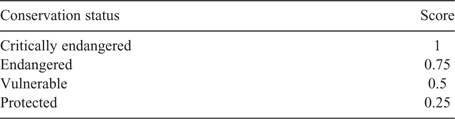
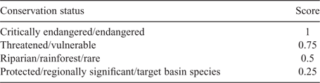
The conservation status of species (flora and fauna) and ecological communities also gained a weighting with a critically endangered species receiving a higher weighting than a protected, or regionally significant, or basin target species (Table 4). The Basin-wide environmental watering strategy (MDBA 2014a) has identified objectives and targets for riverine and floodplain vegetation which are aimed at protecting or improving the current vegetation extent, and improving vegetation community condition in parts of the Basin’s floodplain that can be actively managed. So as to align with the protection measures of vegetation by the MDBA, DoI Water has included these species into the GDE HEVAE model with a weighting of 0.25 unless they have a higher conservation status via state or Commonwealth legislation (i.e. basin target species).
|
Diversity (Dh)
Diversity was calculated by adding up each attribute score to get a total score. Total score was standardised by dividing the maximum of the sum of the attribute scores to give a final diversity score for each vegetation GDE polygon (Eqn 3).

where total diversity score (Dh) where PA is patch area and PN is distance between patches.
Attribute data
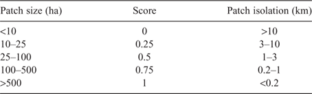
Habitat diversity was determined by using habitat types associated with size characteristics of patch size and isolation (i.e. distance between patches). Patches were defined as a polygon not directly connected to any other polygon of the same plant community type (PCT). The patch size and isolation were calculated for each vegetation GDE patch by measuring the patch area (PA)and the distance between patches (PN) in ArcGIS. Numerous studies have grouped remnant patches into size groupings for the purposes of their field studies (e.g. Bennett 1987; Lindenmayer et al. 1999; Lindenmayer et al. 1999). The patch size groupings in these methods were aimed at taking into account the importance of the larger patches and the areas of less isolation in maintaining species diversity and populations were based upon previous field studies (Bennett 1987; Lindenmayer et al. 1999; Mac Nalley et al. 2000; Table 5). The larger the patch sizes the closer the score approaches 1. The closer the vegetation GDE patch is to another patch, the closer the score approaches 1 as shown in Table 5.
|
Vital habitat (V)
Vital habitat was calculated by adding each of the four attribute scores to get a total score. The total score was standardised by dividing the maximum of the sum of the attribute scores to give a final vital habitat score for each vegetation GDE polygon (Eqn 4):

where total vital habitat score is V, W is wetlands, S is springs, Vc is vegetation condition, and BTS is basin target species.
Attribute data
For the vital habitat criteria the attributes of springs (S), RAMSAR/DIWA wetlands (W), vegetation condition (Vc) and basin target species (BTS) were used with vegetation polygons given a score based upon presence or absence of a parameter. Both DIWA and Ramsar criteria are heavily focussed on wetlands being recognised as unique or rare habitats, and as key (vital) habitats for different flora and fauna. Several the DIWA and Ramsar criteria relate closely to the definition of vital habitat under the HEVAE framework (Aquatic Ecosystems Task Group 2012). In the GDE HEVAE method any vegetation polygon which contained Ramsar/DIWA wetlands received a score of 1. To account for any potential size or influence of a spring in an area the point location of a spring was tagged to the geofabric subcatchment. Any GDE vegetation polygon that was within one of these geofabric subcatchments received a score of 1. For basin target species, any GDE vegetation polygon that contained black box, lignum, river red gums or coolibah in the plant community type received a score of 1.
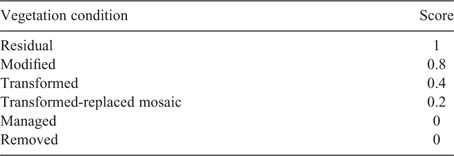
The vegetation condition data was obtained from the state of the catchment reporting (Dillon et al. 2009). The vegetation condition categories where adopted from the state of the catchment reports (Dillon et al. 2009) with managed and removed categories receiving a zero weighting. The applied scores for the vegetation condition categories are shown in Table 6.
|
Naturalness (N)
Naturalness was calculated by summing up each attribute score to get a total score. The total score was standardised by dividing the maximum of the sum of the attribute scores to give a final naturalness score for each vegetation GDE polygon (Eqn 5):

where total naturalness score is N, NPE is national parks estate, CDI is catchment disturbance index, %v is the percentage of native/non-native vegetation, and PEA is vegetation patch edge to area ratio.
Attribute data
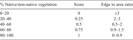
The attributes used to define naturalness were national parks estate (NPE) (considered less disturbed by human activity), catchment disturbance index (CDI) from the river condition index (RCI) (Healey et al. 2012), the percentage of native/non-native vegetation (%v) within each geofabric sub-catchment and the vegetation patch edge to area ratio (PEA).
Areas with national parks estate received a weighted score of 1. The catchment disturbance index scores were adopted straight from the RCI (Healey et al. 2012). The catchment disturbance index integrates infrastructure, land use and land cover change into one index within the river condition index and were incorporated into the naturalness criteria as calculated in the river condition index (Healey et al. 2012). The percentage of native/non-native vegetation and edge ratio to area scores are shown in Table 7.
|
Overall GDE HEVAE Score
The overall GDE HEVAE score (Eqn 6) was determined for each vegetation GDE polygon by adding together the final scores for each criterion (distinctiveness (D), diversity (Dh), vital habitat (V) and naturalness (N)) and standardising that value by dividing by the maximum overall GDE HEVAE score for vegetation GDE polygons within a catchment. This method provided an even spread of score outcomes between 0 (lowest) and 1 (highest).

where overall GDE HEVAE Score where D is distinctiveness, Dh is diversity, V is vital habitat and N is naturalness.
These scores were divided into five classes (see Table 8) describing ecological value at the GDE HEVAE and criteria level. Using this type of class or category systems is an accepted practice in waterway assessment (Bennett et al. 2002; Macgregor et al. 2011; Healey et al. 2012). Each inland catchment or water sharing plan area was modelled separately to enable the attribute within each criterion to be representative within the individual catchments.
|
Model uncertainty and localised sensitivity analysis
Various data sources and types were used in the GDE HEVAE methods to define a final ecological value to groundwater dependent vegetation. We recognise that the data sources used come with their own inherent uncertainty due to various factors (e.g. how the data was initially collected and recorded, spatial resolution and errors associated with database maintenance). The majority of the data was sourced from existing databases held by NSW Office of Environment and Heritage, which are subject to data evaluation processes. Error variance is accessible via the metadata statements and data quality documents. Where possible, the accuracy of the data used has been acknowledged. The vegetation PCT data was given an overall accuracy of 58.2% (OEH 2016c). The NSW Office of Environment and Heritage applies very good criteria (where four of five of the evaluation criteria for the NSW government quality assurance framework are met) for the data held in the BioNet database for flora and fauna: OEH 2017b). The accuracy of the DPI Water high probability vegetation GDEs spatial model was determined to be 76% from rapid field verification (Eco Logical Australia 2016; Kuginis et al. 2016).
Crosetto and Tarantola (2001) noted that the evaluation of sensitivity in the output of a spatial model is difficult due to model complexity increasing the effects of interaction between datasets. One way of addressing the sensitivity in model outputs is by conducting a localised sensitivity analysis. This was achieved by individually changing each of the attribute scores to the maximum and minimum values (e.g. all the fauna scores were changed to 1 (fauna1) and 0 (fauna0)) systematically and rerunning the model to obtain new overall HEVAE scores in three representative catchments (Gwydir, Lachlan and Murrumbidgee). The attributes chosen for the sensitivity analysis were those attributes which had range categories assigned within the model (Appendix 1). The difference between the overall HEVAE scores (e.g. fauna0 – fauna1) were calculated and averaged to determine the average range score for each attribute. Each range and averaged range overall HEVAE scores are shown in Appendix 1.
Results
In the Gwydir catchment, the majority of high and very high HEVAE scores were located in the lower Gwydir compared with the upper Gwydir. These overall results were mainly driven by the diversity and distinctiveness criteria (Fig. 3) due to various attributes including Ramsar/DIWA wetlands (as part of the broader Gwydir Wetlands) and a high number of threatened flora and fauna species, endangered ecological communities (EECs) (Lowland Darling EEC, Coolibah-black box woodland EEC) and basin target vegetation species (coolibah, lignum and river red gums). The GDEs in this area provide vital habitat to a range of species especially birds and nesting mammals. Vital habitat was generally low in the upper Gwydir. Naturalness values were mostly low and medium, which was expected because the catchment vegetation is highly fragmented by irrigated and dryland agriculture. The dominant vegetation communities in the upper Gwydir catchment were river red gum riparian woodland and river oak-rough barked apple woodlands and apple-red gum-box riparian woodlands. In the lower Gwydir the vegetation communities were dominated by coolibah-river coolibah-lignum woodland wetlands and river red gum woodland wetlands.

|
In the Lachlan catchment the GDE ecological value was mainly high to very high due to the distinctiveness and diversity criteria (Fig. 4). River red gum-lignum woodland wetlands and river red gum-black box woodland communities dominated the riparian and floodplain. There was a high number of recorded threatened bird and flora species, along with other fauna having known and predicted distributions. Inland grey box woodland EEC and basin target species (river red gum, lignum and black box) were located across the catchment. Habitat diversity was also very high in this area providing extensive riparian corridors as vital habitat for birds and nesting mammals. Vital habitat and naturalness was higher in the lower Lachlan with high and very high values, while in the upper Lachlan there were low to medium values.

|
In the Murrumbidgee catchment, the GDE ecological value, were mainly classified as high and very high (Fig. 5). The very high values were due to the extent of DIWA/Ramsar wetlands in the area which provides habitat for a large number of threatened species. The dominant vegetation GDE communities were river red gum woodland wetlands, river red gum-lignum wetlands, freshwater wetlands, river red gum-black box woodlands, river red gum-yellow box woodland wetlands and cumbungi rushlands. These communities were characterised as having a high number of threatened species, endangered ecological communities of Blakely’s red gum-yellow box woodlands, extensive connected riparian corridors and basin target vegetation species (black box, lignum and river red gums). The riparian communities provide vital habitat to nesting species and contributes to ecosystem function of instream ecosystems. Generally, the GDE communities with high ecological value had large vegetation patches, were highly connected (such as riparian corridors) and had a high number of threatened species present. Vital habitat and naturalness values were lower in this catchment with only the higher values coinciding with the wetlands.

|
When comparing the GDE HEVAE and Riverine HEVAE outcomes, the GDE outcomes were generally the same or higher in ecological value than the riverine outcomes (Figs 6, 7, 8). These higher outcomes were mostly due to the higher diversity values and to some extent the higher distinctiveness values for GDE HEVAE. The GDE HEVAE diversity values were determined by habitat diversity scores (of vegetation patch area and distance between vegetation patches), whereas Riverine HEVAE diversity values were determined by fauna diversity scores (of fish and macro invertebrates). Habitat diversity supports a higher range of species diversity rather than using only fish and macro invertebrate distribution. The higher distinctiveness scores in the GDE HEVAE resulted from all threatened species used in this score, rather than just those species that were flow dependent which were used in the Riverine HEVAE. Also there were areas where the GDE HEVAE very high or high scores extended over several shorter riverine HEVAE reaches of varying scores. In these shorter reaches the number of threatened species may be present in some reaches but are absent in others.

|

|

|
Localised sensitivity analysis
Based upon the localised sensitivity analysis, the sensitivity of the overall GDE HEVAE outputs to changes in the specific attributes could be derived. The average potential sensitivity for each attribute was (lowest to highest): patch size (±0.010), flora (±0.017), fauna (±0.019), vegetation community conservation (±0.022), vegetation edge to area ratio (±0.034), CDI (±0.037), percentage native to non-native vegetation (±0.041), vegetation condition (±0.042) and patch nearness (±0.076) (Appendix 1). The potential individual and cumulative sensitivities indicated that the relative importance of each attribute was similar with slightly more emphasis on the contribution of the attributes; patch nearness, vegetation condition and percentage native to non-native vegetation to the overall GDE HEVAE scores. The most sensitive attributes and their relative sensitivities were consistent across all the catchments (Appendix 1).
Discussion
Various authors (e.g. Hatton and Evans 1998; Boulton 2005; Murray et al. 2006; Rohde et al. 2017) have identified the need for prioritisation and adaptive management frameworks for GDEs. To date there have been limited approaches published that assign an ecological value to GDEs to aid in adaptive management (Tomlinson 2011).
Previously, the NSW Office of Water in conjunction with the National Water Commission and Office of Environment and Heritage developed a conceptual risk assessment framework for coastal aquifers to aid developers assessing risk to GDEs from a development proposal (Serov et al. 2012). This framework was aimed at local scale assessment and was only applicable to coastal sand aquifers due to the assumptions and generalisations applied.
Murray et al. (2006) presented an approach for assigning ecological services and economic value rankings to GDEs. This approach provided an initial basis for using generalised assumptions to assigning an ecosystem service or ranking to all GDE classification groups (terrestrial, aquatic and subterranean) in the same process. Therefore, there was the possibility that some classification groups received a lower ranking due to isolation or size of the GDE (e.g. isolation of springs) and may offer different ecological services (e.g. aquatic GDEs versus terrestrial GDEs). DoI Water’s approach to assigning an ecological value to GDEs was aimed to provide a value to only terrestrial GDEs rather than to all GDE classification groups together within the same approach.
The GDE HEVAE method described here was applied consistently across Murray–Darling Basin catchments in NSW and enabled individual vegetation polygons based on their ecological values to be identified. The expression of scores in a GIS, allows the dataset to be spatially interrogated to determine the most sensitive criterion and metrics producing a specific score. This provides transparency in the scoring process (Aquatic Ecosystems Task Group 2012). The application of weightings allowed those groundwater dependent vegetation polygons with greater conservation value to be identified. Each of the three catchments trialled for the GDE HEVAE method had similar potential sensitivities (Appendix 1) indicating that applying the same weightings across all catchments for each attribute was suitable and that the location at which the weighted score was applied did not influence the relative importance of the attributes. The outcomes determined from the GDE HEVAE method assigned a similar or higher ecological value to the areas within distance to riverine reaches. This appeared to be due to the higher number of species and habitat diversity that was able to be considered in the GDE HEVAE. Riverine HEVAE can only include the characteristics and species that have a flow dependency. The additional dependency of groundwater in these systems then incorporates more species and habitats thus supporting riverine ecological value but increasing the ecological value to those river reaches.
The method determined outcomes to assist NSW water management activities for water sharing plans and water resource plans under the Basin Plan. The outcomes can be represented as maps to provide a visual representation of locations of vegetation communities of ecological value and as an attributed dataset to allow the user to look at each individual attribute or criteria to determine the key drivers contributing to the scores. This allows for the scheduling of GDEs (protection of GDEs under the legal instrument of the water sharing plans) with very high and high ecological value GDEs and the development of rules to protect them. The outputs were also used to inform the risk assessment process being undertaken as a requirement of the Basin Plan. The WRP risk assessment process uses the HEVAE outcomes as the consequence component of the risk matrix. This risk process has previously been used in the macro planning approach for the development of WSPs (NSW Office of Water 2010).
Future uses of the generated dataset includes aiding in site selection for the monitoring, evaluation and reporting activities, use by DoI Water for assessments for groundwater access licences and state significant development project application assessment for impacts to GDEs from groundwater extraction, and as a base dataset for future research on terrestrial GDEs.
Conclusion
The adaption of the Commonwealth HEVAE framework was the next progressive step to aid in the management of vegetation GDEs in NSW. The methods developed have provided a useful approach to integrate a range of related information to prioritise areas of importance for water management needs such as; scheduling of GDEs into water sharing plans, using as a basis of the consequence scores within risk assessments, and to allow individuals locate GDEs of varying ecological value to inform other assessments and prioritisation of areas to undertake monitoring and evaluation. The GDE HEVAE methods have provided a robust, spatially enabled ecological value dataset at the vegetation patch scale for GDEs. The approach is systematic, repeatable and transparent. When coupled with the NSW Riverine HEVAE methods, ecological value of assigned groundwater and riverine GDEs are consistently assigned.
Conflicts of interest
The authors declare no conflicts of interest.
Acknowledgements
We are grateful for the sharing of data from OEH including vegetation mapping and fauna mobility scores. We thank Grant Hose, Danielle Baker, Christobel Ferguson and Anthony O’Grady for providing review comments for this paper. This research did not receive any specific funding.
References
Amos JN, Bennett AF, Mac Nally R, Newell G, Pavlova A, Radford JQ, Thomson JR, White M, Sunnucks P (2012) Predicting landscape-genetic consequences of habitat loss, fragmentation and mobility for multiple species of woodland birds. PLoS One 7, e30888| Predicting landscape-genetic consequences of habitat loss, fragmentation and mobility for multiple species of woodland birds.Crossref | GoogleScholarGoogle Scholar | 22363508PubMed |
Aquatic Ecosystems Task Group (2012) Aquatic ecosystems toolkit. Module 3: guidelines for identifying high ecological value aquatic ecosystems (HEVAE). Australian Government, Canberra, ACT.
Bader E, Jung K, Kalko EKV, Page RA, Rodriguez R, Sattler T (2015) Mobility explains the response of aerial insectivorous bats to anthropogenic habitat change in the neotropics. Biological Conservation 186, 97–106.
| Mobility explains the response of aerial insectivorous bats to anthropogenic habitat change in the neotropics.Crossref | GoogleScholarGoogle Scholar |
Baird IRC (2012) The wetland habitats, biogeography and population dynamics of Petalura gigantean (Odonata: Petaluridae) in the Blue Mountains of New South Wales. PhD thesis, The University of Western Sydney, School of Science and Health, NSW, Australia.
Baird IRC, Burgin S (2016) Conservation of a groundwater-dependent mire-dwelling dragonfly: implications of multiple threatening processes. Journal of Insect Conservation 20, 165–178.
| Conservation of a groundwater-dependent mire-dwelling dragonfly: implications of multiple threatening processes.Crossref | GoogleScholarGoogle Scholar |
Bender DJ, Contreras TA, Fahrig L (1998) Habitat loss and population decline: a meta-analysis of the patch size effect. Ecology 79, 517–533.
| Habitat loss and population decline: a meta-analysis of the patch size effect.Crossref | GoogleScholarGoogle Scholar |
Bennett AF (1987) Conservation of mammals within a fragmented forest environment: the contributions of insular biogeography and autecology. In ‘Nature conservation: the role of remnants of native vegetation’. (Eds DA Saunders, GW Arnold, AA Burbidge, AJM Hopkins) pp. 41–52. (Surrey Beatty & Sons Pty Ltd: Sydney, NSW)
Bennett J, Sanders N, Moulton D, Phillips N, Lukacs G, Walker K, Redfern F (2002) ‘Guidelines for protecting Australian waterways.’ (Land and Water Australia: Canberra, ACT)
BOM (Bureau of Meteorology) (2012) Australian hydrological geospatial fabric (Geofabric) product guide. Ver. 2.1 – November 2012. Available at: http://www.bom.gov.au/water/geofabric/ (accessed 31 August 2019).
Boulton A (2005) Chances and challenges in the conservation of groundwaters and their dependent ecosystems. Aquatic Conservation: Marine & Freshwater Ecosystem 15, 319–323.
| Chances and challenges in the conservation of groundwaters and their dependent ecosystems.Crossref | GoogleScholarGoogle Scholar |
Breitbach N, Laube I, Steffan-Dewenter I, Böhning-Gaese K (2010) Bird diversity and seed dispersal along a human land-use gradient: high seed removal in structurally simple farmland. Oecologia 162, 965–976.
| Bird diversity and seed dispersal along a human land-use gradient: high seed removal in structurally simple farmland.Crossref | GoogleScholarGoogle Scholar | 20049479PubMed |
Brown GW, Bennett AF, Potts JM (2008) Regional faunal decline – reptile occurrence in fragmented rural landscapes of south-eastern Australia. Wildlife Research 35, 8–18.
| Regional faunal decline – reptile occurrence in fragmented rural landscapes of south-eastern Australia.Crossref | GoogleScholarGoogle Scholar |
Buchmann CM, Schurr FM, Nathan R, Jeltsch F (2013) Habitat loss and fragmentation affecting mammal and bird communities—The role of interspecific competition and individual space use Ecological Informatics 14, 90–98.
Cadenasso ML, Pickett STA (2001) Effect of edge structure on the flux of species into forest interiors. Conservation Biology 15, 91–97.
| Effect of edge structure on the flux of species into forest interiors.Crossref | GoogleScholarGoogle Scholar |
Chessman BC (1988) Habitat preferences of freshwater turtles in the Murray Valley, Victoria and New South Wales. Australian Wildlife Research 15, 485–491.
| Habitat preferences of freshwater turtles in the Murray Valley, Victoria and New South Wales.Crossref | GoogleScholarGoogle Scholar |
Clayton PD, Fielder DP, Howell S, Hill CJ (2006) ‘Aquatic biodiversity assessment and mapping method (AquaBAMM): a conservation values assessment tool for wetlands with trial application in the Burnett River catchment.’ (The Environmental Protection Agency: Brisbane, Qld)
Commonwealth of Australia (2012) ‘Water Act 2007 – Basin Plan.’ (Commonwealth of Australia and Murray-Darling Basin Authority: Canberra, ACT)
Commonwealth of Australia (2014) Ecological and hydrogeological survey of the Great Artesian Basin springs – Springsure, Eulo, Bourke and Bogan River supergroups. Vol. 1: History, ecology and hydrogeology, knowledge report. Prepared by UniQuest for the Department of the Environment, Commonwealth of Australia, Canberra, ACT.
Costanza R, d’Arge R, de Groot R, Farber S, Grasso M, Hannon B, Limburg K, Naeem S, O’Neill RV, Paruelo J, Raskin RG, Sutton P, van den Belt M (1997) The value of the world’s ecosystem services and natural capital. Nature 387, 253–260.
| The value of the world’s ecosystem services and natural capital.Crossref | GoogleScholarGoogle Scholar |
Crosetto M, Tarantola S (2001) Uncertainty and sensitivity analysis: tools for GIS-based model implementation. International Journal of Geographical Information Science 15, 415–437.
| Uncertainty and sensitivity analysis: tools for GIS-based model implementation.Crossref | GoogleScholarGoogle Scholar |
Cushman SA (2006) Effects of habitat loss and fragmentation on amphibians: a review and prospectus. Biological Conservation 128, 231–240.
| Effects of habitat loss and fragmentation on amphibians: a review and prospectus.Crossref | GoogleScholarGoogle Scholar |
DEE (2016) Australian wetlands database. Commonwealth Department of Environment and Energy. Available at: https://www.environment.gov.au/water/wetlands/australian-wetlands-database (accessed 31 August 2019).
Dendy J, Cordell S, Giardina CP, Hwang B, Polloi E, Rengulbai K (2015) The role of remnant forest patches for habitat restoration in degraded areas of Palau. Restoration Ecology 23, 872–881.
| The role of remnant forest patches for habitat restoration in degraded areas of Palau.Crossref | GoogleScholarGoogle Scholar |
Dillon M, McNellie M, Oliver I (2009) ‘Technical background report NSW state of the catchments 2008: Native vegetation.’ (ECC: Sydney, NSW)
Diogo IJS, Borges e Silva R, Morais EB, Salmito Melo IR, Voltolini JC (2012) Effects on the vegetation structure in a fragment of semi-deciduous forest, northeastern Brazil. Revista Biociências Taubaté 18, 53–60.
DIPNR (2005) ‘Macro water planning process for unregulated streams: a manual to assist regional agency staff and regional panels to develop water sharing rules in accordance with the Minister’s requirements.’ (NSW Department of Infrastructure, Planning and Natural Resources: Sydney, NSW)
DPI (2015a) Threatened and protected species – records viewer. NSW Department of Primary Industries. Available at: http://www.dpi.nsw.gov.au/fisheries/species-protection/records (accessed 18 May 2015).
DPI (2015b) Listed threatened species, populations and ecological communities. NSW Department of Primary Industries. Available at: http://www.dpi.nsw.gov.au/fishing/species-protection/conservation/what-current (accessed 18 May 2015).
DPI Water (2017a) Lachlan water resource plan: surface water resource description. NSW Department of Primary Industries, Water, Sydney, NSW.
DPI Water (2017b) Gwydir water resource plan: surface water resource description. NSW Department of Primary Industries, Water, Sydney, NSW.
DPI Water (2017c) Murrumbidgee water resource plan: surface water resource description. NSW Department of Primary Industries, Water, Sydney, NSW.
Eamus D, Froend R, Loombes R, Hose GC, Murray BR (2006) A functional methodology for determining the groundwater regime needed to maintain health of groundwater dependent ecosystems. Australian Journal of Botany 54, 97–114.
| A functional methodology for determining the groundwater regime needed to maintain health of groundwater dependent ecosystems.Crossref | GoogleScholarGoogle Scholar |
Eco Logical Australia (2016Rapid field verification for groundwater dependent ecosystem vegetation; Hunter, Namoi and Lachlan catchments. Prepared for NSW Department of Primary Industries, Water, September 2016.)
Environment Australia (2000) ‘Revision of the interim biogeographic regionalisation of Australia (IBRA) and the development of version 5.1. – summary report.’ (Department of Environment and Heritage: Canberra, ACT)
Environment Australia (2001) ‘A directory of important wetlands in Australia.’ 3rd edn. (Environment Australia: Canberra, ACT)
Ewers RM, Thorpe S, Didham RK (2007) Synergistic interactions between edge and area effects in a heavily fragmented landscape. Ecology 88, 96–106.
| Synergistic interactions between edge and area effects in a heavily fragmented landscape.Crossref | GoogleScholarGoogle Scholar | 17489458PubMed |
Fahrig L, Merriam G (1994) Conservation of fragmented populations. Conservation Biology 8, 50–59.
| Conservation of fragmented populations.Crossref | GoogleScholarGoogle Scholar |
Fischer J, Lindenmayer DB, Cowling A (2004) The challenge of managing multiple species at multiple scales: reptiles in an Australian grazing landscape. Journal of Applied Ecology 41, 32–44.
| The challenge of managing multiple species at multiple scales: reptiles in an Australian grazing landscape.Crossref | GoogleScholarGoogle Scholar |
Fletcher RJ (2005) Multiple edge effects and their implications in fragmented landscapes. Journal of Animal Ecology 74, 342–352.
| Multiple edge effects and their implications in fragmented landscapes.Crossref | GoogleScholarGoogle Scholar |
Ford HA, Barrett GW, Saunders DA, Recher HF (2001) Why have birds in the woodlands of southern Australia declined? Biological Conservation 97, 71–88.
| Why have birds in the woodlands of southern Australia declined?Crossref | GoogleScholarGoogle Scholar |
FMA (1994) Fisheries Management Act 1994 No. 38. (NSW)
Friend JA (1987) Local decline, extinction and recovery: relevance to mammal populations in vegetation remnants. In ‘Nature conservation: the role of remnants of native vegetation’. (Eds DA Saunders, GW Arnold, AA Burbidge, AJM Hopkins) pp. 53–64. (Surrey Beatty & Sons Pty Ltd: Sydney, NSW)
Goodman SM, Rakotondravony D (2000) The effects of forest fragmentation and isolation on insectivorous small mammals (Lipotyphla) on the Central High Plateau of Madagascar. Journal of Zoology 250, 193–200.
| The effects of forest fragmentation and isolation on insectivorous small mammals (Lipotyphla) on the Central High Plateau of Madagascar.Crossref | GoogleScholarGoogle Scholar |
Goosem M (2000) Effects of tropical rainforest roads on small mammals: edge changes in community composition. Wildlife Research 27, 151–163.
| Effects of tropical rainforest roads on small mammals: edge changes in community composition.Crossref | GoogleScholarGoogle Scholar |
Guerry AD, Hunter ML (2002) Amphibian distributions in a landscape of forests and agriculture: an examination of landscape composition and configuration. Conservation Biology 16, 745–754.
| Amphibian distributions in a landscape of forests and agriculture: an examination of landscape composition and configuration.Crossref | GoogleScholarGoogle Scholar |
Hatton T, Evans R (1998) Dependence of ecosystems on groundwater and its significance to Australia. LWRRDC Occasional Paper No. 12/98. Land and Water Resources Research and Development Corporation, Canberra, ACT.
He T, Krauss SL, Lamont BB, Miller BP, Enright NJ (2004) Long-distance seed dispersal in a metapopulation of Banksia hookeriana inferred from a population allocation analysis of amplified fragment length polymorphism data. Molecular Ecology 13, 1099–1109.
| Long-distance seed dispersal in a metapopulation of Banksia hookeriana inferred from a population allocation analysis of amplified fragment length polymorphism data.Crossref | GoogleScholarGoogle Scholar | 15078448PubMed |
Healey M, Raine A, Parsons L, Cook N (2012) ‘River condition index in New South Wales: method development and application.’ (NSW Office of Water: Sydney, NSW)
Healey M, Raine A, Lewis A, Hossain B, Hancock F, Sayers J, Dabovic J (2018) ‘Applying the High Ecological Value Aquatic Ecosystem (HEVAE) framework to water management needs in NSW.’ (NSW DoI Water: Sydney, NSW)
Hughey KF (2013) Development and application of the river values assessment system for ranking New Zealand river values. Water Resources Management 27, 2013–2027.
| Development and application of the river values assessment system for ranking New Zealand river values.Crossref | GoogleScholarGoogle Scholar |
Kennard MJ (Ed.) (2010) Identifying high conservation value aquatic ecosystems in northern Australia. Interim Report for the Department of Environment, Water, Heritage and the Arts and the National Water Commission. Charles Darwin University, Darwin, NT.
Kennett RM, George A (1990) Habitat utilization and its relationship to growth and reproduction of the eastern long-necked turtle, Cheixidina longicollis (Testudinata: Chelidae), from Australia. Herpetologica 46, 22–33.
Kingsford RT, Roshier DA, Porter JL (2010) Australian waterbirds: time and space travellers in dynamic desert landscapes. Marine and Freshwater Research 61, 875–884.
| Australian waterbirds: time and space travellers in dynamic desert landscapes.Crossref | GoogleScholarGoogle Scholar |
Kuginis L, Dabovic J, Byrne G, Raine A, Hemakumara H (2016) ‘Methods for the identification of high probability groundwater dependent vegetation ecosystems.’ (DPI Water: Sydney, NSW)
Laan R, Verboom B (1990) Effects of pool size and isolation of amphibian communities. Biological Conservation 54, 251–262.
| Effects of pool size and isolation of amphibian communities.Crossref | GoogleScholarGoogle Scholar |
Lawley V, Lewis M, Clarke K, Ostendorf B (2016) Site-based and remote sensing methods for monitoring indicators of vegetation condition: an Australian review. Ecological Indicators 60, 1273–1283.
| Site-based and remote sensing methods for monitoring indicators of vegetation condition: an Australian review.Crossref | GoogleScholarGoogle Scholar |
Lehtinen RM, Galatowitsh SM, Tester JR (1999) Consequences of habitat loss and fragmentation for wetland amphibian assemblages. Wetlands 19, 1–12.
| Consequences of habitat loss and fragmentation for wetland amphibian assemblages.Crossref | GoogleScholarGoogle Scholar |
Letnic M (2002) Long distance movements and the use of fire mosaics by small mammals in the Simpson Desert, central Australia. Australian Mammalogy 23, 125–134.
| Long distance movements and the use of fire mosaics by small mammals in the Simpson Desert, central Australia.Crossref | GoogleScholarGoogle Scholar |
Lindenmayer DB, Lacy RC (2002) Small mammals, habitat patches and PVA models: a field test of model predictive ability. Biological Conservation 103, 247–265.
| Small mammals, habitat patches and PVA models: a field test of model predictive ability.Crossref | GoogleScholarGoogle Scholar |
Lindenmayer DB, Cunningham RB, Pope ML (1999) A large-scale experiment to examine the effects of landscape context and habitat fragmentation on mammals. Biological Conservation 88, 387–403.
| A large-scale experiment to examine the effects of landscape context and habitat fragmentation on mammals.Crossref | GoogleScholarGoogle Scholar |
Losos JB, Greene HW (1988) Ecological and evolutionary implications of diet in monitor lizards. Biological Journal of the Linnean Society. Linnean Society of London 35, 379–407.
| Ecological and evolutionary implications of diet in monitor lizards.Crossref | GoogleScholarGoogle Scholar |
Loyn RH (1987) Effects of patch area and habitat on bird abundances, species numbers and tree health in fragmented Victorian forests. In ‘Nature Conservation: the role of remnants of native vegetation’. (Eds DA Saunders, GW Arnold, AA Burbidge, AJM Hopkins) pp. 65–78. (Surrey Beatty & Sons Pty Ltd: Sydney, NSW)
Lumsden LF (2004) The ecology and conservation of Insectivorous bats in rural landscapes. PhD thesis, Deakin University, School of Life and Environmental Sciences, Melbourne, Vic., Australia.
Lumsden LF, Bennett AF (2005) Scattered trees in rural landscapes: foraging habitat for insectivorous bats in south-eastern Australia. Biological Conservation 122, 205–222.
| Scattered trees in rural landscapes: foraging habitat for insectivorous bats in south-eastern Australia.Crossref | GoogleScholarGoogle Scholar |
Mace GM, Harvey PH (1983) Energetic constraints on home range size. American Naturalist 121, 120–132.
| Energetic constraints on home range size.Crossref | GoogleScholarGoogle Scholar |
Macgregor C, Cook B, Farrell C, Mazzella L (2011) ‘Assessment framework for prioritising waterways for management in Western Australia.’ (Centre of Excellence in Natural Resource Management, University of Western Australia: Albany, WA)
Mac Nalley R, Bennett AF, Horrocks G (2000) Forecasting the impacts of habitat fragmentation. Evaluation of species-specific predictions of the impact of habitat fragmentation on birds in the box-ironbark forests of central Victoria, Australia. Biological Conservation 95, 7–29.
Marsh DM, Trenham PC (2001) Metapopulation dynamics and amphibian conservation. Conservation Biology 15, 40–49.
McCarthy M, Lindenmayer DB (1999) Incorporating metapopulation dynamics of greater gliders into reserve design in disturbed landscapes. Ecology 80, 651–667.
| Incorporating metapopulation dynamics of greater gliders into reserve design in disturbed landscapes.Crossref | GoogleScholarGoogle Scholar |
MDBA (2014a) ‘Basin-wide environmental watering strategy.’ (Murray-Darling Basin Authority: Canberra, ACT)
MDBA (2014b) ‘Reviewing the scientific basis of environmental water requirements in the Condamine–Balonne and Barwon–Darling.’ (Murray–Darling Basin Authority: Canberra, ACT)
MDBA (2018) Discover groundwater. Available at: https://www.mdba.gov.au/discover-basin/water/discover-groundwater (accessed 23 July 2018).
Murcia C (1995) Edge effects in fragmented forests: implications for conservation. Trends in Ecology & Evolution 10, 58–62.
| Edge effects in fragmented forests: implications for conservation.Crossref | GoogleScholarGoogle Scholar |
Murray BR, Hose GC, Eamus D, Licari D (2006) Valuation of groundwater-dependent ecosystems: a functional methodology incorporating ecosystem services. Australian Journal of Botany 54, 221–229.
| Valuation of groundwater-dependent ecosystems: a functional methodology incorporating ecosystem services.Crossref | GoogleScholarGoogle Scholar |
Negus PM, Blessing J, Clifford S (2012) Developing an Integrated Ecological Condition Assessment (IECA) framework for high ecological value aquatic ecosystems in an arid landscape: the Cooper Creek catchment trial. Report prepared for the Aquatic Ecosystems Task Group and the Department of Sustainability, Environment, Water, Population and Communities. Queensland Department of Environment and Resource Management, Brisbane, Qld.
Norbury GL, Norbury DC, Oliver AJ (1994) Facultative behaviour in unpredictable environments: Mobility of red kangaroos in arid Western Australia. Journal of Animal Ecology 63, 410–418.
| Facultative behaviour in unpredictable environments: Mobility of red kangaroos in arid Western Australia.Crossref | GoogleScholarGoogle Scholar |
NPWS (2003) ‘The bioregions of New South Wales: their biodiversity, conservation and history.’ (NSW National Parks and Wildlife Service: Hurstville, NSW)
NSW Office of Water (2010) Macro water sharing plans: the approach for unregulated rivers. Report to assist community consultation. NSW Office of Water. Available at: http://www.water.nsw.gov.au/Water-management/Water-sharing-plans/planning-process/default.aspx (accessed 31 August 2019).
OEH (2015) ‘Border Rivers, Gwydir and Namoi native vegetation mapping.’ (NSW Office of Environment and Heritage: Sydney, NSW)
OEH (2016a) Threatened species profile search. NSW Office of Environment and Heritage. Available at: http://www.environment.nsw.gov.au/threatenedSpeciesApp/ (accessed 13 September 2016).
OEH (2016b) About the atlas of NSW wildlife. NSW Office of Environment and Heritage. Available at: http://www.environment.nsw.gov.au/wildlifeatlas/about.htm (accessed 13 September 2016).
OEH (2016c) State vegetation type map. User accuracy of plant community type models. NSW Office of Environment and Heritage. Available at: http://www.environment.nsw.gov.au/vegetation/state-vegetation-type-map.htm (accessed 31 August 2019).
OEH (2017a) Technical report – mapping of water dependent environmental assets – application of schedule 8 of the basin plan. (OEH: Sydney, NSW)
OEH (2017b) NSW BioNet species sightings data collection. NSW Government data quality statement: 4 December 2017. Available at: http://data.environment.nsw.gov.au/dataset/9fc66776-fae7-47d2-8d63-e8fa638ec898/resource/data_quality_report/pdf (accessed 31 August 2019).
Oliver I, Eldridge DJ, Nadolny C, Martin WK (2014) What do site condition multi-metrics tell us about species biodiversity? Ecological Indicators 38, 262–271.
| What do site condition multi-metrics tell us about species biodiversity?Crossref | GoogleScholarGoogle Scholar |
Ottaviani D, Cairns SC, Oliverio M (2006) Body mass as a predictive variable of home-range size among Italian mammals and birds. Journal of Zoology 269, 317–330.
| Body mass as a predictive variable of home-range size among Italian mammals and birds.Crossref | GoogleScholarGoogle Scholar |
Paton PWC (1994) The effect of edge on avian nest success: how strong is the evidence? Conservation Biology 8, 17–26.
| The effect of edge on avian nest success: how strong is the evidence?Crossref | GoogleScholarGoogle Scholar |
Peles JD, Bowne DR, Barrett GW (1999) Influence of landscape structure on movement patterns of small mammals. In ‘Landscape ecology of small mammals’. (Eds GW Barrett, JD Peles) pp. 41–62. (Springer Science Business Media: New York)
Recher HF, Shields J, Kavanagh R, Webb G (1987) Retaining remnant mature forest for nature conservation at Eden, New South Wales: A review of theory and practice. In ‘Nature conservation: the role of remnants of native vegetation’. (Eds DA Saunders, GW Arnold, AA Burbidge, AJM Hopkins) pp. 178–194. (Surrey Beatty & Sons Pty Ltd: Sydney, NSW)
Richardson S, Irvine E, Froend R, Boon P, Barber S, Bonneville B (2011) Australian groundwater-dependent ecosystem toolbox. Part 1: Assessment framework. Waterlines report, National Water Commission, Canberra.
Rohde MM, Froend R, Howard J (2017) A global synthesis of managing groundwater dependent ecosystems under sustainable groundwater policy. Ground Water 55, 293–301.
| A global synthesis of managing groundwater dependent ecosystems under sustainable groundwater policy.Crossref | GoogleScholarGoogle Scholar | 28419432PubMed |
Roshier DA, Robertson AI, Kingsford RT, Green DG (2001) Continental-scale interactions with temporary resources may explain the paradox of large populations of desert waterbirds in Australia. Landscape Ecology 16, 547–556.
| Continental-scale interactions with temporary resources may explain the paradox of large populations of desert waterbirds in Australia.Crossref | GoogleScholarGoogle Scholar |
Rothermel BB (2004) Migratory success of juveniles: a potential constraint on connectivity for pond-breeding amphibians. Ecological Applications 14, 1535–1546.
| Migratory success of juveniles: a potential constraint on connectivity for pond-breeding amphibians.Crossref | GoogleScholarGoogle Scholar |
Rowley JJL, Alford RA (2007) Movement patterns and habitat use of rainforest stream frogs in northern Queensland, Australia: implications for extinction vulnerability. Wildlife Research 34, 371–378.
| Movement patterns and habitat use of rainforest stream frogs in northern Queensland, Australia: implications for extinction vulnerability.Crossref | GoogleScholarGoogle Scholar |
Saunders DA, Hobbs RJ, Margules CR (1991) Biological consequences of ecosystem fragmentation: a review. Conservation Biology 5, 18–32.
| Biological consequences of ecosystem fragmentation: a review.Crossref | GoogleScholarGoogle Scholar |
Schmid-Holmes S, Drickamer LC (2001) Impact of forest patch characteristics on small mammal communities: a multivariate approach. Biological Conservation 99, 293–305.
| Impact of forest patch characteristics on small mammal communities: a multivariate approach.Crossref | GoogleScholarGoogle Scholar |
Serov P, Kuginis L, Williams JP (2012) ‘Risk assessment guidelines for groundwater dependent ecosystems. Vol. 1. The conceptual framework.’ (NSW Department of Primary Industries, Office of Water: Sydney, NSW)
Shine R (1979) Factors affecting the use of reforested sites by reptiles in cleared rainforest landscapes in tropical and subtropical Australia. Herpetologica 35, 1–11.
Simberloff DA (1988) The contribution of population and community biology to conservation science. Annual Review of Ecology and Systematics 19, 473–511.
| The contribution of population and community biology to conservation science.Crossref | GoogleScholarGoogle Scholar |
Standish RJ, Cramer VA, Wild SL, Hobbs RJ (2007) Seed dispersal and recruitment limitation are barriers to native recolonization of old-fields in Western Australia. Journal of Applied Ecology 44, 435–445.
| Seed dispersal and recruitment limitation are barriers to native recolonization of old-fields in Western Australia.Crossref | GoogleScholarGoogle Scholar |
Tomlinson M (2011) Ecological water requirements of groundwater systems: a knowledge and policy review: waterlines report. National Water Commission, Canberra, ACT.
TSCA (1995) Threatened Species Conservation Act 1995 No. 101. (NSW)
Tulloch AIT, Barnes MD, Ringma J, Fuller RA, Watson JEM (2016) Understanding the importance of small patches of habitat for conservation. Journal of Applied Ecology 53, 418–429.
Wilcove DS, Rothstein D, Dubow J, Phillips A, Losos E (1998) Quantifying threats to imperilled species in the United States. Bioscience 48, 607–615.
| Quantifying threats to imperilled species in the United States.Crossref | GoogleScholarGoogle Scholar |
Appendix 1. Local sensitivity analysis results for each attribute in each individual catchment and an overall average
HEVAE is High Ecological Value Aquatic Ecosystems. Values given are for catchment overall average sensitivity scores (deviation range)

|