

An overview of the SkyTEM airborne EM system with Australian examples
James Reid A D , Andrew Fitzpatrick B and Kate Godber CA Geoforce Division of Groundprobe, 1/288 Victoria Road, Malaga, WA 6090, Australia.
B CSIRO Earth Science and Resource Engineering, PO Box 1130, Bentley, WA 6102, Australia.
C Geoforce Division of Groundprobe, 8 Hockings Street, South Brisbane, Qld 4101, Australia.
D Corresponding author. Email: james.reid@groundprobe.com
Preview 2010(145) 26-37 https://doi.org/10.1071/PVv2010n145p26
Published: 14 April 2010
Introduction
SkyTEM is a high-resolution helicopter-borne time-domain electromagnetic system. The system is very versatile and can be very easily configured, with most parameters being software selectable in the field. This versatility makes the system applicable to a wide variety of geological problems.
The principal features of the SkyTEM system are as follows:
-
SkyTEM is a calibrated system designed to give quantitative electromagnetic data across a wide time range, as required for detailed investigations where it is often necessary to be able to distinguish geological units with very slight differences in conductivity. Ancillary data measured by the system includes laser altitude, GPS elevation, transmitter loop attitude, and peak transmitter current for each transient, enabling rigorous quantitative interpretation of the electromagnetic data.
-
The instrument is uniquely capable of operating in dual moment mode, combining the high shallow and lateral resolution offered by early time data measured at high base frequency and low current, with the large depth of investigation from later time measurements at low base frequency and high transmitter moment. The transmitter can easily be configured to operate at a range of base frequencies and delay times, and the measurements can therefore be optimised for a range of target depths and conductivities.
-
The receiver coils measure both vertical (Z) and horizontal in-line (X) components of the secondary voltage response. The X-component provides additional resolution of lateral conductivity contrasts and steeply dipping conductors.
-
The receiver coils are placed so as to be null-coupled to the primary field of the transmitter, in order to minimise the self-response of the system. The bias signal from the transmitter is very low, and no levelling of the electromagnetic data is required. As a consequence data can be processed and inverted in the field, allowing rapid assessment of survey results and planning of infill lines etc. whilst a survey is in progress.
-
The low flight height provides high lateral resolution and improved shallow depth resolution.
-
Advanced quantitative interpretation programs are available. Fast approximate layered earth interpretation using iTEM can be performed faster than the rate of data acquisition, enabling very rapid data turnaround. Full nonlinear laterally or spatially constrained inversion can provide improved resolution of layer depths and allows straightforward application of constraints on the conductivity model both laterally and with depth. Incorporation of additional constraints on the inversion, based on geological considerations or additional geophysical data, can be readily performed.
SkyTEM has been deployed in Australia since late 2006, and is operated by Geoforce Pty Ltd under an agreement with SkyTEM Aps, Denmark. Survey objectives in Australia have included groundwater exploration, salinity mapping, contaminated site and tailings dam assessment, and exploration for a range of mineral commodities, including channel iron deposits, palaeochannel and unconformity-hosted uranium, gold, manganese and base metals. Surveys have been successfully and safely conducted in both remote and urban areas, including around active industrial and mine sites. Australian clients have included Federal and State geoscientific, water resources and environmental organisations, CSIRO, and major and junior mineral exploration companies.
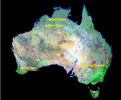
This paper will discuss the technical specifications of the SkyTEM system including a brief summary of the data processing and inversion techniques applied to the data. It will then present results from a number of case studies at locations around Australia (see Figure 1).
|
Technical
The SkyTEM system has a number of novel design features which distinguish it from other helicopter transient electromagnetic systems operating in Australia.
Configuration
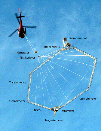
The system is carried as an external sling load, and is independent of the helicopter. A small navigation screen is installed in the helicopter, which receives positional and altitude information via wireless link from GPS antennae and laser altimeters mounted on the transmitter loop frame (Figure 2). Other essential operating parameters, such as transmitter current and temperature, battery voltages, pitch and roll of the transmitter loop etc. are also available to the pilot. All navigational and operating parameters can also be received by the ground crew when within radio modem range. The SkyTEM transmitter is powered by a motor generator mounted on the tow cable.
|
In Australia, surveying is conducted using light helicopters such as AS350BA or AS350B2. Average survey groundspeeds are 80–100 km/h, although the transmitter frame can be rigged for speeds of 60 km/h or lower if required for detailed surveying around built-up areas or in very rugged terrain. In favourable flying conditions e.g., long flight lines and flat terrain, sustained production rates of 400–500 km/day have been regularly achieved.
The instrument geometry is fixed, with the transmitter loop, receivers and all ancillary instruments rigidly mounted on the transmitter loop frame. A 314 m2 transmitter loop has been used for the majority of surveys conducted in Australia, although a 494 m2 loop is also available. Ancillary instruments include two independent GPS receivers, two independent laser altimeters and two sets of independent inclinometers, providing redundancy in the case of instrument failure while the system is airborne. The redundant ancillary datasets are also very useful during quality control of survey data. Each inclinometer set measures the tilt of the frame from horizontal both in and perpendicular to the flight direction. The rigid geometry of the system means that the DGPS position and inclinometer information can be used to determine the exact position of all sensors in three dimensions. Tilt information is used to correct measured laser altimeter data to the vertical, and can also be used to perform an approximate correction of the EM data for transmitter attitude (Auken et al., 2009).
Transmitter
The SkyTEM system has been designed to provide calibrated electromagnetic data over a wide range of delay times. The SkyTEM transmitter is capable of operating in several different modes.
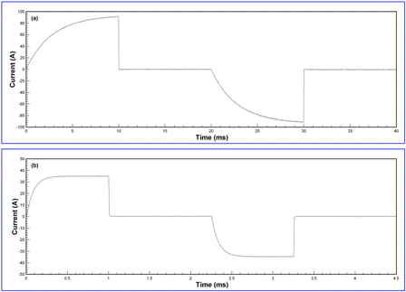
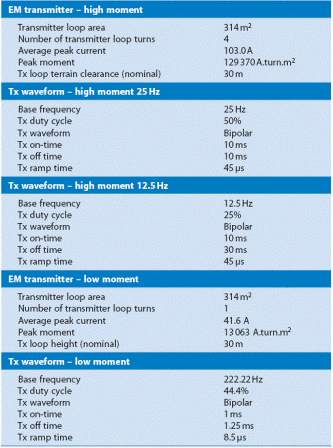
High-moment (HM) mode uses four transmitter turns and a peak current of ~100 A. Ramp time in HM mode is typically 45 μs. Base frequency may be either 25 or 12.5 Hz in regions with 50 Hz powerlines, or 30/15 Hz where the powerline frequency is 60 Hz. The 25 Hz base frequency uses a 50% duty cycle, and yields gate centre times from the start of the current ramp of between 71 μs and 8.8 ms. The 12.5 Hz base frequency employs a 25% duty cycle, with an on-time of 10 ms and off-time of 30 ms. The maximum gate centre time at 12.5 Hz is 26.6 ms.
Low-moment (LM) mode uses a single transmitter loop turn and a peak current of ~40 A. Base frequency in this mode is 222.2 Hz, with an on-time of 1 ms and off-time of 1.25 ms. Ramp time is typically ~8 μs. LM gate centre times typically range from 14.2 μs to 0.897 ms.
Other transmitter modes, such as Super Low Moment (SLM; Auken et al., 2009) allow unbiased data from 10 μs, but to date have not been employed in surveys in Australia.
Examples of HM and LM current waveforms measured in the field are shown in Figure 3.
|
The SkyTEM data acquisition script is software controlled, and data may be acquired solely in HM or LM modes, or using a combination of the two (dual moment). In dual moment mode, data is sequentially acquired at HM and LM. Noise measurements with the transmitter off can also be included in the acquisition script – these can provide useful information on background noise levels which may be utilised during inversion of the data. The unique flexibility of the SkyTEM instrument means that acquisition can be optimised for a particular geological objective. The fast turn-off and early sampling times of the LM mode provide high shallow resolution and increased sensitivity to weakly conductive targets, while the higher current and late delay times of the HM mode provide a large depth of investigation.
The peak transmitter current for each transient is recorded and is used in data processing and inversion.
The main transmitter parameters are summarised in Table 1.
|
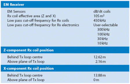
Receivers
The sensors are shielded overdamped coils with an effective area after preamplification of 105 m2 and a low-pass cutoff frequency of 450 kHz. Both X and Z-components of dB/dt are measured, with the coils placed in positions at the edge of the transmitter loop where they are approximately null-coupled to the primary field of the transmitter. Detailed aspects of the signal detection scheme are given by Sørensen and Auken (2004). Note however that some of the waveform and filtering schemes described by them have since been superseded, as described in this article. The receiver electronics have a user-selectable low-pass filter. A value of 300 kHz is often used to avoid distortion of the early-time response, which is critical for providing reliable shallow information. Each individual transient is recorded, along with important ancillary data such as peak current.
The main receiver parameters are summarised in Table 2.
|
Data processing
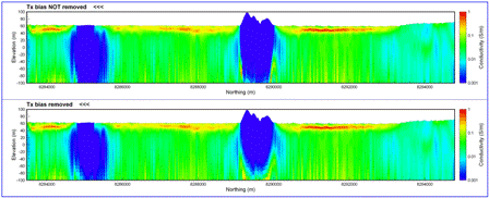
An important aspect of the SkyTEM design is that the receiver coils are null-coupled to the primary field of the transmitter. This minimises transmitter bias and means that regular excursions to high altitude to monitor the bias response are not necessary during each flight. In practice, high altitude flights are only required at the start of a survey to confirm correct operation of the instrument, and at approximately weekly intervals thereafter. The transmitter bias measured at high altitude can be compared with the response measured at survey altitude. Rather than attempt to correct for the bias by subtracting the response measured at high altitude, channels where the bias is >2% of the earth response are not used for subsequent processing and inversion. For surveys where the dual transmitter mode is employed, the LM mode provides unbiased data at those high moment channels for which the bias signal is strongest, so there is no loss of information when biased early-time HM channels are excluded.
Figure 4 shows comparsions of iTEM fast approximate layered-earth inversions of the data from a large survey at Ord River, Western Australia. The inversion was performed on data without (top panel) and with (lower panel) the bias removed. There are only very minor differences between the two cross-sections, even at shallow depths where the effect of any bias should be largest. The similarity of the inversion results demonstrates that the bias is negligible in comparison with the earth response in this example.
|
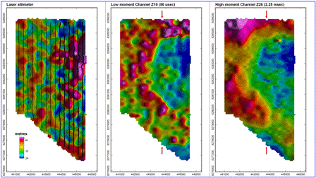
The very small bias signal means that preliminary presentation and inversion of SkyTEM data can be performed without the need for any substantial data processing or levelling. Figure 5 shows plan images of SkyTEM data from two abutting survey flights conducted during the Ord River survey, which were flown 17 days apart. No processing other than stacking of the data has been performed. Images of the Z-component EM data at LM Channel 10 and HM Channel 26 show that data from the two flights stitches together seamlessly, even when sunshaded from the direction perpendicular to the flight lines. The minimal data processing requirements for SkyTEM mean that inversions can be performed on field-processed data, which yield results very similar to those from final office-based processing, as illustrated by Figure 4. Using the iTEM fast approximate layered-earth inversion code (Christensen, 2002; Christensen and Tølbøll, 2009), inverted SkyTEM data is now routinely delivered the morning after data acquisition.
|
Quantitative interpretation
A number of quantitative tools have been applied to SkyTEM data, including EMaxAir CDIs (Fullagar and Reid, 2001; Fullagar et al., 2008); iTEM fast approximate layered-earth inversion (FA-LEI; Christensen, 2002; Christensen and Tølbøll, 2009; Christensen et al., 2009) and the full nonlinear laterally constrained inversion (LCI) from Aarhus Geophysics (Auken et al., 2005, 2009; Viezzoli et al., 2009).
iTEM
iTEM is a fast, robust, approximate inversion that yields smooth multilayer layered-earth inversions (LEI) in a fraction of the time required for conventional nonlinear inversion. Each individual sounding is inverted independently (as in conventional LEI). Layer thicknesses are fixed and the data is inverted for the layer resistivities only. The iTEM LEI is now the standard method used to invert SkyTEM data in Australia, due to its extremely fast computation speed and parallelised processing. A standard field laptop with a single CPU is capable of performing iTEM inversion of SkyTEM data faster than it can be acquired. During office-based processing on computers with 8–16 CPU, an entire day’s worth of field data can be inverted for a 30-layer model in less than 30 min. Despite the approximations made in the algorithm, iTEM yields smooth conductivity models comparable to those obtained via full nonlinear multilayer inversion.
LCI
In LCI (Auken et al., 2005), a group of TEM soundings are inverted simultaneously using 1D models. Each sounding yields a separate layered model, but the models are constrained laterally on a number of model parameters such as resistivity, layer thickness and/or depth to layer boundaries, i.e. these parameters are permitted to vary only gradually along a profile. The degree of lateral constraint can be set by the user depending on the local geology. The result of the LCI inversion is a quasi-2D model section that varies smoothly along the profile. The LCI inversion is also capable of simultaneously inverting the interleaved HM and LM measurements, yielding a conductivity model that combines the very good shallow depth resolution offered by the low moment data and the larger depth of investigation from the HM data. HM and LM models are linked via the lateral constraints, meaning that the well-resolved shallow information derived from the LM data provides a shallow constraint on the neighbouring HM inversions, and the deep information from the HM data constrains the deeper part of the adjacent LM models.
The LCI code can be run in two basic modes: in few-layer inversion, both the model resistivities and thicknesses are allowed to vary during the inversion, as in a standard LEI. The multi-layer, smooth model mode is similar to that used by iTEM, i.e. the layer thicknesses are fixed and the data are inverted only for resistivity. The LCI smooth-model inversion typically uses fewer layers (12–19) than iTEM. Smoothness constraints are applied on the variation of resistivity with depth, in additional to the lateral constraints between adjacent models. Few-layer LCI inversion gives sharp resolution of layer boundaries and is faster to compute because of the small number of model parameters. However, few-layer inversion can fail if there are insufficient layers in the model to fit the observed responses. Multi-layer smooth-model inversion is slower to compute, but is usually able to provide a very close fit to the observed data. Precise depths of subsurface interfaces are more difficult to determine from smooth-model inversion results.
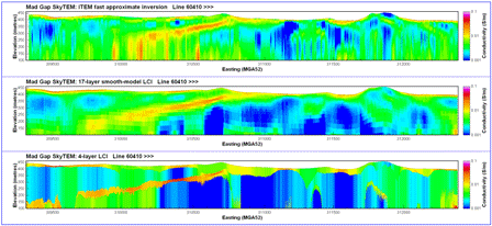
Figure 6 shows a line of SkyTEM data from Mad Gap, Western Australia, which has been inverted using the iTEM LEI, 17-layer smooth-model LCI, and a 4-layer LCI with additional constraints on the layer resistivities. The profile consists of 588 HM soundings and 237 LM soundings. iTEM inversion of this dataset required a total of 152 s of CPU time on a single processor. This is faster than the time taken to collect the data (165 s was taken for the helicopter to physically fly the line). Note that the computation time can be further reduced by parallel computation on multiple CPU, as is routinely done with larger datasets (i.e. ~20 s computation time for the same line using 8 CPU).
|
The 17-layer LCI has yielded a result quite similar to that obtained from iTEM, although deep artifacts (vertical striping) in the iTEM section have been removed. The main west-dipping conductive layer also appears to have been somewhat better resolved at depth by the LCI. The 17-layer LCI required 14 760 s to compute on a single CPU, or 97 times the time required for the iTEM inversion. As for iTEM, the computation time could have been reduced by invoking the parallel computation capability in the Aarhus Workbench software (~30 min computation time assuming 8 CPU).
The iTEM and 17-layer LCI inversions suggest that the geoelectric structure in the vicinity of the main west-dipping conductor generally comprises four layers, with three layers (conductor, resistor, conductor) overlying a resistive basement. Constraints were applied to the layer resistivities in order to reflect this conductivity structure, with the aim of improving resolution of the main dipping conductor. Starting layer resistivities were estimated from the smooth model LCI results, and the first and third layers were constrained to be conductive and the other two layers to be resistive. The final 4-layer model shows very good agreement with both iTEM and the 17-layer LCI. The 4-layer LCI model appears to provide the best definition of the main dipping conductor, particularly at depth where the conductor appears to be more laterally continuous than in the other inversion sections. The time required to compute the 4-layer model was 2580 s on a single CPU, or 17 times that required for the iTEM inversion.
Field examples
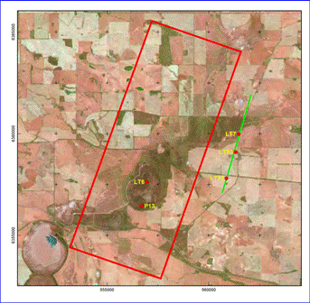
Toolibin Lake
The initial field trial of SkyTEM in Australia was conducted at Toolibin Lake, Western Australia (Reid et al., 2007). The hydrogeology of Toolibin Lake has been extensively studied, and the area has been the subject of two previous airborne electromagnetic surveys (SALTMAP and TEMPEST) as well as numerous surface and downhole geophysical surveys. The extent of the 2006 SkyTEM survey is shown in Figure 7.
|
The geology in the survey area comprises Quaternary and Tertiary alluvial sediments overlying weathered Archaean granite and granite gneiss cross-cut by Proterozoic mafic dykes. The unweathered Archaean basement is generally highly resistive. Regolith thickness ranges up to 60 m and averages 25 m. Groundwater is highly saline (up to ~36 000 mg/L), and in-situ conductivities of sediments and weathered bedrock determined by previous geophysical surveys range up to 700 mS/m.
The TEMPEST AEM survey conducted in 1998 revealed the presence of an extensive palaeochannel system beneath Toolibin Lake, and extending to the northeast (Lane and Pracilio, 2000). The palaeochannel sands and gravels exhibit slightly lower electrical conductivity than surrounding saprolitic clays and overlying lacustrine clays.
The SkyTEM survey at Toolibin Lake repeated the earlier TEMPEST survey. The survey was flown with dual moment (HM and LM). Line direction was north-northeast at a spacing of 150 m, as for the earlier TEMPEST survey. Nominal terrain clearance was 30 m.
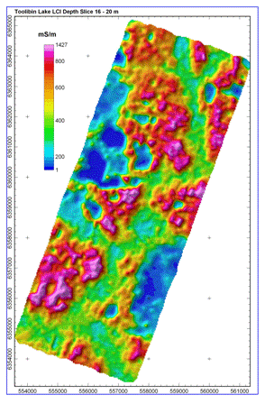
A number of different inversions of the Toolibin Lake SkyTEM dataset have been conducted, including both 6- and 15-layer LCI (Reid et al., 2007), and a laterally constrained fast approximate approach (Christensen et al., 2009). An interval conductivity slice derived from the LCI model for the depth range 16–20 m below surface is shown in Figure 8. The relatively resistive palaeochannel sands extend from the NNE of the survey block to the SSW to its SSW extremity, and appear as light-green to light-blue on the image (300–400 mS/m). In addition to the main channel, a number of smaller tributaries have also been defined.
|
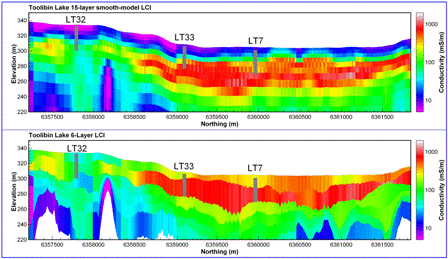
Figure 9 shows a comparison of 15-layer smooth-model and 6-layer LCI from a 5 km long testline flown outside the main survey block at Toolibin Lake (Figure 7). A number of drillholes have been superimposed on the LCI conductivity cross-sections. These were auger holes, which were terminated upon encountering consolidated material, and so the depth of the holes provides an indication of the depth to competent bedrock. Depth to bedrock is extremely well mapped by the 6-layer LCI in the central part of the line (drillholes LT33 and LT7), where the granite bedrock is overlain by highly conductive clays and saprolite, and there is an abrupt decrease in conductivity at the bedrock interface. The smoothness constraints applied to the vertical variation of conductivity in the 15-layer LCI do not allow rapid conductivity changes with depth, with the result that the saprolite–bedrock boundary is not imaged as well in the smooth model. The effectiveness of SkyTEM in mapping the depth to bedrock in this instance stems from the high sensitivity of EM measurements to the conductivity and thickness of the highly conductive layer immediately overlying the resistive bedrock.
|
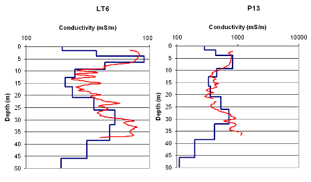
Figure 10 shows a comparison of EM39 inductive conductivity logs from drillholes LT6 and P13 located within Toolibin Lake with the closest 15-layer LCI models. The LCI results show excellent correspondence with the conductivity logs, illustrating the good calibration of the SkyTEM system. The agreement between the borehole logs and the SkyTEM models suggests that the geoelectric structure is laterally homogeneous within the lake, i.e. that the geology is fairly uniform over the SkyTEM footprint.
|
Ord River Survey
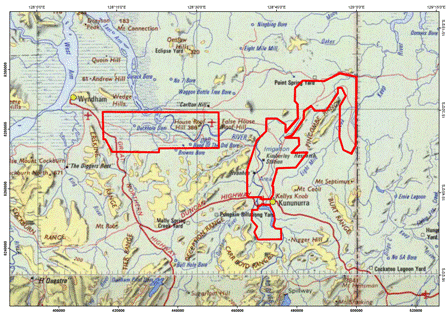
The Ord River Valley SkyTEM survey was flown to help inform groundwater and salinity management practices in the current Ord Irrigation Area (ORIA) and future proposed irrigation developments, and to examine surface–groundwater interactions in neighbouring environmental wetlands. The airborne survey acquisition was undertaken as part of a collaborative project between the Ord Irrigation Cooperative, Geoscience Australia and CSIRO (Lawrie et al., 2010).
The survey encompassed the areas of ORIA Stage 1, Parrys Lagoon, Carlton Hill and Keep River areas (Figure 11). A total of 5936 line km of data was acquired between July and August 2008, using a dual moment (HM and LM) configuration.
|
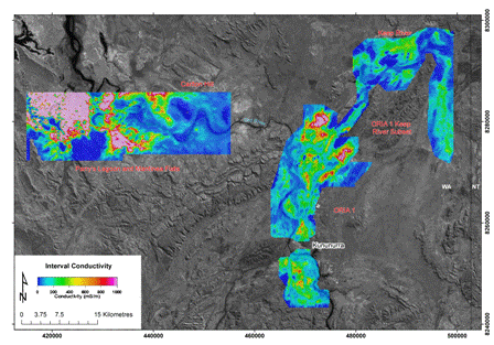
The HM and LM SkyTEM data for the Ord survey were inverted using a 1D LCI (Auken et al., 2005).The resultant conductivity model can be presented as plan form, either depth below surface or elevation slices, vertical cross sections or stitched together to produce quasi-3D models. An example of conductivity-depth plan for 4.2–6.7 m below the surface is shown in Figure 12.
|
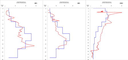
A total of 45 boreholes within the survey areas were logged with an induction tool to support the validation of the SkyTEM data. An example of comparing individual induction logs against the smooth model SkyTEM conductivity model is shown in Figure 13. Generally, for all 45 boreholes the modelled conductivity structure defined from the SkyTEM smooth model LCI matches that defined from the bore data, except in the fine detail. The models derived from the SkyTEM data provide a reasonable approximation to ‘true’ ground conductivity, as defined by the borehole conductivity tool.
|
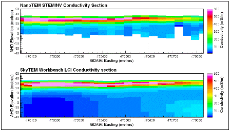
The SkyTEM LCI conductivity model can also be compared to ground NanoTEM data collected using a 20 × 20 m transmitter loop by Lawrie et al. (2006) within the Ord Irrigation Area 1 (ORIA1). The NanoTEM data was inverted using Zonge’s STEMINV1D (MacInnes and Raymond, 2001) program to produce a smooth model conductivity model. The equivalent SkyTEM section was extracted from gridded data at 80 m cell size, and thus is expected to smooth conductivity features horizontally. The modelled conductivity structure defined from the SkyTEM smooth model LCI closely matches that defined from the NanoTEM smooth model (Figure 14). The comparison highlights the excellent vertical resolution that can be achieved by SkyTEM. In this example a conductive layer 6 m thick has been imaged at depths of only a few metres.
|
The conductivity model produced from the Ord Valley SkyTEM survey appears to be well calibrated and accurate when compared to borehole and ground EM data. This provides confidence in using the resultant model to accurately interpret the 3D hydrogeological framework of the study area and identify salinity risks. Interpretations of this dataset have been used to populate 3D hydrogeological models to help inform groundwater and irrigation management of the Ord Valley area.
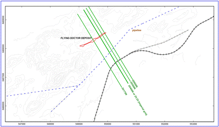
Flying Doctor
The Flying Doctor deposit is a Pb–Zn–Ag deposit near Broken Hill, NSW, which has been used as a geophysical test range over the last few decades (e.g., Boyd and Wiles, 1984; Cattach and Boggs, 2005). Numerous surface, downhole and airborne electromagnetic and electrical surveys have been conducted over the deposit. The detailed geometry of the mineralisation is quite complex (see cross-sections in Cattach and Boggs, 2005). In summary, the thin lenses of mineralisation strike roughly northeast and dip steeply (80º) to the northwest. The main mineralisation lies at depths of 10–150 m. In long section, the mineralisation is ‘boomerang’ shaped, and is shallowest (10–15 m) at its centre (~flight line 20400 in Figure 15) and deepest at its southwestern and northeastern ends.
|
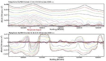
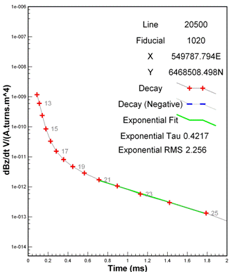
Figure 16 shows a subsection of flightline 20500, showing well-defined Z- and X-component anomalies from the Flying Doctor mineralisation at ~6468475N. The X-component anomaly is well-developed (i.e. shows a clear crossover) by Channel 16 (226 μs), at which time the double-peaked Z-component anomaly is just starting to appear. The presence of both X and Z-component anomalies improves confidence in both identification of the anomaly and in interpretation of the response. The mineralisation is only moderately conductive, presumably as a result of high sphalerite content, and the anomaly only persists in the Z-component until Channel 25 (1.79 ms). Exponential fitting of the later-time part of the decay yields a time constant of 0.42 ms (Figure 17). Boyd and Wiles (1984) obtained a time constant of 1.5 ms, from Newmont EMP downhole electromagnetic (DHEM) data measured to later delay times than used for the SkyTEM survey.
|
|
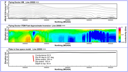
Figure 18 is a multiplot showing the measured Z-component SkyTEM response on a 1 km section of line 20500, the iTEM fast approximate LEI computed from the Z-component, and a plate-in-free-space model obtained by fitting the observed Z- and X-component anomalies using Maxwell. The Maxwell model shows that the observed anomaly can be explained by a single plate-like body dipping steeply to the northwest. The modelled plate has a depth to top of 40 m, dip of 85 degrees to 327º, strike extent of 350 m, depth extent of 100 m and conductance of 50 S, and is consistent with the known location of the highest-grade mineralisation on this line. The modelled conductance is in reasonable agreement with Boyd and Wiles (1984), who derived a conductance of 110 S based on their DHEM data.
|
The iTEM LEI was able to achieve a good fit to the observed Z-component data, but has resulted in two strong conductors underneath the peaks of the Z-component anomaly at 6468425mN and 6468510mN. The iTEM conductors also lie considerably deeper (65–90 m) than the Maxwell plate model. This example clearly illustrates the inapplicability of one-dimensional conductivity-depth transformation (e.g., LEI or CDI) in strongly 2D or 3D geology. Layered-earth transformations of SkyTEM data have been found to yield reasonable results for dips up to approximately 30 degrees. For more steeply dipping targets, one-dimensional models incorrectly represent the conductor geometry and overestimate the depth. Rapid layered-earth inversion of mineral exploration data is still considered useful both for fast identification of conductors and for determination of parameters such as overburden thickness and conductivity, which may influence the plate modelling.
Conclusions
SkyTEM is a quantitative electromagnetic system designed to be able to resolve small differences in conductivity. The system provides calibrated electromagnetic data over a wide time range and has excellent lateral and shallow resolution and a depth of exploration of up to 400 m in favourable geological settings. Measurement of transmitter altitude and inclination, and well-established filter parameters and transmitter current waveform mean that rigorous quantitative interpretation is possible. Comparisons with drilling results and borehole conductivity logs presented in this paper demonstrate the calibration of the system.
As with all airborne electromagnetic systems, SkyTEM is continuously evolving. Current active areas of hardware and software development are focussed on improving both the depth of investigation and near-surface resolution.
Author profile
James Reid holds BSc (Hons) and MSc Degrees in geophysics from the University of Sydney and a PhD in geophysics from Macquarie University. From 1999 to 2006 he was a lecturer in geophysics at the University of Tasmania. He is currently a Principal Geophysicist with Groundprobe (Geoforce Division) in Perth, Western Australia. His current technical focus is on airborne electromagnetic methods.
Acknowledgements
Andrew Bisset from U3O8 Ltd is thanked for permission to publish the Mad Gap example. The Ord River project was co-funded by the Australian Government in partnership with the Western Australian Government and undertaken under the auspices of the National Action Plan for Salinity and Water Quality, and managed by Ord Irrigation Cooperative (OIC) for the WA Rangelands Natural Resource Management Group. Perilya Ltd kindly provided access to their tenements for acquisition of the Flying Doctor dataset. JR would also like to thank Max Halkjaer and Per Gisselø of SkyTEM Aps, Denmark; Esben Auken and Andrea Viezzoli of Aarhus Geophysics Aps Denmark, and Niels Christensen of EMModel, Denmark for technical discussions over the last few years. Tim Munday (CSIRO), Dean Rogers (Perilya Ltd) and Max Halkjaer are thanked for their comments on an earlier draft of this article.
Auken, E , Christiansen, AV , Jacobsen, BH , Foged, N , and Sørensen, KI (2005). Piecewise 1D Laterally Constrained Inversion of resistivity data. Geophysical Prospecting 53, 497–506.
| Crossref | GoogleScholarGoogle Scholar |
Sørensen, KI , and Auken, E (2004). SkyTEM – a new high-resolution helicopter transient electromagnetic system. Exploration Geophysics 35, 194–202.
| Crossref | GoogleScholarGoogle Scholar |

Viezzoli, A , Auken, E , and Munday, T (2009). Spatially constrained inversion for quasi 3D modelling of airborne electromagnetic data – an application for environmental assessment in the Lower Murray Region of South Australia. Exploration Geophysics 40, 173–183.
| Crossref | GoogleScholarGoogle Scholar |