

Post-stack 3D merging to fast-track regional interpretation – offshore Otway Basin case study
Merrie-Ellen Gunning A * , Scott Wilkinson B , Pei-Fei Chau B , Cameron Mitchell A and Jennifer Badry BA
B

Merrie-Ellen Gunning has an MBA and a Bachelor of Applied Science in Geology, having studied at Melbourne Business School and RMIT University. She has over three decades of industry experience. Since joining Geoscience Australia in 2015, she has worked on a wide range of prospectivity and CCS projects and is currently Director – Offshore Energy Systems. |

Scott Wilkinson has over 30 years of processing and acquisition experience working for a range of geophysical companies, predominantly in the UK and Australia. He is currently a Geoscience Team Manager at DUG Technology in Perth. Scott graduated from John Moores University with a BSc in geology and is a member of PESA. |

Pei Fei Chau is a Geophysicist at DUG Technology Australia. Since graduating in 2011, she has worked with CGG and DUG Technology in Malaysia and Australia. Her experience includes 2D and 3D marine processing (time and depth) across offshore Asia-Pacific. She has a Bachelor’s Degree in Applied Physics, from the University of Science, Malaysia graduating in 2011. |

Cameron Mitchell is a technical geoscientist at Geoscience Australia. His recent focus has been modernisation of workflows and technology. He has worked on regional tectonostratigraphic, prospectivity and CCS studies, seismic survey planning, and was the Chief Scientist of the 2007 Great Australian Bight sampling survey. Cameron has a BSc (Hons) in geology from the Australian National University from 2000. |

Jennifer Badry is a Senior Support geophysicist at DUG Technology, focussing on Full Waveform Inversion. Previously, Jennifer was a senior geophysicist working in processing and imaging. Jennifer holds a Bachelor of Science in geophysics, from the University of Alberta, and has 16 years of industry experience in seismic processing and imaging around the world. |
Abstract
Ideally when combining legacy 3D seismic surveys, differences in acquisition parameters warrant full pre-stack reprocessing from field data. However, there are occasions where this is not possible due to time, financial or data access constraints; a valuable alternative is post-stack merging and enhancement of existing migrations. This case was to produce a regularised and seamless 3D dataset of the highest possible quality, for the offshore Otway Basin, within 2 months. The input migrated volumes varied by data extent, migration methodology, angle range and grid orientation. Fourteen input volumes totalling 8092 km2 were post-stack merged and processed to produce a continuous and consistent volume, enabling more efficient and effective interpretation of the region. The surveys were regularised onto a common grid, optimised for structural trends, prior to survey matching. A mis-tie analysis algorithm, applied over a time window optimised for interpretation of key events, was used to derive corrections for timing, phase and amplitude, using a reference. This was followed by time-variant spectral and amplitude matching to improve continuity between volumes. Additional enhancements including noise removal and lateral amplitude scaling were also applied. The final merged volume offers significant uplift over the inputs, providing better imaging of structure and events and dramatically improving the efficiency and quality of interpretation. This enables rapid reconnaissance of the area by explorers.
Keywords: 3D seismic, marine seismic, Otway Basin, post-stack merge, reprocessing.
Introduction
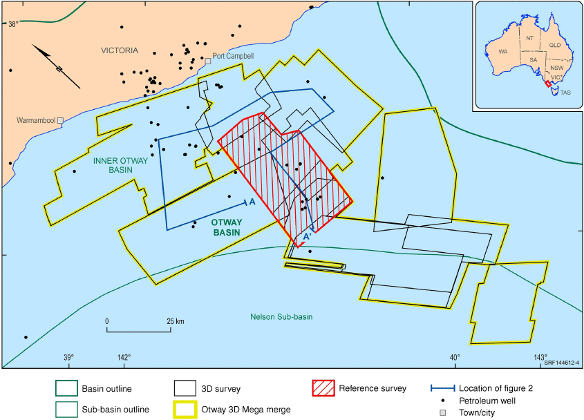
Regional interpretation and mapping of the offshore Otway Basin has been undertaken by Geoscience Australia to better understand the petroleum prospectivity of this basin (Abbott et al. 2023); in particular, the deep-water and underexplored areas. Most of the 3D seismic surveys in the offshore (Fig. 1) are in and around the Shipwreck Trough with almost continuous coverage of this part of the basin; although these are of varying vintage, two-way-time range, migration methodology, angle range and grid orientation. The task of regional interpretation in this structurally complex basin (Nicholson et al. 2024) is severely hampered when using such a diverse assortment of surveys. To expedite interpretation of this area, and to provide industry with access to a merged volume (Fig. 1), a post-stack 3D seismic merge was performed.
Post-stack 3D seismic merging
Post-stack vs pre-stack
Of course, the ideal imaging of any basin would use a pre-stack merge and migration, even when a variety of surveys are being processed. However, there are occasions where the time and/or money to undertake this work is not available. In the case of this project, both turnaround time and available budget were firm constraints on the activity, and both made the prospect of a pre-stack reprocessing solution prohibitive.
In general, post-stack merging can be used as a tool for expediting exploration. This is achieved through the interpretation element of a project to be brought forward; enabling it to progress in parallel with other activities such as pre-stack reprocessing and/or acquisition. An example is the Barrow-Dampier CCS Study (Barlass et al. 2024) where the project saved 5 months. The availability of interim horizons during pre-stack processing assists with model building, demultiple and other processing steps.
Volume selection
A number of legacy surveys, shown in Table 1, had already undergone reprocessing to combine volumes or enhance imaging. The oldest processing vintage used was the original 2000 version of the Investigator 3D survey, although most of this survey was integrated from reprocessing of the survey into combined volumes from 2006, 2012 or 2013. Care was taken to ensure none of the original survey data was lost through exclusion from subsequent reprocessing.
| Volume/survey(s) | Data type | Angle range (°) | Contractor | Year processed | Input area (km2) | |
|---|---|---|---|---|---|---|
| Antares, Champion, Casino, Hercules | PreSDM stack | 0–35 | CGG | 2014 | 1555 | |
| Astrolabe, Investigator | PreSDM stack | 3–35 | CGG | 2013 | 506 | |
| Aragorn, Bellerive, Investigator | PreSDM stack | Unknown | DUG | 2012 | 1865 | |
| Aragorn, Bellerive | QKDM stack | 5–35 | SLB | 2016 | 1154 | |
| Aragorn, Investigator | PreSTM Stack | Full offset | PGS | 2006 | 1409 | |
| Brandt | PreSDM stack | 5–35 | CGG | 2009 | 608 | |
| Crowes Foot | QKDM stack | 5–35 | SLB | 2017 | 877 | |
| Flanagan | PreSTM stack | 2–30 | DUG | 2015 | 974 | |
| Investigator | Post-stack OMEGA-X migration | Full offset | Veritas DGC | 2000 | 1047 | |
| Investigator North (reference survey) | QKDM stack | 5–35 | SLB | 2017 | 334 | |
| La Bella | PreSTM stack | 0–30 | CGG | 2014 | 1333 | |
| Minerva, Schomberg | PreSTM stack | 3–40 | Fugro | 2008 | 552 |
Source: DUG (2023).
After initial loading and quality control of the input surveys, Investigator North (Figs 1 and 2) was selected as the reference survey as it was well placed geographically, central to distribution of input volumes, and had good data quality.
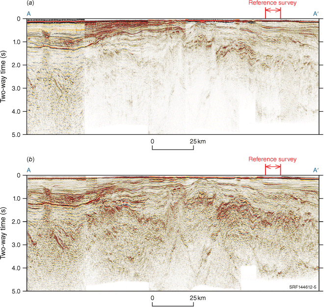
Traverse through the northern section of the Otway 3D Mega merge (left to right: La Bella; Antares, Champion, Casino, Hercules; Minerva, Schomberg; Crowes Foot; Astrolabe, Investigator; Investigator North (reference survey); Investigator; Aragorn, Bellerive) (a) input data and (b) final result.
Post-stack reprocessing
The input stacked volumes were regularised onto a common grid to cover the extent of the input volumes, with an orientation of 47.1445° to broadly match the structural orientation of that part of the Otway Basin (Nicholson et al. 2024).
DUG Technology Ltd.’s mis-tie analysis was used to match the other volumes to Investigator North in terms of time, phase and amplitude, with progressive ties being made for those surveys that did not directly overlap Investigator North. The shifts applied to each volume are reported in (DUG 2023). The maximum time shift calculated, using a 2000 ms window from 250 ms below water-bottom, was 20 ms for Brandt, however, a 2D tie line was required to tie Brandt with Bellerive, and otherwise time shifts were less than 12.5 ms.
Three surfaces were used to provide guidance to define windows for spectral matching, these were regional coarsely sampled surfaces predominantly based on 2D interpretation (Abbott et al. 2022). Windows of water-bottom – T1 (predominantly Cenozoic succession), T1 – LC2 (Sherbrook Supersequence), and LC2 + 2000 ms, were used for the matching. User-defined frequency/gain pairs were derived to match each of the volumes to the reference, with a subsequent time-variant gain derived to account for the gain differences in adjacent surveys where required.
To improve continuity between volumes, a spatially variant taper zone was used in overlapping areas to merge the volumes.
A mild time-variant noise attenuation was applied using DUG Technology Ltd.’s Cadzow filtering algorithm (Cadzow 1988; Trickett 2002) and any lateral amplitude striping, caused by geology or legacy processing techniques, were addressed in 3D to give a more consistent character across surveys. A Structural Oriented Filter was used to remove any residual acquisition footprint from the different azimuths, and mild spectral broadening enhanced both low and high frequencies. Finally, a residual gain correction of 1 dB/s was applied and the water-bottom pick was used to mute the energy above the seafloor.
Results
Interpretation
A comparison of the input data (Fig. 2a) and the output data (Fig. 2b) is illustrated in a traverse, through the northern section of the Otway 3D Mega merge. Equivalent uplift can be seen through the remaining surveys in the southern part of the Otway 3D Mega merge.
The value of the results can be measured in terms of the time and quality of interpretation. In the context of the regional mapping project, the availability of the new merged volume has enabled infilling of detail and more efficient seismic interpretation and mapping of the intra Upper Cretaceous events. It has also improved confidence in picking events that were previously considered discontinuous. The additional noise attenuation, scaling and spectral broadening, make the continuity of events better for mapping at a regional scale. The more consistent waveform appearance across a now seamless 3D grid aids the interpreter in reflector correlations and, therefore, mapping. Events within the Upper Cretaceous, at approximately 1–2 s below water bottom are easily handled by waveform propagators and automatic pickers. The complex structure (Nicholson et al. 2024) is better resolved with the ability to easily visualise the seismic when perpendicular to structural orientation, and contiguously across, what were, multiple surveys.
Field of view
The availability of a regional merged 3D dataset provides a broader field of view for interpreters. Restrictions in availability of data outside an explorer’s area of interest may be the result of cumbersome data handling, cost of data, discoverability of data or cross jurisdictional challenges. Regardless of the cause, without the broader data being visible to interpreters, the quality of the interpretation in terms of understanding the regional geological context will be adversely affected. The Otway 3D Mega merge facilitates a bigger field of view for interpreters that improves understanding of the broader geological context.
Benefits
Geoscience Australia necessarily undertakes basin-wide studies and has a broad approach to interpretation, so the value of the Otway 3D Mega merge is evident. The data is also of benefit to a diverse range of explorers. For new ventures, improved data discovery and data management, in the form of a single large volume, make the time from the initial spark of interest, to having teams working on the data, much shorter. While most of the area covered by the Otway 3D Mega merge is under title there are open areas that will benefit from faster targeting of regions for nomination and application. For those areas under title without access to commercial regional multi-client pre-stack products, ranking and re-risking of titles and prospects are improved.
Conclusion
The Otway 3D Mega merge provides an improvement in access and interpretability of seismic data across a large part of the offshore Otway Basin. It provides improved confidence in interpretation and a clearer understanding in a regional context from the inboard producing parts of the offshore Otway Basin to the frontier deep-water. This demonstrates the value of post-stack seismic merging when time and resource constraints preclude pre-stack solutions.
Benefits include reduced project time, by bringing interpretation forward; and enhanced interpretation quality and confidence, through access to broader, contiguous and better quality data. These benefits are also applicable in the use of post-stack merging in any project or activity.
Data availability
The data are available from the NOPIMS (https://www.ga.gov.au/nopims). Reprocessing ID ENO0810804.
Acknowledgements
The authors thank the team at DUG for a high-quality product under tight deadlines. Also, the staff of the Repository for expediting the delivery of input data. They also thank Chris Evenden, Donna Cathro and Yvette PoudjomDjomani for document input. This abstract is published with the permission of the CEO, Geoscience Australia.
References
Abbott S, Bernardel G, Nicholson C (2022) Offshore Otway Basin: Surface grids, isochore grids, and fault maps. Geoscience Australia, Canberra. doi:10.26186/146398
Abbott S, Cubitt C, Bernardel G, Nicholson C, Nguyen D (2023) Towards a regional understanding of Sherbrook Supersequence gross depositional environments, offshore Otway Basin. In ‘4th Australasian Exploration Geoscience Conference’, 2023, Brisbane. https://doi.org/10.5281/zenodo.7980133
Barlass D, Hamilton R, Mehay S, Parent A, Pei I, Schenk O, Gunning M, Vonk A (2024) Building a carbon dioxide storage portfolio for the Barrow-Dampier sub-basins through regional screening – an integrated geoscience approach. Australian Energy Producers Journal 64, S314-S319.
| Crossref | Google Scholar |
Cadzow JA (1988) Signal enhancement-a composite property mapping algorithm. IEEE Transactions on Acoustics, Speech, and Signal Processing 36, 49-62.
| Crossref | Google Scholar |
Nicholson C, Abbott S, Bernardel G, Poudjom Djomani Y (2024) A new perspective on regional structural architecture across the offshore Otway Basin. Australian Energy Producers Journal 64, S416-S422.
| Crossref | Google Scholar |
Merrie-Ellen Gunning has an MBA and a Bachelor of Applied Science in Geology, having studied at Melbourne Business School and RMIT University. She has over three decades of industry experience. Since joining Geoscience Australia in 2015, she has worked on a wide range of prospectivity and CCS projects and is currently Director – Offshore Energy Systems. |
Scott Wilkinson has over 30 years of processing and acquisition experience working for a range of geophysical companies, predominantly in the UK and Australia. He is currently a Geoscience Team Manager at DUG Technology in Perth. Scott graduated from John Moores University with a BSc in geology and is a member of PESA. |
Pei Fei Chau is a Geophysicist at DUG Technology Australia. Since graduating in 2011, she has worked with CGG and DUG Technology in Malaysia and Australia. Her experience includes 2D and 3D marine processing (time and depth) across offshore Asia-Pacific. She has a Bachelor’s Degree in Applied Physics, from the University of Science, Malaysia graduating in 2011. |
Cameron Mitchell is a technical geoscientist at Geoscience Australia. His recent focus has been modernisation of workflows and technology. He has worked on regional tectonostratigraphic, prospectivity and CCS studies, seismic survey planning, and was the Chief Scientist of the 2007 Great Australian Bight sampling survey. Cameron has a BSc (Hons) in geology from the Australian National University from 2000. |
Jennifer Badry is a Senior Support geophysicist at DUG Technology, focussing on Full Waveform Inversion. Previously, Jennifer was a senior geophysicist working in processing and imaging. Jennifer holds a Bachelor of Science in geophysics, from the University of Alberta, and has 16 years of industry experience in seismic processing and imaging around the world. |