

Shipwreck and Sherbrook supersequence regional gross depositional environments, offshore Otway Basin
Steve Abbott A * , Chris Cubitt B , George Bernardel A , Chris Nicholson A and Duy Nguyen AA
B

Steve Abbott holds a PhD degree in sedimentary geology from James Cook University. He joined Geoscience Australia in 2013 where he works as a Basin Analyst on regional studies of Australia’s offshore basins. Steve is a member of PESA and SEPM, and is a past president of PESA ACT. |

Chris Cubitt graduated from the University of Adelaide with a PhD in diagenesis and sedimentology. He is currently Team Leader, Basin Prospectivity at the Geological Survey of South Australia, is an author of more than 20 publications and is a member PESA, IAS and the EAGE. |

George Bernardel earned his BSc (Honours) in Geophysics from the University of Sydney in 1986. He joined Geoscience Australia in 1995 where he works as a Basin Analyst on Australia’s offshore basins. He is currently mapping Cretaceous–Cenozoic sequences and structure across the offshore Otway Basin. |

Chris Nicholson graduated with a BSc (Hons) in Geology from the Australian National University in 2000. He joined Geoscience Australia in 2004 as Basin Analyst and Structural Geologist working on regional prospectivity studies of Australia’s offshore basins. Chris is a member of PESA and SEAPEX, and is a past president of PESA ACT. |

Duy Nguyen holds BE and ME (Petroleum Engineering) degrees from the University of New South Wales. He has 5 years of oil and gas industrial experience working for Schlumberger in Australia, Malaysia, India, Middle East, and Africa. Since 2009, Duy has worked as a Petroleum Engineer at Geoscience Australia and is currently contributing to a regional study of the Otway Basin. |
Abstract
The Shipwreck and Sherbrook supersequences together constitute the upper Cretaceous succession in the Otway Basin that was deposited during an extensional basin phase. In the Shipwreck Trough, where the upper Cretaceous succession is well explored, gas fields are hosted by the Shipwreck Supersequence (SS). Elsewhere, the upper Cretaceous interval is lightly explored, and the deep-water area is considered an exploration frontier. We present regional gross depositional environment (RGDE) maps for the LC1.1 and LC1.2 sequences of the Shipwreck SS, and the LC2 Sherbrook SS. Fluvial Plain, Coastal-Delta Plain and Shelf RGDEs were interpreted from wireline logs, cores, and seismic facies. The Fluvial Plain and Coastal-Delta Plain RGDEs are mostly restricted to the inboard platform areas and the inner Morum Sub-basin. The mud-prone Shelf RGDE is widespread across the deep-water Morum and Nelson depocentres. The extent of the Fluvial and Coastal-Delta Plain belts progressively increases up-section, imparting a regressive aspect to the succession, and delineating a large fluvial-deltaic complex in the north-west of the basin. Thick seal development across the greater Shipwreck Trough, potentially mature source rocks in the deep-water basin, and thick reservoir development in the hanging wall of growth faults in the inner Morum Sub-basin are insights derived from this study, and will inform area selection for detailed gross depositional environment mapping, formulation of new hydrocarbon and carbon dioxide storage plays, and inputs for petroleum systems modelling.
Keywords: gross depositional environment, Morum Sub-basin, Nelson Sub-basin, Otway Basin, petroleum systems, seismic facies, Sherbrook Supersequence, Shipwreck Supersequence, Shipwreck Trough, Upper Cretaceous.
Introduction
The upper Cretaceous Shipwreck (Turonian–Santonian) and Sherbrook (Campanian–late Maastrichtian) supersequences (SSs) of the Otway Basin (Fig. 1a) formed during an extensional basin phase that commenced after basin-scale inversion (‘Otway Unconformity’) and ended with Australia–Antarctica separation. Both SSs consist of fluvial, coastal plain, deltaic, and marine shelf sediments. Fig. 1b shows the time-thickness variation of the upper Cretaceous succession. Across platform areas, thickness is generally less than 1.5 s TWT (two-way travel time). Beyond the outboard platform margin, the upper Cretaceous depocentre attains a thickness of over 3 s TWT. Accommodation for the upper Cretaceous depocentre was created by pronounced late Cretaceous crustal thinning and extension (Nicholson et al. 2024).
Regional geologic setting of the Otway Basin upper Cretaceous (a) Stratigraphic chart (modified from Kelman et al. (2015)) (b) Time-isochore and structural elements map. Revised basin and sub-basin boundaries are from Nicholson et al. (2024).
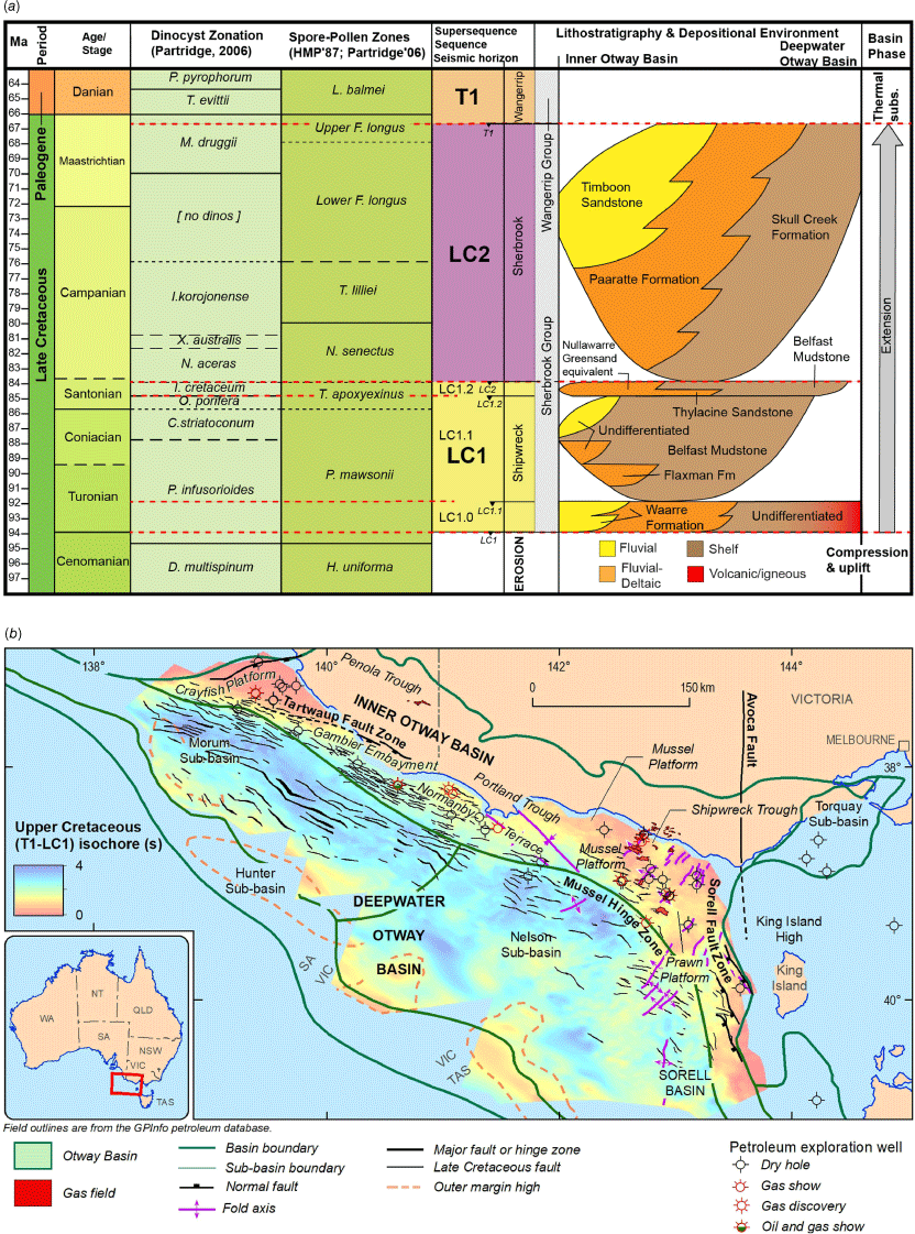
Regional gross depositional environment (RGDE) maps for the Shipwreck and Sherbrook SSs were compiled to constrain the distribution and composition of potential reservoir, seal, and source rock intervals of the upper Cretaceous Austral 3 petroleum system across the basin (Summons et al. 2002). The work presented here is part of an offshore Otway Basin pre-competitive program undertaken at Geoscience Australia. The program included acquisition of the Otway 2020 2D seismic survey over the deep-water region (Fig. 1b) and this dataset forms the basis of RGDE mapping in this under explored and poorly understood part of the basin.
RGDE characterisation
Observations from 35 wells (core and wireline logs), together with seismic facies analysis, were integrated to formulate basin scale RGDEs. The results of well-based GDE interpretation are presented in Cubitt et al. (2023) and associated data packages (Nguyen et al. 2022, 2024; Cubitt et al. 2024). Seismic facies classification integrated with well-based interpretations is presented by Abbott et al. (2023). Seismic sequence boundaries used to define RGDE intervals are included in Abbott et al. (2022). The characteristics of the main Shipwreck and Sherbrook SS RGDEs are summarised in the following, and reference core logs can be found in Cubitt et al. (2024).
Fluvial Plain RGDE
The Fluvial Plain RGDE includes fluvial channel (anastomosing and meandering), crevasse splay, flood plain, and channel abandonment environments. The seismic facies include discontinuous and locally shingled reflections, in alternation with high amplitude continuous reflections. Reference core logs for this RGDE are from Minerva 1.
Coastal-Deltaic Plain RGDE
The Coastal-Delta Plain RGDE includes mouth bar, distributary channel, channel abandonment, shoreface, and delta front environments. Seismic expression is similar to the Fluvial Plain RGDE but is distinguished by a relative abundance of delta-scale clinoform packages. Reference core logs for this RGDE are from Casino 4 and La Bella 1.
Shelf RGDE
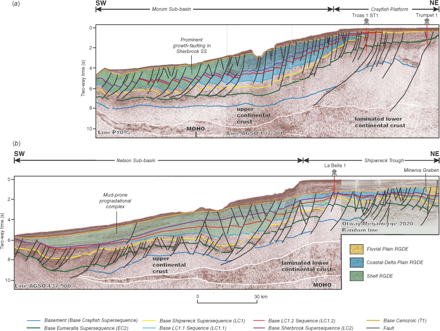
The Shelf RGDE includes marine mud-prone inner-, middle-, and outer-shelf depositional environments. High-frequency, continuous, variable amplitude reflections characterise this seismic facies. Reference core logs for this RGDE are from La Bella 1. In the Morum Sub-basin, the Shelf RGDE displays prominent divergent stratal geometries associated with growth-faulting (Fig. 2a). In contrast, in the Nelson Sub-basin, the Shelf RGDE is distinguished by shelf-scale clinoforms (Fig. 2b). The dominance of marine mud for the Shelf RGDE is consistent with the sigmoidal character of clinoforms within the progradational complex.
Interpreted seismic profiles showing RGDE distribution across the (a) Crayfish Platform and Morum Sub-basin, and (b) Shipwreck Trough and Nelson Sub-basin. Profile locations are shown in Fig. 3.
RGDE maps
For each mapped interval, the distribution of RGDE on seismic lines was constrained by well control and seismic facies (Fig. 2). Markers placed on RGDE boundaries on seismic profiles were used to guide the creation of RGDE polygons in plan view. Using this approach, three maps (Fig. 3) were prepared:
Regional gross depositional environment maps for the (a) Shipwreck Supersequence (LC1.1 sequence) (b) Shipwreck Supersequence (LC1.2 sequence) and (c) Sherbrook Supersequence. Well names and offshore well-based GDE data can be found in Nguyen et al. (2022, 2024).
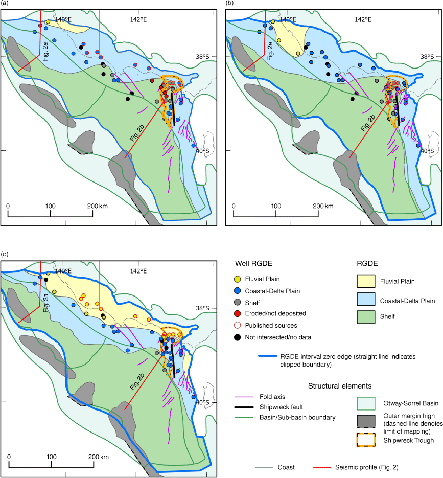
Basin-wide map coverage was completed using published sources for the onshore basin. Transitions between RGDEs occur over distances of a few kilometres to several tens of kilometres.
Discussion and conclusions
The Shipwreck and Sherbrook SSs were deposited during a second phase of Otway Basin extension, and prior to the breakup of Australia and Antarctica. Plate tectonic reconstructions show that the Otway Basin was a NW–SE oriented embayment, flanked by the Australian continent to the north and east, Antarctica to the south, and faced the incipient Southern Ocean to the west. The RGDE maps in Fig. 3 reflect this broad palaeogeographic setting, as each is dominated by a marine Shelf RGDE across the deep-water region, a medial belt of Coastal-Delta Plain RGDE, and Fluvial Plain RGDE variably developed along the northeastern inboard basin margin.
The RGDE maps show fairly extensive development of the Coastal-Delta Plain and Fluvial Plain RGDEs over the Morum Sub-basin and adjacent platform area and depicts the development of a major fluvial-deltaic system that was active throughout the late Cretaceous. This system increases in extent across the three intervals depicted in the maps, progressively encroaches into the Morum Sub-basin, and coincides with the thickest accumulation of upper Cretaceous strata in the Morum depocentre (Fig. 1b). The upper Cretaceous deltaic complex in the northwest Otway Basin is analogous to the Hammerhead Delta (Krassay and Totterdell 2003) in the Bight Basin.
Each RGDE map shows a palaeogeographic embayment of Shelf RGDE over the central platform area which diminished in size as the fluvial-deltaic complex prograded into the basin. The embayment incorporates the Shipwreck Trough, a relatively subtle feature visible on the upper Cretaceous time-isochore map (Fig. 1b). Accommodation within the Shipwreck Trough has been influenced by the large Minerva Graben, several smaller half-graben and graben, and syn-depositional folding. Accommodation was enhanced along the eastern margin of the Shipwreck Trough by development of the Shipwreck Fault (Fig. 3), a N–S trending, basement involved, strike-slip fault zone.
Hydrocarbon accumulations primarily sourced and reservoired within the Shipwreck and Sherbrook supersequences (i.e. Austral 3 petroleum system) have yet to be discovered, probably because these intervals are immature across the explored inner Otway Basin (Totterdell et al. 2014). Gas accumulations reservoired in the Waarre and Flaxman formations (LC1.0 sequence, Fig. 1a) in the Shipwreck Trough are charged by Austral 2 (lower Cretaceous Eumeralla Supersequence) source rocks. These are sealed by thick Shelf RGDE (LC1.1 and LC1.2 sequences) and trapped within faulted anticlines and tilted fault blocks. This study confirms that accumulations in the Shipwreck Trough rely on the presence of the thick Shelf RGDE seal (i.e. ‘Belfast Mudstone’ regional seal of the Otway Basin literature) and now places this play configuration within a sequence stratigraphic and GDE context. The maps presented here indicate that distribution of this important seal play element and, therefore Shipwreck SS prospectivity, is greater in area than the published boundary of the Shipwreck Trough (Cliff et al. 2004, Fig. 3). Further, deltaic reservoir facies (Thylacine Sandstone and other seismically imaged bodies) are sealed within the Shelf to Coastal-Delta Plain RGDE transition of the LC1.2 sequence (Fig. 1a).
Petroleum systems modelling (Schenk et al. 2023) and geochemical analysis from outboard wells indicate that the Austral 3 petroleum system may have operated within the Sherbrook SS in the deep-water part of the basin where it is more deeply buried. The presence of thick intervals of marine mudstone (Shelf RGDE) interpreted across the deep-water basin indicate the potential for productive source rocks and effective cross-fault seal, corroborating the observations by Totterdell et al. (2014). Reservoir rocks in the deep-water basin are likely best developed in the Coastal-Delta Plain RGDE belt where it encroaches the Morum Sub-basin and resides in extensional growth wedges. The insights yielded by this study will inform area selection for detailed GDE mapping, formulation of new hydrocarbon and carbon dioxide (CO2) storage plays, and provide new inputs for petroleum and CO2 systems modelling.
Data availability
The digital data packages that support this study are cited in the text and are available in Geoscience Australia’s eCat product catalogue: https://ecat.ga.gov.au/geonetwork/srv/eng/catalog.search#/home.
Acknowledgements
We thank Carmine Wainman, Ryan Owens, and Andrew Kelman for reviewing the manuscript. This abstract is published with the permission of the CEO, Geoscience Australia.
References
Abbott S, Bernardel G, Nicholson C (2022) Offshore Otway Basin: Surface Grids, Isochore Grids, and Fault Maps [digital dataset and metadata statement]. eCat#146398. Geoscience Australia, Canberra. Available at http://pid.geoscience.gov.au/dataset/ga/146398
Abbott S, Cubitt C, Bernardel G, Nicholson C, Nguyen D (2023) Towards a regional understanding of Sherbrook Supersequence Gross Depositional Environments, offshore Otway Basin (abs.). In ‘4th Australasian Exploration Geoscience Conference’, Brisbane, 2023. (Australian Society of Exploration Geophysicists Extended Abstracts) 10.5281/zenodo.7980133
Cliff DCB, Tye SC, Taylor R (2004) The Thylacine and Geographe gas discoveries, offshore eastern Otway Basin. The APPEA Journal 44, 441-461.
| Crossref | Google Scholar |
Cubitt C, Abbott S, Bernardel G, Gunning M-E, Nguyen D, Nicholson C, Stoate A (2023) Cretaceous depositional environment interpretation of offshore Otway Basin cores and wireline logs; application to the generation of basin-scale gross depositional environment maps. The APPEA Journal 63, S215-S220.
| Crossref | Google Scholar |
Cubitt C, Nguyen D, Stoat A (2024) Offshore Otway Basin Core logs [metadata statement and digital data package]. Geoscience Australia eCat#149190. Commonwealth of Australia, Canberra. 10.26186/149190
Kelman AP, Bernecker T, Smith T, Owen K, Totterdell J, Partridge AD (2015) Otway and Sorell Basins Biozonation and Stratigraphy, Chart 34. Geoscience Australia, Canberra. Available at http://pid.geoscience.gov.au/dataset/ga/83216
Krassay AA, Totterdell JM (2003) Seismic stratigraphy of a large, Cretaceous shelf-margin delta complex, offshore southern Australia. AAPG Bulletin 87(6), 935-963.
| Crossref | Google Scholar |
Nguyen D, Edwards DS, Gunning M-E, Bernardel G (2022) The Northwest Offshore Otway Basin Well Folio. The APPEA Journal 62(S1), S461-S466.
| Crossref | Google Scholar |
Nicholson C, Abbott ST, Bernardel G, Poudjom Djomani Y (2024) A new perspective on regional structural architecture across the offshore Otway Basin. Australian Energy Producers Journal 64, S416-S422.
| Crossref | Google Scholar |
Schenk O, Grosjean E, Edwards DS, Boreham CJ, West T, Karvelas A, Kornpihl D (2023) Petroleum system modelling of the deep-water Otway Basin. In ‘4th AEGC: Geoscience-Breaking New Ground’, 13–18 March 2023, Brisbane Convention and Exhibition Centre. (Australian Society of Exploration Geophysicists Extended Abstracts) 10.5281/zenodo.7980139
Summons RE, Zumberge JE, Boreham CJ, Bradshaw MT, Edwards DS (2002) The Oils of Eastern Australia. Geoscience Australia, Canberra. Available at https://pid.geoscience.gov.au/dataset/ga/68754
Totterdell JM, Hall L, Hashimoto T, Owen K, Bradshaw MT (2014) Petroleum Geology Inventory of Australia’s Offshore Frontier Basins. Record 2014/09. Geoscience Australia, Canberra. 10.11636/Record.2014.009
Steve Abbott holds a PhD degree in sedimentary geology from James Cook University. He joined Geoscience Australia in 2013 where he works as a Basin Analyst on regional studies of Australia’s offshore basins. Steve is a member of PESA and SEPM, and is a past president of PESA ACT. |
Chris Cubitt graduated from the University of Adelaide with a PhD in diagenesis and sedimentology. He is currently Team Leader, Basin Prospectivity at the Geological Survey of South Australia, is an author of more than 20 publications and is a member PESA, IAS and the EAGE. |
George Bernardel earned his BSc (Honours) in Geophysics from the University of Sydney in 1986. He joined Geoscience Australia in 1995 where he works as a Basin Analyst on Australia’s offshore basins. He is currently mapping Cretaceous–Cenozoic sequences and structure across the offshore Otway Basin. |
Chris Nicholson graduated with a BSc (Hons) in Geology from the Australian National University in 2000. He joined Geoscience Australia in 2004 as Basin Analyst and Structural Geologist working on regional prospectivity studies of Australia’s offshore basins. Chris is a member of PESA and SEAPEX, and is a past president of PESA ACT. |
Duy Nguyen holds BE and ME (Petroleum Engineering) degrees from the University of New South Wales. He has 5 years of oil and gas industrial experience working for Schlumberger in Australia, Malaysia, India, Middle East, and Africa. Since 2009, Duy has worked as a Petroleum Engineer at Geoscience Australia and is currently contributing to a regional study of the Otway Basin. |