

The central and southeast offshore Otway Basin well folio
Duy Nguyen A * , Chris Cubitt B , Dianne S. Edwards A , Steve Abbott A and George Bernardel AA
B

Duy (Victor) Nguyen is a petroleum engineer at Geoscience Australia. Duy has oil and gas industrial experience working in Australia, Asia and Africa. Duy joined Geoscience Australia in 2009 and is working as a Well Analyst on Australia’s offshore basins. |

Chris Cubitt has more than two decades of industry experience in reservoir and regional geology working basins worldwide. He is a Team Leader of Basin Prospectivity at Geological Survey of South Australia. |

Dianne Edwards is a senior petroleum geochemist in at Geoscience Australia’s Basin Systems Branch, Minerals, Energy and Groundwater Division. Her scientific focus is on defining the petroleum systems of Australia’s basins. She was awarded her PhD from the University of Adelaide in 1996. |

Steve Abbott holds a PhD degree in sedimentary geology from James Cook University. He joined Geoscience Australia in 2013 where he works as a Basin Analyst on regional tectonic and stratigraphic studies of Australia’s offshore basins. |

George Bernardel is a geoscientist at Geoscience Australia. He gained his BSc (Honours) in Geophysics from the University of Sydney in 1986 and joined Geoscience Australia in 1995. His current role is the seismic mapping of Cretaceous–Cenozoic sequences and structure across the offshore Otway Basin. |
Abstract
Geoscience Australia (GA) has produced a folio of 32 wells across the central and southeast regions of the Otway Basin. This folio covers the areas from Normanby 1 on the Normanby Terrace, through the Shipwreck Trough and Nelson Sub-basin, to Whelk 1 in the southeast. Composite logs for each well in the folio include wireline logs, petrophysical analysis, interpreted lithology, organic geochemical data, organic petrology data, and sequence stratigraphic markers. This folio also includes core-based depositional environment (DE) and gross depositional environment (GDE) interval interpretations which were used to constrain wireline interpretation of DE/GDE away from core control. The folio includes the digital data package used to construct each well composite. The new folio complements a recently published folio of northeast offshore Otway Basin wells, with both designed as resources to support exploration in the offshore Otway Basin.
Keywords: biostratigraphy, depositional environment, gross depositional environment, hydrocarbon prospectivity, lithology, offshore, organic geochemistry, Otway Basin, petrophysical analysis, well data.
Introduction
The Otway Basin extends from onshore South Australia and Victoria into the offshore, deep-water, region beyond the modern continental shelf (Fig. 1). The basin formed on the southern Australian passive margin as a result of multi-stage rift, sag and inversion phases throughout the Upper Jurassic and Cretaceous, followed by thermal subsidence during the Cenozoic (Krassay et al. 2004). Commercial gas production and exploration drilling are active in the onshore part of the basin and within the offshore Shipwreck Trough. However, most of the offshore basin remains underexplored. The prospective Cretaceous supersequences contain three possible petroleum systems (Austral 1, 2 and 3), with the Austral 2 Petroleum System being the predominant source for gas discoveries, particularly in the offshore accumulations where the main producing reservoirs are in the Upper Cretaceous Shipwreck Supersequence (Turonian Waarre Sandstone and Santonian Thylacine Sandstone Member) and sourced by the Lower Cretaceous Eumeralla Supersequence.
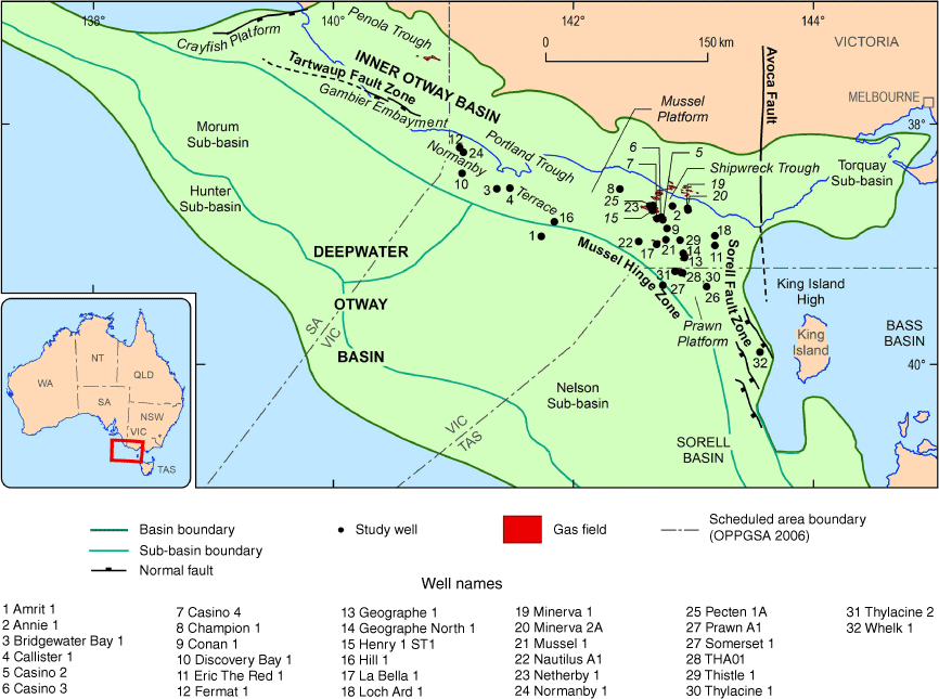
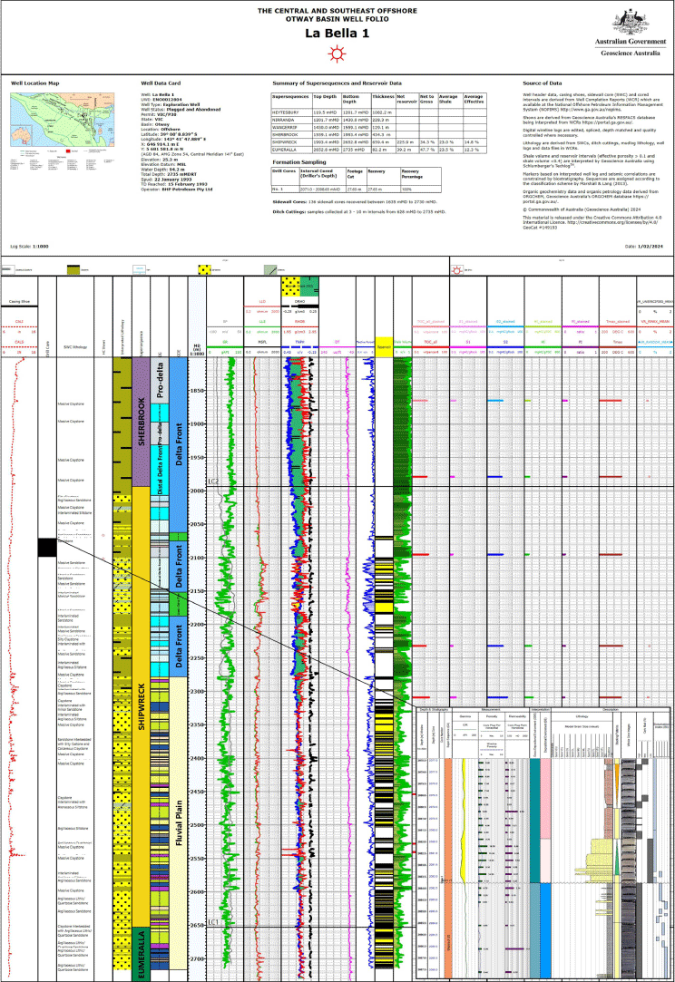
Geoscience Australia (GA) has created the Central and Southeast Offshore Otway Basin Well Folio as an exploration resource. The folio includes 32 wells from the central and southeast parts of the basin and complements the Northwest Offshore Otway Basin Well Folio (Nguyen et al. 2022). The selected wells from the central and southeast offshore region of the Otway Basin (Fig. 1) contribute to GA’s regional seismic interpretation (Nicholson et al. 2022, 2024) and GDE studies (Abbott et al. 2024). The well folio provides well composites (e.g. La Bella 1, Fig. 2) and digital data with updated sequence stratigraphic markers, interpreted lithologies, depositional environment (DE) and gross depositional environment (GDE) intervals, petrophysical interpretation logs, and the integration of historic organic geochemistry and organic petrology results from cuttings, core, and sidewall core samples. In addition, the previously released Northwest Offshore Otway Basin Well Folio has been updated with DE and GDE data (Nguyen et al. 2022).
Well composite for La Bella 1, illustrating data collected and interpreted in this study, including supersequences, well logs, lithology, DEs and GDEs, estimated shale volume and reservoir unit characterisation (using >10% porosity and <40% shale volume cut-off) and organic geochemical data. Complete well composites and data for the studied wells are available in the well folio. The inset figure shows La Bella 1 well core-based DE/GDE log including grain size, lithology assemblages, sedimentary features, bioturbation, well log data and interpretation.
Well data
The interpretation of electric log and sample data for 32 wells in the Central and Southeast Offshore Otway Basin, are presented in this well folio (Table 1). The National Offshore Petroleum Information Management System (NOPIMS) was the main data source. Wireline logs, logging while drilling (LWD) logs, sidewall core and cuttings lithology, and mud logging data were extracted from NOPIMS. Biostratigraphy datasets were obtained from well completion reports (WCRs) and MGPalaeo reports which include the biostratigraphic zonations and laboratory analysis of cuttings and sidewall core samples (MGPalaeo 2020). Organic geochemical data, namely total organic carbon (TOC) content and programmed pyrolysis values, along with organic petrological data, were compiled using WCRs and other publicly available reports.
| Well | Supersequence | Top–bottom (m) | Net reservoir (m) | Net to gross (%) | Average shale volume (%) | Average effective porosity (%) | |
|---|---|---|---|---|---|---|---|
| Amrit 1 | Sherbrook | 2046.3–2979.0 | 10.5 | 1.1 | 28.3 | 25.2 | |
| Annie 1 | Shipwreck | 1685.0–2392.0 | 64.5 | 9.1 | 13.8 | 14.2 | |
| Annie 1 | Eumeralla | 2392.0–2442.0 | 0.0 | ||||
| Bridgewater Bay 1 | Sherbrook | 1200.4–2604.3 | 89.5 | 6.4 | 27.5 | 17.2 | |
| Bridgewater Bay 1 | Shipwreck | 2604.3–4200.0 | 20.0 | 1.3 | 24.8 | 18.7 | |
| Calister 1 | Shipwreck | 2219.7–3869.9 | 20.7 | 1.3 | 23.2 | 11.9 | |
| Calister 1 | Eumeralla | 3869.9–3914.0 | 0.0 | ||||
| Casino 2 | Shipwreck | 1507.9–1981.0 | 54.4 | 11.5 | 17.5 | 16.5 | |
| Casino 3 | Shipwreck | 1860.4–2135.0 | Formation evaluation logs not available | ||||
| Casino 4 | Shipwreck | Not available | 17.5 | Not available | 26.4 | 16.7 | |
| Champion 1 | Sherbrook | 1250.7–1625.0.0 | 65.2 | 17.4 | 18.3 | 22.5 | |
| Champion 1 | Shipwreck | 1625.0–1686.0 | 0.0 | ||||
| Champion 1 | Eumeralla | 1686.0–1882.0 | 4.3 | 2.2 | 35.5 | 12.9 | |
| Conan 1 | Shipwreck | 1649.2–1869.0 | 41.8 | 19.0 | 15.1 | 20.7 | |
| Conan 1 | Eumeralla | 1869.0–1985.0 | 0.0 | ||||
| Discovery Bay 1 | Sherbrook | 1278.8–2745.4 | 556.1 | 37.9 | 16.3 | 23.4 | |
| Discovery Bay 1 | Shipwreck | 2745.4–2775.0 | 4.1 | 13.9 | 12.8 | 13.3 | |
| Eric The Red 1 | Shipwreck | 817.0–1453.9 | 136.7 | 21.5 | 16.0 | 26.2 | |
| Eric The Red 1 | Eumeralla | 1453.9–1875.0 | 191.9 | 45.6 | 21.9 | 15.5 | |
| Fermat 1 | Shipwreck | 1647.3–3585.0 | 54.6 | 2.8 | 10.0 | 12.7 | |
| Geographe 1 | Shipwreck | 1755.2–2430.0 | 246.9 | 36.6 | 13.2 | 17.3 | |
| Geographe North 1 | Shipwreck | 1710.0–2156.0 | 124.8 | 28.0 | 10.7 | 18.8 | |
| Henry 1 ST1 | Sherbrook | 1220.1–1623.6 | 50.1 | 12.4 | 23.7 | 21.3 | |
| Henry 1 ST1 | Shipwreck | 1623.6–1853.1 | 20.6 | 9.0 | 27.1 | 19.0 | |
| Henry 1 ST1 | Eumeralla | 1853.1–2032.0 | 2.1 | 1.2 | 27.4 | 11.1 | |
| Hill 1 | Sherbrook | 1739.4–2576.0 | 7.5 | 0.9 | 31.0 | 24.5 | |
| La Bella 1 | Shipwreck | 1993.4–2652.8 | 255.9 | 34.3 | 23.0 | 14.8 | |
| La Bella 1 | Eumeralla | 2652.8–2735 | 39.2 | 47.7 | 23.5 | 12.3 | |
| Loch Ard 1 | Shipwreck | 536.2–1205.3 | 88.2 | 13.2 | 21.4 | 16.2 | |
| Loch Ard 1 | Eumeralla | 1205.3–1397.0 | 5.9 | 3.1 | 37.0 | 13.8 | |
| Minerva 1 | Shipwreck | 1308.3–2293.1 | 203.5 | 20.7 | 16.5 | 14.0 | |
| Minerva 1 | Eumeralla | 2293.1–2425.0 | 3.4 | 2.5 | 25.6 | 10.4 | |
| Minerva 2A | Shipwreck | 1370.0–2061.3 | 180.9 | 26.2 | 13.6 | 19.1 | |
| Minerva 2A | Eumeralla | 2061.3–2170.0 | 72.6 | 19.5 | 13.9 | 17.2 | |
| Mussel 1 | Shipwreck | 1968.0–2256.1 | 55.6 | 19.3 | 13.6 | 16.8 | |
| Mussel 1 | Eumeralla | 2256.1–2450.0 | 0.0 | ||||
| Nautilus A1 | Wangerrip | 1723.0–1740.4 | 4.88 | 28.0 | 13.8 | 21.6 | |
| Nautilus A1 | Sherbrook | 1740.4–2011.0 | 0.0 | ||||
| Netherby 1 | Sherbrook | 1173.0–1775.5 | 45.3 | 7.5 | 22.7 | 18.9 | |
| Netherby 1 | Shipwreck | 1775.5–1827.5 | 20.6 | 39.6 | 25.2 | 22.6 | |
| Netherby 1 | Eumeralla | 1827.5–1875.0 | 1.1 | 2.2 | 28.9 | 12.8 | |
| Normanby 1 | Shipwreck | 2086.8–3306.0 | 24.4 | 2.0 | 20.3 | 14.9 | |
| Pecten 1A | Sherbrook | 1124.9–1721.8 | 71.9 | 12.1 | 11.7 | 17.9 | |
| Pecten 1A | Shipwreck | 1721.8–1770.0 | 3.8 | 7.9 | 20.2 | 15.1 | |
| Pecten 1A | Eumeralla | 1770.0–2850.5 | 204.8 | 19.0 | 9.1 | 12.2 | |
| Prawn A1 | Sherbrook | 1254.0–1571.7 | 178.5 | 56.2 | 16.9 | 22.5 | |
| Prawn A1 | Shipwreck | 1571.7–2931.1 | 727.3 | 53.5 | 17.8 | 18.0 | |
| Prawn A1 | Eumeralla | 2931.1–3193.0 | 3.5 | 1.23 | 29.7 | 10.5 | |
| Somerset 1 | Shipwreck | 2770.3–2912.0 | 13.3 | 9.4 | 31.1 | 14.5 | |
| THA01 | Shipwreck | 2236.7–2634.0 | 106.0 | 26.7 | 20.5 | 17.4 | |
| Thistle 1 | Shipwreck | 1859.6–2265.0 | 123.1 | 30.4 | 12.0 | 17.6 | |
| Thylacine 1 | Shipwreck | 1990.0–2710.0 | 225.6 | 31.3 | 17.6 | 15.6 | |
| Thylacine 2 | Shipwreck | 2111.5–2525.0 | 140.4 | 34.0 | 17.9 | 14.5 | |
| Whelk 1 | Sherbrook | 713.6–1272.5 | 131.9 | 23.6 | 25.0 | 22.2 | |
| Whelk 1 | Shipwreck | 1272.5–1403.4 | 85.8 | 65.6 | 15.9 | 18.6 | |
| Whelk 1 | Basement | 1403.4–1466.0 | 50.1 | 80.2 | 0.6 | 26.6 | |
Well log interpretation
Wireline log data were the main inputs for the petrophysical analysis. The primary data were calliper (CAL), gamma ray (GR), spontaneous potential (SP), resistivity (shallow, medium and deep resistivity logs), sonic (DT), density correction (DRHO), density (RHOB), and neutron porosity (TNPH). Schlumberger’s Techlog™ was used to perform petrophysical analyses and to create the well composites. GR logs were primarily used to determine the shale volume (Vshale). Clean sand and shale points were picked based on GR values together with other data, where available, such as density-neutron cross plot and SP and lithology facies. Effective porosity estimates were analysed from RHOB, TNPH and DT, and Vshale correction. These estimates were compared with laboratory core porosity measurements, where available, to select the best porosity method in each well. Net reservoir properties, including average shale volume and average effective porosity summaries were estimated for the deeper supersequences in each well (Table 1). The net reservoir cut-off assumptions are shale volume <40% and effective porosity >10% for all wells.
Sandstone reservoirs within the Shipwreck Supersequence were the main targets in most of the studied wells. Except for Champion 1 that has no net reservoir, petrophysical analysis in wells that intersect the Shipwreck Supersequence show that the predominant lithologies are thick interbedded sandstone, siltstone and claystone, where some individual sandstone beds are more than 10 m thick. In most wells, shale volume ranges from 13 to 25% and average effective porosity ranges from 14 to 19% in the Shipwreck Supersequence.
Petroleum systems
Of the three Austral petroleum systems (Edwards et al. 1999; Boreham et al. 2004), the Austral 3 (Upper Cretaceous to lowest Cenozoic fluvial-deltaic and marine facies mostly within the Shipwreck and Sherbrook supersequences) are considered the most prospective source rocks in deep-water areas (Schenk et al. 2023) rather than those of the Lower Cretaceous Austral 2 Petroleum System. The well folio displays pyrolysis data for each well to draw attention to any organic-rich units and vitrinite reflectance data is provided as a measure of thermal maturity (Fig. 2). In some wells, these data may show anomalously high S1, high production index (PI) and low Tmax values indicating that these samples are affected by the presence of free hydrocarbons, typically derived from drilling additives. Anomalous results are indicated by paler coloured bars on the well composites.
Depositional environment interpretation
Depositional environment (DE) and gross depositional environment (GDE) interval interpretations are presented in the well folio relative to wireline and core datasets (where available). For each well, these intervals extend from TD (typically Shipwreck/Eumeralla Supersequence) to base-Cenozoic (T1) and were interpreted using all available well data, with 917 m of core being used as interpretation anchor points in 19 wells. Standardised DE/GDE interpretations were compiled from 407 m of core described in this study along with 510 m of core described by other authors.
DEs were defined as packages of sediment that formed in specific geological conditions (e.g. braided fluvial channel or marine lower shoreface environments). These packages of sediment typically have varied lithology types and DE interpretations are assigned according to a set of criteria which include grain size trends, lithology assemblages, sedimentary features, bioturbation, as well as depositional package juxtaposition and regional context. DE interpretations were made for all cores and depth matched to wireline and core plug datasets (Cubitt et al. 2024). Similar DEs were grouped to form seismic scale GDE intervals. An example of this process is shown in Fig. 2 where pro-delta, distal delta and proximal delta front DE intervals have been grouped together as a ‘delta front GDE’.
Core-based DE and GDE intervals were linked to wireline log signatures. DE and GDE well signatures were defined over all cored intervals in the 19 control wells and then extrapolated to neighbouring (non-cored) wells using a visual like-for-like process (Abbott et al. 2023; Cubitt et al. 2023) with interpretations made relative to biostratigraphic and seismic facies contexts. The DE/GDE interpretations informed the refinement of well marker picks, leading to refinements in regional correlation.
Summary and conclusions
The Central and Southeast Offshore Otway Basin Well Folio together with the previously released Northern Offshore Otway Well Folio are resources intended for the assessment of hydrocarbon prospectivity across the offshore Otway Basin. The new sequence picks and understanding of the lithologies, reservoir properties and core-controlled DE/GDE intervals across the basin will provide valuable input into constraining regional mapping. The folio provides well composite logs of organic geochemical data, sequence stratigraphy and petrophysical evaluations that form the basis for further studies into source rock potential and reservoir and seal quality in the offshore Otway Basin.
Data availability
The data that support this study are available in the National Offshore Petroleum Information Management System (NOPIMS) at http://www.ga.gov.au/nopims. The well core-based DE/GDE study, including detailed core logging data is downloadable at http://pid.geoscience.gov.au/dataset/ga/149190. The well folio data package is downloadable at http://pid.geoscience.gov.au/dataset/ga/149358
Conflicts of interest
No conflicts of interest exist between the authors and any other person or organisation.
Acknowledgements
We would like to thank Tamara Buckler, Minerals, Energy and Groundwater Information Services for data management. Liuqi Wang and Emmanuelle Grosjean are thanked for their constructive reviews. This abstract is published with the permission of the CEO, Geoscience Australia.
References
Abbott S, Cubitt C, Bernardel G, Nicholson C, Nguyen D (2023) Towards a regional understanding of Sherbrook Supersequence Gross Depositional Environments, offshore Otway Basin. In ‘Australasian Exploration Geoscience Conference Proceedings’, 13–18 March 2023, Brisbane, Qld. 10.5281/zenodo.7980133
Abbott S, Cubitt C, Bernardel G, Nicholson C, Nguyen D (2024) Shipwreck and Sherbrook Supersequence Regional Gross Depositional Environments, offshore Otway Basin. Australian Energy Producers Journal 64, S302-S307.
| Crossref | Google Scholar |
Boreham CJ, Hope JM, Jackson P, Davenport R, Earl KL, Edwards D, Logan GA, Krassay AA (2004) Gas–oil–source correlations in the Otway Basin, southern Australia. In ‘Eastern Australasian Basins Symposium II’. (Eds PJ Boult, DR Johns, SC Lang) pp. 603–627. (Petroleum Exploration Society of Australia, Special Publication: Adelaide) Available at https://pesa.com.au/pesas_eastern_australasian_basin_symposium_ii_p603-627-pdf/
Cubitt C, Abbott S, Bernardel G, Gunning M-E, Nguyen D, Nicholson C, Stoate A (2023) Cretaceous depositional environment interpretation of offshore Otway Basin cores and wireline logs; application to the generation of basin-scale gross depositional environment maps. The APPEA Journal 63, S215-S220.
| Crossref | Google Scholar |
Cubitt C, Nguyen D, Nicholson C, Stoate A (2024) ‘Offshore Otway Basin Core logs [metadata statement and digital data package]’. Geoscience Australia eCAT#149190. (Commonwealth of Australia: Canberra) 10.26186/149190
Edwards DS, Struckmeyer HIM, Bradshaw MT, Skinner JE (1999) Geochemical characteristics of Australia’s southern margin petroleum systems. The APPEA Journal 39(1), 297-321.
| Crossref | Google Scholar |
Krassay A, Cathro D, Ryan D (2004) A regional tectonostratigraphic framework for the Otway Basin. In ‘Eastern Australasian Basins Symposium II’. (Eds PJ Boult, DR Johns, SC Lang) pp. 97–116. (Petroleum Exploration Society of Australia: Adelaide) Available at https://pesa.com.au/pesas_eastern_australasian_basin_symposium_ii_p97-116-pdf/
MGPalaeo (2020) Palynological summary sheets. Available at https://www.mgpalaeo.com.au/otway-basin/ [viewed 22 January 2024]
Nguyen D, Edwards DS, Gunning M-E, Bernadel G (2022) ‘The Northwest Offshore Otway Basin Well Folio [metadata statement and updated digital data package]’. Geoscience Australia eCAT#146429. (Commonwealth of Australia: Canberra) 10.26186/146429
Nguyen D, Cubitt C, Edwards D, Abbott S, Bernardel G (2024) The central and southeast offshore Otway Basin well folio (metadata statement and digital data package). Geoscience Australia, Canberra. Available at http://pid.geoscience.gov.au/dataset/ga/149358
Nicholson C, Abbott S, Bernardel G, Gunning M-E (2022) Stratigraphic and structural architecture of the Upper Cretaceous in the deep-water Otway Basin-implications for frontier hydrocarbon prospectivity. The APPEA Journal 62, S467-S473.
| Crossref | Google Scholar |
Nicholson C, Abbott S, Bernardel G, Poudjom Djomani Y (2024) A new perspective on regional structural architecture across the offshore Otway Basin. Australian Energy Producers Journal 64, S416-S422.
| Crossref | Google Scholar |
Schenk O, Grosjean E, Edwards DS, Boreham CJ, West T, Karvelas A, Kornpihl D (2023) Petroleum system modelling of the deep-water Otway Basin. In ‘4th AEGC: Geoscience-Breaking New Ground’, 13–18 March 2023, Brisbane Convention and Exhibition Centre. Extended Abstracts. (Australian Society of Exploration Geophysicists) 10.5281/zenodo.7980139
Duy (Victor) Nguyen is a petroleum engineer at Geoscience Australia. Duy has oil and gas industrial experience working in Australia, Asia and Africa. Duy joined Geoscience Australia in 2009 and is working as a Well Analyst on Australia’s offshore basins. |
Chris Cubitt has more than two decades of industry experience in reservoir and regional geology working basins worldwide. He is a Team Leader of Basin Prospectivity at Geological Survey of South Australia. |
Dianne Edwards is a senior petroleum geochemist in at Geoscience Australia’s Basin Systems Branch, Minerals, Energy and Groundwater Division. Her scientific focus is on defining the petroleum systems of Australia’s basins. She was awarded her PhD from the University of Adelaide in 1996. |
Steve Abbott holds a PhD degree in sedimentary geology from James Cook University. He joined Geoscience Australia in 2013 where he works as a Basin Analyst on regional tectonic and stratigraphic studies of Australia’s offshore basins. |
George Bernardel is a geoscientist at Geoscience Australia. He gained his BSc (Honours) in Geophysics from the University of Sydney in 1986 and joined Geoscience Australia in 1995. His current role is the seismic mapping of Cretaceous–Cenozoic sequences and structure across the offshore Otway Basin. |