

A new perspective on regional structural architecture across the offshore Otway Basin
Chris Nicholson A * , Steve Abbott A , George Bernardel A and Yvette Poudjom Djomani AA

Chris Nicholson graduated with a BSc (Hons) in Geology from the Australian National University in 2000. He joined Geoscience Australia in 2004 as Basin Analyst and Structural Geologist working on regional prospectivity studies of Australia’s offshore basins. Chris is a member of PESA and SEAPEX, and is a past president of PESA ACT. |

Steve Abbott holds a PhD degree in sedimentary geology from James Cook University. He joined Geoscience Australia in 2013 where he works as a Basin Analyst on regional studies of Australia’s offshore basins. Steve is a member of PESA and SEPM, and is past president of PESA ACT. |

George Bernardel gained his BSc (Honours) in Geophysics from the University of Sydney in 1986. He joined Geoscience Australia in 1995 where he works as a Basin Analyst on Australia’s offshore basins. He is currently mapping Cretaceous–Cenozoic sequences and structure across the offshore Otway Basin. |

Yvette Poudjom Djomani completed a PhD in geophysics at the University of Paris XI (France) and earned an MBA from the Australian Institute of Business (Adelaide). She joined Geoscience Australia in 2016 where she works as a Potential Field Geophysicist. Yvette is currently working on depth to basement modelling of the Deep-water Otway Basin. She is a member and Treasurer of ASE. |
Abstract
Geoscience Australia has undertaken a regional seismic mapping study of the offshore Otway Basin extending across the explored inner basin to the frontier deep-water region. Seismic interpretation covers over 18,000 line-km of new and reprocessed data acquired in the 2020 Otway Basin seismic program and over 40,000 line-km of legacy 2D seismic data. We present new basin-scale isochore maps that show the distribution of the Cretaceous depocentres. Maps for the Lower Cretaceous Crayfish and Eumeralla supersequences, together with those recently published for the Upper Cretaceous Shipwreck and Sherbrook supersequences, complete the set of isochore maps for the main tectonostratigraphic basin intervals. Mapping of basement-involved faults has revealed structural fabrics that have influenced depocentre development. The tectonostratigraphic development of depocentres and maps of deep crustal units delineate crustal thinning trends related to late Cretaceous extension phases. This work highlights the need to review and update structural elements. For example, the boundary between the Otway and Sorell basins is now geologically constrained. The refinements to the tectonostratigraphic evolution of the Otway Basin presented here have important implications for the distribution and potential maturity of petroleum systems, especially with regard to heat flow associated with crustal extension.
Keywords: basement, basin boundaries, Eumeralla Supersequence, Otway Basin, reflection MOHO, Sherbrook Supersequence, Shipwreck Supersequence, structural architecture, top lower laminated crust.
Introduction
The Otway Basin (Fig. 1) formed during the rifting of Australia from Antarctica and contains an Upper Jurassic to Cenozoic sedimentary succession that consists of unconformity-bound seismic supersequences (Krassay et al. 2004). Geological understanding of the deep-water region was previously limited by sparse seismic data coverage but has been improved by recent acquisition and reprocessing. The 2020 Otway Basin 2D seismic program included acquisition of over 7000 line-km of 2D seismic, gravity and magnetic data, together with reprocessing of over 10,000 line-km of legacy 2D data. The 2023 Otway 3D post-stack Mega Merge seismic dataset (Gunning et al. 2024) has increased the confidence of mapping between the deep-water and inner Otway Basin. Revisions to the stratigraphic framework and structural architecture for the Upper Cretaceous Shipwreck and Sherbrook supersequences have recently been published (Nicholson et al. 2022). New work presented here includes interpretations of the Lower Cretaceous Crayfish (latest Jurassic-Barremian) and Eumeralla (Aptian-Albian) supersequences, basement, basement-involved faults, reflection MOHO (Mohorovičić discontinuity), and the top of lower laminated continental crust (TLLCC). Results highlight the distribution of Lower Cretaceous depocentres, the basin and basement structural architecture, and crustal thinning trends across the inner and deep-water Otway Basin extending to the outer margin highs (Fig. 2).
(a) Structural elements map of the Otway Basin showing the 2020 new and reprocessed seismic data, legacy 2D seismic data, petroleum wells and fields, the locations of Fig. 3 seismic transects and updated and previous basin boundaries. (b) Updated basin boundaries, basement-involved faults, fold axes and outer margin high outlines overlying the Cretaceous (latest Jurassic-base Cenozoic) depocentre isochore map.

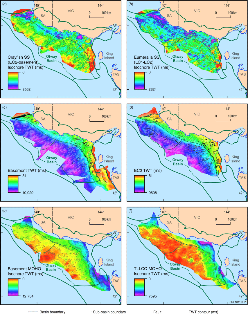
Seismic horizon structure and isochore maps of the offshore Otway Basin Lower Cretaceous interval and deep crustal reflectors. Faults intersecting structure surfaces are marked in black. (a) Crayfish Supersequence isochore map (EC2-Basement). (b) Eumeralla Supersequence isochore map (LC1-EC2). (c) Basement structure surface (d). EC2 (base Aptian-Albian Eumeralla Supersequence) structure surface. (e) Basement to Mohorovičić discontinuity (MOHO) isochore map. (f) top of lower laminated continental crust (TLLCC) to MOHO seismic isochore map.
Cretaceous depocentre
The Cretaceous depocentre (Fig. 1b) is based on interpretation of the base Wangerrip Supersequence (base Cenozoic) breakup unconformity (T1) and the top basement surface (base Crayfish Supersequence) (Fig. 3) across the offshore Otway Basin. The depocentre attains a maximum thickness of ~5800 ms two-way time (TWT) in the Morum Sub-basin and the northwestern part of the Nelson Sub-basin. On the outboard margin of the basin, the depocentre thins as Upper Cretaceous sediments onlap a series of outer margin highs (Figs 1b, 3b). The southeast margin of the Cretaceous depocentre is marked by a series of half graben that formed over shallow basement across the Sorell Fault Zone. In the northwest, a series of small half graben step up from the Morum Sub-basin onto the Crayfish Platform and abut the Trumpet Fault and basement high (Fig. 1). The Upper Cretaceous Shipwreck and Sherbrook supersequences have been documented elsewhere (Nicholson et al. 2022). The Lower Cretaceous sequences are summarised in the following.
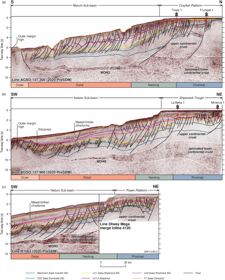
Seismic stratigraphy and structure interpretation of the Cretaceous and deep crustal reflectors on representative seismic profiles across the offshore Otway Basin. Proximal, Necking, Distal and Outer structural domains illustrate progressive crustal thinning outboard, corresponding with thickening of Cretaceous sediments. See Fig. 1 for locations. (a) Dip line from the Crayfish Platform to the Morum Sub-basin. (b) Dip line from the Shipwreck Trough to the Nelson Sub-basin. (c) Dip line from the Prawn Platform to the Nelson Sub-basin.
Crayfish Supersequence
Unconformably overlying Paleozoic basement, the Crayfish Supersequence (Fig. 2a, latest Jurassic-Barremian) is a fluvio-lacustrine succession, representing the initial extension phase in the basin. The supersequence is thickest in half graben depocentres across platform areas on the inner Otway Basin (Figs 1a, 2a). In the deep-water region, the supersequence is relatively thin. On the far southeastern and northwestern basin margins, it is thin to absent over basement highs. It is also thin or absent to the southwest towards the outer margin highs (Figs 1b, 2a).
Eumeralla Supersequence
The Eumeralla Supersequence (Fig. 2b, Aptian-Albian) is a volcaniclastic sag succession, broadly isopachous in outboard areas, bound at its base by the Early Cretaceous 2 unconformity (EC2, Pilosisporites notensis spore-pollen zone) and above by the Late Cretaceous 1 unconformity (LC1, base Phyllocladidites mawsonii spore-pollen zone). Maximum thicknesses occurs where it overlies synrift depocentres on the Crayfish Platform, Normanby Terrace, Portland Trough and Shipwreck Trough (Figs 1a, 2b). The supersequence thins across the inner Otway Basin south into the Morum and Nelson sub-basins.
Crustal architecture
Basement architecture is broadly aligned with structural geometries observed in the Cretaceous depocentre. In the southeast, a dominant NNW–SSE basement grain controls faulting, basement features, and basin architecture (Gibson et al. 2011). An associated series of NNW-SSE oriented basement-involved faults from the Sorell Fault Zone defines the Otway and northeastern Sorell basin boundaries (Figs 1a, b, 2c). Further outboard along the Mussel Hinge Zone, a series of en échelon, NNW–SSE to NW–SE oriented, crustal-scale detachment faults, step down from the platform edge and offset basement (Figs 1b, 2c, 3b, c). Across the Prawn Platform, Shipwreck Trough and Mussel Platform, basement faults predominantly trend between NE–SW and N–S and are commonly aligned with Cretaceous fold axes (Fig. 1a, b), indicating that deformation was basement-controlled. In the northwest, the ENE–WSW oriented Trumpet Fault (Fig. 1a) marks the basin boundary. It is accompanied by a series of E–W oriented faults that offset basement to the south (Figs 2c, 3a). The EC2 unconformity (Fig. 2d) broadly follows the structural architecture of the underlying basement surface (Fig. 2c). However, it also inherits the largely NW–SE oriented fault architecture of an overlying Late Cretaceous synrift succession from the Shipwreck Supersequence (Nicholson et al. 2022).
The top of lower laminated continental crust (TLLCC) and Mohorovičić discontinuity (MOHO) seismic picks were constrained by a package with distinctly layered seismic facies (Fig. 3). This reveals a zone of crustal thinning that is clearly imaged by the Basement-MOHO and TLLCC-MOHO isochores (Fig. 2e, f). The laminated lower continental crust and combined upper and lower crust are thickest beneath the inner Otway Basin (Figs 2e, f, 3) and thin outboard across the deep-water Otway Basin.
Discussion
Cretaceous crustal thinning and depocentre development
Interpreted seismic sections and the basement-MOHO and TLLCC-MOHO isochore maps reveal a zone of major crustal thinning extending from the inner Otway Basin to deep-water areas (Figs 2e, f, 3). These data delineate proximal, necking, distal and outer structural domains across the margin (Fig. 3), correlating with varying degrees of crustal stretching (Peron-Pinvidic 2022). This relationship has been previously recognised in the Otway Basin, but interpretations of new seismic data have enabled it to be mapped regionally and illustrate the highly extended nature of crust in the deep-water Otway Basin (Fig. 2e, f). The isochore maps show a strong relationship between the areas of thinned continental crust and the location of Late Cretaceous extensional depocentres in the Morum and Nelson sub-basins (Fig. 2e, f; Nicholson et al. 2022), indicating that the bulk of crustal thinning was associated with this second phase of extension. The lower laminated continental crust is thinnest below the outboard Shipwreck and Sherbrook supersequence depocentres (Fig. 2f; Nicholson et al. 2022), and likely influencing their location (Moore et al. 2000). In addition, the zone of crustal thinning also appears to have influenced the distribution of recently mapped Shipwreck and Sherbrook supersequence regional gross depositional environments (Abbott et al. 2024) and therefore has implications for the development and preservation of potential petroleum system elements. In contrast, Crayfish rift and Eumeralla sag depocentres overlie relatively thick crust in the inner Otway Basin and were less influenced by crustal thinning (Fig. 2a, b).
It is likely the intense Late Cretaceous crustal extension would have favoured elevated heat flow. This may have had detrimental implications for source rocks within the Shipwreck Supersequence, modelled to be highly mature in deep-water areas (Schenk et al. 2021). Conversely, it could have resulted in hydrocarbon generation from shallower marine source rocks in the Sherbrook Supersequence (Abbott et al. 2024) over areas of highly extended continental crust.
Basin boundary revisions
Maps presented here highlight the need to update the structural elements and boundaries for the Otway Basin, and in particular the Otway–Sorell basin boundary (Fig. 1a). This boundary was previously arbitrary in nature, as the legacy seismic coverage did not support a geological boundary (Moore et al. 2000). However, using the Cretaceous isochore map (Fig. 1b), delineation of a geologically meaningful boundary between Otway and Sorell basins is now possible. The revised boundary separates the different depositional systems of the Otway and Sorell basins which has important implications for the potential development, distribution, and preservation of petroleum system elements such as reservoir and seal lithologies. Further, seismic, gravity and magnetic data have enabled a revision of the outboard Otway Basin boundary, with the Cretaceous depocentre extending further outboard than previously mapped (Figs 1b, 3a, b). Additionally, it can be demonstrated that the Discovery Bay High (Moore et al. 2000), is not a recognisable feature in the deep-water Otway Basin (Figs 1b, 2a–d; Nicholson et al. 2022). This structural element has instead been replaced with a boundary that delineates the Morum and Nelson sub-basins.
Conclusions
Work presented here clarifies the distribution of the Cretaceous depocentre, and component supersequence depocentres of the offshore Otway Basin. The distribution of Lower Cretaceous depocentres and structural elements along the inner Otway Basin and outboard trends in crustal thinning and rifting during the Late Cretaceous have important implications for the distribution and potential maturity of petroleum systems. This work also highlights the need to review and update structural elements. For example, the boundary between the Otway and Sorell basins is now geologically constrained. The separation of the Otway and Sorell depocentres as distinct tectonostratigraphic entities may have important implications for their petroleum systems characteristics.
Data availability
The data that support this study are available in the National Offshore Petroleum Information Management System (NOPIMS) at http://www.ga.gov.au/nopims.
Acknowledgements
Barry Bradshaw and Tom Bernecker reviewed the draft manuscript. Ethan Shaw prepared the figures. This abstract is published with the permission of the CEO, Geoscience Australia.
References
Abbott S, Cubitt C, Bernardel G, Nicholson C, Nguyen D (2024) Shipwreck and Sherbrook Supersequence Regional Gross Depositional Environments, offshore Otway Basin. Australian Energy Producers Journal 64, S302-S307.
| Crossref | Google Scholar |
Gibson GM, Morse MP, Ireland TR, Nayak GK (2011) Arc–continent collision and orogenesis in western Tasmanides: Insights from reactivated basement structures and formation of an ocean–continent transform boundary off western Tasmania. Gondwana Research 19, 608-627.
| Crossref | Google Scholar |
Gunning M, Wilkinson S, Chau P, Mitchell C, Badry J (2024) Post-stack 3D merging to fast-track regional interpretation - offshore Otway Basin case study. Australian Energy Producers Journal 64, S388-S392.
| Crossref | Google Scholar |
Moore AMG, Stagg HMJ, Norvick MS (2000) Deep-water Otway Basin: A new assessment of the tectonics and hydrocarbon prospectivity. The APPEA Journal 40, 66-84.
| Crossref | Google Scholar |
Nicholson C, Abbott S, Bernardel G, Gunning ME (2022) Stratigraphic framework and structural architecture of the Upper Cretaceous in the deep-water Otway Basin – implications for frontier hydrocarbon prospectivity. The APPEA Journal 62, S467-S473.
| Crossref | Google Scholar |
Peron-Pinvidic G (2022) The seismic reflection Moho across the mid-Norwegian continental rifted margin. Communications Earth & Environment 3, 133.
| Crossref | Google Scholar |
Schenk O, Karvelas A, West T, Kornpihl D (2021) Otway Basin Regional Study report. Available at https://www.ga.gov.au/nopims/releases/otway-basin-regional-study-report
Chris Nicholson graduated with a BSc (Hons) in Geology from the Australian National University in 2000. He joined Geoscience Australia in 2004 as Basin Analyst and Structural Geologist working on regional prospectivity studies of Australia’s offshore basins. Chris is a member of PESA and SEAPEX, and is a past president of PESA ACT. |
Steve Abbott holds a PhD degree in sedimentary geology from James Cook University. He joined Geoscience Australia in 2013 where he works as a Basin Analyst on regional studies of Australia’s offshore basins. Steve is a member of PESA and SEPM, and is past president of PESA ACT. |
George Bernardel gained his BSc (Honours) in Geophysics from the University of Sydney in 1986. He joined Geoscience Australia in 1995 where he works as a Basin Analyst on Australia’s offshore basins. He is currently mapping Cretaceous–Cenozoic sequences and structure across the offshore Otway Basin. |
Yvette Poudjom Djomani completed a PhD in geophysics at the University of Paris XI (France) and earned an MBA from the Australian Institute of Business (Adelaide). She joined Geoscience Australia in 2016 where she works as a Potential Field Geophysicist. Yvette is currently working on depth to basement modelling of the Deep-water Otway Basin. She is a member and Treasurer of ASE. |