

A preliminary assessment of regional CO2 storage potential in the onshore northern Perth Basin
Louisa Ellis A , Charmaine Thomas A , Julie Cass A , Arthur Mory A and Deidre Brooks A *A

Louisa Ellis obtained a BSc (Hons) in Geology (University of Western Australia) in 2001. After a stint in mining, she made the switch to the petroleum industry in 2004, commencing work at Woodside, Perth, where she remained for 15 years. Louisa worked within various teams across exploration and development within Woodside, with her most recent role being 3 years spent in petroleum systems modelling. She joined DEMIRS in 2021 in the position of Senior Geologist within the Energy and Geoscience branch, where she is primarily involved in the creation of an atlas of CO2 storage prospectivity within Western Australia. |

Charmaine Thomas is Senior Geoscientist in the Energy Geoscience and Carbon Strategy Group at the Geological Survey of Western Australia. Her main interests are basin analysis and tectonics, and seismic interpretation. She received a B.Sc. (Hons) from the University of Western Australia in 2006, before joining Woodside Energy as a graduate Geologist in 2007. In 2012, she completed her M.Sc. thesis on the numerical modelling of rift basin initiation and evolution at the University of Sydney. Charmaine is a member of PESA and GSA. |

Julie Cass is a petrophysicist with over 20 years international experience in the oil and gas industry. She currently works for the Geological Survey and Resource Strategy Division of the Department of Mines, Industry, Regulation and Safety. Before joining the survey Julie worked for Chevron Australia in Perth, Marathon Oil and Helix RDS in the UK, and Santos in Brisbane; moving between petrophysical specialist and multidisciplinary project-based leadership positions. Julie has worked on a diverse range of assets, in many countries, across many depositional settings and fluid types. She has experience using a wide variety of log and core based petrophysical evaluation methodologies to produce reliable static, dynamic and rock physics assessments to develop an understanding of reservoir quality controls and evaluate uncertainty. Julie has a Bachelor of Science (Applied Geology) and a Master’s degree in Engineering Science (Petroleum Engineering) from Curtin University. She is a member of PESA, SPWLA and SPE. |

Arthur Mory has been with the provincial Geological Survey of Western Australia for aeons, but still enjoys his role as a churlish curmudgeon. |

Deidre Brooks has been the Manager Energy Geoscience at the GSWA since 2016. Prior to this Deidre worked for over 35 years as a petroleum geologist in technical and leadership roles at Esso, Santos, BHP Petroleum, Woodside and Origin Energy. The work at GSWA has expanded Deidre’s horizons from focussing on petroleum to new and alternative energy-related geosciences such as natural hydrogen, helium, geothermal and CO2 sequestration. |
Abstract
The Geological Survey of Western Australia (GSWA) is creating a new carbon dioxide (CO2) geological storage atlas for Western Australia. The atlas will incorporate the latest state-wide datasets to provide a regional assessment of the potential for CO2 sequestration across the Perth, Southern Carnarvon, Northern Carnarvon (onshore and State waters), Canning and Officer basins. Multi-1D modelling of subsurface temperature in the northern Perth Basin incorporates newly collated temperature data, updated regional depth maps, and stratigraphic revisions. This modelling captures lateral subsurface temperature variations that are incorporated into isothermal depth and temperature maps identifying reservoir units within the optimum temperature–pressure window for CO2 storage. Isopach maps of associated sealing units indicate where they are of adequate thickness to contain CO2. Modelled present-day temperature maps of seven key reservoir units reveal promising CO2 storage prospectivity, with all postulated reservoir units having significant extents within optimum CO2 storage temperature and pressure ranges. Whereas older reservoir units are prospective for CO2 storage towards the margins of the basin, younger reservoir units in the shallower part of the succession are only prospective in or near the Dandaragan Trough, the deepest part of the basin. The critical upper temperature limit of 31.1°C is shallower in the north and west of the basin, where the modelled geothermal gradient is higher. All state-wide raw and interpreted datasets including temperature and depth maps will be published and available for download on the GSWA Western Australian Petroleum and Geothermal Information Management System website.
Keywords: AI, borehole temperature data, CO2, LAS files, multi-1D temperature modelling, new geoscience data, new interpretations, northern Perth Basin, Python code, regional assessment, regional depth maps, sequestration, storage, stratigraphic revisions.
Introduction
A new carbon dioxide (CO2) geological storage atlas for Western Australia being prepared by the Geological Survey of Western Australia (GSWA) expands the scope of the previous version by 3D-GEO Pty Ltd (2013) to include the State waters of the Northern Carnarvon Basin and the Officer Basin, with updated regional interpretations of the sequestration potential and a focus on providing relevant state-wide datasets. Funded by the Western Australian Ministerial Taskforce on Climate Action, this initiative is aligned with the government’s commitment to establishing a framework for CO2 sequestration. The project commenced on 1 July 2022 and is ongoing, although initial funding finishes on 30 June 2024.
Building upon the approach set out in National Energy Technology Laboratory (2017), Halland et al. (2014), and Bradshaw et al. (2007), the atlas is focussed on critical temperature and pressure, storage capacity and containment criteria essential for assessing the potential for permanent CO2 sequestration. To follow this approach the atlas includes state-wide datasets of borehole temperature, well log data, routine core analyses, biostratigraphy and seismic data.
Formation temperature and pressure play a crucial role in screening and defining formations suitable for CO2 storage as a supercritical fluid. The critical temperature and pressure required for CO2 to stabilise as a supercritical fluid are generally assumed to be 31.1°C and 10730 psi (Span and Wagner 1996). These conditions are usually met at depths around 800 m below ground level in hydrostatic conditions, but this may vary with geothermal gradient (Bachu 2000, 2002). Our multi-1D modelling of subsurface temperature in the northern Perth Basin incorporates newly collated temperature data, updated regional depth maps, and stratigraphic revisions. This modelling captures lateral temperature variations and enables the creation of temperature maps to identify reservoir units that may fall within the optimum CO2 temperature–pressure window. Where reservoirs are modelled to fall within this window, isopach maps of associated seal units further highlight prospectivity by indicating where they are of adequate thickness (>50 m, but preferably >200 m), to provide a satisfactory means of containment.
Data availability
Borehole temperature data were collated from open-file reports for 186 wells in the northern Perth Basin. Temperature data contains contextual information required for interpretation, including time since circulation and means of acquisition. Seventy-two wells with bottom-hole temperature (BHT) data from wireline logs have been corrected for the cooling effects of circulating borehole fluids using statistical methods outlined in Beardsmore and Cull (2001), and another 18 have drill stem test (DST) temperature data. Corrected BHT data along with DST temperature data from 35 wells were utilised in the 1D temperature modelling. These temperature data types are likely to provide the best estimates of the true formation temperature (Beardsmore and Cull 2001).
Open-file LAS (Log ASCII standard) files from northern Perth Basin wells have been wrangled via Python code into a unified format with consistent depth references, mnemonics, units, x, y, z coordinates and well names suitable for AI-based analysis. Previously compiled routine core analyses have undergone quality control checks and been reformatted to enhance data accessibility. These datasets have been used to update formation tops and will contribute to reservoir quality assessments.
Depth maps used in the modelling were produced by re-interpreting seismic data and collating existing open-file maps. As part of the mapping process, well velocity survey data have been updated and formation tops revised using biostratigraphic data. As they become available, all datasets will be published via Western Australian Petroleum and Geothermal Information Management System (WAPIMS, https://wapims.dmp.wa.gov.au/wapims) on the Department’s website.
Onshore northern Perth Basin temperature modelling
One-dimensional subsurface temperature models were built for 57 key locations across the northern Perth Basin. These models incorporate well formation tops or were extracted from regional depth maps down to the basement for unpenetrated sections in areas with insufficient well control. Lithologies for each formation in each model are from cuttings or descriptions in well completion reports. The transient heat-flow model uses a fixed temperature of 1330°C at base lithosphere as the bottom boundary condition, and surface temperature as the top boundary condition. Individual 1D models were calibrated to measured borehole temperatures using variable crustal thickness and radiogenic heat production. Heat flow at base sediment section was then calculated, with predictions away from well control based on differences in crustal and sediment thickness, sedimentation rates and lithology (thermal conductivity).
A regional heat flow model for the northern Perth Basin was generated from the 57 1D well models using Zetaware software. Temperature and isothermal depth maps for seven key reservoir horizons were created from the calibrated regional temperature model and newly assembled regional depth maps.
Results
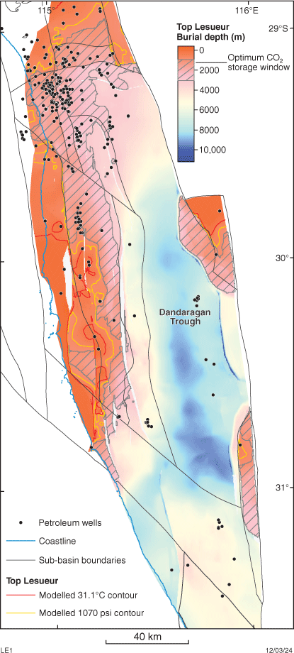
Present-day temperature maps have been created for the following stratigraphic horizons: Top Cadda, Top Cattamarra, Top Lesueur, Top Woodada, Top Dongara/Wagina/Beekeeper, Top Irwin River, and Top Kingia/High Cliff. As an example, a burial depth map of the Top Lesueur (Fig. 1) indicates where this horizon lies between 1000 and 3000 m below ground level. The red contour signifies where the top of the Lesueur Sandstone reaches 31.1°C in the model, whereas the yellow contour indicates where it reaches 1070 psi (assuming hydrostatic conditions). These contours and the temperature map (Fig. 2a) show that the Top Lesueur aligns with the critical temperature–pressure window for CO2 storage over an extensive area within the basin. By comparison, the Lesueur Sandstone is too shallow for CO2 storage along the northern and western edges of the basin. Conversely, in the central part of the basin, the formation is deeper than 3000 m, warranting further investigation into reservoir controls on its CO2 storage capacity.
Top Lesueur depth map (metres below ground level), showing the optimum temperature (°C), pressure (psi, hydrostatic conditions) and burial depths (m) for CO2 storage.
(a) Top Lesueur modelled temperature (°C) map showing optimum temperature (modelled), pressure (hydrostatic) and mapped burial depth contours for CO2 storage; (b) isothermal depth map showing that the critical temperature limit of 31.1°C is modelled at shallower depths in the north and north-west of the basin, where the geothermal gradient is estimated to be higher.
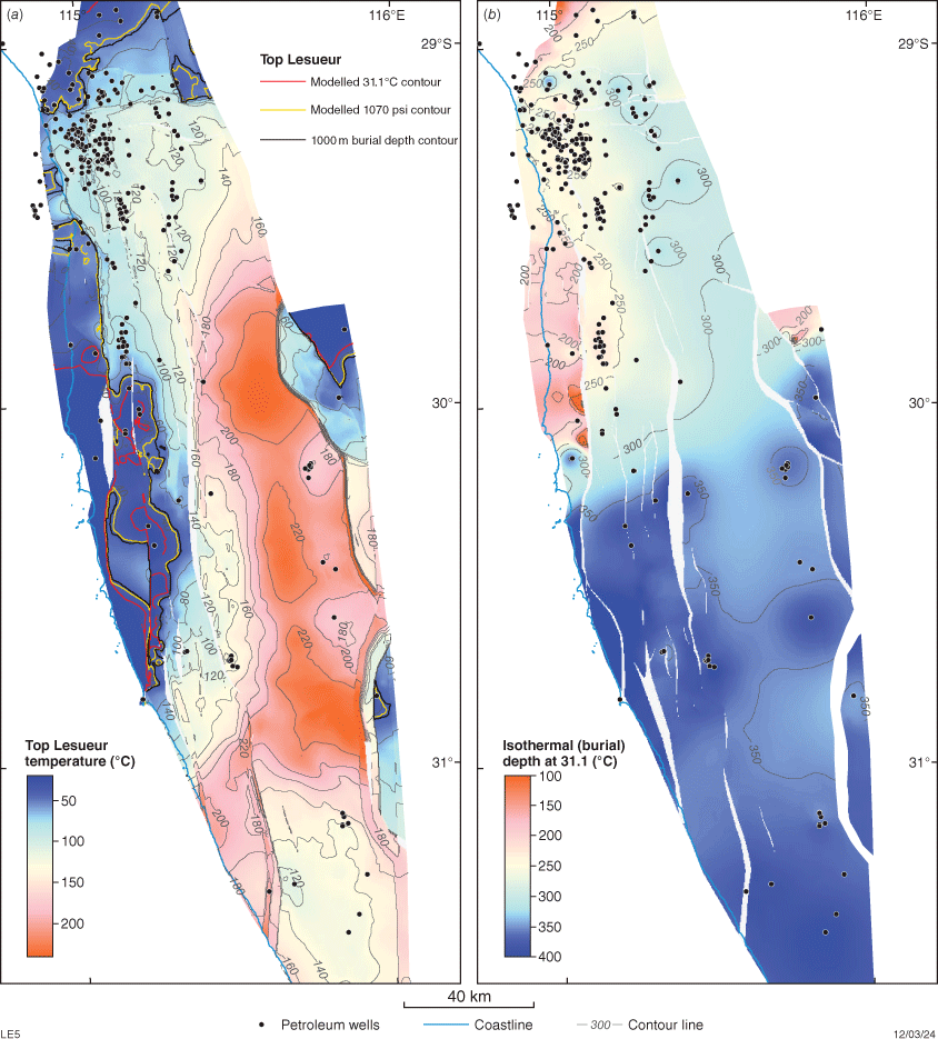
All models for potential reservoir units reveal significant areas within the optimal CO2 storage window, with the deepest reservoirs reaching the optimum temperature and pressure close to the northern edge of the basin and its north-western onshore extent. Conversely, shallower reservoirs lie within the optimum temperature–pressure window in more central positions towards the Dandaragan Trough. An isothermal depth map shows that the critical temperature limit of 31.1°C is shallower in the north and west of the basin where the modelled geothermal gradient is highest (Fig. 2b).
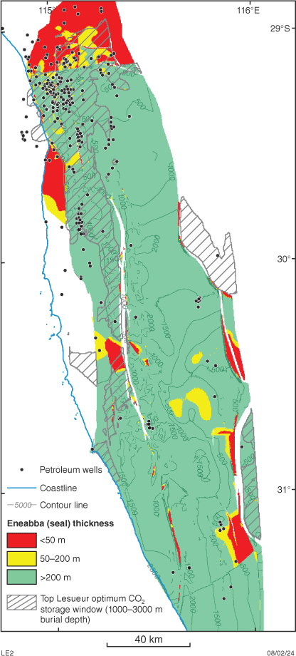
An isopach map of the overlying Eneabba Formation shows that where the Top Lesueur lies within the optimum CO2 storage window (Fig. 3), the Eneabba regional seal is >200 m thick over much of the area. The only exception is a small northern area where the formation is 50–200 m thick or less than 50 m thick (Fig. 3, yellow shaded and red shaded polygons, respectively), which may be riskier in terms of ability to provide adequate seal.
Eneabba Formation isopach (thickness) map showing areas in green and yellow where the formation is likely to be thick enough to be an adequate seal to the underlying Lesueur Sandstone. Areas shaded red indicate thicknesses <50 m and thus higher sealing risk. Areas where the Lesueur Sandstone lies within the optimum burial depth for CO2 are shown by cross hatching.
Summary and conclusion
The latest regional temperature model for the northern Perth Basin incorporates stratigraphic revisions, lithology data, borehole temperature data, and new regional depth maps. Initial assessment of the northern Perth Basin through multi-1D temperature modelling, reveals promising CO2 storage prospectivity, with significant areas identified across various reservoir units falling within the optimum CO2 storage temperature–pressure window. The lateral variation in temperature associated with lithology changes (thermal conductivity), crustal and sediment thickness, and sedimentation rates across the basin, and in conjunction with seal isopach maps, provide a useful preliminary screening tool for identifying where prospective reservoirs exist.
Future work
Future work will extend this assessment to also include reservoir quality parameters and other basins within state jurisdiction. Prospectivity assessments will be significantly enhanced through the inclusion and integration of open-file petrophysical interpretations, well log interpretation and routine core analyses to define variation of formation reservoir quality within the optimal CO2 temperature–pressure window. This workflow and sequence of interpretative work continues, with the final CO2 storage atlas covering the Perth, Carnarvon (including State waters), Canning and Officer basins within state jurisdiction.
Declaration of funding
The CO2 storage atlas of Western Australia is funded by the Western Australian Ministerial Taskforce on Climate Action.
References
3D-GEO Pty Ltd (2013) Western Australian carbon dioxide geological storage atlas: Geological Survey of Western Australia Report 126. Available at https://dmpbookshop.eruditetechnologies.com.au/product/western-australia-carbon-dioxide-geological-storage-atlas-geographical-product-n13au.do
Bachu S (2000) Sequestration of CO2 in geological media: criteria and approach for site selection in response to climate change. Energy Conversion and Management 41(9), 953-970.
| Crossref | Google Scholar |
Bachu S (2002) Sequestration of CO2 in geological media in response to climate change: road map for site selection using the transform of the geological space into the CO2 phase space. Energy Conversion and Management 43(1), 87-102.
| Crossref | Google Scholar |
Beardsmore GR, Cull JP (2001) ‘Crustal heat flow: a guide to measurement and modelling.’ (Cambridge University Press) 10.1017/CBO9780511606021
Bradshaw J, Bachu S, Bonijoly D, Burruss R, Holloway S, Christensen NP, Mathiassen OM (2007) CO2 storage capacity estimation: issues and development of standards. International Journal of Greenhouse Gas Control 1(1), 62-68.
| Crossref | Google Scholar |
Halland EK, Mujezinović J, Riis F (2014) ‘CO2 Storage Atlas, Norwegian Continental Shelf.’ (The Norwegian Petroleum Directorate: Stavanger, Norway) Available at https://www.sodir.no/globalassets/1-sodir/fakta/co-to/storage-atlas-co2.pdf
National Energy Technology Laboratory (2017) ‘BEST PRACTICES: Site Screening, Site Selection, and Site Characterization for Geologic Storage Projects.’ DOE/NETL-2017/1844. (U.S. Department of Energy) Available at https://www.netl.doe.gov/sites/default/files/2018-10/BPM-SiteScreening.pdf
Span R, Wagner W (1996) A new equation of state for carbon dioxide covering the fluid region from the triple‐point temperature to 1100 K at pressures up to 800 MPa. Journal of Physical and Chemical Reference Data 25(6), 1509-1596.
| Crossref | Google Scholar |
Louisa Ellis obtained a BSc (Hons) in Geology (University of Western Australia) in 2001. After a stint in mining, she made the switch to the petroleum industry in 2004, commencing work at Woodside, Perth, where she remained for 15 years. Louisa worked within various teams across exploration and development within Woodside, with her most recent role being 3 years spent in petroleum systems modelling. She joined DEMIRS in 2021 in the position of Senior Geologist within the Energy and Geoscience branch, where she is primarily involved in the creation of an atlas of CO2 storage prospectivity within Western Australia. |
Charmaine Thomas is Senior Geoscientist in the Energy Geoscience and Carbon Strategy Group at the Geological Survey of Western Australia. Her main interests are basin analysis and tectonics, and seismic interpretation. She received a B.Sc. (Hons) from the University of Western Australia in 2006, before joining Woodside Energy as a graduate Geologist in 2007. In 2012, she completed her M.Sc. thesis on the numerical modelling of rift basin initiation and evolution at the University of Sydney. Charmaine is a member of PESA and GSA. |
Julie Cass is a petrophysicist with over 20 years international experience in the oil and gas industry. She currently works for the Geological Survey and Resource Strategy Division of the Department of Mines, Industry, Regulation and Safety. Before joining the survey Julie worked for Chevron Australia in Perth, Marathon Oil and Helix RDS in the UK, and Santos in Brisbane; moving between petrophysical specialist and multidisciplinary project-based leadership positions. Julie has worked on a diverse range of assets, in many countries, across many depositional settings and fluid types. She has experience using a wide variety of log and core based petrophysical evaluation methodologies to produce reliable static, dynamic and rock physics assessments to develop an understanding of reservoir quality controls and evaluate uncertainty. Julie has a Bachelor of Science (Applied Geology) and a Master’s degree in Engineering Science (Petroleum Engineering) from Curtin University. She is a member of PESA, SPWLA and SPE. |
Arthur Mory has been with the provincial Geological Survey of Western Australia for aeons, but still enjoys his role as a churlish curmudgeon. |
Deidre Brooks has been the Manager Energy Geoscience at the GSWA since 2016. Prior to this Deidre worked for over 35 years as a petroleum geologist in technical and leadership roles at Esso, Santos, BHP Petroleum, Woodside and Origin Energy. The work at GSWA has expanded Deidre’s horizons from focussing on petroleum to new and alternative energy-related geosciences such as natural hydrogen, helium, geothermal and CO2 sequestration. |