

Play analysis in the onshore Otway Basin, South Australia
Paul Strong A * , Chris Cubitt A , Tim Rady B , Rob Kirk C and Sharon Tiainen AA
B
C

Paul Strong is a geologist with 40 years of oil and gas experience, having graduated with a BSc (Hons) in Geology from the University of Durham (UK) and an MSc in Petroleum Exploration Studies from the University of Aberdeen (UK). He is Chief Petroleum Geologist at the SA Department for Energy and Mining in Adelaide, after holding a range of senior technical and managerial positions with Santos Limited for nearly 23 years. He is a member of PESA and AAPG. |

Dr Chris Cubitt graduated from the University of Adelaide with a PhD in Clastic Diagenesis and Sedimentology. He has more than two decades of industry experience in reservoir and regional geology working basins worldwide. In 2023 he joined South Australia’s Department for Energy and Mining and is Head of the Basin Prospectivity team. Chris is the author of more than 20 publications, and is a member PESA, IAS and EAGE. |

Tim Rady is a geophysicist with 18 years’ experience in the oil and gas industry, specialising in seismic interpretation, play analysis, prospect maturation and opportunity evaluation. He has worked for Santos, Premier Oil and TotalEnergies on a broad range of new ventures, exploration and development projects across the globe. Tim currently consults to the E&P industry and is the technical subsurface lead for entX Limited’s underground hydrogen storage project. Tim holds a BSc (Hons) in Petroleum Geophysics from the Australian School of Petroleum and an MBA from London Business School. |

Rob Kirk graduated from the University of Adelaide (BSc Hons) and the University of WA (MSc), combining geology with geophysics. He has five decades of industry experience in seismic and sequence stratigraphy having worked some 40 basins worldwide. Rob has given public and inhouse industry courses on seismic stratigraphy for 30 years. Rob jointly won the 1991 AAPG Best Paper Award, was the 1993 and 2014 PESA Distinguished Lecturer, the 1994 Keynote Speaker at GCSSEPM, Houston, and has had regular articles in the PESA Journal. He is a member of PESA and AAPG. |

Sharon Tiainen is a graduate of the University of Adelaide and has an Honours Degree in Petroleum Geology and Geophysics. She has over 25 years of global experience in the upstream oil and gas industry having worked in exploration, appraisal, development and production roles. In 2009 she established her own company, and most recently she joined the South Australia Department for Energy and Mining as a Principal Geologist. She is a member of EAGE, SPE and PESA. |
Abstract
The Otway Basin is one of the best-known Mesozoic rift basins that span the southern coastline of Australia. The onshore portion of the basin covers nearly 10,000 km2 in South Australia (SA), from which both oil and gas have been produced. In 2023, the Department for Energy and Mining conducted an integrated geological, chemostratigraphic, geochemical and geophysical study, which identified intervals of potential hydrocarbon source rocks as well as potential suitable reservoirs, with the information used to prepare a petroleum systems model of the onshore Otway Basin in SA. The model showed significant hydrocarbon generation in the Penola Trough as expected, but also, for the first time, it appears that significant hydrocarbons may have been generated and expelled in the lightly explored Robe and Tantanoola Troughs. Subsequently, the Geological Survey of South Australia conducted play analysis of eight potential hydrocarbon reservoir intervals in the region, to understand the distribution of reservoirs, seals, mature source rocks and potential hydrocarbon migration pathways, to aid hydrocarbon exploration in the region. This process required review of the initial gross depositional environment mapping, with iteration further highlighting prospectivity; the Casterton Formation is presented as an example. Maps for the Lower Sawpit Shale are presented as an example of the play analysis process.
Keywords: Casterton Formation, gross depositional environment (GDE), iteration of interpretation, Lower Sawpit Shale, Otway Basin, petroleum, play analysis, South Australia.
Introduction
The Otway Basin is one of the best-known Mesozoic rift basins that span the southern coastline of Australia forming as a result of rifting between the Antarctic and Australian plates. The onshore portion of the basin covers nearly 10,000 km2 in South Australia (SA) (Fig. 1a), from which nearly half a million barrels of condensate/oil and 86 BCF of gas have been produced.
(a) Central Otway Basin (SA) well and seismic line location map. (b) Onshore Otway Basin stratigraphy (modified from Kirk 2024), with plays reviewed in red and source rocks in purple.
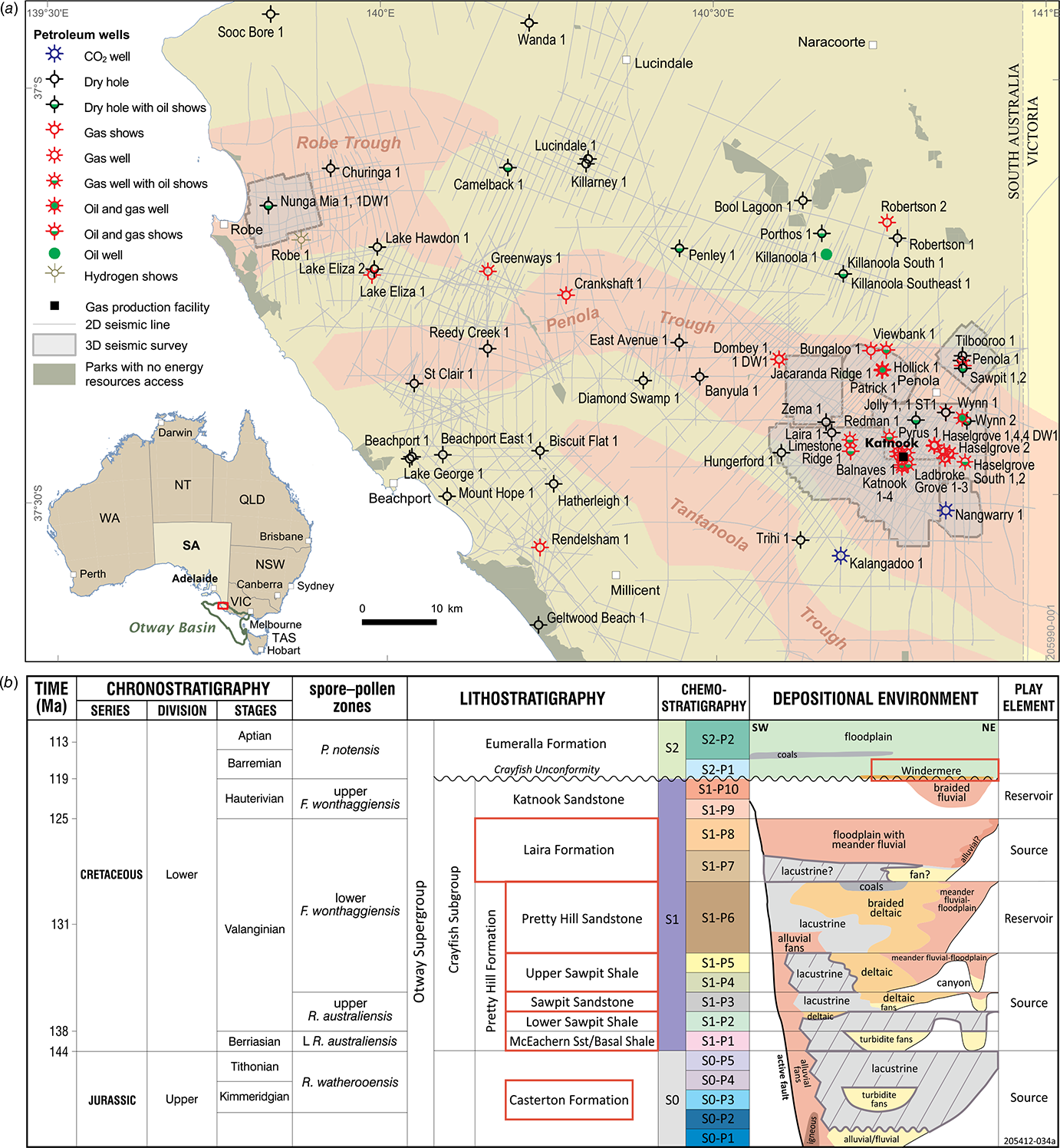
In 2023, the Department for Energy and Mining conducted an integrated study to prepare a petroleum systems model of the onshore Otway Basin in SA, with the model showing significant hydrocarbon generation in the Penola Trough as expected. For the first time it appears that significant hydrocarbons may have been generated and expelled in the lightly explored Robe and Tantanoola Troughs (Edwards et al. 2024).
Play analysis of key intervals in the basin was conducted by the Geological Survey of South Australia (GSSA) following completion of this model as an important part of highlighting the petroleum prospectivity of this region.
Play analysis
What is a petroleum play? A ‘play’ is defined by Rose (2017) as a trend or family of geologically related leads, prospects and possibly producing oil and gas fields, with primary elements of similar geological history of hydrocarbon charge, reservoir/seal pairs and trap controls on their occurrence. They are typically defined by stratigraphic age, with plays generally separated by a regionally significant master seal.
Play analysis, or play-based exploration, is a technique to build and leverage an understanding of geological basins and petroleum systems. The methodology integrates many tools such as seismic and well log data, structural analysis, and geochemistry to define a series of play maps that can be used to focus exploration strategy and improve prospect chance assessment. See Strong (2024) for further discussion of the methodology.
In theory, there is no chance of the play being found outside of its approximate extent, but as with all models the limits are only as good as the data used to construct them. Therefore, this process should not be static, requiring iteration of interpretation following new information from drilling, studies, etc., to update the knowledge base and keep it as evergreen as possible.
Iteration of interpretation
The Casterton Formation represents the first sedimentation on top of the economic Basement in the onshore Otway Basin during the early rifting episode separating the Antarctic and Australian plates in the Jurassic (Fig. 1b). The interval primarily consists of medium to dark brown and dark grey, silty carbonaceous mudstone deposited in a lacustrine environment (Boult et al. 2002).
Fig. 2a shows sketches of the gross depositional environment (GDE) for the Early, Middle and Late Casterton Formation defined from interpretations of seismic and core data (Cubitt et al. 2024), with the drafted summary GDE map displayed in Fig. 2b, also from Cubitt et al. (2024).
(a) GDE sketches showing the evolution of the Casterton Formation (from Cubitt et al. 2024). (b) First pass Casterton Formation GDE map (Cubitt et al. 2024). (c) Final Casterton Formation GDE map from this study.
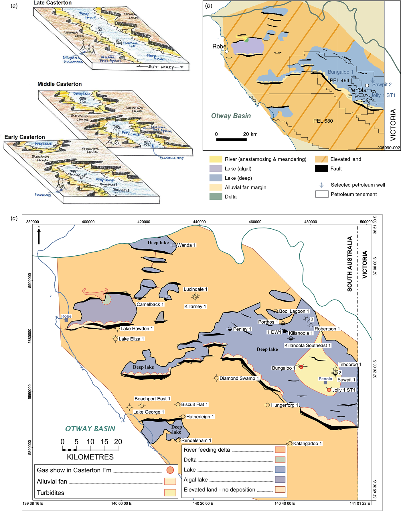
Further review of well data during play mapping of the Casterton Formation resulted in iteration of the GDE map. The Basement section in several wells was reinterpreted to have been reworked during the latest Jurassic as turbidite sands within the Casterton, deposited in the deep lake that filled the Penola Trough. This highlights potential for further prospectivity in the region, with gas shows in the formation in two wells. The final GDE map is shown in Fig. 2c.
Play analysis of the Lower Sawpit Shale
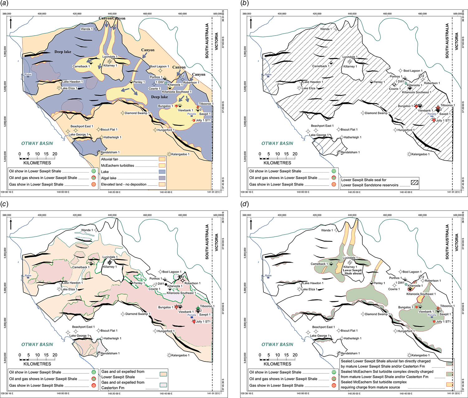
Play analysis was conducted in 2024 by the GSSA to stimulate exploration for additional hydrocarbons in the onshore Otway Basin. Eight intervals were reviewed for reservoir distribution, seal presence, and likely charge from potential source rocks that may have generated hydrocarbons. Fig. 1b shows the seven depositional plays reviewed, plus the fractured Basement.
Play analysis of the Lower Sawpit Shale is discussed below for illustration of the methodology followed.
GDE mapping
GDE mapping enables an understanding of the distribution of a potential reservoir section. Cubitt et al. (2024) described such mapping of six intervals within the onshore Otway Basin in SA, and Tiainen et al. (2024) discussed the reinterpretation of reservoir intervals, focussing on the Lower Sawpit Shale interpreted as being lacustrine turbidites in the Penola Trough. The final GDE map of the Lower Sawpit Shale is shown in Fig. 3a.
Seal
The lacustrine shales of the upper section of the Lower Sawpit Shale act as the seal for the turbidite reservoirs below, illustrated schematically in Fig. 1b. They are interpreted to exist over the whole extent of the Lower Sawpit Shale (Fig. 3b).
Source rocks
Hydrocarbons generated and expelled from mature Lower Sawpit Shale source rocks are likely to have been the main charge for reservoirs within the interval given their juxtaposition. However, gas and/or oil expelled from the older Casterton Formation may also have charged the Lower Sawpit Shale reservoirs given suitable stratigraphic migration paths or via faulting. It is unlikely that the Lower Sawpit Shale has been charged from mature Laira Formation or Upper Sawpit Shale source rocks above.
Fig. 3c shows the extents of modelled gas and oil expelled from source rocks in the Lower Sawpit Shale and the Casterton Formation that may have charged Lower Sawpit Shale reservoirs.
Play mapping
Following determination of the distribution of each of the individual play elements they are plotted together on one map, to review where the suitable elements overlap each other providing potential sweet spots for hydrocarbon accumulations. In other words, to identify where a good reservoir may be overlain by an ideal sealing interval and underlain by a mature source rock that has expelled oil and/or gas.
The summary of the play elements mapping for the Lower Sawpit Shale is shown in Fig. 3d, with the best places hydrocarbon accumulations are likely to exist shown in green.
It must be remembered that the play polygons shown in these maps are interpretive and are only as good as the information used to construct them; the seismic coverage is relatively sparse in some parts of the Otway Basin and the wells are also relatively widely spaced, so there will be some variability on the exact locations of the limits shown. Further investigation of the data may result in revisions to some of the outlines, and of course further seismic acquisition and drilling would help update the interpretations.
Conclusion
Conducting play analysis is one method of stimulating exploration for hydrocarbons in a region, by understanding the distribution of reservoirs, seals, mature source rocks and hydrocarbon migration pathways. Play analysis is simply a technique to build and leverage an understanding of geological basins and petroleum systems, following a methodology that incorporates the integration of many tools. As we have shown in this study, this process should not be static, but iterative as new information from for example drilling, seismic data and studies to update the knowledge base and keep it evergreen; an example of this in the onshore Otway Basin in SA is the Casterton Formation.
The GSSA has recently conducted play analysis in the onshore Otway Basin, with eight intervals reviewed for reservoir distribution, presence of a sealing interval above, and likely charge from potential source rocks that may have generated hydrocarbons. The results of this analysis for the Lower Sawpit Shale have been presented in this paper.
Data availability
All data is available through the SADEM website: https://www.energymining.sa.gov.au/industry/energy-resources/geology-and-prospectivity/mesozoic-basins/otway-basin#PSM2023.
Acknowledgements
We thank DEM management for supporting this work and Elinor Alexander for providing constructive reviews. This abstract is published with the permission of DEM.
References
Boult PJ, White MR, Pollock R, Morton JGG, Alexander EM, Hill AJ (2002) Lithostratigraphy and environments of deposition. In ‘The Petroleum Geology of South Australia. Vol. 1’, 2nd edn Otway Basin. (Eds PJ Boult, JE Hibburt) Chapter 6. Petroleum Geology of South Australia Series. (South Australia Department of Primary Industries and Resources)
Cubitt C, Kirk R, Rady T, Tiainen S (2024) Gross depositional environment mapping in the onshore South Australian Otway Basin: an example of data integration. Australian Energy Producers Journal 64(S1), S347-S353.
| Crossref | Google Scholar |
Edwards C, Rady T, Cubitt C, Kirk R, Tiainen S (2024) Petroleum Systems Analysis of the Onshore Otway Basin, South Australia. Australian Energy Producers Journal 64(S1), S359-S364.
| Crossref | Google Scholar |
Rose PR (2017) Evolution of E & P Risk Analysis (1960-2017); AAPG Search and Discovery Article #42063 (2017). Available at http://www.searchanddiscovery.com/documents/2017/42063rose/ndx_rose.pdf
Strong PC (2024) Play analysis in the Pedirka Basin-Poolowanna-Trough region. In ‘Central Australian Basins Symposium IV, Petroleum Exploration Society of Australia, Special Publication Vol. 2’. (Eds P Strong, M Blades, A Jarrett, V Crombez) pp. 117–128. (PESA) 10.36404/UVTH9170
Tiainen S, Kirk R, Cubitt C, Rady T (2024) Revisiting the rocks discovers turbidites and a new exploration play in the Penola Trough, Otway Basin, South Australia. Australian Energy Producers Journal 64(S1), S435-S440.
| Crossref | Google Scholar |
Paul Strong is a geologist with 40 years of oil and gas experience, having graduated with a BSc (Hons) in Geology from the University of Durham (UK) and an MSc in Petroleum Exploration Studies from the University of Aberdeen (UK). He is Chief Petroleum Geologist at the SA Department for Energy and Mining in Adelaide, after holding a range of senior technical and managerial positions with Santos Limited for nearly 23 years. He is a member of PESA and AAPG. |
Dr Chris Cubitt graduated from the University of Adelaide with a PhD in Clastic Diagenesis and Sedimentology. He has more than two decades of industry experience in reservoir and regional geology working basins worldwide. In 2023 he joined South Australia’s Department for Energy and Mining and is Head of the Basin Prospectivity team. Chris is the author of more than 20 publications, and is a member PESA, IAS and EAGE. |
Tim Rady is a geophysicist with 18 years’ experience in the oil and gas industry, specialising in seismic interpretation, play analysis, prospect maturation and opportunity evaluation. He has worked for Santos, Premier Oil and TotalEnergies on a broad range of new ventures, exploration and development projects across the globe. Tim currently consults to the E&P industry and is the technical subsurface lead for entX Limited’s underground hydrogen storage project. Tim holds a BSc (Hons) in Petroleum Geophysics from the Australian School of Petroleum and an MBA from London Business School. |
Rob Kirk graduated from the University of Adelaide (BSc Hons) and the University of WA (MSc), combining geology with geophysics. He has five decades of industry experience in seismic and sequence stratigraphy having worked some 40 basins worldwide. Rob has given public and inhouse industry courses on seismic stratigraphy for 30 years. Rob jointly won the 1991 AAPG Best Paper Award, was the 1993 and 2014 PESA Distinguished Lecturer, the 1994 Keynote Speaker at GCSSEPM, Houston, and has had regular articles in the PESA Journal. He is a member of PESA and AAPG. |
Sharon Tiainen is a graduate of the University of Adelaide and has an Honours Degree in Petroleum Geology and Geophysics. She has over 25 years of global experience in the upstream oil and gas industry having worked in exploration, appraisal, development and production roles. In 2009 she established her own company, and most recently she joined the South Australia Department for Energy and Mining as a Principal Geologist. She is a member of EAGE, SPE and PESA. |