

Building a world class vegetation classification, mapping and information system that delivers outcomes for government and stakeholders—Queensland’s regional ecosystem framework
Victor John Neldner A * , Gordon Paul Guymer A and Timothy Shane Ryan A
A
Abstract
Vegetation classification, mapping and information systems form an objective tool for natural resource and conservation management and are increasingly used by governments to resolve contested land management policies. The Queensland Herbarium, currently known as Queensland Herbarium and Biodiversity Science (QHBS), has a long history of vegetation survey and mapping dating back to 1946. This extensive sustained experience has led to the innovative world-leading regional ecosystem framework that is a key government conservation planning instrument that has been pivotal in improving conservation outcomes as well as reducing tree clearing and carbon emissions from the agricultural sector in Queensland. There were multiple significant international drivers for reform in the management of the Queensland natural landscape. The Convention on Biological Diversity 1992, and the Kyoto Protocol 1997, and subsequent international climate agreements, together with National Forest Policy and state land lease review, were key drivers for land management and biodiversity conservation policy changes. The essential enabling ingredients for Queensland’s land management and biodiversity conservation policy changes were secure majority government, political leadership, and significant land management reforms, that could be implemented and supported by a skilled and well-managed, multi-disciplinary scientific team with the access to state-wide affordable imagery, and a legally-defensible scientific methodology that was accepted by most stakeholders. There are continuing improvements in the methodology and products as better imagery, new tools and models (for example vegetation condition) and more comprehensive site data become available.
Keywords: biodiversity assessment, conservation, land clearing, Queensland, regional ecosystem, vegetation management, vegetation mapping, vegetation survey.
Introduction
Vegetation classification and mapping systems form an objective tool for conservation and natural resource management and provide for the ecological exploration of the natural patterns and drivers of species’ distributions (Kent 2012). Applying a vegetation classification system for management purposes through a map showing geographical areas of similarity within the jurisdiction is common, with maps being a frequently associated component (Addicott and others 2021). The demand for vegetation classification systems and maps is steadily increasing because of their direct applicability across a broad range of issues (Chytrý and others 2011; Wesche and von Wehrden 2011). The Queensland Herbarium and Biodiversity Science (QHBS) has a long history of vegetation survey and mapping dating back to 1946, with botanical involvement in multi-disciplinary land system surveys, and then leading systematic vegetation surveys across Queensland since 1971. This has led to the innovative world-leading regional ecosystem framework that is a key government conservation and natural resource planning instrument that has been pivotal in reducing vegetation clearing, and consequently reducing carbon emissions from this clearing throughout Queensland.
Vegetation survey and mapping in the Queensland Herbarium and Biodiversity Science (QHBS)
QHBS has a history dating back to 1855, four years before Queensland became a separate colony (Neldner 1993). The first involvement of QHBS staff in vegetation survey and mapping occurred in 1946 and 1947, when Stan Blake, was seconded as botanist with the CSIRO Northern Australia Regional Survey Team to survey the Katherine-Darwin region. Blake had been appointed as a permanent staff member to QHBS in 1945, but had published an earlier pioneering 1:2,800,000 map and account of the vegetation of western Queensland (Blake 1938). Botanical and taxonomic studies continued to be the major thrust of research of QHBS from this time, with important studies into poisonous plant problems, and edible trees and shrubs being undertaken from the late 1940s onwards. From 1954 to 1972, QHBS officers were involved in major trials to evaluate chemical controls of Brigalow (Acacia harpophylla) regrowth (Johnson 1964).
It was not until 1964 that QHBS again became involved in a major vegetation mapping project. Les Pedley was seconded to the CSIRO Land Research Series team as plant ecologist for the survey of the Nogoa-Belyando area in central Queensland. The report for this area was published in 1967 (Pedley 1967), and included two vegetation maps at a scale of approximately 1:1 M, one showing the tree communities and the other the pasture communities. These vegetation maps were derived from the larger scale land system classification map (1:500,000) without reinterpretation of the aerial photographs.
In 1968, Pedley in conjunction with Ray Isbell of the CSIRO commenced and completed the field sampling of the Cape York Peninsula area. The 1:2 M vegetation map and accompanying report were published in 1971 (Pedley and Isbell 1971). This map was derived by interpreting the large photo-mosaics that were used in the Atlas of Australian Soils project for that area.
Pedley was once again seconded by CSIRO to work as botanist for the Balonne-Maranoa survey in 1970. The maps and report for this survey were published in 1974 (Pedley 1974). As for previous CSIRO studies, the vegetation maps produced were derived from the land system classification maps. There was no reinterpretation of the photo-mosaics.
In response to the disastrous drought of 1964–6 in western Queensland, the Queensland Department of Primary Industries Western Arid Region Land Use Study (WARLUS) was commenced in 1969. Staff from Development Planning and Agricultural Chemistry Branches and QHBS were involved in this massive study, which covered approximately 80 million hectares of inland Queensland. Des Boyland of QHBS was involved in Parts I (Boyland 1974) and Parts II (Boyland 1980) of the WARLUS studies. Other QHBS officers involved in the WARLUS studies were Rosemary Purdie—Part III (Purdie and McDonald 1990) and Part VI (Purdie 1990); Greg Beeston—Part IV (Beeston 1978) and some of Part V, and Bill McDonald and Megan Thomas—Part V (McDonald and Thomas 1993). In all of these studies, it was the Development Planning Officer who was primarily responsible for the photointerpretation of the black and white aerial photographs (1:80,000 scale). This officer marked up land system boundaries on the aerial photographs, and the land system maps were produced at 1:500,000 scale. The vegetation maps were produced at 1:1 Million scale and derived from the land system maps by the botanist, without major alterations to the land system boundaries.
Moreton region survey and mapping
An Ecology Section was formally set up in QHBS in February 1971. The staff of the Section and their chief projects were John McDonald (Leader of Ecology section and sand dune ecological studies), Des Boyland (WARLUS), Lorraine Durrington (Moreton Region vegetation), Greg Beeston (Ecology and control of Eremophila mitchellii), and Paul Back (Brigalow and Dawson gum control).
In 1975, QHBS commenced a survey of the natural vegetation of the Moreton Region. This study was partly funded by the Commonwealth Government through the National Estate Program. Four maps at 1:100,000 scale were produced as part of this study: Brisbane (Dowling and McDonald 1976), Beenleigh (Elsol and Dowling 1978), Caloundra (Elsol and Sattler 1979), and Murwillumbah (McDonald and Whiteman 1979). A variety of scales of aerial photographs were used to construct these maps (1:20,200, 1:24,000 and 1:32,000), and some colour photographs were used for the first time. Botanists from QHBS were primarily responsible for the photointerpretation, but only mapped relatively undisturbed vegetation. No interpretation was made of areas that had been previously cleared or severely modified. A summary report for these four map sheets was published in 1984 (McDonald and Elsol 1984). The mapping scale for this study was then changed to 1:250,000, and two map sheets have been worked on at this scale, Warwick (Young and McDonald 1989) and Ipswich (Elsol 1991). This latter series of maps includes the vegetation extent before land clearing as a result of settlement, this is now commonly referred to as pre-clearing vegetation extent.
Vegetation survey of Queensland
The early 1970s saw an upsurge in interest in preparing a complete set of vegetation maps of Australia to uniform specifications. The idea was proposed by John Carnahan of the Australian National University at the 1971 Australian and New Zealand Association for the Advancement of Science (ANZAAS) Congress.
In 1973, the Commonwealth government set up a program known as the Australian Biological Resources Study (ABRS) to promote biological surveys, taxonomic studies, and mapping of Australia’s flora and fauna. With the formation of the ABRS Interim Council in 1974, the need for a uniform, or at least compatible, series of vegetation maps covering Australia was highlighted. A mapping program was already well underway in Western Australia and New South Wales. In April 1975, the Botanical Subcommittee of ABRS invited the principal workers involved in vegetation survey and mapping to a meeting to endeavour to reach agreement on uniformity of mapping specifications. Twelve recommendations were submitted to the Interim Council of ABRS, and these guidelines were accepted in July 1975.
Initially, with funding from the National Estate Program in 1977–8, and supplementary funding from ABRS, QHBS embarked on a project to map the vegetation of Queensland at a scale of 1:1 M, with compilation at 1:250,000 scale. Nine map sheets were planned, and the ABRS guidelines followed. The South Western Queensland area was selected to be the first study area, and Des Boyland was given the task of producing the map and explanatory book. The map was published in 1979, but the explanatory book was not published until 1984 (Boyland 1984).
In 1979, John Clarkson was transferred to the new QDPI facility at Mareeba to begin flora inventory work in the Far Northern Queensland area. This work was supported by ABRS funding for five years. A 1:250,000 map and report for a mining lease near Aurukun was produced in 1982 (Clarkson 1982).
The 1:1 M map and explanatory book for South Central Queensland was published in 1984 (Neldner 1984) and for Central Western Queensland in 1991 (Neldner 1991). The Far Northern Queensland survey and mapping was completed in 1994 as part of the Cape York Peninsula Land Use Study (Neldner and Clarkson 1995).
Large scale survey and mapping
From 1975 to 1983, QHBS officers were involved in dune vegetation surveys in conjunction with the Beach Protection Authority. These maps were published at 1:25,000 and covered areas of coastline in the northern (McDonald 1984), central (Batianoff and McDonald 1980), and southern (Batianoff and Elsol 1989) parts of the state.
Vegetation mapping of mangrove communities was commenced in conjunction with the Queensland Fisheries Service in 1973, and continued until 1980. Large scale maps (1:12,500–1:25,000) have been produced for Fisherman Island area (Durrington 1973), Round Hill Head to Tannum Sands (Dowling 1980), Trinity Inlet (Dowling 1983), and Moreton Bay (Dowling 1986).
Vegetation maps at 1:25,000 scale were also prepared for other Branches of the QDPI to assist in the management and planning of research on various research stations, including Brigalow Research Station (Johnson 1970), Brian Pastures (Neldner and Paton 1986), and Batavia Downs (Neldner and Clarkson 1991).
A number of other large scale vegetation maps at 1:5000 scale were produced for various Queensland coastal islands: Lizard Island (Byrnes and others 1977), Lady Musgrave Island (Elsol 1985), and Penrith Island (G. N. Batianoff, unpubl. data).1 Some of these surveys were partly supported by Queensland National Park and Wildlife Service (QNPWS).
The unique regional ecosystem framework
In late 1989, the new Queensland Government had, as its premier environmental policy, to double the National Park estate and for it to be representative of the state’s biodiversity. This policy was based on Paul Sattler’s presidential address to the Royal Society of Queensland in 1983 (Sattler 1986; Comben 1999). Implementation of this policy was based on securing a representative park system across each of Queensland’s 13 bioregions.
Two approaches were adopted (Sattler 1993). Where extensive land system mapping was available, namely the Mulga Lands and the Channel Country, quantitative selection techniques were used for the first time to select parks to achieve comprehensive representation of land systems (Purdie 1986). For all other bioregions where mapping had not been fully carried out, regional ecosystems were identified for each bioregion through extensive technical workshops across the state by specialist staff and staff of the Queensland Herbarium.
After ten years of work the unique regional ecosystem classification system was developed, and published in The Conservation Status of Queensland’s Bioregional Ecosystems (Sattler and Williams 1999). This work provided a means to identify important conservation areas whilst the mapping of Queensland was completed.
Development of the regional ecosystem framework
The framework has its origins in the study of Stanton and Morgan (1977) that led to the description of bioregions and their major vegetation communities (Sattler 2017). At that time the knowledge of Queensland’s ecosystem biodiversity was limited to the variable spatial mapping of geology by the Queensland Department of Resources at 1:250,000 scale over all of the state, WARLUS and CSIRO land system mapping at 1:500,000 for some areas in the west of the state, and very limited systematic vegetation or soils mapping by the QDPI, which was either associated with the land system studies or small areas on the coast (Neldner 1993). This patchwork of available mapping allowed Stanton and Morgan (1977) to develop their bioregional framework.
In the classification of Queensland’s regional ecosystems, three major attributes are combined in a hierarchical manner:
Broad-scale landscape patterns as described by bioregion
Geology, soils and landforms which are described as land zones
Vegetation which is described in terms of structure and floristics (Sattler 1999).
The bioregions of Queensland initially described in Stanton and Morgan (1977) at a scale of approximately 1:1–1:2.5 m, were used as a template to develop and apply the bioregional concept across the whole of Australia in the Interim Biogeographic Regionalisation of Australia (IBRA) (Thackway and Cresswell 1995).
Within bioregions, there are generally significant difference in landscape patterns usually associated with geology and geomorphology or climatic differences. While these distinctive sub-regions within the bioregion were called ‘provinces’ by Morgan and Terrey (1990) and Sattler (1999), the term ‘subregion’ has been adopted by QHBS since the year 2000 to reinforce the hierarchical relationship.
The second level in the hierarchy relates to land zone. Land zones represent significant differences in geology and associated landforms, soils and physical processes (Sattler 1999). Land zones generally corresponded to broad geological categories or groupings of these, and were related to units on the geological maps (Sattler 1999). The geology maps covered the state of Queensland in a series of 1:250,000 scale individual maps that did not always edge-match to the adjoining map, and sometimes offered different interpretation of certain geology types. Geology maps focus on the below surface hard rock materials, with varying levels of detail in regard to overlying regolith and depositional surfaces necessary for accurate land zone identification. Over time the geology and soils mapping has improved, and the concepts of land zones tested and refined, leading to the more consistent definitions and descriptions (Wilson and Taylor 2012).
The third level in the hierarchy is the vegetation community which under the modified Specht (1970) classification system is defined in terms of the structure and floristics of the ecologically dominant layer, with the landscape position and characteristics as further attributes to define communities (Methodology for survey and mapping regional ecosystems and vegetation communities in Queensland, Version 6.0, Neldner and others 2023b).
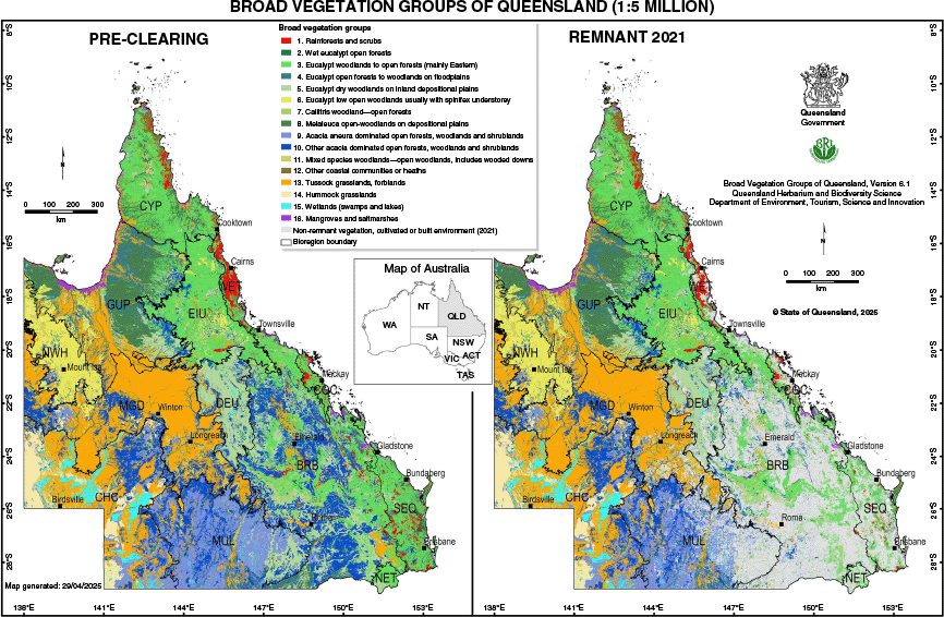
A regional ecosystem (RE) is defined as a vegetation community in a bioregion that is consistently associated with a particular combination of geology, landform and soil (Sattler 1999). The RE classification also allows biodiversity mapping at various aggregated scales through Broad Vegetation Groups defined at 1:1 M, 1:2 M or 1:5 M scale. This has allowed the complete vegetation of Queensland to be summarised in Neldner and others (2023a) (see Fig. 1).
Why the need for the regional ecosystem framework?
Vegetation communities and vegetation maps have been, and continue to be, used as surrogates for total biodiversity. However, research has shown vegetation communities are better surrogates for certain groups of biodiversity. For example, forest ecosystems were most effective for plants and mammals, but are least effective for some other important groups, such as frogs and reptiles (Grantham and others 2010). Both the regional ecosystem and vegetation community classification use biophysical attributes, such as landforms, soils and geology, and vegetation characteristics, such the height and cover of structural layers, and the dominant species present in these layers, to define recognisable ecological entities. However, the hierarchy of applying these characteristics is more consistent in the regional ecosystem approach than for vegetation communities. The elevated importance of biophysical attributes has also been used by the Victoria state-wide biodiversity classifications of Ecological Vegetation Classes (EVCs) (Sun and others 1997).
The underlying premise is that different biophysical environments, represented by land zones and bioregions in the RE structure, will enable regional ecosystems to provide more effective surrogacy for the full scope of biodiversity, including unique and distinct biodiversity, than classifications based only on vegetation communities. This premise is still a topic of further research, although for some ecosystems, for example, semi-evergreen vine thickets, different substrates do not appear to significantly change the structure and floristics of the vascular plants present (Fensham 1995; McDonald 1998). There is also clear evidence of the biophysical attributes being a primary driver for the types of plant and other species that occur at a site.
The other factor that led to the adoption of the regional ecosystem mapping for the official biodiversity planning classification for Queensland was that knowledge of biophysical environments across the state was sufficient to enable rapid development of an initial state-wide regional ecosystem coverage that could support vegetation management legislation, by utilising existing mapping products. The biophysical geology coverage at 1:250,000 scale, complemented by the WARLUS and CSIRO land research series land system mapping, provided a relatively consistent framework to develop a state-wide environmental coverage that focused initially on biophysical characters.
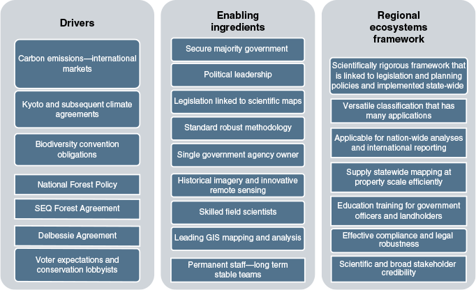
The development of proposed legislation, which eventually become the Vegetation Management Act 1999 (VMA), and the desire to link this to a spatial mapping framework and Information system for implementation and regulation, led to the decision of the Queensland Environmental Protection Agency in 1995 to adopt the regional ecosystem framework as the biodiversity framework for Queensland. The QHBS Regional Ecosystem Survey and Mapping (QHRESM) program was developed to produce a consistent, seamless, versatile, best-practice, and legally-defensible 1:100,000 scale regional ecosystem coverage of the state of Queensland. Fig. 2 provides a summary of the policy drivers, enabling ingredients and essential components that produced the robust Regional Ecosystems framework.
There were two significant international drivers for reform for the management of Queensland’s natural landscapes: The Convention on Biological Diversity (CBD) 1992 and United Nations Framework Convention on Climate Change 1992 (UNFCCC). The CBD 1992 imposes extremely wide and important obligations on Australia. Article 8 imposes a general obligation on Australia to conserve biodiversity in both terrestrial and marine ecosystems. In response to this question of how well jurisdictions are meeting the CBD conservation obligations, the aspirational outcome was a Comprehensive, Adequate and Representative (CAR) reserve system, and this requires a systematic mapping and classification to plan and implement it. A report by the Organisation for Economic Co-operation and Development (OECD) on Australia’s environmental performance, concluded that, ‘Australia is one of 17 megadiverse countries’, however, in Australia ‘the overall status of biodiversity is poor and worsening.’ (OECD Publishing 2019). Australia compares internationally as the second highest-ranked country for biodiversity loss, surpassed only by Indonesia. At the national level in 2021, 89 ecosystems, 533 terrestrial and aquatic animal species and 1,385 plant species are listed as threatened (DCCEEW 2021). The greatest threats to Queensland’s biodiversity are land clearing causing habitat loss, invasive species, diseases, inappropriate fire regimes, illegal wildlife trade, pollution and climate change. Land clearing alone has had a dramatic impact on biodiversity in Queensland, and has been associated with species extinction, as well as being a threatening process for a number of other species (Neldner and others 2017a).
The United Nations Framework Convention on Climate Change 1992 (UNFCCC) provides an international framework for regulating anthropogenic climate change. As a contracting party, Australia is obliged to take action to avoid dangerous climate change. The Kyoto Protocol 1997 aimed to limit greenhouse gas emissions for the period 2008–12, and then 2013–20. The 2015 Paris agreement set the goal of holding the increase in global average temperature to well below two degrees above pre-industrial levels. International law impacts upon the Queensland environmental legal system in three major ways by placing legal obligations on Australia to protect the environment; creating legislative power for the Commonwealth Government to fulfil Australia’s international legal obligations; and sometimes being relevant to the interpretation of domestic legislation (McGrath 2020).
The Commonwealth Government has a constitutional power to implement Australia’s international legal obligations. The Environment Protection and Biodiversity Conservation Act 1999 (EPBC) is the centrepiece of Commonwealth environmental laws. The Commonwealth set up under the National Greenhouse and Energy Reporting Act 2007, a national system for reporting large greenhouse gas (GHG) emissions, abatement actions, and energy consumption and production by corporations. This Act lays the foundation for Australia’s responses to climate change.
The emissions of carbon from tree clearing was one area that the Queensland government could implement regulation to reduce emissions. A framework for the creation and management of protected areas (such as national parks), and the protection of native flora and fauna (protected wildlife) is provided by the Nature Conservation Act 1992.
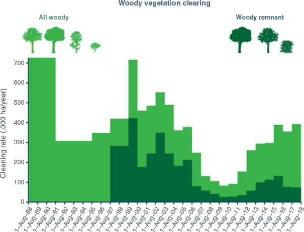
Queensland has had a checkered history of clearing native vegetation. The rate of clearing in the 1990s and 2000s being up to 700,000 ha per year (Fig. 3) meant that native vegetation clearing pushed increasingly into more marginal areas. Further, there was little regard to protecting key habitats or vulnerable parts of the landscape. These important and vulnerable parts included riparian corridors along watercourses, clearing of steep slopes, erodible soil types, habitats of key species, and vegetation types that had been cleared to such an extent that many species and ecosystems were threatened with extinction (Sattler 2017). Prior to the 1990s, there was little regulation of vegetation clearing. In late 1997, a system to control vegetation clearing on the 70% of Queensland held as leasehold and other State lands commenced under the Land Act 1994. In late 2000, using a new mapping and classification system, a separate regime commenced in the Vegetation Management Act 1999 (VMA) and Integrated Planning Act 1997 (IPA) to regulate clearing on the 30% of Queensland held as freehold land and freeholding leases. Faced with ongoing controversy and high levels of vegetation clearing, in 2004 the State Government introduced major reforms to phase out broadscale land clearing by 31 December 2006. The reforms collapsed the system of clearing laws for State lands in the Land Act 1994 (Qld) into the VMA/IPA system. The IPA component of that system is now contained in the Planning Act 2016 (PA). Vegetation management on approximately 90% of Queensland is now regulated primarily under the VMA/PA system (VMA system). Areas not regulated under the VMA system include those dominated by mangroves or non-woody plants e.g. exempt grasslands and Protected Areas under the Nature Conservation Act 1992. The VMA does not itself regulate vegetation management. Instead, the trigger and process for assessment, together with the offence for clearing without approval, are contained in the PA (McGrath 2020).
Reduction of both regulated clearing and all woody clearing in Queensland 1988–2018. SLATS (SLATS (State Land and Tree Study) (2025).
To provide landholders with certainty of property management, Property Maps of Assessable Vegetation (PMAVs) were introduced as part of the same round of legislative changes, and allowed non-remnant areas to be ‘locked in’ on these property scale maps, which were approved by the Department of Natural Resources and Mines, now called Department of Natural Resources and Mines, Manufacturing, and Regional and Rural Development (DNRM). PMAVs and subsequent other legislative changes mean that the area regulated by the VMA no longer equates to remnant on the regional ecosystem maps. Instead, a map of assessable vegetation applicable under the VMA is constructed by DNRM from the RE maps, PMAVs, and other sources. This shift is partly because the range of vegetation regulated under the VMA has expanded beyond only remnant vegetation. For example, it now includes vegetation within buffers of watercourses in Great Barrier Reef catchments, as well as high-value regrowth, which is defined as native vegetation regrowth that is greater than fifteen years old. However, the regional ecosystem classification and mapping continues to be the foundation that determines what activities may occur in specific areas within the various classes of regulated vegetation. The RE mapping and biodiversity status assigned to each RE informs environmental protection associated with mining, which is regulated under the Environment Protection Act 1994.
The regional ecosystem maps are used to calculate the extent remaining and the appropriate vegetation management class for each RE. For land holders to apply the various VMA codes, for example, fodder harvesting, managing encroachment, managing weeds, they must refer to the appropriate mapped regional ecosystem.
The dramatic reduction in vegetation clearing since the implementation of the Vegetation Management Act 1999 is illustrated in Fig. 3. Total vegetation clearing rates have been reduced from over 700,000 ha per year to under 400,000 ha, with regulated vegetation clearing being consistently below 100,000 ha per year. Significant lower rates of clearing have been maintained since 2018 (Department of Natural Resources and Mines (2000, 2004; SLATS (State Land and Tree Study) 2016; DES 2018, however, the State Land and Tree Study (SLATS) methodology was updated after 2018. Clearing of regulated vegetation was 71,100 ha and total vegetation clearing 323,700 ha in 2021–2 (SLATS (State Land and Tree Study) 2025).
Political leadership
In December 1989 the Queensland government changed after thirty two years of conservative governments to the Goss Labor government. Pat Comben was appointed the Minister of National Parks with a policy of doubling the National Park estate (Sattler 2017). Numerous National Park proposals, many from the National Parks Association of Queensland, that had been prepared but ignored by previous conservative governments were able to be rapidly acted on with the assistance of Lands Department valuers (Sattler 2017). Minister Comben enabled the new Nature Conservation Act to be developed in 1992. This was based on extensive review, the consolidation of a number Acts dealing with nature conservation, and included the identification of a range of conservation tenures to complement the strict preservation objective of National Parks (Sattler 2017). Over the 1997–9 period, more than $6 million was secured from the Commonwealth (Howard) government for acquisitions in Queensland with each proposal carefully scrutinised by Senator Robert Hill as Commonwealth Environment Minister. Under the first Natural Heritage Trust program, the allocation of $80 million for the protected area system funds were made available to the States, Territories and other partners on a 2:1 basis. The Queensland biogeographic approach was adopted nationwide as a framework for conservation planning for both park consolidation and other conservation activities (Sattler 2017).
Peter Beattie AC was Queensland’s long serving Labor Premier in the years between 1998 and 2007, and had a desire to bring in reforms and innovation to Queensland. Beattie had excellent communication skills, and together with Rod Welford (the Natural Resources Minister), and strong lobbying from informed conservation groups such as the Australia Rainforest Conservation Society and World Wildlife Fund, his government brought in the controversial VMA 1999, which applied to both freehold and leasehold land. After extensive public debate, often heated, the VMA was enacted in September 2000.
Scientific leadership
The QHRESM program has benefited from strong and stable long-term leadership at QHBS (Dr Gordon P. Guymer, director of QHBS 1994–2022), science leaders Bruce Wilson (2002–16), Dr John Neldner (1996–2025), Dr Don Butler (2016–8) and Tim Ryan (2018-ongoing), principal scientist Dr Arnon Accad (1997-ongoing, expert GIS standards leadership) and higher levels of the Environment Department (Paul Sattler, 1976–2000), that were able to obtain essential resources to accelerate the delivery of vegetation mapping. It had strong Queensland government support (Dr Andrea Leverington in DNRM, 1997–2005, and Adrian Jeffreys in the Premier’s department, 1998–2005), that enabled the Beattie government to be convinced of the need and benefits of the regional ecosystem framework, and that it could provide the rigorous scientific backbone to implement vegetation management reform.
The regional ecosystem framework was delivered by a single agency, QHBS, which had built up a reputation of delivering high-quality science in a timely manner. The recognition of these scientific skills led to Dr Rod Fensham and Russell Fairfax of QHBS being recognised as winners of the Sherman Eureka Prize for Environmental Research in 2005, ‘for innovative biodiversity and woodland dynamics research that provided the drive behind a range of conservation measures to protect native vegetation threatened by land clearing. This research underpins the scientific rationale for legislation prohibiting broad scale land clearing in Queensland in 2006’ (Australian Museum 2025). Long-term scientific leadership from officers with practical field botanical and vegetation survey experience was also important in guiding the development of best practice ecological skills and methods. Leadership was required to ensure coordination and training of staff to ensure adherence to the established techniques.
Cooperative working with other departments, particularly DNRM, at both the policy and operational levels was essential in implementing the RE mapping program and the VMA operations. The close cooperative relationship with the Remote Sensing Centre and SLATS project was essential in facilitating the success of the RE survey and mapping program.
The RE framework had to develop well-defined, unambiguous and legally defendable definitions of various attributes of the framework to provide the necessary objective and robust framework to underpin such a controversial land management reform policy.
These included:
Defining pre-clearing and remnant vegetation
Defining land zones (a unique geomorphological construct in the RE framework)
Defining scale of RE mapping and classification
Defining acceptable natural variation within vegetation
Defining natural or anthropogenic disturbance
Developing a consistent field classification that was transparent in a published methodology.
The details of the development of these concepts and their definitions are described in Neldner and others (2023b). An example of how these concepts and definitions were used to dismiss a legal appeal against a well-publicised decision by the Department of Natural Resources, Mines and Energy, now DNRM, is the Knuth & Ors v Department of Natural Resources, Mines and Energy [2022] QCATA (Queensland Civil and Administrative Tribunal 2022).
Resourcing and skilling teams
As summarised earlier, QHBS had developed small teams with vegetation survey and mapping expertise through being involved in the CSIRO land research series and WARLUS land system mapping projects intermittently from 1945 to 1980. The Moreton Region Non-Urban Land Suitability Study provided additional funding that allowed an ecology section of five officers to be set up at the QHBS from 1971.
Commonwealth resources through the National Estate program partly funded the Moreton Region series in 1975 as well as the Vegetation Survey of Queensland (VSQ), which commenced in 1978.
The Cape York Peninsula Land Use Study (CYPLUS) delivered additional funding to the vegetation survey and mapping program from 1990 to 1994, and added three temporary staff to the two permanent staff in Mareeba (Neldner and Clarkson 1995). The Southeast Queensland Comprehensive Regional Assessment (SEQCRA) commenced in 1994 in preparation for a Regional Forest Agreement, and provided funding for six temporary staff in Brisbane (Bean and others 1998).
The largest expansion of staff occurred from 1996 as the Queensland government invested funding in the regional ecosystem mapping program. At its largest staff size in 2000, the vegetation survey and mapping and associated vegetation management groups consisted of twenty-one botanists, eight technicians, and seven Geographic Information Officers, with five staff based in Mareeba, five in Townsville, two in Emerald, one in Longreach, one in Gladstone, and twenty-four in Brisbane.
The Delbessie Agreement (State Rural Leasehold Land Strategy) was a partnership between the Queensland government and stakeholders that took effect from 1 January 2008. The ‘Guidelines for determining lease land condition’ are designed around the eight elements of the Land Act 1994 ‘duty of care’ and defined elements of land degradation (Hassett and others 2010). The assessment of long-term land condition from a grazing land management perspective, also advanced the development of the BioCondition method that assessed site condition from a biodiversity perspective (Eyre and others 2015).
In 2018, four additional staff were employed in a two-year project to produce an initial vegetation condition map for Queensland. This QVEG project (later called Spatial BioCondition) was part of a broader enhanced SLATS (eSLATS) project funded by the Queensland Government. The funding for the eSLATS program is ongoing, with the Spatial BioCondition project delivered vegetation condition mapping for the Southeast Queensland and Brigalow Belt bioregions in 2022, and Central Queensland Coast bioregion in 2024 (DES (Department of Environment and Science) 2021).
The well-funded projects that sustained the survey and mapping program were jointly Commonwealth and Queensland Government-funded, with the aim of informing land use planning decisions, and then the Queensland Government initiatives to support the VMA policies.
Other smaller project funding has come through the Cooperative Research Centre for Tropical Savannas (Fox and others 2001), and the National Vegetation Information System (NVIS) (Executive Steering Committee for Australian Vegetation Information (ESCAVI) 2003). The Terrestrial Ecosystem Research Network (TERN) provided funding for entering the ecological site data into the CORVEG database (McDonald and Dillewaard 1994), in 2023 updated to the Queensland Biodiversity and Ecosystem Information System (QBEIS), and the TERN Data Portal, and southeast Queensland local governments (Brisbane, Gold Coast and Logan City Councils) funded regional ecosystem mapping to 1:25,000 scale.
Ensuring consistency in the mapping outputs
QHBS botanists are responsible for the interpretation of imagery, mapping of vegetation and field data collection, which ensured the laboratory interpretation mirrored the reality of the field. This differed from some organisations, where the specialities of aerial photointerpretation and field data collection were kept separate. The development of specialist Geographic Information System skills was also essential to the success of the QHRESM program.
These GIS officers developed efficient and best practice routines for processing and storing aerial photographs and satellite imagery, capturing line work from imagery, building mapping coverages, and analysing the spatial data. The GIS officers also trained the botanists in GIS skills and were available to resolve issues with the mapping coverages and the site data underpinning it.
Within a team of vegetation mappers, there are invariably splitters (frequently driven by the complexity detected at the site level), and lumpers (driven by the patterns shown on imagery). As the scale and detail of imagery improves, more features can be seen and potentially delineated. To foster a consistent level of mapping, a preferred mapping protocol is specified in Neldner and others (2019b), which uses the patterns detected on imagery as primary source of the delineated polygons.
Appendix 3 in Neldner and others (2023b) provides principles for the regional ecosystem classification to deal with changing vegetation, and some examples of how these situations are dealt with.
The pressure for more detailed (larger scale) mapping
While the RE mapping was designed to be used at the regional scale of 1:100,000, the ready availability and high-quality of the mapping led to RE mapping being used for planning for local government authorities, landholder properties, and even individual developments. Despite the caveats and limits of use statements on the map coverages, there were many occasions where the GIS technology allowed the mapping to be pushed beyond its intended scale of use.
This pressure for more detailed mapping has increased with better quality and more affordable and readily available imagery (both aerial photographs and satellite imagery have become available through coordinated state government acquisition programs), cheaper products, and more users from a diverse variety of sectors (Neldner and others 2019a). A high resolution imagery basemap is now freely publicly available on Queensland Globe (https://qldglobe.information.qld.gov.au) where the RE mapping may be overlain and viewed at any scale.
The requirement for homogeneous polygons (single RE only in each polygon) for ease of use and clarity is also a strong driver from stakeholders. Improvements in the scale and quality of geology mapping also generated the requirement to revise land zones and subsequently REs in some areas.
The demand for more detailed mapping required the definition of subregional ecosystem units. These are defined as vegetation communities and criteria provided for recognising new vegetation communities (Neldner and others 2023b).
Multiple Queensland local governments have funded larger scale mapping for their LGAs, and would then request this larger scale mapping be incorporated into the state government RE coverage.
Stitching in larger scale mapping raises many technical issues and can be impossible if the classification concepts of remnant vegetation and REs are inconsistent. Some LGA mapping had to be rejected in the past because of quality or definitional inconsistencies. Some LGAs, for example, Brisbane City Council and Gold Coast City Council, contracted QHBS to conduct the large-scale mapping projects so that these issues with inconsistency or quality are avoided.
A defensible standardised site sampling method
Australian vegetation scientists have developed a wide variety of vegetation survey, classification, and mapping systems since the late 1940s (Benson 1995; Sun and others 1997). There are many issues involved in designing a standardised site sampling protocol that can be practical and efficient in the field, and still scientifically robust across the broad range of vegetation and landscapes that occur in Queensland.
QHBS RE survey and mapping methodology (Neldner and others 1999, 2004b, 2005, 2012, 2017b, 2019b, 2023b) was developed over many years through the experience, learning, and input of many staff, together with external research. The 500 square metre QBEIS site sampling plots were shown to be an adequate size to capture most of the diversity present at a site (Alpha diversity), apart from for rainforests (Neldner and Butler 2008). A plotless sampling protocol was developed from the best practice for rainforest sampling (appendix 9 in Neldner and others 2023b). The effect of timing of sampling and seasonal influence was studied (Neldner and others 2004a), providing guidance on the completeness of floristic data in different seasons.
With the resource and time limits on the state-wide RE mapping program, a stratified sampling approach was developed, as randomised or grid-based sampling was found to be impractical with the accessibility issues in much of Queensland. Techniques for exploring the adequacy of sampling were developed (Neldner and others 1995), and reliability codes for mapping on a polygon basis (in terms of both spatial position and attribution for each polygon) was added to the map coverages. While the minimum field data required for ground truthing for mapping purposes is limited to the ecologically dominant layer, for example, in wooded communities the tree layer (Neldner and Howitt 1991; Thackway and others 2008), the QHRESM program has always been seen as an opportunity to obtain a comprehensive and systematic survey of the vegetation of Queensland, providing detailed floristic and structural data that can be used for a number of purposes (Neldner 2014).
Equipping stakeholders with skills and understanding of the framework
Training and education needs
There was a clear need to train government officers, land holders and consultants involved in the implementation of the VMA, as well as policy officers and stakeholders, in understanding the RE framework. Special training courses involving laboratory and field work were developed and delivered by Peter Taylor, a QHBS botanist and qualified teacher. In addition, QHBS staff provided seminars on the RE framework to stakeholders and politicians, and guest lectures as part of university courses. To meet the demand for RE training, a four-part Regional Ecosystem Framework training and educational package was developed, and is hosted on the Queensland government website and freely available (Queensland Herbarium 2016; https://publications.qld.gov.au/dataset/training-regional-ecosystem-fwork).
The competencies have been written to meet Certificate IV level standards, and the training materials have been produced to meet the National Training Standards. Some consultants are using these materials to offer training to clients involved in environmental assessment and management in Queensland. In addition, the Queensland government provided a sizeable quantity of funding to key Stakeholder group AgForce in 2006 to understand the framework and provide GIS services to assist in producing PMAVs.
Objective review and stakeholder involvement
The State Land and Tree Study (SLATS) advisory panel involved stakeholders and academics to govern and advise on this Queensland-wide project. The QHBS Director was a member of this advisory panel. Although focused on the SLATS project, the RE framework was also regularly discussed, particularly how regional ecosystem maps could be effectively communicated to landholders. Frequently bioregions had multiple botanists involved in mapping projects, and a bioregional coordinator was appointed to facilitate consistency across the bioregion. A state-wide technical reference panel involving QHBS bioregional coordinators and technical experts from other government departments was set up to oversee standards in the framework across the state. As new information was gathered through new mapping projects, a process of assigning new REs (post Sattler and Williams 1999) was developed and thresholds and requirements for new REs needed to be set. These criteria for new REs and vegetation communities were established by the state-wide reference panel and documented in appendix 5 in Neldner and others (2023b).
The list of regulated regional ecosystems in Queensland is documented in the Vegetation Management regulation which is only updated biennially. Updating the VM regulation is not a rapid process so an alternative naming protocol needed to be developed for approved new regional ecosystems, not yet incorporated into the VM regulation. This is documented in section 2.3.1.4 in Neldner and others (2023b) and are accessible to the public though the digital Regional Ecosystem Description Database (REDD). Once the survey and mapping was approaching completion in a bioregion, the bioregional coordinator would convene a Bioregion Technical Committee, composed of government and industry officers with technical knowledge of the bioregion. The meeting would refine bioregion and subregion boundaries and review the evidence and approve new regional ecosystems, and modifications to existing regional ecosystem descriptions.
Accuracy and perception of accuracy
All maps are prone to some errors either through misinterpretation of patterns on imagery or human errors in the transcription process. However, because the RE maps are important regulatory tools that affect landholders’ abilities to manage their vegetation, the regional ecosystem maps are scrutinised heavily, and where errors are found or perception of error is noted, the relevant bioregional coordinator is sought to address the issue via amending the mapping, or improving the description of the relevant REs in time for the next state-wide RE map version release.
The QHRESM aims to achieve accuracy of greater than 80% across Queensland (Neldner and others 2023b). With no reliable independent data sets for comparison, and the prohibitive cost of obtaining such data, various in-house accuracy assessments were conducted. The most robust examined the amount of RE mapping changed through the map modification process. These were areas where stakeholders had perceived errors in the mapping, and hence biased to ‘problem’ areas rather than areas where stakeholders had no issues. The results indicated an accuracy of greater than 90% (Wilson unpublished).
Providing stakeholders with up-to-date and timely information
As the RE maps through the VMA have considerable impact on management and development options on land, it was imperative that user-friendly and cheap mapping products were developed and delivered efficiently to stakeholders (Neldner and others 2019a). The development of various maps by Spatial Information Services from 2004 was imperative to meet this need, whereby stakeholders were emailed a free, tailor-made RE map (<1 mb) for their requested area of interest.
Comprehensive property reports (which can be searched for on a lot on plan or geographical coordinates) with explanatory tables and RE extent analysis are now available through https://apps.des.qld.gov.au/map-request/re-broad-veg-group/.
The RE mapping is also freely available to government, the public and industry using Queensland Globe: https://qldglobe.information.qld.gov.au. The RE digital coverages are also available for free in shapefile format through the Queensland Government data website https://data.qld.gov.au/. Individuals or organisations that wish to conduct analyses on the coverages, search for ‘regional ecosystems’.
The Regional Ecosystems Description Database (REDD) was developed to provide up-to-date information on the current state-wide list of regional ecosystems, which has been added to and enhanced since Sattler and Williams (1999). Comprehensive technical descriptions and benchmarks based on ecological site data sites have also been produced to describe the characteristics of individual REs (https://publications.qld.gov.au/dataset/re-technical-descriptions, https://www.qld.gov.au/environment/plants-animals/biodiversity/benchmarks/). As part of REDD, fire management guidelines have been devised for each RE to provide landholders and land managers with appropriate fire regimes to maintain and enhance biodiversity.
While the ecological site data that underpins the RE mapping is currently only available online to state government workers, it is available to general public through the TERN Data Discovery portal (https://portal.tern.org.au/) or by request to QHBS queensland.herbarium@detsi.qld.gov.au.
Defending the regional ecosystem maps and information in court
The SLATS team provides a satellite imagery based early detection system of unpermitted clearing to the DNRM. Where there was suspicion of illegal clearing then it is important to have an investigation team and adequate penalties. QHBS officers were required to provide scientific evidence and expert opinion regarding the illegal clearing for DNRM investigations.
With the RE maps being certified legal documents in the first years of the implementation of the VMA, version control and secure archiving (both digital and paper copy) were required. Paper maps are no longer required, but a rigorous history of mapping versions is maintained at https://www.qld.gov.au/environment/plants-animals/plants/ecosystems/about/. The rigorous certified map modification process was also developed, and a tool kit of data requirements and processes for input into the map modification process were developed.
Invariably some mapping decisions were disputed in court, which provided particular challenges in explaining ecological concepts and data in the legal arena. For example, while it is recognised by ecologists that vegetation boundaries may be abrupt, such as a rainforest and a savanna community-derived due to a geological or historical fire boundary, many are not, such as a diffuse eucalypt woodland merging progressively to another eucalypt woodland. A vegetation boundary (line on a map) in reality may represent up to 200 m on the ground, depending on map scale. Field inspections to disputed sites, or sites of alleged clearing breaches under the VMA, were required to collect adequate data and prepare expert witness statements. On occasions, staff were required to provide evidence in court, so expert witness training was provided.
The acceptance of the QHRESM by government and stakeholders is largely based on the scientific reputation, transparent documentation of processes, and the delivery of user-friendly and accessible map products. Amongst many attributes, accurate plant identification is imperative in identifying REs, and with botanists having access to the curated QHBS collection and botanical specialists, the identification of plants is generally not disputed. The QHRESM contributed nearly 90,000 specimens to the QHBS collections between 1970 and 2011 (Neldner 2014). The remote sensing expertise of the SLATS team is widely accepted by stakeholders and other states and territories, and provides confidence in the spatial accuracy and rectification of satellite imagery on which the RE coverages are based.
Monitoring the success of vegetation management policy
A definitive analysis of regional ecosystem extent
There was a need to produce a definitive analysis of the preclearing and remnant extent of regional ecosystems to assess the status of the REs under Queensland’s VMA and Environmental Protection (EP) Act, and because the land clearing issue continues to be highly political. A new temporal assessment of remnant regional ecosystem extent is typically compiled every two years and publicly released as a new RE version. It was also imperative that for each RE version released, all coverages (for examply, preclearing, remnant 1997, remnant 1999, etc.) were updated to accommodate mapping corrections or improvements that were made, so that when analysed, the comparison between years and rates of clearing was made on the most accurate mapping and reflected actual on-ground changes.
The analysis of mosaic polygons requires a more sophisticated analysis of area be conducted than on homogeneous polygons, and this has not been understood or accounted for in some GIS analysis of the RE coverages. Hence, QHBS has produced definitive analyses of the extent of remnant vegetation and REs in Queensland since 2001 with each new release of the RE mapping (Accad and others 2001, 2003, 2006, 2008, 2017, 2019, 2021, 2023; Wilson and others 2002; Accad and Neldner 2015).
Future improvements and challenges
Full documentation of regional ecosystems
The field site data are the pivotal data that supports the RE classification and was stored in the corporate database CORVEG. In 2020 the Accelerated Scientific Data Information (ASDI) program found CORVEG to be a critical database requiring upgrading and improved security. The database was redesigned as Queensland Biodiversity and Ecosystem Information System (QBEIS) from 2020 to 2023. More structural attributes were added so that the Queensland Biodiversity and Ecosystem Research Database (QBERD) data necessary to produce BioCondition benchmarks can be incorporated.
There is a need to database and check all QBEIS data, and use it to produce comprehensive RE Technical Descriptions, Benchmarks and REDD descriptions. By producing these products, these will also show inadequacies in the representation of the site data and point to REs that require strategic site sampling. As the RE coverages have become more comprehensive, the relationship between closely related REs has become more difficult to communicate in written publications. There is a need to develop digital keys to REs (for example, LUCID keys) and digital applications like the New South Wales government app Trees Near Me, to improve the ease of identifying the correct RE, both in the office and in the field. Numerical classification can be used as a tool to ensure consistency in the level of classification based on the floristics and structure recorded in the QBEIS sites (Neldner and Howitt 1991; Addicott and others 2018). The vegetation survey and mapping and classification processes used in Australia are summarised in fig. 1 in Neldner and others (2023b).
The fire management guidelines (https://www.qld.gov.au/environment/plants-animals/plants/ecosystems/fire-management/) and habitat suitability for threatened fauna and flora sections for each RE in REDD can be greatly expanded using tools such as species habitat modelling (Laidlaw and Butler 2021). Robust species habitat modelling also assists in more accurate mapping of essential habitat under the VMA, and may improve the comprehensiveness of the flora trigger map under the Nature Conservation Act 1992.
More detailed (larger scale) mapping
There will continue to be a demand for larger scale mapping in areas of competing land use demands, particular urban areas, coastal areas and mining areas. Currently all the Wet Tropics and much of Southeast Queensland bioregions are mapped at 1:50,000 scale, and some parts such as Brisbane City Council at 1:25,000 scale. It is likely more LGAs will require larger scale mapping of homogeneous polygons, which is simpler for planners and other map users, in the future as tools for their various planning schemes and development approvals. There is also the need to simplify the mapping more broadly by de-mosaicing of heterogeneous polygons for ease of mapping application.
Mapping the condition of regional ecosystems
Vegetation and regional ecosystems in different condition states retain different levels of biodiversity. Currently the RE framework only maps three broad condition states—remnant, high-value regrowth, and non-remnant. Within these states there can be considerable variation, particularly in the ground and shrub layers. The BioCondition assessment tool (Eyre and others 2015) has proven to be a robust assessment of site condition for natural vegetation and rehabilitation (Neldner and Ngugi 2014), however, attempts to spatially map condition states have had very limited success (Buck and others 2009). At the national level, vegetation condition mapping has been conducted by Thackway and Lesslie (2005), through modelling by Harwood and others (2016), and the CSIRO Habitat Condition Assessment System (HCAS) (Munroe and others 2024). The Spatial BioCondition project is improving the innovative HCAS modelled mapping of vegetation condition across Queensland (DES (Department of Environment and Science) 2021; DETSI (Department of Environment Tourism, Science and Innovation) 2025), comparing existing vegetation to RE benchmarks (Queensland Herbarium and Biodiversity Science 2024), with the RE mapping being an additional integral modelling input that is only available in Queensland. Immediate applications would include identifying non-remnant vegetation that has now reached remnant condition, monitoring of mining or illegal clearing rehabilitation, and the monitoring of condition of offset areas. It will also inform targets for the Queensland Biodiversity Conservation Strategy, and be a likely critical input for Natural Capital analyses.
Monitoring changes in regional ecosystems
As well the need to monitor changes in condition of REs, there will be continuing need to monitor ecological sites for subtle changes in either the flora or fauna. Permanently marked sites re-located on previous QBEIS sites will provide a measure of the effectiveness of the present management and the impacts of threatening processes such as climate change, myrtle rust, or feral species is having on the biodiversity of an area, for example Neldner and Butler (2021) and Neldner and Addicott (2022). Presently, apart from the Southeast Queensland horse trail site monitoring program (Ngugi and others 2014), and the Moreton Bay Mangrove Monitoring project (Accad and others 2016, 2024), there are no funded projects to provide this long-term monitoring.
Adopt new technologies to continuously improve regional ecosystem mapping
New sources of satellite imagery, digital aerial photography, LIDAR, terrestrial laser scanners and radar continue to improve their resolution, precision, and potential RE mapping application. The QHRESM program must continuously evaluate the utility of these new data sources and techniques to improve the mapping. Drones offer the potential to capture data cheaply for inaccessible areas. Improvements in GIS software, modelling, and machine learning also offer opportunities to enhance the RE mapping.
Conclusions
Accurate description and mapping of the highly biodiverse vegetation across the large state of Queensland is essential for effective planning, management, and conservation. As described in this paper, the unique regional ecosystem framework was developed, sustained and improved over three decades by a well-managed and skilled scientific team to produce the robust outputs required by the government’s policy agenda. Strategic long-term investing in public service scientific programs are uniquely placed to develop robust scientific products that deliver multiple benefits to all stakeholders.
Data availability
The mapping coverages that support this study are available for display on the Queensland Globe (https://qldglobe.information.qld.gov.au/). Add regional ecosystem layers from the Biota (Flora and Fauna) section, and for download at https://www.data.qld.gov.au/dataset?q=regional%20ecosystem. The Regional Ecosystem Description Database (REDD) is available for download at https://www.data.qld.gov.au/dataset/regional-ecosystem-description-database. The site data in the Queensland Biodiversity and Ecosystem Information System (QBEIS) is available by writing to the Queensland Herbarium and Biodiversity Science, or through the TERN Data Portal (https://www.tern.org.au/ecosystem-data/).
Acknowledgements
Acknowledgement is made of the over ninety QHBS staff involved in the vegetation communities and regional ecosystem survey, mapping and assessment program over the past forty one years. Thank you to Dr Gillian Brown, Director of QHBS for constructive comments on the manuscript, and Jiaorong Li QHBS for preparing Fig. 1.
References
Accad A, Li J, Dowling R, Guymer GP (2016) ‘Mangrove and associated communities of Moreton Bay, Queensland, Australia: change in extent 1955–1997–2012.’ (Queensland Herbarium, Department of Science, Information Technology and Innovation) Available at https://publications.qld.gov.au/dataset/mangrove-and-associated-communities-of-moreton-bay
Accad A, Neldner VJ, Kelley JAR, Li J (2017) ‘Remnant Regional Ecosystem Vegetation in Queensland, Analysis 1997-2015.’ (Queensland Department of Science, Information Technology and Innovation: Brisbane) Available at https://www.qld.gov.au/environment/plants-animals/plants/ecosystems/remnant-vegetation/
Accad A, Neldner VJ, Kelley JAR, Li J, Richter D (2019) ‘Remnant Regional Ecosystem Vegetation in Queensland, Analysis 1997-2017.’ (Queensland Department of Environment and Science: Brisbane) Available at https://www.qld.gov.au/environment/plants-animals/plants/ecosystems/remnant- vegetation/
Accad A, Kelley JAR, Richter D, Neldner VJ, Li J (2021) ‘Remnant Regional Ecosystem Vegetation in Queensland (Version 12.1), Analysis 1997-2019.’ (Queensland Department of Environment and Science: Brisbane) Available at https://www.qld.gov.au/environment/plants-animals/plants/ecosystems/remnant-vegetation
Addicott, E, Laurance, S, Lyons, M, Butler, D, and Neldner, J (2018) When rare species are not important: linking plot-based vegetation classifications and landscape-scale mapping in Australian savanna vegetation, Community Ecology, 19, 67-76.
| Crossref | Google Scholar |
Addicott, EP, Neldner, VJ, and Ryan, T (2021) Aligning quantitative vegetation classification and landscape scale mapping: Updating the classification approach of the Regional Ecosystem classification system used in Queensland, Australian Journal of Botany, 69, 400-413.
| Crossref | Google Scholar |
Australian Museum (2025) 2000 - 2009 Eureka Prize winners. Available at https://australian.museum/get-involved/eureka-prizes/eureka-prizes-archive/eureka-prize-winners-2000s/ [accessed 21 January 2025].
Bean AR, Sparshott KM, McDonald WJF, Neldner VJ (Eds) (1998) Forest Ecosystem Mapping and Analysis of South-Eastern Queensland Biogeographic Region. A. Vegetation Survey and Mapping. Report for Queensland CRA/RFA Steering Committee. (Queensland Herbarium, Queensland Department of Environment and Heritage, and Environment Australia, Commonwealth Department of the Environment, Sport and Territories: Brisbane)
Benson, J (1995) Sampling, strategies and costs of regional vegetation mapping strategies. The Globe number 43, Journal of the Australian Map Circle, 43, 18-27.
| Google Scholar |
Blake, ST (1938) The plant communities of western Queensland and their relationships, with special reference to the grazing industry, Proceedings of the Royal Society of Queensland, 49, 156-204.
| Crossref | Google Scholar |
Byrnes, NB, Everist, SL, Reynolds, ST, Specht, A, and Specht, RL (1977) The vegetation of Lizard Island, north Queensland, Proceedings of the Royal Society of Queensland, 88, 1-15.
| Google Scholar |
Chytrý, M, Schaminee, JHJ, and Schwabe, A (2011) Vegetation survey: a new focus for applied vegetation science, Applied Vegetation Science, 14, 435-439.
| Crossref | Google Scholar |
DCCEEW (2021) Australia State of Environment 2021. Available at https://soe.dcceew.gov.au/
DES (2018) ‘Land cover change in Queensland State-wide Landcover and Trees Study Summary Report: 2016–17 and 2017–18.’ (Department of Environment and Science) Available at https://www.qld.gov.au/environment/land/management/mapping/statewide-monitoring/slats/slats-report#most-recent- reports
DES (Department of Environment and Science) (2021) ‘Spatial BioCondition: Vegetation condition map for Queensland.’ (Queensland Government: Brisbane) Available at https://www.qld.gov.au/__data/assets/pdf_file/0015/230019/spatial-biocondition-vegetation-condition-map-for-queensland.pdf
DETSI (Department of Environment Tourism, Science and Innovation) (2025). ‘Spatial BioCondition version 2.0 – 2021 for the Brigalow Belt, Central Queensland Coast and Southeast Queensland bioregions.’ (Queensland Government: Brisbane) Available at https://www.qld.gov.au/__data/assets/pdf_file/0016/404161/spatial-biocondition-fact-sheet.pdf
Elsol, JA (1985) Vegetation of an eastern Australian coral cay - Lady Musgrave Island, Great Barrier Reef, Proceedings of the Royal Society of Queensland, 96, 33-48.
| Google Scholar |
Eyre TJ, Kelly AL, Neldner VJ, Wilson BA, Ferguson DJ, Laidlaw MJ, Franks AJ (2015) ‘BioCondition: A Condition Assessment Framework for Terrestrial Biodiversity in Queensland. Assessment Methodology Manual. Version 2.2.’ (Department of Science, Information Technology and Innovation) Available at http://www.qld.gov.au/environment/plants-animals/plants/herbarium/publications/
Fensham, RJ (1995) Floristics and environmental relations of inland dry rainforest in north Queensland, Australia, Journal of Biogeography, 22, 1047-1063.
| Crossref | Google Scholar |
Grantham, HS, Pressey, RL, Wells, JA, and Beattie, AJ (2010) Effectiveness of Biodiversity Surrogates for Conservation Planning: Different Measures of Effectiveness Generate a Kaleidoscope of Variation, PLoS One, 5(7), e11430.
| Crossref | Google Scholar | PubMed |
Harwood, TD, Donohue, RJ, Williams, KJ, Ferrier, S, McVicar, TR, Newell, G, and White, M (2016) HCAS: A new way to assess the condition of natural habitats for terrestrial biodiversity across whole regions using remote sensing data, Methods in Ecology and Evolution, 7, 1050-1059.
| Crossref | Google Scholar |
Hassett R, Peart P, Bourne G, Cannon M, Barber D (2010) Guidelines for determining lease land condition – Queensland’s Delbessie Agreement (State Rural Leasehold Land Strategy). In ‘Proceedings of the 16th Biennial Conference of the Australian Rangeland Society’, Bourke. (Eds DJ Eldridge, C Waters) (Australian Rangeland Society: Perth)
Johnson RW (1964) ‘Ecology and control of brigalow in Queensland.’ (Queensland Department of Primary Industries Miscellaneous Publication) 10.5555/19662301619
Laidlaw MJ, Butler DW (2021) ‘Potential habitat modelling methodology for Queensland’. Version 2.0 Updated November 2021. (Queensland Herbarium, Queensland Department of Environment and Science: Brisbane) Available at https://www.publications.qld.gov.au/dataset/5884c115-6662-4409-81d0-54659eadd234/resource/1f855e4f-fc14-4556-bd22-18928e49d654
Morgan, MG, and Terrey, J (1990) Natural regions of western New South Wales and their use for environmental management, Proceedings of Ecological Society of Australia, 16, 67-73.
| Google Scholar |
Neldner, VJ (2014) The contribution of vegetation survey and mapping to Herbarium collections and botanical knowledge: a case study from Queensland, Cunninghamia, 14, 77-87.
| Crossref | Google Scholar |
Neldner, VJ, and Addicott, EP (2022) Three decades of monitoring the woody layer of tropical eucalypt woodlands of northern Queensland, Cunninghamia, 22, 71-87.
| Crossref | Google Scholar |
Neldner, VJ, and Butler, DW (2008) Is 500m2 an effective plot size to sample floristic diversity of Queensland vegetation? Cunninghamia, 10, 513-520.
| Google Scholar |
Neldner, VJ, and Butler, DW (2021) Dynamics of the ground layer communities of tropical eucalypt woodlands of northern Queensland, Australian Journal of Botany, 69, 85-101.
| Crossref | Google Scholar |
Neldner, VJ, and Howitt, CJ (1991) Comparison of an intuitive mapping classification and numerical classifications of vegetation in south-east Queensland, Australia, Vegetatio, 94, 141-152.
| Crossref | Google Scholar |
Neldner, VJ, and Ngugi, MR (2014) Application of the BioCondition assessment framework to mine vegetation rehabilitation, Ecological Management & Restoration, 15(2), 158-161.
| Crossref | Google Scholar |
Neldner, VJ, Crossley, DC, and Cofinas, M (1995) Using Geographical Information Systems (GIS) to determine the adequacy of sampling in vegetation surveys, Biological Conservation, 73, 1-17.
| Crossref | Google Scholar |
Neldner, VJ, Kirkwood, AB, and Collyer, BS (2004a) Optimum time for sampling floristic diversity in tropical eucalypt woodlands of northern Queensland, The Rangeland Journal, 26, 190-203.
| Crossref | Google Scholar |
Neldner VJ, Wilson BA, Thompson EJ, Dillewaard HA (2012) ‘Methodology for Survey and Mapping of Regional Ecosystems and Vegetation Communities in Queensland’. Version 3.2. Updated August 2012. (Queensland Herbarium, Queensland Department of Science, Information Technology, Innovation and the Arts: Brisbane)
Neldner VJ, Laidlaw MJ, McDonald KR, Mathieson MT, Melzer RI, Seaton R, McDonald, WJF, Hobson R, Limpus CJ (2017a) ‘Scientific review of the impacts of land clearing on threatened species in Queensland.’ (Queensland Government: Brisbane) Available at http://www.ehp.qld.gov.au/wildlife/threatened-species/documents/land-clearing-impacts-threatened-species.pdf
Neldner VJ, Wilson BA, Dillewaard HA, Ryan TS, Butler DW, McDonald WJF, Addicott EP, Appelman CN (2019b) ‘Methodology for Survey and Mapping of Regional Ecosystems and Vegetation Communities in Queensland’. Version 5.0. (Queensland Herbarium, Queensland Department of Environment and Science: Brisbane)
Neldner VJ, Niehus RE, Wilson BA, McDonald WJF, Ford AJ, Accad A (2023a) ‘The Vegetation of Queensland. Descriptions of Broad Vegetation Groups’. Version 6.0. (Queensland Herbarium, Department of Science, Information Technology and Innovation: Brisbane) Available at https://www.publications.qld.gov.au/dataset/redd/resource/78209e74-c7f2-4589-90c1-c33188359086
Neldner VJ, Wilson BA, Dillewaard HA, Ryan TS, Butler DW, McDonald WJF, Richter D, Addicott EP, Appelman CN (2023b) ‘Methodology for survey and mapping of regional ecosystems and vegetation communities in Queensland’. Version 7.0 (PDF, 8 MB). Updated December 2023. (Queensland Herbarium, Queensland Department of Environment, Science and Innovation: Brisbane) Available at https://www.qld.gov.au/environment/plants-animals/plants/herbarium/publications
Ngugi, MR, Neldner, VJ, and Dowling, R (2014) Non-native plant species richness adjacent to a horse trail network in seven National Parks in southeast Queensland, Australia, Australasian Journal of Environmental Management, 21, 413-428.
| Crossref | Google Scholar |
Pedley, L, and Isbell, RF (1971) Plant communities of Cape York Peninsula, Proceedings of the Royal Society of Queensland, 82, 51-73.
| Google Scholar |
Queensland Herbarium (2016) Regional Ecosystem Framework Training. Prerequisites, Competencies and Assessment. Available at https://publications.qld.gov.au/dataset/training-regional-ecosystem-fwork
Queensland Herbarium and Biodiversity Science (2024) ‘BioCondition Benchmark Database. Version 3.5 (September 2024).’ (DESI: Brisbane) Available at https://www.qld.gov.au/environment/plants-animals/biodiversity/benchmarks
Sattler PS (2017) Five Million Hectares – A Conservation Memoir- 1972-2008 (www.royalsocietyqld.org) Available at https://www.royalsociety.qld.org/science-library/member-collections/
SLATS (State Land and Tree Study) (2025) SLATS analysis. Available at https://www.qld.gov.au/environment/land/management/vegetation/slats-analysis [8 January 2025].
Sun, D, Hnatiuk, RJ, and Neldner, VJ (1997) Review of vegetation classification and mapping systems undertaken by major forested land management agencies in Australia, Australian Journal of Botany, 45, 929-948.
| Crossref | Google Scholar |
Wesche, K, and von Wehrden, H (2011) Surveying southern Mongolia: application of multivariate classification methods in drylands with low diversity and long floristic gradients, Applied Vegetation Science, 14, 561-570.
| Crossref | Google Scholar |
Wilson PR, Taylor PM (2012) ‘Land Zones of Queensland’. 79 pp. (Queensland Herbarium, Queensland Department of Science, Information Technology, Innovation and the Arts: Brisbane) Available at http://www.ehp.qld.gov.au/assets/documents/plants-animals/ecosystems/land-zones-queensland.pdf
Wilson, BA, Neldner, VJ, and Accad, A (2002) The extent and status of remnant vegetation in Queensland and its implications for statewide vegetation management and legislation, The Rangeland Journal, 24, 6-35.
| Crossref | Google Scholar |