

Rapid assessment of potential for development of large dams and irrigation across continental areas: application to northern Australia
C. Petheram A C , J. Gallant A , P. Stone A B , P. Wilson A and A. Read AA CSIRO, GPO Box 1700, Canberra, ACT 2601, Australia.
B Current address: Australian Bureau of Meteorology, GPO Box 413, Brisbane, Queensland 4001, Australia.
C Corresponding author. Email: cuan.petheram@csiro.au
The Rangeland Journal 40(4) 431-449 https://doi.org/10.1071/RJ18012
Submitted: 9 February 2018 Accepted: 30 August 2018 Published: 20 September 2018
Journal compilation © Australian Rangeland Society 2018 Open Access CC BY-NC-ND
Abstract
Water scarcity in southern Australia and an imperative to develop regional economies have combined to renew focus on the potential for irrigated agricultural development in Australia’s largely undeveloped and sparsely populated north. More than 2 billion potential dam sites across northern Australia (an area of ~3 million km2) were assessed in a consistent and objective manner, using the DamSite model, in the largest comprehensive assessment of large dams undertaken globally. Simultaneous consideration was given to large dams and their proximity to land physically suited to the development of irrigated cropping and horticulture. We did not consider regulatory and land-ownership limitations on irrigation and dam development or social, environmental and economic considerations. Although these factors do and will constrain water and agricultural development in northern Australia, each requires a site-specific analysis, and these factors can potentially change with time.
Physical resources (soil, surface water, and topography suitable for large, in-stream dams) sufficient to support ~1.84 Mha of irrigated agriculture exist in northern Australia. This would require use of the entire yield from eight existing dams (including the Burdekin Falls and Ord River dams) and the construction of 117 new dams. A more financially attractive option could involve using water from 85 large dams (eight existing and 77 new dams) and a large number of reregulating structures (e.g. weirs) to irrigate 1.34 Mha of land suitable for irrigated agriculture. If realised, this would result in a ~50% increase in Australia’s area under irrigation. Approximately 50% of the potential 1.34 Mha of irrigated land in northern Australia (~670 000 ha) could be irrigated with ~20 of the more promising large dams, highlighting the declining marginal returns to dam construction and the benefits of strategic land and water resource planning. In reality, a range of regulatory, political and socio-economic factors will considerably constrain the upper physical limit to dam and irrigation development stated in this paper. They may also inevitably result in major developments occurring over longer timeframes than dam and irrigation developments of comparable scale in southern Australia during the 20th Century.
Alternative sources of water (e.g. groundwater, wetlands, waterholes) and water storage (e.g. gully dams, ringtanks, managed aquifer recharge) are physically capable of supplying smaller volumes of water than large dams, although each may have important roles to play in maximising the cost-effectiveness of water supply in northern Australia.
Additional keywords: hydrology, water storage.
Introduction
Water scarcity in southern Australia and an imperative to develop regional economies have combined to renew focus on the potential for irrigated agricultural development in the remote and sparsely populated north of Australia (PMC 2015), an area of ~3 million km2 or 40% of Australia’s land mass. However, access to reliable water is currently a key constraint to irrigation (and other) development in the north. Northern Australia has only ~5% of the ~560 ‘large’ dams listed in the Australian National Committee on Large Dams (ANCOLD) database, and groundwater is limited in many areas to low-yielding stock and domestic supplies (CSIRO 2009a, 2009b, 2009c, 2009d). Given the role of dams in supplying most of Australia’s water for irrigation in southern Australia (CSIRO 2011), there is considerable interest in exploring the potential for large dams in northern Australia, predominantly in support of large-scale expansion of irrigated agriculture (PMC 2015).
Most of northern Australia’s land and water resources have not been mapped in sufficient detail to support reliable resource allocation or investment decisions, or to provide policy settings that can inform such decisions. Detailed data are required to enable private investment and government expenditure on development to be soundly targeted and designed, to account for intersections between existing and potential resource users, and to ensure that net development benefits are maximised.
Consequently, the provision of reliable information for strategic planning of agricultural developments, including where the water could most efficiently be used, is seen as crucial.
Several attempts have been made to amalgamate data from Australia’s seven jurisdictions to try to provide a ‘top-down’ overview of potentially divertible surface-water volumes across Australia (AWRC 1976, 1988; NLWRA 2000; Petheram et al. 2010). These studies each had at least one deficiency. For example, they did not: (i) use consistent definitions of divertible water; (ii) employ a consistent and rigorous set of methods; (iii) examine the proximity of better storage locations to land suitable for irrigated agriculture; (iv) adequately document their methods and results; (v) objectively select potential storage locations (i.e. they were based on expert judgement). In addition, in many of the more sparsely populated areas, there were few past studies on which to base their analysis (e.g. Roper or Mitchell regions, Fig. 1).

|
To address this challenge, this study used the DamSite model (Read et al. 2012; Petheram et al. 2017) to assess automatically every location in a region for its potential as a dam. The advantage of the DamSite model is that it enables an objective, preliminary assessment of potential dam sites to be made relatively rapidly, using a consistent set of methods. Many other important considerations in siting a dam that are not explicitly assessed in the DamSite analysis can be incorporated as post-processing steps by underlying the DamSite model results with relevant datasets. This might concern geology and dam foundations, proximity to materials suitable for construction, nearby demand or land suitable for irrigation, land use and land ownership, and social, ecological and geomorphological considerations.
Specifically, the objectives of this study were to:
-
identify those parts of northern Australia with the most promising potential sites for large dams based on topography, hydro-climatology and regional scale geology; and
-
estimate the scale of irrigation potential in northern Australia based on the proximity of better large-dam locations to land suited for irrigation development.
-
-
The authors have not identified any comparable studies in the international literature.
-
Study area
In this paper, northern Australia is defined as that part of Australia north of the Tropic of Capricorn (Fig. 1). It remains relatively undeveloped and accommodates nearly 5% of the total Australian population (~1 million people). Of Australia’s irrigated land (~2.4 Mha), the majority (~50%) is in the Murray–Darling Basin (MDB), and only ~6% (~140 000 ha) lies north of the Tropic of Capricorn. The study area was broken into 21 regions, based on catchments of broadly similar physiography, to assist in communicating and displaying the results presented.
Geology and soils
A dam site is regarded as ‘promising’ if it has inflows of sufficient volume and frequency, topography that provides a physiographic constriction of the river channel, and favourable foundation geology. Favourable foundation conditions include a relatively shallow layer of unconsolidated materials such as alluvium, and underlying rock that is relatively strong, resistant to erosion, and non-permeable or capable of being grouted.
Parts of northern Australia with broad-scale geological features that make dam construction challenging or prohibitively expensive include:
-
Coastal floodplains and extensive alluvium, which require long embankments to provide adequate storage capacity, and for which the construction and operation of a spillway to cope with large flood events would entail significant cost and risk. These occur in the coastal areas of most catchments, but are particularly extensive in the Flinders–Leichhardt (Queensland) and Fitzroy (Western Australia) regions.
-
Alluvium underlain by soft estuarine sediments to below present sea level, occurring in the lower reaches of some river valleys. This would require a dam to be founded below present sea level, making dam construction relatively expensive.
-
Dolomitic, carbonate and calcareous sandstone rocks, which can be extremely permeable, resulting in large losses of water compromising the feasibility and integrity of a dam. These rocks occur sporadically across the Pilbara, Daly, Van Diemen, Roper and South-West Gulf regions.
-
Areas of the Rolling Downs group and Bulimba Formation on Cape York Peninsula (i.e. lower parts of Mitchell and Western Cape York regions). These are likely to be deeply weathered and characterised by deep profiles of bauxite and ferricrete that are highly permeable and unsuitable for dam construction, except where underlain by clay.
-
Where basalt flows have filled former water-courses and river valleys, forming potential leakage paths around a dam, compromising its integrity. These are particularly prevalent in the South-East Gulf (Einasleigh River), Mitchell (Lynd River), Wet Tropics (Mulgrave River) and (northern) Burdekin regions.
-
The partially vegetated dune fields and extensive clayey floodplain sediments found in central northern Australia (i.e. Riverless, Wiso–Barkly, North-East Lake Eyre and North-West Lake Eyre regions). These are susceptible to water loss due to seepage though sandy substrate, and high water velocities during flood flows could threaten the stability of earth embankments. Acquiring material suitable for embankments may be particularly problematic in some of these regions.
Other geological features poorly suited to dam construction include faults, weak geological units, landslides and deeply weathered zones. These features are challenging to map and assess consistently over such a large area, and the potential for their occurrence was largely ignored for the purposes of this sub-continental-scale analysis. The surface geology of northern Australia at 1 : 1 000 000 scale is presented in Fig. 2.

|
Whereas geology and topography are controls on dam construction, the availability of suitable land and soil resources underpins agricultural development and productivity and the sustainability of business enterprises. In most parts of Australia, but especially in northern Australia, soils are ancient and strongly and deeply weathered, and have intrinsically low fertility levels by world standards. Notwithstanding the general limitations, Wilson et al. (2009) identified 16 Mha of land at least moderately suitable for irrigated annual agriculture in the northerly draining river basins of northern Australia alone (i.e. >5% of this landscape). However, to be used for surface-water irrigation, those areas of more suitable soil need to be in close proximity to rivers that can be regulated. It should also be noted that, in many places, land classified as moderately suitable for irrigated agriculture in northern Australia is unsuitable for dryland agriculture, primarily owing to the seasonality of rainfall. A description of the soils of northern Australia can be found in Wilson et al. (2009) and a brief description of the soils in each of the 21 regions can be found in Petheram et al. (2014).
Hydro-climate of northern Australia
Northern Australia’s rainfall is remarkably variable by global standards, in both space and time, with significant implications for water capture, storage and use.
Mean annual rainfall across northern Australia varies from <250 mm in the Riverless region to >4000 mm in the Wet Tropics region, yet one of the defining traits of climate right across the north of Australia is the high seasonality of rainfall (>90% occurs between November and April). This is considerably more pronounced than in southern Australia (Petheram et al. 2008), and results in most rivers being seasonally intermittent. In addition to its high seasonality, rainfall across northern Australia exhibits large variation from year to year (inter-annual variation). This variability in rainfall is amplified in runoff. Petheram et al. (2008) observed that the inter-annual variability of rainfall and inter-annual variability of runoff in northern Australia are ~30% higher and 200–300% higher, respectively, than observed in other ‘wet–dry’ tropical parts of the world of similar mean annual rainfall.
The median annual unregulated discharge (i.e. pre-development) of the 100 Australian Water Resources Council (AWRC) river basins in northern Australia is shown in Fig. 3. Streamflow is typically related to catchment area, such that the largest river basins (e.g. Burdekin, Mitchell, Daly, Fitzroy, Victoria) have the greatest flows. Although many discharge values in Fig. 3 are large relative to those in southern Australia, the amount of water that could be extracted or diverted for consumptive use will be, in most cases, considerably less than the median annual discharge shown here.

|
Materials and methods
Assessment of the amount of land that could potentially be irrigated across northern Australia involved four steps.
First, the DamSite model was used to assess all locations across northern Australia for their potential as a dam, taking into consideration topography, hydrology and climate.
Second, the ‘better’ potential dam sites were selected, i.e. those with a high ratio of reservoir yield to dam construction cost. Those sites where the construction of a dam would be severely constrained by regional scale geological considerations (as listed above under Geology and soils) were not included in steps three and four.
Third, a map showing the suitability of land for irrigated annuals across northern Australia was generated, using the rules and method of Wilson et al. (2009).
Fourth, the remaining ‘better’ potential dam sites were overlaid on a map indicating the suitability of land for irrigated annuals, and estimates were made of the amount of land that could potentially be irrigated in each of the 100 AWRC river basins. This analysis considered the proximity of ‘better’ potential dams to land suitable for irrigation (Steps 1–3), and conveyance and application losses and crop irrigation requirement.
Step 1. Dam location and yield estimation
To ensure that dam sites across northern Australia were assessed objectively and consistently, the DamSite model (Read et al. 2012; Petheram et al. 2017) was applied across the entire area. This model is a series of algorithms automatically determining favourable locations in the landscape as sites for intermediate to large water storages, and has been previously applied successfully to the Flinders and Gilbert River Basins (Petheram et al. 2013a) and Finniss and Adelaide River Basins near Darwin (Petheram et al. 2017).
Broadly, the approach involved calculating the potential dam and reservoir dimensions of every 30 m by 30 m location in northern Australia at 1-m height increments, constructing saddle dams as required, and using the national hydrologically corrected 1ʹʹ (i.e. ~30-m horizontal grid) digital elevation model, DEM-H. This model was derived from the Shuttle Radar Terrain Model (SRTM) (Gallant et al. 2011), and is the best available DEM across northern Australia. In the more southerly, flat parts of the study area, where major errors in the flow-accumulation grid resulted from the drainage-enforcement process, DEM-H was manually corrected to preserve depressions in the landscape.
The DamSite model then calculated a ‘preliminary yield’ (at 85% annual time reliability) at the dam wall by using the computationally efficient Gould–Dincer Gamma (GDG) algorithm (McMahon and Adeloye 2005; Petheram et al. 2008) for calculating the yield of carryover storages (i.e. large dams where water can be carried over from one year to the next), and a within-year storage-yield method (Petheram et al. 2017). This was done for each 1-m increment dam height at each site, i.e. the model assessed >2 billion potential dam sites, and for >100 heights at some sites. For each height increment, the ‘preliminary yield’ was selected from the larger of the GDG yield and within-year yield estimates. At each site and for each 1-m increment of dam height, the model calculated an approximate unit cost for a dam structure, thereby enabling a penalty to be applied to higher and longer dam wall structures. This was done using a ‘dam cost algorithm’ developed by regressing dam cost against dam wall and catchment attribute dimensions for ~80 existing dams in Australia (Read et al. 2012). The cost-effectiveness of each dam was then calculated in terms of the ratio of reservoir yield to cost of dam construction, also referred to as maximum yield per unit cost (YpUCmax), which can be used to evaluate the optimal height at a given site and the optimal sites in each region.
For each of the 21 regions in the study area (except the Riverless Region), the DamSite model was parameterised to re-evaluate the yields (at each 1-m height increment) of the 500 potential dam sites with the highest maximum ‘preliminary yield’ per unit cost (i.e. ~10 000 sites across all 21 regions of northern Australia) by using the more accurate but computationally time-consuming behaviour analysis (BHA) model (McMahon and Adeloye 2005). For the GDG, within-year and BHA yield analyses, inflows to each reservoir were derived by aggregating gridded runoff data previously generated for northern Australia by Petheram et al. (2009, 2012) and Vaze et al. (2013). In the BHA model, net evaporation from each reservoir at each 1-m dam-wall height increment was calculated based on climate data at the dam wall, which was obtained from the SILO Climate Data Drill, a national gridded climate surface for Australia (Jeffrey et al. 2001).
Importantly, the yield estimates and derived calculations presented in this paper: (i) do not consider other users of water, and (ii) assume that no other regulatory structures exist upstream of the site. These assumptions are appropriate for most of northern Australia, and where they do not hold (i.e. parts of the Ord River, Darwin River, Barron River, Tully River, Ross River and Burdekin River catchments), the DamSite model results presented in this paper would be representative of the potential before the development of the structures in these catchments. Note that in calculating the area of land that could be potentially irrigated in Step 4 below (Scale of northern Australia’s irrigation potential), existing dams were considered (Fig. 1).
The Riverless region was not assessed using the DamSite model. The analysis methods as they stand are not able to handle properly the poorly connected drainage lines and the prevalence of landscape depressions, so assessment of this region would be difficult without further development of the DamSite method and DEM-H. Nevertheless, the lack of suitable topography, high net evaporation, low runoff, uncoordinated drainage patterns and generally unfavourable geology mean that this region is very unlikely to have suitable locations for large dams.
Step 2. Selection of better potential dam sites
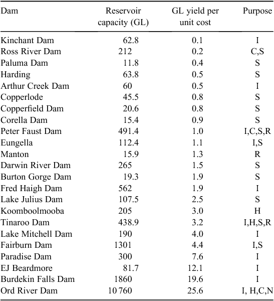
In each AWRC river basin, the more ‘promising’ potential dam sites were identified based on a minimum YpUCmax threshold, broad-scale geological suitability, and proximity to land suitable for irrigated agriculture. Four ‘minimum’ thresholds of YpUCmax were assessed: 2, 5, 10 and 20. However, in reporting an area that could potentially be irrigated, a threshold of YpUCmax ≥5 was adopted. This threshold value was based on previous experience of using the DamSite model and the more promising dam sites in the Flinders and Gilbert catchments (Petheram et al. 2013a), the Finniss and Adelaide River catchments (Petheram et al. 2017), and existing dams used for irrigation supply in northern Australia (Table 1). Table 1 lists existing large dams in northern Australia of capacity >10 GL, with their YpUC, where cost was calculated using the DamSite model yield and cost algorithm based on the listed ANCOLD dam dimensions. In reality, large-dam-based irrigation developments have been found to give a poor return on investment (e.g. Davidson 1972; Fan et al. 2007; Molle 2008; Kim et al. 2013; Poulton et al. 2013; Petheram et al. 2016), so any threshold value could be considered subjective.
|
A desktop geological inspection of the ‘better’ potential dam sites was undertaken by using available digital geological maps (typically 1 : 250 000 scale) and Google Earth. Those sites identified as having a high likelihood of serious geological problems (e.g. based on the broad-scale geological consideration listed above under Geology and soils) were excluded from further analysis. Unless the potential dams were small in volume in relation to the annual streamflow in the river, only the largest dam was selected along each river reach. In the few cases where multiple potential dams were located in series (i.e. one after the other), inflows to the downstream dam were reduced accordingly.
Step 3. Land suitability analysis
Land suitability is the fitness of a given area for a land utilisation type, commonly expressed as a set of discrete classes numbered from Class 1 (completely suited) to Class 5 (completely unsuited), as defined in Table 2. These classes are based on their inherent properties and ability to support a given agricultural enterprise cost-effectively. Note that a large proportion of Australia’s agricultural soils are categorised as Class 3 (moderately suitable with considerable limitations).

|
The land-suitability assessment used in this paper (Fig. 4) was for irrigated annual crops and was generated by using a generic set of rules (Wilson et al. 2009) across the entire study area and, hence, may not adequately consider local agronomy or local differences in soil properties. Although the best available data for each recorded soil type in each mapped area have been assessed, often these data represent only the dominant recorded soil and do not take into account other unmapped soils or local variations. Soil descriptions are usually constructed as typical of a soil type, based on a limited number of field-survey observations over large geographic areas. This may therefore lead to an over- or under-estimate of the likely limitations to agricultural development and management at specific locations. This soil suitability assessment does not consider other land and site factors such as flooding and salinity risk, water availability, economic and social considerations, or environmental offsite impacts. These factors are not usually considered in regional-scale land-suitability analysis because the information required is rarely meaningfully available at the regional scale. Furthermore, in the context of this analysis, the impacts of flooding are reduced by large dams, the extent to which can only be assessed by using detailed site-specific hydrological models. Nonetheless, in the majority of catchments, land suitable for irrigation was not limiting, and there would be potential to mitigate the risks such as flooding by developing land further from the river channel, although this would incur higher capital costs from the construction of additional pumping and conveyance infrastructure.

|
Figure 4 shows the mapped suitability for irrigated annual crops across northern Australia. Each mapped polygon is represented by the proportion of soil within that polygon that has been individually assessed in each suitability class. For example, an area mapped as A1 has >70% of the described soil within that area assessed as Class 1 or Class 2. Note that where only the dominant soil has been assessed, this may distort the mapping because the dominant soil may represent only 50%, or even less, of the total area. The mapped suitability groups indicate the proportion of different suitability classes that fall within a polygon.
Large, contiguous areas of land potentially suitable for irrigated annuals occur in the Pilbara, Riverless, Fitzroy (WA), Ord–Bonaparte, Daly, South-West Gulf, South-East Gulf and Western Cape regions (Fig. 4). It should be stressed that the large, contiguous nature of these areas may reflect the broad scale of the input soils data, and that finer scales of assessment would show the true nature of soil suitability and availability.
Although limited soil data exist for the southern half of the Northern Territory, they have yet to be compiled in a nationally compatible form and so could not be included in this assessment. Large, contiguous areas of soil suitable for irrigated agriculture are considered likely in this area, but as in the Riverless region, this area is likely to have very few suitable dam sites owing to the lack of suitable topography, high net evaporation, low runoff and generally unsuitable foundation conditions. Thus, the absence of land suitability data for these regions is unimportant for the purposes of this scale of analysis.
Step 4. Scale of northern Australia’s irrigation potential
The amount of land (ha) that could be potentially irrigated (APot) in each of the 100 AWRC river basins in northern Australia will be a function of the amount of water that can be reliably supplied from a reservoir or reservoirs, conveyance and application efficiency, and irrigation-water requirement. This can be represented by Eqn 1:

where YPot (GL) is the yield of a potential dam; E% (dimensionless) is the efficiency of delivery and application of water to the crop; IWR (mm) is an estimate of the irrigation water requirement (this does not include field application losses, which are encapsulated in E%); and C is a unit conversion factor, equal to 100 000. YPot was calculated by the method described previously in Step 1 (Dam location and yield estimation); methods for calculation of E% and IWR are described in the following two subsections.
Efficiency of delivery and application (E%)
All reservoir yields are expressed at the ‘dam wall’. The amount of water that could actually be used by irrigated crops will be considerably less than this amount, depending upon the distance of the dam to the irrigation scheme, the method of conveyance, on-farm storage and the technology used to apply water to the crop.
The overall efficiency of a system (E%) is defined here as the ratio of the volume of water used by the crops and evaporated from the soil surface to the volume of water that is released from the dam. (Note that some studies, e.g. Petheram et al. 2010, also include a storage efficiency term, but in this analysis, this is already encapsulated in the reservoir yield estimates.) E% is the product of the river-system conveyance efficiency (ET), irrigation-scheme conveyance efficiency (EC), within scheme/on-farm distribution efficiency (EF) and field-application efficiency (EA) (Eqn 2):

In the absence of other information, ET and EC were estimated by using modelled losses from four regulated catchments in central and northern Queensland (Petheram et al. 2013b) and a review of loss information in Australia (Petheram et al. 2010, 2013b). ET is estimated thus (Eqn 3a–c):


where DR is the distance water needs to be conveyed along the river from the dam wall to the irrigation area (re-regulating structure or point of extraction). EC is calculated according to Eqn 4:

where DC is the distance water needs to be conveyed along a constructed ‘trunk’ channel from the river to the irrigation scheme. Because of the poor resolution of soil data in many regions, the trunk channel was typically assumed to be 10 km in length.
The median (maximum) river and channel conveyance lengths estimated as part of this study were, respectively, 30 km (130 km) and 10 km (30 km). Figure 5a shows the percentage exceedance of river (left) and channel (right) conveyance efficiencies for potential dams with YpUCmax >2, 5, 10 and 20 GL per unit cost (UC). From this figure, it can be seen that 80% of the potential dam sites with YpUCmax threshold 2 (n = 125) have modelled river and channel conveyance efficiencies ≥80% and 88%, respectively.

|
Relatively high (i.e. ‘favourable’) efficiency values for EF and EA, 90% and 85%, respectively, were uniformly applied. An EA value of ~85% is typically achieved by using spray irrigation or well-managed surface irrigation with tail-water recycling on heavy soils (Petheram et al. 2010, 2013a, 2013b).
The median E% for potential dams where the YpUCmax was >2, 5, 10 and 20 GL per UC was 59%, 59%, 56% and 52%, respectively.
Irrigation water requirement (IWR)
The IWR is the rainfall-depth equivalent of water required by a crop to achieve its agronomic potential after rainfall (i.e. it does not include field-application losses).
In this analysis, IWR was calculated at a monthly time-step and it was assumed that no soil water was carried over from one month to the next. One of the underlying assumptions of this approach is that there is no net change in soil water at the monthly time-step. This assumption is considered reasonable for irrigated soils because the soil profile is usually kept wet. Because an EA value of 85% was used, leaching was assumed to occur most of the time, and hence, IWR values were not adjusted for leaching fractions as once commonly recommended in the literature (e.g. Ayers and Westcott 1985).
The simplest way of computing irrigation demand is to subtract precipitation (P) from the crop water requirement (ET). However, irrigated agriculture is inefficient in using rainfall because the soil profile is usually kept wet (Stirzaker 1999). To compensate for deep drainage, tail-water drainage and surface runoff, which may occur because of poor timing of rainfall and irrigation application, a rainfall efficiency term (EP) was introduced. The efficiency with which crops use rainfall (EP) will vary depending on a wide range of factors including soil type, irrigation management and local climate. In this broad-scale analysis, a uniform value of 0.8 was used.
In this analysis, monthly IWR was calculated as follows (Eqn 5a, b):


The subscript ‘m’ denotes the analysis was undertaken on a monthly time-step. Monthly values were summed to give annual values, and this process was repeated for the 77 years between 1930 and 2007. A mean IWR value was then calculated.
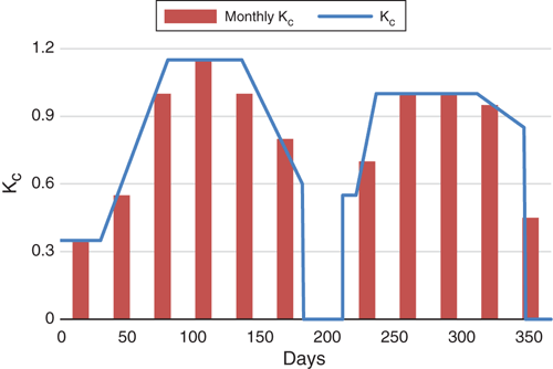
The ET was calculated by using reference evapotranspiration (E0) as calculated by the Penman–Monteith equation, as recommended by FAO Irrigation and Drainage Paper 56 (Allen et al. 1998) and weighted monthly crop factors (Kc) as shown in Fig. 6. Weighted monthly Kc values were calculated by using daily Kc values and length of crop-development stages provided by Allen et al. (1998). For northern Australia, the crop factors presented in Fig. 6 are nominally representative of a crop (e.g. cotton) planted during the early wet season and harvested in June–early July, with a second crop (e.g. a forage or soybean or mungbean) planted in early August and harvested or final cuts made in early December before the commencement of wet-season rains. It should be noted, however, that there is limited experience in double-cropping systems in northern Australia, and it is likely that implementing rotations such as this in areas with heavier soils will be challenging because of trafficability issues in planting of the first crop. Rainfall and ET0 data were obtained from the SILO Patched Point Dataset (Jeffrey et al. 2001) for 123 stations with higher quality climate data across Australia, and IWR was calculated for each station.
|
The results using the Kc values outlined in Fig. 6 are similar (<5% difference) to those if a uniform Kc of 0.8 is applied to E0 each month. A uniform Kc of 0.8 could be considered representative of a mixture of different broadacre crops, pastures and tree crops being grown simultaneously in an area, where the Kc of the plants will be <0.8 during their establishment phase, but their Kc will be >0.8 when they achieve full canopy cover. IWR values expressed in ML ha–1 for 123 centres across Australia are shown in Fig. 7. The same Kc values were applied to E0 data for southern Australia to enable comparison of the evaporative demands between southern and northern Australia. The results presented in Fig. 7 for northern Australia compare favourably with reported studies and with area-weighted water-use estimates for sugarcane assuming one-fifth under plant crop, three-fifths under ratoon and one-fifth under fallow (e.g. Holden and Sutherland 1998; Petheram et al. 2013b, 2013c; Ash et al. 2018a, 2018b, 2018c; Petheram et al. 2018).

|
It is important to note that actual irrigation application can sometimes be less than the IWR because the amount of water applied to attain an economic optimum is less than required to attain the agronomic optimum, for example, where supplementary irrigation of pasture occurs.
Broad estimates of the amount of land that could potentially be irrigated (APot)
Broad estimates of APot in each region were based on the coincidence of potential dam sites and land suitable for irrigation (using only those sites with a YpUCmax equal to or greater than the selected threshold), and the more limiting of these two factors. The irrigated annual land suitability map (see Land suitability analysis section above) was used to assess the scale and proximity of soils suitable for irrigated agriculture downstream, and in the vicinity, of the potential dam sites identified earlier. This process is illustrated for the Port Hedland Coast and De Grey River Basins below.
In this example, potential dam sites with YpUCmax ≥2 are shown. Figure 8 shows the potential dam sites overlain on a broad-scale geology map (Fig. 8a) and land suitability map (Fig. 8a).

|
Table 3 provides a regional-scale geological assessment of the more promising potential dam sites in the Port Hedland Coast and De Grey River Basins. Site F was deemed geologically unsuitable for a large dam and was excluded from the analysis.

|
Table 4 shows the assumptions used to calculate the area of land that could potentially be irrigated by dams located at sites A–E. Based on these data, the total area that could potentially be irrigated in the Port Hedland Coast River Basin (A and B) and the De Grey River Basin (C to E) by using water from potential dams with a minimum YpUCmax ≥2 is 10 827 ha and 24 586 ha, respectively. In both catchments, the area of land that could potentially be irrigated was water-limited.

|
Results
Modelled potential dam sites across northern Australia
Topographically favourable dam sites: an analysis of maximum storage volume per unit cost (VpUCmax)
A promising large-dam site depends on the existence of a physiographic constriction of the river channel immediately downstream of a broad voluminous valley, the dimensions of which determine the storage volume. Figure 9 displays the maximum ratio of reservoir volume to cost of construction (also referred to as the maximum volume per unit cost of construction, VpUCmax) at each site and for all potential dam sites in northern Australia with a ratio of storage per unit cost >20. VpUCmax gives an indication of those parts of northern Australia that have favourable topography for dams, and it can be used to identify suitable sites for large, off-stream storages.

|
Figure 9 indicates that the best topography for large dams is in the western half of northern Australia, in particular the Fitzroy (WA), Ord–Bonaparte and Roper regions. The full supply level (FSL) at which VpUCmax occurs in these regions is generally >50 m above the riverbed (see top inset Fig. 9). With the exception of the Roper region, river basins draining into the Gulf of Carpentaria generally have less favourable topography for siting large dams.
Elsewhere in northern Australia, parts of the Pilbara region and Burdekin catchment have favourable topography for storing water. The FSL at which VpUCmax occurs in these regions is ~20–40 m above the riverbed. The steep and rugged terrain of the Wet Tropics region has few sites that are topographically suitable for large dams. This is because high dam walls on steep narrow valleys are expensive and do not impound large volumes of water.
Despite the lack of relief, the results in Fig. 9 indicate (counterintuitively) that the upper Wiso–Barkly region has suitable topography for large storages. This is because dam walls that are long (i.e. >15 km) and low (<10 m height) could create impoundments that store very large volumes of water; the landscape is so flat that the impounded area would extend a long distance (e.g. >80 km in some instances). In addition, based on the dam-cost algorithm used, these low dams are relatively cheap (i.e. it is cheaper to double the width of a dam than double the height). However, these shallow, sandy storages would lose excessive water to evaporation and seepage, and runoff is very low (i.e. <15 mm year–1) and highly variable. Consequently, when inflows and net evaporation are taken into consideration, these sites are not promising in terms of YpUCmax (Fig. 10).

|
Topographically and hydro-climatically favourable dam sites: an analysis of maximum yield per unit cost (YpUCmax) and maximum yield
In addition to having suitable topography and geology, dams require sufficient inflows to meet a potential demand (e.g. from a town, an irrigation district or mine), and in those areas where evaporation greatly exceeds rainfall, they cannot be so shallow that large amounts of water are lost to evaporation and seepage. Dams that command smaller catchments with lower runoff have smaller yields. The results presented in Fig. 10 take into consideration dam and reservoir dimensions, and also the quantity and variability of inflows to the reservoir and net evaporation from the reservoir. Only those sites with YpUCmax ≥5 are displayed.
In terms of YpUCmax, the better potential dam locations occur in the western half of northern Australia, where there are topographically favourable potential dam sites with large catchment areas (i.e. large inflows), such as the Fitzroy region. Other locations with large YpUCmax are the wetter, more northerly Van Diemen and Western Cape regions. Although these regions have only moderately favourable topography for dams (Fig. 9), they have large and relatively reliable inflows. However, the western half of much of the Western Cape region is underlain by bauxite, which is highly permeable and generally unsuitable for water storages.
The best large potential dam sites in northern Australia (i.e. yield >1500 GL) in terms of YpUCmax are in the lower Daly (Mount Nancar), the lower Victoria and the lower Roper River Basins. However, unlike the existing Ord River and Burdekin Falls Dams, limited areas of land appear suitable for irrigated agriculture below these potential dam sites.
In terms of YpUCmax, other potential dam locations of note occur along the Burdekin River upstream of the existing Burdekin Falls Dam (e.g. Hells Gates Mount Foxton), the Fitzroy catchment (WA) (e.g. Dimond Gorge) and the Herbert River Gorge in the Wet Tropics region.
Unlike the catchments in the Timor Sea and Gulf of Carpentaria Drainage Division and the Pilbara region, DamSite modelling of the Queensland coastal catchments indicated weir structures to be generally the most cost-effective form of water storage. This is probably because the large, easterly draining rivers are more deeply incised than the rivers in northern Australia west of the Great Dividing Range. Incised rivers can enable modest storage of water (e.g. 5–20 GL) behind relatively narrow (i.e. 100–200 m), ~10-m-high weir structures. Furthermore, unlike most of the rivers west of the Divide, many of the large, east-draining rivers flow for a large proportion of the year, which has the effect of continually replenishing the weir reservoir.
The regions in the Gulf, which are topographically relatively unfavourable for large dams, are even less favourable in terms YpUCmax (Fig. 10) because many of these areas also have low runoff relative to the rest of northern Australia (Fig. 3).
In the westerly Fitzroy (WA), Kimberley and Ord–Bonapatre regions, the FSL corresponding to YpUCmax for many of the better locations is ~30–50 m above the riverbed. These same locations had an optimal FSL >50 m in terms of storage per unit cost, which indicates that, although larger dams could be constructed at many of these sites, their performance starts to be limited by inflows to the dam reservoir. In the Gilbert and Mitchell River Basins in the Gulf of Carpentaria Drainage Division, there are several potential dam sites where the FSL corresponding to YpUCmax is 30–40 m above the riverbed. In the northerly regions, such as Van Diemen, Arafura and Western Cape, the height of the FSL at YpUCmax is typically <20 m, largely a reflection of the subdued topography.
Figure 10 shows that large parts of northern Australia comprise Indigenous land or have been set aside for conservation or other protection (e.g. nature parks, flora, historical and coastal reserves, state conservation areas, nature refuges and heritage agreements). Some of the better potential dam sites in terms of VpUCmax, but also YpUCmax, occur in these areas. Many conservation areas are located in quite rugged landscapes with a limited number of other uses, and these landscapes often have locations topographically favourable for siting dams.
Figure 11 shows the yield (at 85% annual time reliability) at the dam height at which YpUCmax occurs. Note that it is possible that a dam constructed at each site could have a higher or lower yield than displayed in the Figure if the dam wall was constructed higher (and the reservoir yield was not inflow-limited) or lower than the yield at the height of the dam wall at YpUCmax.

|
Potential area that could be irrigated
The amount of land that could potentially be irrigated in each AWRC river basin based on the coincidence of land suitable for irrigated agriculture and large dams with YpUCmax ≥2, 5, 10 and 20 (using the methods outlined above in Scale of northern Australia’s irrigation potential) is shown in Fig. 12.

|
This analysis does not take into consideration the risk of flooding or secondary salinisation and it is unconstrained by social, environmental, economic and legislative considerations that would limit the upper physical limit estimates of dam and irrigation development presented here.
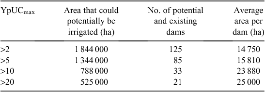
Across all of northern Australia, it was calculated that there were sufficient large-dam sites with a YpUCmax ≥2 coincident with soil suitable for irrigated agriculture to support ~1.84 Mha of irrigated agriculture (Table 5), i.e. an increase of nearly 1.7 Mha on the current 150 000 ha. Development of this area would require the building ~117 of the more viable large dams and the use of the full yield from eight existing large dams such as the Burdekin Falls and Ord River Dams. Approximately 55% of this area (~1 Mha of irrigated agriculture) could be irrigated from ~30 of the existing and most promising large dams with YpUCmax ≥2. Figure 13 plots the ranked cumulative area that could potentially be irrigated by increasing the number of dams (i.e. the dam that supports the largest area of irrigation first and that which supports the smallest area of irrigation last) if the minimum YpUCmax threshold was set at 2, 5, 10 and 20. Clearly, there are declining marginal returns to dam construction, in part because it is efficient to build the best dams first, but also because additional dams may in some places ‘compete’ for the same water supply.
|

|
Irrigation development in northern Australia within the context of Australia
In 2012–13, it was estimated that ~2.4 Mha of irrigated land existed in Australia, of which 1.2 Mha was situated in the Murray–Darling Basin (ABS 2014). In northern Australia, an estimated ~150 000 ha of land is irrigated (excluding those parts of the Emerald irrigation area in the Fitzroy catchment (Qld) just south of the Tropic of Capricorn), or ~6% of Australia’s irrigated area. This study estimated that increasing the area under irrigation in northern Australia to 1.34 Mha (assuming that only dams with YpUCmax >5 were considered) would result in a ~50% increase in Australia’s total irrigated area. This is consistent with the finding of Petheram et al. (2010), who estimated that northern Australia could support ~38% of Australia’s potentially irrigable area (unconstrained by social, environmental, economic or legislative considerations or the availability and proximity of land suitable for irrigation). To irrigate an area of 1.34 Mha in northern Australia would require the controlled release of ~21 500 GL of water from reservoirs in the north. This is equivalent to ~30% of the water that was extracted from all of the rivers/dams in Australia in 2000–01 (~75 000 GL), of which two-thirds (i.e. ~50 000 GL) was returned to river, mainly after use for hydroelectric power generation, and one-third (~25 000 GL) was consumed by cities, industry, households and agriculture (CSIRO 2011). In comparing the areas that could physically be irrigated in northern and southern Australia, it should be noted that at the time of dam and irrigation development in many parts of southern Australia (i.e. 1950s to 1980s), community values, legalisation and economic paradigms were very different from today. Furthermore, dam and irrigation development in northern Australia would need to comply with some legislation that is largely unique to the north (e.g. land tenure, Reef Water Quality).
Discussion
To the authors’ knowledge, this study is the first consistent and objective assessment of individual dam sites and their potential for irrigation across an area of this scale. Over 100 billion calculations of dam and reservoir dimension and yield were undertaken across an area of 3 million km2, and the entire analysis was completed in a period of less than 2 months. Because the SRTM was captured globally, the methods outlined in this paper could potentially be applied anywhere in the world. However, in places where there is not a higher resolution and more accurate DEM than the SRTM, the SRTM would require processing to remove striping and vegetation and enforce drainage as was done for Australia to create DEM-H (Gallant et al. 2011). An assessment of areas of land that could potentially be irrigated would be contingent upon regional-scale land suitability data being available.
The results of this study have been used to guide government priorities for investment and in planning studies to acquire more detailed bio-physical information to support investment and regulatory decisions (PMC 2015). This paper also provides several upper limits on irrigation development depending on the appetite of government to invest in infrastructure development in northern Australia. Under the least financially attractive of the options explored (i.e. 2 GL per unit cost), ~1.84 Mha of land could potentially be irrigated using water from 125 large dams (Table 5); however, these dams yielded water at a unit cost considerably lower than is likely to be politically palatable based on current public discourse. A more palatable, but still financially unattractive, option under current economic evaluation methods is the threshold of 5 GL per unit cost, for which 1.34 Mha of land suitable for irrigation could potentially be irrigated using water from 85 large dams. The Dagworth Dam in the Gilbert catchment was calculated by the DamSite model to have a YpUCmax of 8. However, in a detailed hydro-agroeconomic analysis, Poulton et al. (2013) were unable to identify any conditions under which a positive internal rate of return could be attained, except where a high price for sugarcane was sustained over the entire 30-year investment period, and this resulted in an internal rate of return of only ~1% (i.e. less than long-term inflation).
If the amount of land under irrigation in northern Australia increased to 1.34 Mha, then ~37% of Australia’s irrigated land would be north of the Tropic of Capricorn. This percentage is remarkably similar to that calculated by Petheram et al. (2010), the only other study that has sought to provide a continental assessment of Australia’s potential for irrigation. Ignoring soil data and using only broad-scale water datasets, Petheram et al. (2010) estimated that northern Australia has ~38% of Australia’s potentially irrigable area (unconstrained by social, environmental, economic or legislative considerations) and concluded that, whereas there are opportunities for irrigation in northern Australia, the majority of Australia’s irrigation would always be located in the south. This study further supports this assertion.
The main technical limitations to this assessment of the potential for large dams and irrigation in northern Australia were associated with: (i) the scale and quality of the best available DEM; (ii) the lack of on-ground geological assessment; and (iii) the broad scale of the land-suitability mapping. Although this assessment did not assume a given regulatory environment, the authors recognise that in reality, the current legal and regulatory environment, which varies across the three northern jurisdictions, will considerably constrain dam and irrigation development across northern Australia, and that these can change with time. The potential areas of development being discussed here therefore represent likely upper limits based on physical considerations. This study represents a major advance on the methods applied by Petheram et al. (2010), and the authors have not identified any comparable study in the international literature.
Although this paper focused on large, in-stream dams, some parts of northern Australia may lend themselves to extracting water from groundwater, water-harvesting and off-stream storage of water, and managed aquifer recharge. In some cases, there may also be opportunities to augment and extract water from natural waterholes and wetlands to supply farm-scale irrigation developments. Of these alternative sources of water, only for groundwater has it been estimated how much land could potentially be irrigated in northern Australia. Here, Turnadge et al. (2013) extended the analysis of Cresswell et al. (2009) to the Tropic of Capricorn and estimated that groundwater could potentially support 100 000–150 000 ha of irrigated land in northern Australia. This is ~10% of the land that could physically be irrigated by using large dams in northern Australia, and this value is comparable to the ratio of groundwater and surface water usage in southern Australia (CSIRO 2011). Although the potential to use other sources of water for irrigation has not been quantified, each of these approaches is likely to be physically capable of supplying far smaller (i.e. 5–100 times lower) volumes of water than large, in-stream dams.
Nevertheless, each water source may have a role to play in maximising the cost-effectiveness of water supply in a given location, and/or enable locally specific irrigation methods to be learnt at a small scale before undertaking large capital investments. Furthermore, the proportion of land that may eventually be irrigated by using other sources of water may be larger than stated above if social, environmental, economic and legislative factors, which will inevitably constrain water and agricultural development in northern Australia, are realised. As with large dams, the development of these water-supply options would require trade-offs with other users of the water and the environment.
Conclusions
This analysis indicates that opportunities for irrigation development across northern Australia are not evenly distributed and that surface-water storage potential is generally more limiting than land suitable for irrigation. Higher yielding potential dam sites are generally located in the north-western half of the study area (i.e. the Timor Sea Drainage Division), where the topography is more favourable for large dams in the mid-reaches. In the north-eastern half of the study area (i.e. Gulf of Carpentaria), favourable topography for dams is generally limited to the upper reaches of catchments, where dam catchment areas are relatively small and rainfall is often relatively low. In the semi-arid and arid southerly regions, there are very limited opportunities for large dams. Most, but not all, catchments across northern Australia were deemed water-limited.
Physical resources (soil, surface water and potential large in-stream dams) sufficient to support 1.34 Mha of irrigated agriculture exist in northern Australia. Development of this area would require ~85 of the more viable large dams (including the Burdekin Falls and Ord River Dams, which are already constructed) and a large number of reregulating structures (e.g. weirs). Approximately 50% of this area (~650 000 ha) could be irrigated with ~25% (20) of the more promising large dams in northern Australia. Clearly, applying consistent and repeatable physical criteria to dam prioritisation could significantly increase the cost-effectiveness of dam selection and construction.
New dam and irrigation developments in northern Australia would need to comply with a variety of state, national and international legislation that did not exist at the time of dam and irrigation development in the south, as well as complying with some legislation that is largely unique to northern Australia (e.g. land tenure and Reef Water Quality). In reality, these legislative controls and social norms, both of which change with time, will limit the upper estimates of dam and irrigation development stated in this paper.
Consequently, although alternative sources of water (e.g. groundwater, wetlands, natural waterholes) and water storage (e.g. gully dams, ringtanks, managed aquifer recharge) may be able to contribute only ~20–30% of the irrigation area physically possible using large dams, the proportion of irrigated land that may eventually be realised by using these alternative sources of water may be higher once social, environmental, economic and legislative factors are realised.
Conflicts of interest
The authors declare no conflicts of interest.
Acknowledgements
The authors thank Dr Ian Watson (CSIRO), Dr Andrew Ash (CSIRO) and two anonymous reviewers for their helpful review comments. Major funding for the original analysis was provided by the Office of Northern Australia and the Australian Government’s Northern Australia Sustainable Futures program.
References
ABS (2014). 4618ODO001_201213 Water use on Australian Farms – 2012-13. Available at: http://www.abs.gov.au/AUSSTATS/abs@.nsf/DetailsPage/4618.02012-13 (accessed 10 January 2014).Allen, R. G., Pereira, L. S., Raes, D., and Smith, M. (1998). ‘Crop Evapotranspiration—Guidelines for Computing Crop Water Requirements.’ FAO Irrigation and Drainage Paper 56. (Food and Agriculture Organization of the United Nations: Rome.)
ANCOLD (2010). Register of large dams in Australia, 2010. Australian National Committee on Large Dams, Hobart, Tas. Available at: https://www.ancold.org.au/?page_id=24 (accessed 20 October 2011).
Ash, A., Bristow, M., Laing, A., MacLeod, N., Niscioli, A., Paini, D., Palmer, J., Prestwidge, D., Stokes, C., Watson, I., Webster, T., and Yeates, S. (2018a). Agricultural viability: Darwin catchments. A technical report to the Australian Government from the CSIRO Northern Australia Water Resource Assessment, part of the National Water Infrastructure Development Fund, Water Resource Assessments. CSIRO, Australia. Available at: https://publications.csiro.au/rpr/pub?pid=csiro:EP186191 (accessed 11 September 2018).
Ash, A., Cossart, R., Ham, C., Laing, A., MacLeod, N., Paini, D., Palmer, J., Poulton, P., Prestwidge, D., Stokes, C., Watson, I., Webster, T., and Yeates, S. (2018b). Agricultural viability: Fitzroy catchment. A technical report to the Australian Government from the CSIRO Northern Australia Water Resource Assessment, part of the National Water Infrastructure Development Fund, Water Resource Assessments. CSIRO, Australia. Available at: https://publications.csiro.au/rpr/pub?pid=csiro:EP186200 (accessed 11 September 2018).
Ash, A., Laing, A., MacLeod, N., Paini, D., Palmer, J., Poulton, P., Prestwidge, D., Stokes, C., Watson, I., Webster, T., and Yeates, S. (2018c). Agricultural viability: Mitchell catchment. A technical report to the Australian Government from the CSIRO Northern Australia Water Resource Assessment, part of the National Water Infrastructure Development Fund, Water Resource Assessments. CSIRO, Australia. Available at: https://publications.csiro.au/rpr/pub?pid=csiro:EP186198 (accessed 11 September 2018).
AWRC (1976). ‘Review of Australia’s Water Resources 1975.’ Department of National Resources. Australian Water Resources Council. (Australian Government Publishing Service: Canberra, ACT.)
AWRC (1988). ‘1985 Review of Australia’s Water Resources and Water Use. Vol. 1: Water Resources Data Set.’ Australian Water Resources Council. (Australian Government Publishing Service: Canberra, ACT.)
Ayers, R. S., and Westcott, D. W. (1985). ‘Water Quality for Agriculture, Irrigation and Drainage. Paper 29 Rev 1. (Food and Agriculture Organization of the United Nations: Rome.)
Cresswell, R., Petheram, C., Harrington, G., Buettikofer, H., Hodgen, M., Davies, P., and Li, L. (2009). Water resources in northern Australia 01. Northern Australia Land and Water Science Review. CSIRO Land and Water, Canberra, ACT.
CSIRO (2009a). Northern Australia Land and Water Science Review. A report to the Northern Australia Land and Water Taskforce. CSIRO, Australia.
CSIRO (2009b). Water in the Gulf of Carpentaria Drainage Division. A report to the Australian Government from the CSIRO Northern Australia Sustainable Yields Project. CSIRO Water for a Healthy Country Flagship, Australia.
CSIRO (2009c). Water in the Timor Sea Drainage Division. A report to the Australian Government from the CSIRO Northern Australia Sustainable Yields Project. CSIRO Water for a Healthy Country Flagship, Australia.
CSIRO (2009d). Water in the Northern North-East Coast Drainage Division. A report to the Australian Government from the CSIRO Northern Australia Sustainable Yields Project. CSIRO Water for a Healthy Country Flagship, Australia.
CSIRO (2011). ‘Water: Science and Solutions for Australia.’ (Ed. I. P. Prosser.) (CSIRO Publishing: Melbourne.)
Davidson, B. (1972). ‘The Northern Myth: Limits to Agricultural and Pastoral Development in Tropical Australia.’ 3rd edn. (Melbourne University Press: Melbourne.)
Fan, S., Brzeska, J., and Shields, G. (2007). ‘Investment Priorities for Economic Growth and Poverty Reduction, 2020 Focus Brief on the World’s Poor and Hungry People.’ (International Food Policy Research Institute: Washington, DC, USA.)
Gallant, J. C., Dowling, T. I., Read, A. M., Wilson, N., Tickle, P. K., and Inskeep, C. (2011). 1 second SRTM-derived Digital Elevation Models User Guide. Geoscience Australia, Canberra, ACT. Available at: www.ga.gov.au/topographic-mapping/digital-elevation-data.html
Holden, J. R., and Sutherland, P. J. (1998) Assessing the effects of green cane trash blankets on furrow irrigation efficiencies and irrigation scheduling of sugarcane in the Burdekin district of north Queensland. In: ‘International Irrigation Association Technical Conference’. San Diego, CA, USA. (Irrigation Association: Fairfax, VA, USA.)
Jeffrey, S. J., Carter, J. O., Moodie, K. B., and Beswick, A. R. (2001). Using spatial interpolation to construct a comprehensive archive of Australian climate data. Environmental Modelling & Software 16, 309–330.
| Using spatial interpolation to construct a comprehensive archive of Australian climate data.Crossref | GoogleScholarGoogle Scholar |
Kim, S., Petheram, C., Hornbuckle, J., Holz, L., Kehoe, M., Podger, S., Aramini, D., Wilson, P., McJannet, D., Read, A., Munday, T., Davis, A., Poulton, P., Rassam, D., Waltham, N., Burrows, D., Hughes, J., Brennan McKellar, L., Podger, G., Philip, S., Barber, M., and Schmidt, R. K. (2013). O’Connell Creek off-stream storage and irrigated rice. Agricultural resource assessment for the Flinders Catchment. Ch. 9. A report to the Australian Government from the CSIRO Flinders and Gilbert Agricultural Resource Assessment, part of the North Queensland Irrigated Agriculture Strategy. (Eds C. Petheram, I. Watson and P. Stone.) CSIRO Water for a Healthy Country and Sustainable Agriculture Flagship, Australia. Available at: https://publications.csiro.au/rpr/pub?list=SEA&pid=csiro:EP142877
McMahon, T. A., and Adeloye, A. J. (2005). ‘Water Resources Yield.’ (Water Resources Publications: Highlands Ranch, CO, USA.)
Molle, F. (2008). Why enough is never enough: The societal determinants of river basin closure. International Journal of Water Resources Development 24, 217–226.
| Why enough is never enough: The societal determinants of river basin closure.Crossref | GoogleScholarGoogle Scholar |
NLWRA (2000). Australian water resources assessment 2000. National Land and Water Resources Audit, Australia. Available at: http://audit.ea.gov.au/anra/water/docs/national/Water_Contents.html (accessed 12 February 2006).
Petheram, C., McMahon, T. A., and Peel, M. C. (2008). Flow characteristics of rivers in northern Australia: Implications for development. Journal of Hydrology 357, 93–111.
| Flow characteristics of rivers in northern Australia: Implications for development.Crossref | GoogleScholarGoogle Scholar |
Petheram, C., Rustomji, P., and Vleeshouwer, J. (2009). Rainfall–runoff modelling across northern Australia. A report to the Australian Government from the CSIRO Northern Australian Sustainable Yields Project. CSIRO Water for a Healthy Country Flagship, Australia. Available at: https://publications.csiro.au/rpr/pub?pid=csiro:EP113491
Petheram, C., McMahon, T. A., Peel, M. C., and Smith, C. J. (2010). A continental scale assessment of Australia’s potential for irrigation. Water Resources Management 24, 1791–1817.
| A continental scale assessment of Australia’s potential for irrigation.Crossref | GoogleScholarGoogle Scholar |
Petheram, C., Rustomji, P., McVicar, T. R., Cai, W., Chiew, F. H. S., Vleeshouwer, J., Van Niel, T. G., Li, L., Cresswell, R. G., Donohue, R. J., Teng, J., and Perraud, J.-M. (2012). Estimating the impact of projected climate change on runoff across the tropical savannas and semiarid rangelands of northern Australia. Journal of Hydrometeorology 13, 483–503.
| Estimating the impact of projected climate change on runoff across the tropical savannas and semiarid rangelands of northern Australia.Crossref | GoogleScholarGoogle Scholar |
Petheram, C., Rogers, L., Eades, G., Marvanek, S., Gallant, J., Read, A., Sherman, B., Yang, A., Waltham, N., McIntyre-Tamwoy, S., Burrows, D., Kim, S., Podger, S., Tomkins, K., Poulton, P., Holz, L., Bird, M., Atkinson, F., Gallant, S., and Kehoe, M. (2013a). Assessment of surface water storage options in the Flinders and Gilbert catchments. A technical report to the Australian Government from the CSIRO Flinders and Gilbert Agricultural Resource Assessment, part of the North Queensland Irrigated Agriculture Strategy. CSIRO Water for a Healthy Country and Sustainable Agriculture Flagship, Australia. Available at: https://publications.csiro.au/rpr/pub?pid=csiro:EP139850
Petheram, C., Webster, T., Poulton, P., Stone, P., Hornbuckle, J., Harms, B., Philip, S., Rogers, L., Eades, G., Brennan McKellar, L., Bartley, R., Holz, L., Kim, S., Schmidt, R. K., Wilson, P., Tomkins, K., Gallant, S., Marvanek, S., Buettikofer, H., and Wallbrink, A. (2013b). Opportunities for irrigation in the Flinders catchment. Agricultural Resource Assessment for the Flinders Catchment. Ch. 5. A report to the Australian Government from the CSIRO Flinders and Gilbert Agricultural Resource Assessment, part of the North Queensland Irrigated Agriculture Strategy. (Eds C. Petheram, I. Watson and P. Stone.) CSIRO Water for a Healthy Country and Sustainable Agriculture Flagship, Australia. Available at: https://publications.csiro.au/rpr/pub?list=SEA&pid=csiro:EP142866
Petheram, C., Webster, T., Poulton, P., Stone, P., Hornbuckle, J., Harms, B., Philip, S., Rogers, L., Eades, G., Brennan McKellar, L., Bartley, R., Holz, L., Kim, S., Schmidt, R. K., Wilson, P., Tomkins, K., Gallant, S., Marvanek, S., Buettikofer, H., and Wallbrink, A. (2013c). Opportunities for irrigation in the Gilbert catchment. Agricultural Resource Assessment for the Gilbert Catchment. Ch. 5. A report to the Australian Government from the CSIRO Flinders and Gilbert Agricultural Resource Assessment, part of the North Queensland Irrigated Agriculture Strategy. (Eds C. Petheram, I. Watson and P. Stone.) CSIRO Water for a Healthy Country and Sustainable Agriculture Flagship, Australia. Available at: https://publications.csiro.au/rpr/pub?list=SEA&pid=csiro:EP143196
Petheram, C., Gallant, J., Wilson, P., Stone, P., Eades, G., Roger, L., Read, A., Tickell, S., Commander, P., Moon, A., McFarlane, D., and Marvanek, S. (2014). Northern rivers and dams: a preliminary assessment of surface water storage potential for northern Australia. Technical Report, CSIRO Land and Water Flagship, Australia. Available at: https://publications.csiro.au/rpr/pub?pid=csiro:EP147168
Petheram, C., Hughes, J., McKellar, L., Kim, S., Holz, L., Poulton, P., Kehoe, M., and Podger, Petheram, C., Hughes, J., McKellar, L., Kim, S., Holz, L., Poulton, P., Kehoe, M., and Podger, Petheram, C., Hughes, J., McKellar, L., Kim, S., Holz, L., Poulton, P., Kehoe, M., and Podger, (2016). A method for comprehensively assessing economic trade-offs of new irrigation developments. Water Resource Management 30, 4617–4634.
| A method for comprehensively assessing economic trade-offs of new irrigation developments.Crossref | GoogleScholarGoogle Scholar |
Petheram, C., Gallant, J., and Read, A. (2017). DamSite: An automated and rapid method for identifying dam wall locations. Environmental Modelling & Software 92, 189–201.
| DamSite: An automated and rapid method for identifying dam wall locations.Crossref | GoogleScholarGoogle Scholar |
Petheram, C., Hughes, J., Stokes, C., Watson, I., Irvin, S., Musson, D., Philip, S., Turnadge, C., Poulton, P., Rogers, L., Wilson, P., Pollino, C., Ash, A., Webster, T., Yeates, S., Chilcott, C., Bruce, C., Stratford, D., Taylor, A., Davies, P., and Higgins, A. (2018). Case studies for the Northern Australia Water Resource Assessment. A report to the Australian Government from the CSIRO Northern Australia Water Resource Assessment, part of the National Water Infrastructure Development Fund: Water Resource Assessments. CSIRO, Australia.
PMC (2015). Our North, Our Future: White Paper on Developing Northern Australia. Department of Prime Minister and Cabinet, Australian Government, Canberra. Available at: https://www.industry.gov.au/sites/g/files/net3906/f/June%202018/document/pdf/nawp-fullreport.pdf (accessed 9 September 2018).
Poulton, P., Bonnett, G., Webster, T., Podger, G., Petheram, C., Holz, L., Kim, S., Aramini, D., Kehoe, M., Podger, S., Wilson, P., McJannet, D., Hughes, J., Read, A., Rassam, D., Waltham, N., Burrows, D., Brennan McKellar, L., Hornbuckle, J., Philip, S., Higgins, A., Barber, M., Schmidt, R. K., and Wallbrink, A. (2013). Dagworth and Green Hills dams and irrigated sugarcane. Agricultural Resource Assessment for the Gilbert Catchment. Ch. 9. A report to the Australian Government from the CSIRO Flinders and Gilbert Agricultural Resource Assessment, part of the North Queensland Irrigated Agriculture Strategy. CSIRO Water for a Healthy Country and Sustainable Agriculture Flagship, Australia. Available at: https://publications.csiro.au/rpr/pub?list=SEA&pid=csiro:EP143221
Read, A., Gallant, J., and Petheram, C. (2012). DamSite: An automated method for the regional scale identification of dam wall locations. In: ‘34th Hydrology & Water Resources Symposium’. 19–22 November 2012, Sydney. (Engineers Australia: Canberra, ACT.)
Stirzaker, R. J. (1999). The problem of irrigated horticulture: matching the biophysical efficiency with the economic efficiency. Agroforestry Systems 45, 187–202.
| The problem of irrigated horticulture: matching the biophysical efficiency with the economic efficiency.Crossref | GoogleScholarGoogle Scholar |
Turnadge, C., Petheram, C., Davies, P., and Harrington, G. (2013). Water resources. Mosaic irrigation for the northern Australian beef industry. An Assessment of Sustainability and Potential. Ch. 3. A technical report prepared for the Office of Northern Australia. (Eds A. C. Grice, I. Watson and P. Stone.) (CSIRO, Australia.)
Vaze, J., Viney, N., Stenson, M., Renzullo, L., Van Dijk, A., Dutta, D., Crosbie, R., Lerat, J., Penton, D., Vleeshouwer, J., Peeters, L., Teng, J., Kim, S., Hughes, J., Dawes, W., Zhang, Y., Leighton, B., Perraud, J. M., Joehnk, K., Yang, A., Wang, B., Frost, A., Elmahd, A., Smith, A., and Daamen, C. (2013). The Australian Water Resource Assessment System (AWRA). In: ‘Proceedings 20th International Congress on Modelling and Simulation (MODSIM2013)’. 1–6 December 2013, Adelaide, S. Aust. (Modelling and Simulation Society of Australia and New Zealand.)
Wilson, P., Ringrose‐Voase, A., Jacquier, D., Gregory, L., Webb, M., Wong, M., Powell, B., Brough, D., Hill, J., Lynch, B., Schoknecht, N., and Griffin, T. (2009). Land and soil resources in northern Australia. Northern Australia Land and Water Science Review. Report coordinated by CSIRO to The Northern Australia Land and Water Taskforce, Canberra, ACT.