

Stocking density and distribution in relation to vegetation in a biodiverse semi-arid pastoral system in South Africa
M. Igshaan Samuels A B C * , Nicky Allsopp D and M. Timm Hoffman BA Agricultural Research Council – Animal Production, Biodiversity and Conservation Biology Department, University of the Western Cape, 7535, South Africa.
B Plant Conservation Unit, Department of Biological Sciences, University of Cape Town, 7701, South Africa.
C Biodiversity and Conservation Biology Department, University of the Western Cape, 7535, South Africa.
D South African Environmental Observation Network (SAEON), Fynbos Node, Claremont 7735, South Africa.
The Rangeland Journal 44(1) 1-12 https://doi.org/10.1071/RJ21046
Submitted: 18 August 2021 Accepted: 17 January 2022 Published: 7 March 2022
© 2022 The Author(s) (or their employer(s)). Published by CSIRO Publishing on behalf of the Australian Rangeland Society. This is an open access article distributed under the Creative Commons Attribution-NonCommercial-NoDerivatives 4.0 International License (CC BY-NC-ND)
Abstract
The spatial heterogeneity of vegetation in a communal grazing system provides pastoralists with a range of grazing sites to select for their livestock. When fencing spatially constrains herds, there is reduced access to ecological heterogeneity, which may have a negative impact on livestock and the grazing resource. This study investigated temporal and spatial changes in stocking densities and distribution within the six major vegetation types of the Leliefontein pastoral area in Namaqualand, South Africa. This semi-arid, biodiverse area of about 2000 km2 supports a spatially-constrained mobile pastoral system based on small stock production. Over the data period from 1999 to 2006, the location of 256 small stock herds, their temporal occupancy and herd size were used to determine stocking densities within the daily grazing radius of herds. These grazing radii were overlaid using GIS to produce stocking density distributions over the landscape. The density and location of herds were unevenly distributed when assessed monthly and annually. Parts of the study area were consistently overstocked whereas others remained ungrazed. We argue that the recommendation of fixed stocking rates within this variable environment is inappropriate because forage availability and quality fluctuate within and between years and within drought cycles. We conclude that development interventions should rather focus on reducing stocking densities during and after drought periods. This would benefit pastoralists through reduced livestock mortalities and the vegetation would recover more quickly from the impacts of drought.
Keywords: drought, grazing management, landscape ecology, livestock mobility, Namaqualand, overstocking, semiarid shrublands, spatial variation, stocking rate, Succulent Karoo.
Introduction
African rangelands are characterised by a mosaic of vegetation types over a range of spatial scales (Niamir 1991). Spatial heterogeneity of vegetation is affected by gradients in climate (O’Brien 1993; Scholes et al. 2009), soils (Anderson and Talbot 1965) and landscape variability (McCabe 1994). Land use (Esler et al. 2006) including grazing (Adler et al. 2001) also affects vegetation spatial heterogeneity at a range of scales. Grazing around watering points, livestock corrals and human settlements results in vegetation gradients, where the most palatable plants occur further away from livestock focal points (Adler et al. 2001; Riginos and Hoffman 2003; Todd 2006). Where long-term stocking rate is high, the vegetation in the winter rainfall Namaqualand region of South Africa has lower cover of perennial plants (Riginos and Hoffman 2003), higher abundance of unpalatable and toxic plants, and is dominated by annuals (Todd and Hoffman 1999, 2009). The heterogeneity and patchiness of vegetation thus create different grazing opportunities for livestock.
On many private livestock farms, particularly in South Africa, a range of strategies are used to manipulate livestock grazing pressure distribution on rangelands. These include fences, water point location, location of salt licks and other nutritional supplementation, and shade (Valentine 2000). Fences are often used to separate different vegetation units into paddocks to create homogenous vegetation landscapes. Ranchers usually try to rotate herds among paddocks and graze on a wider range of plants including less palatable species, so reducing selective grazing (Beukes and Cowling 2000).
In extensive, unfenced rangeland commons, pastoralists herd their livestock to areas most suitable for livestock in terms of terrain and forage composition. Livestock movement among different habitats is well studied (Low et al. 1981; Coppock et al. 1986; Scoones 1995; Bailey et al. 2004), and is considered a resilience strategy for making optimal use of variable grazing resources (Niamir-Fuller and Turner 1999; Schareika 2001). Furthermore, herding distributes livestock density (Behnke and Scoones 1993), reducing over and under grazing (Bassett 1986). To achieve these objectives, pastoralists must consider natural forage quality fluctuations within and between seasons and move livestock in accordance with these fluctuations. To move livestock appropriately, pastoralists thus need to know their local vegetation types and monitor forage resources to make informed herd management decisions (Schareika 2001). For example, herders in Niger have a nutritional programme for their cattle where they move animals to specific rangeland areas based on forage availability and quality during specific times of the year (Schareika 2001).
When pastoral areas are fenced off from other land units, herds become spatially constrained, reducing their access to the full range of vegetation in the landscape (Niamir-Fuller 1999). Pastoralists could also lose access to key resources (Scoones 1991) important for dry season survival of livestock (Illius and O’Connor 1999; Hempson 2010). In pastoral systems where there is a low input of external food sources, herders must maximise use of available natural resources to feed their animals.
Mobile pastoralists, particularly in Africa, are known to overnight their animals in corrals and erect their living and cooking shelters nearby to protect the herd against predation and theft. Collectively, these infrastructures are known as stockposts that are moved around in the rangeland for a variety of environmental, social and agricultural reasons (Samuels et al. 2008, 2019). This results in varying stocking densities within different vegetation types.
The aim of this study was to investigate the spatial distribution of stocking density of small stock in different vegetation types in relation to landscape features and drought in the Leliefontein pastoral area in South Africa. It discusses the implications of different stocking densities on vegetation and the applicability of a fixed stocking rate in the study area.
Methods
General description of the Nama and the study area
The area is about 192 000 ha, surrounded by private farms and farms redistributed to Nama people as part of the land reform program. There is considerable variation in elevation, with the low lying habitats about 250 m above sea level in the west near the Atlantic coast, to 1350 m.a.s.l. in the rocky uplands, and reaching about 800 m.a.s.l. on the plateau in the east (Supplementary Fig. S1). There is no perennial river in the study area, and water for livestock is pumped from either boreholes located throughout the rangeland or more commonly from dug wells scattered across the region.
Annual rainfall is approximately 145 mm in the lowlands and 392 mm in upland areas (Samuels 2013). The study area mainly receives winter rainfall, but eastern margins receive occasional summer rains. Summer temperatures often surpass 40°C, and subzero temperatures are common in upland areas in winter. Climate change observations suggest an increase in the variability of rainfall, with higher likelihood of hotter and drier conditions in the western half of the country (Fauchereau et al. 2003; DEA 2013). There has already been a noticeable increase in average minimum annual temperatures for Namaqualand (Davis et al. 2016).
Due to colonialism and apartheid, the Nama people, who were the original pastoralists of the region, were forced into smaller, fenced-in communal areas. Their descendants continue to keep livestock, although some also engage in dryland cropping. About 12% of the Leliefontein area is suitable for cultivation, but most areas have been left fallow for more than a decade. In Leliefontein, there are 10 villages, each surrounded by a rangeland common where stockposts and water points are located. Pastoralists with grazing rights in Leliefontein are entitled to move anywhere within the rangeland as the land is state owned. However, pastoralists respect each other’s traditional grazing areas, and seldom infringe on other stockpost locations. During the grazing period, different herds may graze the same location, but on different days. There is no active local grazing regulatory authority, and grazing is managed informally based on traditional practices and shared values (Samuels et al. 2008, 2019).
Goats and sheep account for over 90% of livestock. There are fewer than 300 free-roaming cattle, and also several hundred equines (mostly donkeys) kept for draught power and transport, although most are feral. During the data period, the average herd size was 84, with a minimum of two and a maximum of 1518 small stock units. Small stock is generally herded during the day and kept at privately-owned stockposts at night. Stockposts are rotated seasonally or at irregular intervals based on a diversity of reasons, but about 27% of herds did not move during the data period (Samuels et al. 2008).
Vegetation of the study area
The study area is part of the Succulent Karoo biome. Approximately 6350 plant species occur among 66 vegetation types (Mucina and Rutherford 2006). The six main vegetation types found in Leliefontein comprise about 98% of the area. The vegetation types are: Namaqualand Heuweltjieveld, Kamiesberg Granite Fynbos, Namaqualand Klipkoppe Shrubland, Kamiesberg Mountains Shrubland, Namaqualand Blomveld and Namaqualand Granite Renosterveld (Table 1). Using the refined boundaries of these vegetation types (Helme and Desmet 2006), this study examined stocking densities and distribution within them. Three other smaller vegetation types cover less than 2% of the study area (Fig. 1) and are not discussed further.

|

|
Data collection and modelling
Data on the spatial distribution of 256 herds that used the pastoral rangeland from 1999 to 2006 (data period) were collected between October 2006 and July 2007 (study period). Semi-structured interviews were conducted with livestock owners or herders who were asked about the temporal changes in their herd sizes over the data period and the reason for these changes. They were also asked about stockpost locations they used, when these were occupied, and the reasons for moving from one stockpost to another. The GPS locations of all stockposts and livestock watering points used were recorded and mapped in GIS. A local guide from each village, except Paulshoek village, indicated the location of the stockposts and watering points. The locations of stockposts in Paulshoek village were obtained from an existing database.
Monthly and annual livestock numbers from seven different sources for herds were obtained and used to validate the herd sizes given by the livestock keepers (Supplementary Table S1). For the months where no data were available from the interviews or the sourced data, herd sizes were estimated considering the previous month’s herd size and the monthly change in herd size from the long-term Paulshoek livestock database. Since Paulshoek is one of the 10 villages in the pastoral area, the factors regulating its livestock numbers were assumed to be similar to those in other villages. These factors include the two extended drought periods from 1998 to 1999 where only 61% of the winter rain was received and from 2002 to 2003 where 28% of the winter rain was received. This excludes August 2003 when the drought was broken and more than four times the monthly average rainfall fell (MT Hoffman, unpubl. data). Other factors include access to temporal markets, infrastructure development and maintenance, livestock management, local governance and administration.
Monthly average stocking density at a specific stockpost was calculated by dividing the daily grazing area by the monthly average number of livestock in a herd. In the context of this study, stocking density refers to the number of small stock units per hectare during the different time periods assessed. This is different from stocking rate which can be defined as the relationship between livestock numbers in a specific unit of land over time (Allen et al. 2011). The average grazing distance that herds in Paulshoek village grazed from their stockpost was approximately 2.2 km (Samuels et al. 2007) but a radius of 2.5 km was used to accommodate herds larger than 500 small stock units (SSU) found in the villages of Nourivier, Kharkams and Rooifontein. Another study of pastoral goat herds in the region found that livestock grazed 2.5 km on average from their stockpost (Hendricks et al. 2005). The buffer of 2.5 km created around each stockpost produced an area of 1963 ha as the daily herd grazing area.
Annual stocking rates were calculated as follows:
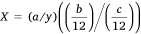
where, X = Annual stocking rate at a stockpost
y = size of daily grazing area (ca. 1963 ha)
a = total number of livestock for the months that a stockpost was occupied
b = number of months that a stockpost was occupied
c = total number of months for the data period
Data mapping
A total of 595 stockposts were used by pastoralists, and their monthly grazing areas were mapped in ArcGIS 9.3. Separate vector files were created for the data period as a whole, for each of the 8 years, and for the 12 months of the year thus providing 21 time periods in total. The vector files were converted into raster files using IDRSI 3.2 creating pixel sizes of 0.714 ha. The raster files of a particular time period were overlain, and the resultant image contained the union of all information of a particular time period. Images were clipped with the boundaries of the study area. Each of the 21 images of stocking density was overlain on the six main vegetation types.
Data analysis
Using a grazing radius of 2.5 km around a stockpost and the recommended stocking rate for the region of 1 SSU/10 ha, approximately 196 SSU could be kept at a stockpost throughout the year. Stocking density data were extracted from the maps and density categories of 0.2 SSU/10 ha were created. All the pixels with zero stocking densities were regarded as ungrazed areas. Pixels with stocking densities >1 SSU/10 ha were categorised as overstocked. The average stocking density per vegetation type was calculated as the sum of all the stocking densities of the pixels divided by the number of pixels in each vegetation type.
Results
Distribution of stocking density in the Leliefontein pastoral area
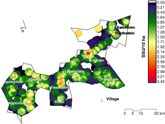
The average stocking density was spatially unevenly distributed (Fig. 2). Stocking density was above the recommended stocking rate more commonly around human settlements. Other areas were under stocked, and some were not grazed by livestock. Ungrazed areas were at some distance from human settlements and included inaccessible mountainous areas. The spatial distribution of stocking density was even around Paulshoek village. In villages such as Kamassies and Rooifontein in the north, grazing was concentrated mainly around the villages, and large areas of the rangeland were ungrazed.
|
Annual stocking density was spatially unevenly distributed between 1999 and 2006 (Fig. 3). The same areas were consistently overstocked or stocked at below the recommended rate, while large areas in the north were ungrazed. The distribution of stocking density also remained relatively uneven throughout the year. Grazing distribution was more clumped during the dry summer months (November–March) when animals depend solely on artificial water sources (Fig. 4). Stocking densities were higher during the winter months, since animals are sold during the summer months and because of animals born during winter. However, stocking density was more dispersed in winter than in summer, since animals obtain moisture from the vegetation and are less dependent on artificial water sources since they use ephemeral natural pools.

|

|
Distribution of stocking density amongst the different vegetation types
Water points and stockposts used were unevenly distributed within vegetation types (Table 1). Namaqualand Blomveld comprises about 20% of the study area, but 40% of stockposts and about 46% of water points used were in this vegetation type. About half of the study area is comprised of Namaqualand Klipkoppe Shrubland vegetation, but contained approximately 30% of stockposts and 17% of water points.
Kamiesberg Mountains Shrubland and Namaqualand Klipkoppe Shrubland vegetation were stocked on average below the recommended stocking rate. Kamiesberg Granite Fynbos and Namaqualand Granite Renosterveld vegetation had the highest stocking density of the six vegetation types (Fig. 5a). In 2004, following the 2002/2003 drought, all vegetation types, and the study area as a whole, were grazed at or below the recommended stocking rate. This was a consequence of high livestock mortality during the drought and the cold, wet period immediately following.

|
Kamiesberg Granite Fynbos and Namaqualand Granite Renosterveld vegetation had more than half of their area stocked above the recommended stocking rate for most of the data period (Fig. 5b). These two types, together with Namaqualand Heuweltjieveld, had the least area ungrazed. The ungrazed area was relatively constant over time for all vegetation types since ungrazed areas lacked water and were inaccessible to pastoralists via the road network.
Between April and October most livestock left areas of Kamiesberg Granite Fynbos and Namaqualand Granite Renosterveld vegetation (Fig. 6a), and moved mainly to Namaqualand Klipkoppe Shrubland vegetation, which comprises more than half the study area. This resulted in only a small rise in stocking densities in Namaqualand Klipkoppe Shrubland because the Fynbos and Renosterveld vegetation types are two of the smallest (i.e. 9% in total), and there were few animals on these two types relative to other types. However, these two vegetation types were heavily utilised by small stock from September to mid-April.

|
Discussion
Pastoralists generally established their stockposts at locations historically used by their forefathers. Thus, that this study reports on stockpost locations from 1999 to 2006 remains relevant since traditional strategies of herd movement by Nama pastoralists continued. Furthermore, this study assumed a fixed circular grazing radius of 2.5 km around a stockpost, and did not consider the complex topography in some parts of the rangeland that affects this radius. Although this is a limitation of the study, the effect of topography on stocking density was still captured since some herds moved along an elevational gradient.
Stocking densities within different vegetation types
The role of landscape features
Pastoralists moved their herds along an elevation gradient from Kamiesberg Granite Fynbos and Namaqualand Granite Renosterveld vegetation to the Succulent Karoo biome vegetation types in winter. Although the main reasons for moving were to avoid low temperatures and frost in the uplands, pastoralists also regarded the two Fynbos biome affinities as ‘sourveld’ and the Succulent Karoo vegetation types as ‘sweetveld’. In winter, ‘sourveld’ vegetation declines in nutritive value as plants mature (Meissner 2000). Aware of this change, pastoralists moved to ‘sweetveld’, which has higher winter grazing value (Meissner 2000). Good quality forage is important to maintain ewe physical condition for the winter lambing season. Movement of most pastoralists to ‘sweetveld’ resulted in lower stocking density recorded for the two Fynbos biome vegetation types in winter.
The specific grazing area to which pastoralists in Leliefontein moved in winter also depended on whether plants were in flower. Pastoralists preferred these areas, as ephemeral winter/spring-flowering plants comprise over 90% of the livestock diet (Samuels et al. 2016). Such areas often included fallow croplands and other disturbed areas. Pastoralists believed that flower consumption stimulates milk production in ewes. In other mobile pastoral systems, herds do not relocate unless one or several criteria are fulfilled. Elsewhere in Africa, for example, Fulani pastoralists first move to an area on a temporary basis and will only stay if forage quality is good and key forage species present (Ba 1982 cited in Niamir 1991). Similarly, in India, scouts are sent out to evaluate rangeland condition before a pastoral herd is moved to a particular location (Agrawal 1993).
Kamiesberg Granite Fynbos and Namaqualand Granite Renosterveld vegetation contain several ephemeral wetlands which herds were able to graze when they returned to the upland areas in summer. Wetlands provided good quality forage during summer as they contain several indigenous palatable plant species (Kotze et al. 2010). In other mobile pastoral systems, wetlands have been described as key resource areas important for herd survival during the dry season (Scoones 1991). In the Richtersveld National Park in South Africa, patches of Cynodon dactylon grass on the banks of the Orange River provide pastoralists with good quality summer forage (Hendricks et al. 2004). The Sahelian floodplains too provide pastoral livestock with important forage resources during the dry season (Scholte and Brouwer 2008).
Up to 30% of some vegetation types were ungrazed, indicating uneven grazing distribution with some areas overstocked. Overstocking has negative implications for perennial plant diversity in the Namaqualand region (Todd and Hoffman 1999; Riginos and Hoffman 2003), while Todd and Hoffman (1999, 2009) suggested overgrazing during the flowering season may lower seed production and palatable plant recruitment. Furthermore, in lowland habitats, heavy grazing transformed the vegetation from a perennial to an annual dominated landscape and led to fence line contrasts between the study area and adjacent private farms (Todd and Hoffman 1999).
The role of drought
High livestock mortalities during drought usually keep animal numbers below the long-term carrying capacity of the rangeland (Ellis and Swift 1988; Sullivan and Rohde 2002; Vetter 2005). High livestock mortality during drought, a characteristic of non-equilibrium systems (Vetter 2005), was evident in 2003–2004 in Leliefontein when no vegetation type was grazed above the recommended stocking rate. High livestock mortalities during drought and the subsequent cold snap resulted from poor nutrition and a lack of sufficient water that lead to poor physical condition and compromised immune systems. However, the livestock population recovered to pre-drought levels within 2 years due to good rains and large parts of the study area were grazed at levels above the recommended stocking rate. This was facilitated by pastoralists’ long-term strategy of selecting for livestock that produce multiple offspring. Pastoralists do not have financial means to buy livestock and restock after drought, and depend on the genetic characteristics of their herds to facilitate recovery post drought.
The greater variability in the total size of the livestock population in the Leliefontein pastoral area over time suggests that livestock are vulnerable to climatic perturbations. Greater vulnerability results from vegetation in some parts of Leliefontein having shifted from a perennial to an annual dominated plant community due to continuous high grazing intensity (Todd and Hoffman 1999; Anderson 2008). Thus, during periods of low rainfall, forage production would be below that required by the livestock, resulting in high livestock mortalities.
Conclusion
This study described temporal and spatial variation in stocking density among major vegetation types in the Leliefontein pastoral area. From 1999 to 2006, the same areas within a vegetation type were overstocked by small stock whereas other areas were ungrazed. Thus, in a dryland pastoral system, a livestock management strategy with fixed stocking rates as proposed by agricultural policies that does not consider vegetation heterogeneity is impractical. Forage availability varies at different scales in space and time across the landscape and pastoralists must match this natural variability through flexibility in stockposts movements. By using flexible stocking rate ranges for different vegetation types such as in Leliefontein, pastoralists could take advantage of increased primary production in wetter years, which they would be unable to do if using fixed and conservative stocking rates. This is in agreement with Campbell et al. (2006) who suggested that the ‘one size fits all’ stocking regime does not fit all farming systems. Carrying capacities depend on vegetation type, climate and on the specific farming objectives (Fritz and Duncan 1994).
There was no drought reserve due to the high number of herds in the study area nor a formalised grazing management system that would allow for areas to be routinely rested. Therefore, development programmes should focus on further lowering stocking densities during and after drought by providing pastoralists with additional livestock markets.
Data availability
Data used in this study is stored on a server of a public institution in South Africa and could be made available upon a reasonable request to the corresponding author.
Conflicts of interest
The authors declare that they do not have any conflicts of interests.
Declaration of funding
This research was funded by the Critical Ecosystems Partnerships Fund.
Supplementary material
Supplementary material is available online.
Acknowledgements
This paper forms part of the PhD thesis of Mogamat Igshaan Samuels (2013) entitled ‘Pastoral mobility in a variable and spatially constrained South African environment’. University of Cape Town. (http://www.pcu.uct.ac.za/sites/default/files/image_tool/images/192/samuels%202013.pdf).
References
Adler, PB, Raff, DA, and Lauenroth, WK (2001). The effect of grazing on the spatial heterogeneity of vegetation. Oecologia 128, 465–479.| The effect of grazing on the spatial heterogeneity of vegetation.Crossref | GoogleScholarGoogle Scholar |
Agrawal, A (1993). Mobility and cooperation among nomadic shepherds: the case of the Raikas. Human Ecology 21, 261–279.
| Mobility and cooperation among nomadic shepherds: the case of the Raikas.Crossref | GoogleScholarGoogle Scholar |
Allen, VG, Batello, C, Berretta, EJ, Hodgson, J, Kothmann, M, Li, X, McIvor, J, Milne, J, Morris, C, Peeters, A, and Sanderson, M (2011). An international terminology for grazing lands and grazing animals. Grass and Forage Science 66, 2–28.
| An international terminology for grazing lands and grazing animals.Crossref | GoogleScholarGoogle Scholar |
Anderson PML (2008) The impact of grazing along an environmental gradient in the Kamiesberg, South Africa. PhD Thesis, University of Cape Town, Cape Town, South Africa.
Anderson, GD, and Talbot, LM (1965). Soil factors affecting the distribution of the grassland types and their utilisation by wild animals on the Serengeti Plains, Tanganyika. Journal of Ecology 53, 33–56.
| Soil factors affecting the distribution of the grassland types and their utilisation by wild animals on the Serengeti Plains, Tanganyika.Crossref | GoogleScholarGoogle Scholar |
Bailey, DW, Keil, MR, and Rittenhouse, LR (2004). Research observation: Daily movement patterns of hill climbing and bottom dwelling cows. Journal of Range Management 57, 20–28.
| Research observation: Daily movement patterns of hill climbing and bottom dwelling cows.Crossref | GoogleScholarGoogle Scholar |
Bassett, TJ (1986). Fulani herd movements. Geographical Review 76, 233–248.
| Fulani herd movements.Crossref | GoogleScholarGoogle Scholar |
Behnke RH, Scoones I (1993) Rethinking range ecology: implications for rangeland management in Africa. In ‘Range ecology at disequilibrium: new models of natural variability and pastoral adaptation in African savannas’. (Eds RH Behnke, I Scoones, C Kerven) pp. 1–30. (Overseas Development Institute: London, UK)
Beukes, PC, and Cowling, RM (2000). Impacts of non-selective grazing on cover, composition and productivity of Nama-karoo grassy shrubland. African Journal of Range and Forage Science 17, 27–35.
Campbell, BM, Gordon, IJ, Luckert, MK, Petheram, L, and Vetter, S (2006). In search of optimal stocking regimes in semi-arid grazing lands: one size does not fit all. Ecological Economics 60, 75–85.
| In search of optimal stocking regimes in semi-arid grazing lands: one size does not fit all.Crossref | GoogleScholarGoogle Scholar |
Coppock, DL, Ellis, JE, and Swift, DM (1986). Livestock feeding ecology and resource utilization in a nomadic pastoral ecosystem. Journal of Applied Ecology 23, 573–583.
| Livestock feeding ecology and resource utilization in a nomadic pastoral ecosystem.Crossref | GoogleScholarGoogle Scholar |
Davis, CL, MT Hoffman, M, and Roberts, W (2016). Recent trends in the climate of Namaqualand, a megadiverse arid region of South Africa. South African Journal of Science 112, 1–9.
| Recent trends in the climate of Namaqualand, a megadiverse arid region of South Africa.Crossref | GoogleScholarGoogle Scholar |
DEA (Department of Environmental Affairs) (2013) ‘Long-Term Adaptation Scenarios Flagship Research Programme (LTAS) for South Africa.’ (Summary for Policy-Makers: Pretoria, South Africa)
Ellis, JE, and Swift, DM (1988). Stability of African pastoral ecosystems: alternate paradigms and implications for development. Journal of Range Management 41, 450–459.
| Stability of African pastoral ecosystems: alternate paradigms and implications for development.Crossref | GoogleScholarGoogle Scholar |
Esler KJE, Milton SJ, Dean WRJ (Eds) (2006) ‘Karoo veld: ecology and management.’ (Briza Press: Pretoria, South Africa)
Fauchereau, N, Trzaska, S, Rouault, M, and Richard, Y (2003). Rainfall variability and changes in southern Africa during the 20th century in the global warming context. Natural Hazards 29, 139–154.
| Rainfall variability and changes in southern Africa during the 20th century in the global warming context.Crossref | GoogleScholarGoogle Scholar |
Fritz, H, and Duncan, P (1994). On the carrying capacity for large ungulates of African Savanna Ecosystems. Biological Sciences 256, 77–82.
| 8008761PubMed |
Helme N, Desmet P (2006) ‘A description of the endemic flora and vegetation of the Kamiesberg uplands, Namaqualand, South Africa.’ (CEPF/SKEP: Cape Town, South Africa)
Hempson G (2010) Herbivore dynamics in an arid environment. PhD Thesis, University of Edinburgh, Edinburgh, Scotland.
Hendricks, HH, Midgley, JJ, Bond, WJ, and Novellie, PA (2004). Why communal pastoralists do what they do in the Richtersveld National Park. African Journal of Range and Forage Science 21, 29–36.
| Why communal pastoralists do what they do in the Richtersveld National Park.Crossref | GoogleScholarGoogle Scholar |
Hendricks, HH, Clark, B, Bond, WJ, Midgley, JJ, and Novellie, PA (2005). Movement response patterns of livestock to rainfall variability in the Richtersveld National Park. African Journal of Range and Forage Science 22, 117–125.
| Movement response patterns of livestock to rainfall variability in the Richtersveld National Park.Crossref | GoogleScholarGoogle Scholar |
Illius, AW, and O’Connor, TG (1999). On the relevance of nonequilibrium concepts to arid and semiarid grazing systems. Ecological Applications 9, 798–813.
| On the relevance of nonequilibrium concepts to arid and semiarid grazing systems.Crossref | GoogleScholarGoogle Scholar |
Kotze D, Malan H, Ellery W, Samuels I, Saul L (2010). Assessment of the environmental condition, ecosystem service provision and sustainability of use of two wetlands in the Kamiesberg Uplands. Report No. TT439-09 Water Research Commission, Pretoria, 189 pp.
Low, WM, Dudzinski, ML, and Muller, WJ (1981). The influence of forage and climatic conditions on range community preference of shorthorn cattle in central Australia. Journal of Applied Ecology 18, 11–26.
| The influence of forage and climatic conditions on range community preference of shorthorn cattle in central Australia.Crossref | GoogleScholarGoogle Scholar |
McCabe JT (1994) Mobility and land use among African pastoralists: Old conceptual problems and new interpretations. In ‘African pastoralist systems. An integrated approach’. (Eds E Fratkin, KA Galvin, EA Roth) pp. 69–90. (Lynne Rienner: London, UK)
Meissner HH (2000). Nutrient supplementation of the grazing animal. In ‘2000. Pasture management in South Africa’. (Ed. NM Tainton) p. 355. (University of Natal Press: Pietermaritzburg, South Africa)
Mucina L, Rutherford MC (2006) ‘The vegetation of South Africa, Lesotho and Swaziland’, (South African National Biodiversity Institute: Pretoria)
Niamir M (1991) ‘Traditional African range management techniques: implications for range development.’ (Paper 31d, Pastoral Development Network, Overseas Development Institute)
Niamir-Fuller M (1999) Conflict management and mobility among pastoralists in Karamoja, Uganda. In ‘Managing mobility in African rangelands: the legitimization of transhumance’. (Ed M Niamir-Fuller) pp. 149–183. (Intermediate Technology Publications: London)
Niamir-Fuller M, Turner MD (1999) A review of recent literature on pastoralism and transhumance in Africa. In ‘Managing mobility in African rangelands: the legitimization of transhumance’. (Ed. M Niamir-Fuller) pp. 18–46. (Intermediate Technology Publications: London)
O’Brien, EM (1993). Climatic gradients in woody plant species richness: towards an explanation based on an analysis of southern Africa’s woody flora. Journal of Biogeography 20, 181–198.
Riginos, C, and Hoffman, MT (2003). Changes in population biology of two succulent shrubs along a grazing gradient. Journal of Applied Ecology 40, 615–625.
| Changes in population biology of two succulent shrubs along a grazing gradient.Crossref | GoogleScholarGoogle Scholar |
Samuels MI (2013) Pastoral mobility in a variable and spatially constrained South Africa environment. PhD Thesis, University of Cape Town, Cape Town, South Africa.
Samuels, MI, Allsopp, N, and Knight, RS (2007). Patterns of resource use by livestock during and after drought in a communal rangeland in Namaqualand, South Africa. Journal of Arid Environments 70, 728–739.
| Patterns of resource use by livestock during and after drought in a communal rangeland in Namaqualand, South Africa.Crossref | GoogleScholarGoogle Scholar |
Samuels, MI, Allsopp, N, and Hoffman, MT (2008). Mobility patterns of livestock keepers in semi-arid communal rangelands of Namaqualand, South Africa. Nomadic Peoples 12, 123–148.
| Mobility patterns of livestock keepers in semi-arid communal rangelands of Namaqualand, South Africa.Crossref | GoogleScholarGoogle Scholar |
Samuels, MI, Cupido, C, Swarts, MB, Palmer, AR, and Paulse, JW (2016). Feeding ecology of four livestock species under different management in a semi-arid pastoral system in South Africa. African Journal of Range and Forage Science 33, 1–9.
| Feeding ecology of four livestock species under different management in a semi-arid pastoral system in South Africa.Crossref | GoogleScholarGoogle Scholar |
Samuels, MI, Swarts, MBV, Schroeder, A, Ntombela, KP, and Cupido, CF (2018). Through the lens of a herder: insights into landscape ethno-ecological knowledge on rangelands in Namaqualand. Anthropology Southern Africa 41, 136–152.
| Through the lens of a herder: insights into landscape ethno-ecological knowledge on rangelands in Namaqualand.Crossref | GoogleScholarGoogle Scholar |
Samuels, MI, Allsopp, N, and Hoffman, MT (2019). Traditional mobile pastoralism in a contemporary semi-arid rangeland in Namaqualand, South Africa. Rangeland Ecology and Management 72, 195–203.
| Traditional mobile pastoralism in a contemporary semi-arid rangeland in Namaqualand, South Africa.Crossref | GoogleScholarGoogle Scholar |
Schareika, N (2001). Environmental knowledge and pastoral migration among the Wodaabe of South-Eastern Niger. Nomadic Peoples 5, 61–88.
| Environmental knowledge and pastoral migration among the Wodaabe of South-Eastern Niger.Crossref | GoogleScholarGoogle Scholar |
Scholes, RJ, Dowty, PR, Caylor, K, Parsons, DAB, Frost, PGH, and Shugart, HH (2009). Trends in savanna structure and composition along an aridity gradient in the Kalahari. Journal of Vegetation Science 13, 419–428.
| Trends in savanna structure and composition along an aridity gradient in the Kalahari.Crossref | GoogleScholarGoogle Scholar |
Scholte P, Brouwer J (2008). Relevance of key resource areas for large-scale movements of livestock. In ‘Resource ecology: spatial and temporal dynamics of foraging’. (Eds HHT Prins, F van Langevelde) pp. 211–232. (Springer: The Netherlands)
Scoones, IE (1991). Wetlands in drylands: key resources for agricultural and pastoral production in Africa. Ambio 20, 366–371.
Scoones I (Ed) (1995) ‘Living with uncertainty: new directions in pastoral development in Africa.’ (Intermediate Technology Publications: London)
Sullivan, S, and Rohde, R (2002). On non-equilibrium in arid and semi-arid grazing systems. Journal of Biogeography 29, 1595–1618.
| On non-equilibrium in arid and semi-arid grazing systems.Crossref | GoogleScholarGoogle Scholar |
Todd, SW (2006). Gradients in vegetation cover, structure and species richness of Nama-Karoo shrublands in relation to distance from livestock watering points. Journal of Applied Ecology 43, 293–304.
| Gradients in vegetation cover, structure and species richness of Nama-Karoo shrublands in relation to distance from livestock watering points.Crossref | GoogleScholarGoogle Scholar |
Todd, SW, and Hoffman, MT (1999). A fence-line contrast reveals effect of heavy grazing on plant diversity and community composition in Namaqualand, South Africa. Plant Ecology 142, 169–17.
| A fence-line contrast reveals effect of heavy grazing on plant diversity and community composition in Namaqualand, South Africa.Crossref | GoogleScholarGoogle Scholar |
Todd, SW, and Hoffman, MT (2009). A fence line in time demonstrates grazing-induced vegetation shifts and dynamics in the semiarid succulent Karoo. Ecological Applications 19, 1897–1908.
| A fence line in time demonstrates grazing-induced vegetation shifts and dynamics in the semiarid succulent Karoo.Crossref | GoogleScholarGoogle Scholar | 19831078PubMed |
Valentine, JF (2000). ‘Grazing management’, 2nd edn. (Academic Press: San Diego, CA, USA)
Vetter, S (2005). Rangelands at equilibrium and non-equilibrium: recent developments in the debate around rangeland ecology and management. Journal of Arid Environments 62, 321–341.
| Rangelands at equilibrium and non-equilibrium: recent developments in the debate around rangeland ecology and management.Crossref | GoogleScholarGoogle Scholar |