

Recent trends in soil fertility across the farms of East Gippsland
D. M. Crawford A C , B. Mitchard A and W. R. Burton B
A Department of Jobs, Precincts and Regions, 1301 Hazeldean Road, Ellinbank, Victoria.
B East Gippsland Shire Council, 273 Main Street, Bairnsdale, Victoria.
C Corresponding author. Email: doug.crawford@agriculture.vic.gov.au
Soil Research 58(6) 561-575 https://doi.org/10.1071/SR19246
Submitted: 10 September 2019 Accepted: 27 May 2020 Published: 12 August 2020
Journal Compilation © CSIRO 2020 Open Access CC BY
Abstract
Current data are needed to manage our soil resources but there are few recent purpose-built surveys of soil fertility, a critical asset for natural resources management. Instead, data collected for other purposes are re-used as has been the case in our area of interest here: managing the threat of soil erosion on farm land in East Gippsland. The dynamic nature of soil fertility challenges this approach, so we conducted a new survey using 234 paddocks selected at random. These new data were compared to re-purposed legacy data. Plant tissue samples from a selected subset were used to assess micronutrients. Separately, 27 paddocks that had been sampled during 1975–89 were re-tested to examine temporal changes. We concluded that many paddocks are now strongly or very strongly acidic and deficient in molybdenum (Mo) and boron (B). More specifically, those under dairying, cropping and horticulture are likely to have adequate phosphorus (P) while those grazed for meat and wool are likely to be deficient in P. We concluded that grazing enterprises need to either re-adopt soil testing and fertiliser treatment or adopt management practices suitable for acid soils deficient in P, Mo and B, if their paddocks are to support sustainable productive agriculture. Data from the re-tested paddocks suggest that, in general, many were once less acidic, highlighting the difficulties in using legacy data. Also, contrasts in soil pH and available P between paddocks under different management regimes, highlighted the difficulties in using re-purposed data. We concluded that a statistically designed survey is a preferable basis for natural resource management.
Additional keywords: dryland cropping, nutrient status, pasture soils, soil fertility, soil pH.
Introduction
Australia’s National Soil Research, Development and Extension Strategy (Department of Agriculture, Fisheries and Forestry 2014) aims to ‘improve the quality, availability and access to soil data and information to meet user needs’, so as to achieve ‘improved understanding of the condition of the resource base’. However, there are few recent reports of purpose-built research that provide spatial information on soil fertility, let alone soil health and condition at either regional or state scales. Recent efforts to get baseline data on soil carbon stocks (Robertson et al. 2016) did not use a statistical design. Indeed, spatial information on soil fertility has often been created by opportunistic use of soil data from the extension programs or soil testing services offered to farmers (Helyar et al. 1990; MacLaren et al. 1996; Natural Heritage Trust (Australia) National Land and Water Resources Audit 2001; Scott et al. 2007; Apted et al. 2014; Marchant et al. 2015). Inferences drawn from such re-purposed data can be challenged. Here, we report on a purpose-built survey of soil fertility in the farming land of East Gippsland, to both show current trends and to explore and learn from the contrasts with re-purposed legacy data.
East Gippsland is a suitable study area since it has different kinds of agricultural industries, e.g. field cropping, grazing for dairying, meat and wool, on a range of contrasting soils and landscapes (Department of Primary Industries 2010, 2011a, 2011b, 2011c). It has been estimated that the risk of sheet and rill erosion, tunnel and gully erosion is high or very high in 50% of freehold land, mainly on the Eastern Uplands, and is 36% for wind erosion (Sargant 2009). The regional catchment management strategy (East Gippsland Catchment Management Authority 2013) seeks to manage these risks through spatially targeted improvement in the productive values and stability of agricultural land. Specifically, it aims to achieve this objective by getting farmers to improve grazing practices and species selection, and to increase the use of soil testing to guide remedial action or changes to management. The survey reported here was conducted to enable the targeting of resources and to provide a means of engaging with farmers to encourage them to test soil. But why did we need new data?
The most recent published information available for East Gippsland dates from 1999. It is based on soil test data collated for the National Land and Water Resources Audit (Natural Heritage Trust (Australia) National Land and Water Resources Audit 2001) (hereafter the Audit) from commercial and government laboratories. Farmers use such data to routinely manage soil fertility and condition but its relevance to current conditions can be questioned. Much about farming has changed since 1999. New technologies, variations in prices of inputs and outputs, and the recent Millennium Drought (1997–2010) have all provided incentives to change farming systems. This includes the use of inputs such as fertilisers and lime, as well as the mix of crops and pastures and the management practices specific to each. Furthermore, the geo-referencing of the data in the Audit was too coarse to ascertain trends in fertility or differences between soil map units at the regional scale in East Gippsland. Importantly, the Audit does not inform on the adequacy of micronutrients, which are critical to legume-based pastures in East Gippsland. Soil tests are not useful for predicting the response to the application of micronutrients (Peverill et al. 1999). Further, there is a dearth of spatial data on responses to the application of micronutrients since the review of Hosking et al. (1986). Therefore, new and better information was needed.
There are now textbooks on the use of geostatistics to design sampling schemes for mapping land and soil, e.g. de Gruijter et al. (2006). Where a simple inventory of soil properties is needed, a survey design based on random selection of sampling sites will suffice. More complicated designs such as stratified random sampling can utilise features of interest, e.g. soil type and enterprise, to more efficiently summarise differences in the target soil property in different parts of the landscape. Where such features are known to be co-related to the target soil property and this can be described by a model, these can be used to improve survey efficiency. Where a spatio-temporal survey is desired to both map and monitor soil, more complex modelling can be used. However, few regional- or national-scale inventories of soil fertility in Australia are based on a statistical approach (Hodge and Lewis 1989). Researchers and their funders may have been dissuaded from this by the extra effort and resources necessary to conduct a such statistically designed survey. Mostly, they have either collated data from routine soil testing laboratories (Helyar et al. 1990; MacLaren et al. 1996; Natural Heritage Trust (Australia) National Land and Water Resources Audit 2001; Marchant et al. 2015), or engaged with farmers to participate in a survey, e.g. Scott et al. (2007) and Apted et al. (2014), with the farmers volunteering composite samples from paddocks for testing and the researchers funding the laboratory analysis. Site selection is not random in either approach, nor is participation in an extension program or the use of soil testing.
Collating data from routine soil-testing laboratories is attractive as the logistical, sampling and analytical costs are all sunken. Importantly, such datasets have been large, e.g. data from 103 589 samples collected during 1990–99 were collated for Victoria for the Audit. Soil testing to manage soil fertility is not mandatory in Australia. Farmers’ soil samples are taken to either optimise fertiliser inputs, monitor the impacts of management practices on soil fertility or identify the cause of undesirable plant performance with the objective of ameliorating any identified soil constraints or deficiencies. Inferences from these datasets may therefore be prone to bias as it can be assumed that the paddocks are not randomly selected but are selected for a purpose. Information on the purpose for sampling is not always provided when samples are submitted, and the purpose may not be the same in different regions or different farming systems. This may also change over time (Lemercier et al. 2008). This potential bias is inherent in many legacy datasets and the difficulty in accounting for this bias, without information on the reason for paddock selection, has been recognised (Wheeler et al. 2004; Arrouays et al. 2012; Marchant et al. 2015).
Using the second approach, Scott et al. (2007) gained access to more than 4700 paddocks through 27 farmer groups participating in extension programs. Unfortunately, the motivation for farmers to engage in such groups is not well documented (Lobry de Bruyn 2019), let alone the motivation or apathy to not engage, or to use soil testing or not. It is also evident that a minority of Australian farmers use soil testing or participate in soil extension programs (Australian Bureau of Statistics 2013). Importantly, Gazey et al. (2014) reported that the soil sampling practices and intentions of farmers who were part of a long-term extension and research program on soil acidity, were different to those who did not participate. Therefore, inferences drawn from these datasets can be challenged on the basis of self-selection on the part of the farmer, in addition to the biased selection of a paddock.
Few have attempted to assess the bias from purposive sampling inherent in farmer-derived data or to provide solutions to this problem. Rawlins et al. (2017) suggested using contemporaneous data from surveys to assess the importance of unidentified sources of bias. They tested this suggestion by comparing a national-scale survey of soil fertility compiled from farmer-derived data, i.e. a survey with purposely designed sampling, to three national surveys with statistically designed sampling. While the means of soil pH data from the different surveys were consistent, the means for available phosphorus (P) were not. They in part attributed this result to differences in the method of testing available P but would not discount other sources of bias such as purposive selection of paddocks. For the research reported here, we used an alternative approach, where a small set of paddocks represented in the Audit and in Marchant et al. (2015) were re-tested and compared.
In summary, we report a survey of current trends in soil fertility across farmland in East Gippsland. This is supported by plant tissue testing of selected paddocks to detect micronutrient deficiencies. Soil data from the survey were compared to routine soil testing collated from two sets of legacy data. In addition, a temporal study using a small set of paddocks represented in the legacy data were re-tested to relate the survey and legacy data. The experimental units of the new survey, a paddock, were selected at random whereas those represented in the legacy data and the temporal study can be assumed to be purposively selected.
Materials and methods
Soil fertility
The study area is the farming land of the East Gippsland Catchment Management Authority region in far eastern Victoria, Australia (Fig. 1). Of the 2.2 million hectares in this region, 83% is public land under forestry or native vegetation with the remaining being freehold. The freehold land is mostly used for agriculture. Little of the steep topography of the Eastern Uplands (Fig. 1) is freehold or used for agriculture. Farming occurs mostly on the less steep slopes and flats at Dargo, Swifts Creek and Bonang, and the lower slopes and flood plains along the major rivers (Mitchell, Buchan, Tambo, Snowy, Cann and Genoa) and their tributaries. In contrast, most of the land of the Eastern Plains is freehold and is used for agriculture. From a survey of farmers conducted in 2011–12 (Australian Bureau of Statistics 2013), it can be inferred that 312 582 ha was used for agriculture by 850 farm businesses, with 292 453 ha used for grazing and 14 455 ha for cropping or horticulture.

|
The experimental unit for this survey is a paddock. There were 291 paddocks selected at random, and these were on 266 properties. The method of Theobald et al. (2007), as applied using ArcMap 10.1 (™ ESRI), was used to select each paddock. This method was initially applied as a simple random selection of points; if a point fell in a paddock, it was selected. Selected paddocks were dropped from the survey for several reasons including refusal by land managers to participate or because the land manager or owner could not be contacted. The paddocks were sampled in 2014 and 2015. During 2014, it became evident that some types of land and soil were only represented by a small number of sampled paddocks. A stratum was introduced to make the design a stratified random sampling scheme. This alteration to the design was needed to ensure useful statistical summaries could be provided for all types of land with soils of interest to this survey. Strata were developed using soil maps for East Gippsland (Department of Primary Industries 2010, 2011a, 2011b, 2011c). Map units dominated by similar soil types were grouped into soil classes (Table 1). It was hypothesised that differences in important soil properties (e.g. reaction, available nutrient reserves and texture) would be greatest between these classes. Additional paddocks were randomly selected with the aim of obtaining at least 20 paddocks for each soil class.

|
The paddocks were sampled using the same approach as is recommended to farmers for routine soil testing (Brown 1999). They were sampled during autumn and early winter of each year. The paddocks were sampled before fertiliser or soil ameliorants were applied, or after more than six weeks of the growing season succeeding application. At each paddock, 30 intact cores (0–10 cm depth) were taken in a rough grid or at random to form a composite sample, representing the main part of the paddock and excluding atypical areas such as stock camps. Paddocks varied in size and shape such that the sampling pattern and core spacing varied accordingly. Where differences in soil type or landform were assessed as being likely to give different soil test results and were of sufficiently large area to constitute a separate management unit, the paddock was split with a separate sample being taken from each part. Consequently, there were 198 samples where each represented a paddock, and 36 samples where each represented two separate management units in each of 18 paddocks; a total of 234 composite samples representing 234 management units were available for study. For brevity, a management unit will be called a paddock.
The samples were prepared and analysed as would be done for farmers using routine soil testing services. That is, they were air-dried at 40°C in a forced air-draught oven for four days. The air-dried samples were then sieved and ground to pass a 2-mm sieve. The routine soil tests selected for the survey were (with the method code from Rayment and Lyons (2011)): available P as Olsen P (9C2b), P buffering index (9I2B), extractable cations (15D3) from which available potassium (K) and exchangeable sodium percentage (ESP) were calculated, pH and electrical conductivity (EC) (4A1, 4B4 and 3A1) and total organic carbon (6B2b). Available sulfur (S) was extracted in calcium di-hydrogen phosphate followed by treatment with charcoal to remove organic S from the supernatant (Brown et al. 1980). Soil organic matter was calculated from total organic carbon using a correction factor of 1.85. In addition, finely ground subsamples (>95% of <100 μm) were prepared and scanned using a Perkin-Elmer Spectrum One Fourier Transform MIR spectrometer at 8 cm−1 resolution, from 450 to 7800 cm−1 for 1 min. Predictions of the contents of clay, silt, fine sand, coarse sand and total sand were made from calibration models based on 7381 samples which had particle size analysis after destruction or removal of aggregating components, e.g. Mikhail and Briner (1978), using either a pipette, hydrometer or plummet balance. The calibration models are based on partial least-squares regression analysis of spectra and laboratory data. The calibration dataset included samples from soil and land surveys of East Gippsland. These predictions were used to estimate field texture using the texture triangle of Marshall (1947) based on the proportions of sand, silt and clay in the mineral fine earth fraction.
Management information was recorded from the farmer or landowner using a brief questionnaire. Management information included enterprise, fertiliser history and soil testing history. No records were available from four paddocks and only sufficient detail was available from the remainder to enable a broad qualitative classification of different aspects of the management applied to each paddock. No attempt was made to quantify nutrient balances or grazing densities. Information was particularly lacking where ownership had changed, where only limited records were kept by the farmer or where the landowner did not have the lessee’s records.
The sampled area was geo-referenced either by digitising from maps drawn in the field on aerial photographs, or from fixes obtained using low-resolution hand-held geo-positioning system devices, e.g. GARMIN 76S. Landform at each paddock was classified according to the National Committee on Soil and Terrain (2009). The medians of slope and elevation were estimated from a rasterised representation of elevation at a spatial resolution of 10 m (Department of Environment Land Water and Planning 2008). Similarly, the geomorphic unit at tier 1, 2 or 3 of the Victorian Geomorphic Framework (Rees 2000) was assigned to summarise the geomorphology of each site.
Statistical analysis was conducted using GENSTAT version 18.1 (VSN International Ltd). ANOVA was used to detect significant differences between different variates (continuous data) and factors (categorical data) such as management, environment, land and soil, that may affect soil fertility. Classes of factors were confined to those that efficiently summarised natural and anthropogenic relationships. Factors used to describe management were enterprise, frequency of fertilising and frequency of soil testing. Variates included median values of slope, elevation, rainfall, as well as easting and northing (MGA55) of the centroid of the paddock. Data from tests of available P, K and S, and P buffering index were skewed. This data was log10 transformed when applying ANOVA with the ‘treatment’ means being transformed back for reporting. Paddocks grazed for dairying were separated from those grazed by other livestock, under the presumption that their farming systems would be different in intensity of inputs such as fertiliser and stockfeed. Where statistical analysis was used to study the effects of agricultural management practices, paddocks that were not stocked or not used for agriculture were excluded.
The survey data can be compared to legacy datasets from samples submitted for routine soil testing to laboratories from East Gippsland over the period of 1973–99. These laboratories received samples in which the recommended sampling method was the same as used here. The Audit collated data from samples submitted to commercial and government laboratories in Victoria during 1990–99. These samples were from the 0–10 or 0–15 cm depth. During 1973–89, the Government of Victoria provided a routine soil testing service to farmers through the Department of Agriculture and its successors. Extension officers submitted composite soil samples (0–10 cm depth, 20–30 cores) they had taken on behalf of the farmer, or if taken by the farmer, taken under the supervision of the extension officer. During 1989–94, this service operated through a commercial entity and these data are in the Audit. Only data determined using the same analytical methods were compared, i.e. pH(water) or pH(CaCl2), Olsen P and available K calculated from exchangeable K. Data in both legacy sets are geo-referenced to the nearest town. It was not possible to classify data into different enterprises in the legacy datasets.
Plant nutrition
Plant tissue testing was used to provide information on micronutrient nutrition of pastures; information that cannot be reliably obtained from soil testing (Peverill et al. 1999). Because legumes have a higher demand for micronutrients such as molybdenum (Mo), legumes were tested as indicator plants in preference to grasses where possible.
In 2014, 129 paddocks were available for sampling. Plant sampling could not be undertaken in 2015. Selection criteria were applied to provide the best opportunity to detect deficiencies in micronutrients. In paddocks with improved pastures, the following soil test criteria were applied: the Olsen P test result had to be greater than 14 mg kg−1, pH (1 : 5 soil : water) had to be more alkaline than 5.3 and available K had to be greater than 80 mg kg−1 soil (calculated from exchangeable K). For those with native pastures, the criterion for Olsen P was re-set to a range of 7–11 mg kg−1, with the other criteria left unchanged. There were 67 paddocks chosen for plant sampling. Samples were collected from 64 pastures and three which had been sown to wheat. Plant samples came from the same area of the paddock as the soil sample.
Plant sampling was in accord with recommended plant part and growth stage set out by Reuter and Robinson (1997) for the target species in each paddock. Growth stage at sampling and plant parts sampled were before flowering, most recently matured blade and petiole respectively, as recommended for subterranean clover (Trifolium subterraneum L.), white clover (Trifolium repens L.) and medic (Medicago spp.). Where too few pasture legumes were present, the most dominant grass species was sampled as an alternative. These were from kikuyu (n = 1, whole top), cocksfoot (n = 1, whole top), couch grass (n = 1, most recently matured blade) or ryegrass (n = 1, tiller). Grasses were sampled in the vegetative stage. In one paddock, the only option available was to sample a mix of native grasses (n = 1, whole top). Where the paddock was under wheat (n = 3), the most recently matured leaf was taken at growth stage GS25–27 (Zadoks et al. 1974). One-hundred plant parts (one per plant) or 30 whole tops were taken and bulked for testing. Where plants were stunted, the number of plants sampled was increased to 300 where plant parts were sampled. The samples were tested for the total content of nitrogen (N), S, calcium (Ca), P, copper (Cu), manganese (Mn), K, zinc (Zn), boron (B), magnesium (Mg), Mo and iron (Fe). Plant tissue analysis results were interpreted and classified using Reuter and Robinson (1997); only descriptive statistics are presented.
Temporal changes in fertility
A small study was undertaken to support the comparison of data from the new survey to legacy data. Paddocks that had been previously tested in one of the years during 1975–89 by the Department of Agriculture were re-sampled. These paddocks were not randomly selected at the second sampling.
To do such a study, it is necessary to verify that the same paddock is being sampled. There were 43 paddocks in the survey area initially identified for re-sampling. In the paddocks studied here, either an extension officer or the farmer under the supervision of an extension officer, took the original sample. Historical documents containing cursory paddock details and consultation with previous and current farmers, as well as a now-retired local extension officer, were then used to verify that the same paddock was re-sampled in each instance. Of the 43 paddocks, only 27 were located with sufficient confidence to be used in this study.
The paddocks were re-tested using the same methods of soil sampling and laboratory analysis as when previously tested. These methods are the same as those used in the survey described above. The laboratory analysis was conducted by same government laboratory. GENSTAT version 18.1 was used for statistical analysis of the re-sampled paddocks.
Results
The survey
A summary of the properties of the surveyed paddocks is provided in Table 2. The paddocks are at a range of elevations of 0–1007 m AHD and lie within 575–1200 mm isohyets. The survey was dominated by paddocks under grazing with other agricultural enterprises in the minority (Table 3). Those under crops were mainly on the Eastern Plains and those under horticulture were on the flood plain soils of the Mitchell River at Bairnsdale, an area long favoured for vegetable production (Fig. 1). In general, the surveyed paddocks on soils developed on sandstones, limestone, granite or basalt were in the Eastern Uplands, while those on dune soils, aeolian soil on clay or alluvial soils were on the Eastern Plains. Paddocks on flood plains were on both the Eastern Plains and the Eastern Uplands. Consequently, the characteristics of the paddocks, as described by data representing various aspects of the environment and farming systems, are confounded as is typical of data collected in these kinds of studies, e.g. Robertson et al. (2016). Therefore, analysis was confined to examining relationships based on expected cause-and-effect rather than casual co-relation, so as to efficiently summarise and communicate differences in soil fertility.

|

|
Among the surveyed paddocks, management practices were inconsistent across enterprises. For example, in paddocks where records were available on soil testing (n = 115), soil testing at least every 5 years was undertaken in six of the 10 paddocks under dairying, and in all of the seven paddocks used for cropping. In contrast, only 28 of the 69 used for grazing for meat and wool were tested every 2–5 years. In fact, 16 of these 69 were tested at frequencies greater than 10 years. Similarly, frequencies of fertilising paddocks for cropping, dairying and grazing differed. For example, where fertiliser records were available for pasture paddocks (n = 186), all 19 pastures under dairying were fertilised at least every 5 years with eight being fertilised more than once a year, whereas only 58 of the 151 pastures grazed by other livestock were fertilised at least every 5 years.
Soil matrix
The majority of the soil samples were coarse textured, mainly loamy sands, silty loams or loams, with only two being silty clays and 42 being clay loams or silty clay loams. The heavier textured examples came from paddocks on limestone, marine sediments or flood plains, these soils also tended to have higher organic matter content.
Aeolian soil on clay and dune soils, contained more coarse sand on average, than soils from other soil classes especially those formed on basalt or limestone (Table 4). The former are on landscapes in which beach ridges and stranded beach ridges and other coastal formations have been re-worked by wind (Jenkin 1968). Wind and wave action winnows out the finer particles, which are dispersed further away, leaving behind the coarser particles. The remaining surface soil samples originated from colluvial and alluvial environments and were not as coarse, on average, as those from landscapes affected by wind and wave erosion. In contrast, soils formed on limestone or basalt contained significantly more clay and silt.

|
Across the dataset, total organic carbon was significantly (P < 0.001) correlated with predicted clay content (r = 0.32). It was noteworthy that P buffering index was significantly (P < 0.001) correlated with clay content (r = 0.47) and total organic carbon content (r = 0.70).
Soil reaction
Soil pH(water) was <6.0 in 202 paddocks with 95 being moderately acidic (pH 5.5–6.0), 99 strongly acidic (pH 5.0–5.5) and eight very strongly acidic (pH 4.5–5.0). For soil pH(CaCl2), 202 paddocks had soil pH < 5.2, below which aluminium becomes soluble and can affect the growth of low-pH sensitive pastures and crops such as barley, lucerne and canola. This result shows that the growth of low-pH sensitive plants may be limited in the majority of paddocks in this region, and that in many the acidity was sufficient to limit plants more tolerant of low soil pH.
The more alkaline samples came from paddocks on limestone, basalt or from the more intensively managed flood plains, while the more acidic samples came from paddocks on granites, sandstones or dunes (Table 4). In fact, paddocks under horticulture (n = 4) were significantly less acidic than those under other enterprises (Table 5).

|
There was no significant difference (P > 0.05) in pH(CaCl2) between those which had been limed (n = 33) and those reported to have not been limed (n = 197). However, where details on liming were provided (n = 18), the lime application appeared to be sufficient in all but one case.
The mean pH of the survey data (µ = 4.84, σ = 0.461), as measured in 0.01 M CaCl2 suspension, was not significantly different (P > 0.05) to the mean of surface soil samples submitted to the Department of Agriculture for this region, over the period from when this method was adopted, i.e. 1985–94 (n = 1052, µ = 4.88, σ = 0.528). Nor was it significantly different (P > 0.05) to the mean of surface soil samples from the Audit (n = 1682, µ = 4.87, σ = 0.591).
Salinity
Only 11 paddocks were saline, i.e. EC > 0.25 dS m−1. All but two were from soils developed on marine sediments or flood plains and these were sodic (ESP > 6%). The remaining two were from limestone soils and were not sodic. Given salinity is a minor issue in this region, it is not considered further.
Available P
The Olsen P test results showed that 107 of the 234 surveyed paddocks were deficient in P for native pastures, i.e. <10 mg kg−1 Olsen P; and 162 were deficient in P for improved pastures, i.e. <15 mg kg−1 Olsen P. Twenty-four paddocks had Olsen P results above which there would be no response to applied P, i.e. >27 mg kg−1 Olsen P. The paddocks sampled around Swifts Creek in the Tambo Valley, and around and north of Buchan in the Buchan Valley were noteworthy for the number of low Olsen P results (Fig. 2). In contrast, some paddocks were notable for their high Olsen P results, e.g. 86 mg kg−1. Such high results typically came from paddocks under dairy or horticulture. The Olsen P data from some paddocks (n = 13) were so low, i.e. <5 mg kg−1, as to suggest that little P fertiliser has been applied. Data on paddock management for these 13 paddocks indicated that only three received P fertiliser in the last year; while in six, fertiliser had not been applied for at least 10 years.

|
Mean Olsen P in paddocks under grazing was significantly lower than in other enterprises (Table 5). It was evident that more frequent application of fertilisers resulted in higher soil P fertility (Table 6). Also, mean Olsen P was significantly lower (P < 0.001) in paddocks with no history of soil testing compared to those with a history of soil testing: 9.96 and 13.24 mg kg−1 respectively. Given the difficulties in collecting information on management for all paddocks in the survey, the results from this survey suggest that Olsen P data can serve as a proxy for the intensity of P fertility management.

|
Soil P fertility in the survey data from 2014 and 2015, was significantly different (P < 0.01) to samples submitted to the Department of Agriculture from 1976, when the Olsen P test was adopted for routine soil testing, to 1994 from locations in the East Gippsland Catchment Management Authority region (n = 2657). Here, means of Olsen P data were 11.60 and 10.25 mg kg−1 respectively. The survey data also significantly differed (P < 0.01) to the Audit data (n = 1253, µ = 10.24).
Available K
The available K test results showed that eight of the 234 paddocks were deficient in K, i.e. <80 mg kg−1, despite five of these K-deficient paddocks being treated with potassic fertilisers. Six of these were on aeolian soils on clays. Given the coarse textures and lower mean total carbon of the surface soil of this soil class, it is not surprising that K was deficient as it is easily leached in such soils and there is little clay to supply exchangeable K or fixed K.
There were no significant differences (P > 0.05) between means of available K in different enterprises. Paddocks on marine soils or limestone soils had the highest mean available K, which contrasted with the soils with coarse-textured surface soil which were significantly lower (Table 4).
Mean available K in the survey data was significantly (P < 0.001) higher than the mean available K in samples from East Gippsland in the Audit (n = 1179, µ = 139.8 mg kg−1). Only 17% of samples collated by the Audit were low in K, i.e. <80 mg kg−1.
Available S
Thirty-eight of the 234 paddocks returned soil tests that were deficient in available S, i.e. <4 mg kg−1.
The EC and available S (log10 transformed) were significantly correlated (r = 0.63; P < 0.001). Paddocks where salinity will affect agricultural plants (EC > 0.25 dS m−1, n = 11) had high available S, e.g. the sample with the highest available S at 996 mg kg−1 had a corresponding EC of 3.40 dS m−1. These saline paddocks were on flood plains, marine soils or limestone soils. There was no significant correlation (r = 0.97; P > 0.05) between recent application of S fertiliser and available S at the 74 paddocks for which records were available. The significant differences in available S under different enterprises (Table 5) could be due to confounding with class and the position of the paddock in the landscape, e.g. paddocks on coarse-textured profiles at high elevations with high rainfall versus those on flood plains close to the sea. Importantly for natural resources management, paddocks under grazing were found to have lower average available S in contrast to those under more intensive enterprises. Paddocks on granites and aeolian soils on clay (Fig. 3), where S would be easily leached, appear to be prone to S deficiency (Table 4) as these dominated the numbers of those that were deficient, i.e. 30 out of 38.

|
Plant tissue testing
Plant tissue testing was undertaken to complement the soil testing. Figure 4 shows which paddocks were tested.

|
The P and K data from plant tissue testing were significantly (P < 0.001) correlated with Olsen P and available K data from soil testing: r = 0.53 and 0.51 respectively.
Analysis of the plant tissue test results showed that the most common deficiencies were in P (n = 12), S (n = 30), B (n = 21) and Mo (n = 38). Also, the most common marginal results were in P (n = 10), S (n = 20), Cu (n = 13) and B (n = 36). There were a minor number of deficiencies in N (n = 3), Ca (n = 9), Mg (n = 2) and Co (n = 1). Few visual symptoms of nutrient deficiencies were recorded when the samples were taken. However, the most common visual symptom recorded among the clover samples (n = 59) was stunting of the whole plant or plant parts (n = 10). Only three plant tissue samples returned results that indicated that the pasture was limited by one nutrient: Ca was deficient in one, S was deficient in another and N was marginal in the third. In the remaining samples, there were multiple nutrients limiting plant growth, usually with one nutrient outstandingly deficient and the others less so or marginal. Severe deficiencies in one nutrient can induce deficiencies in other nutrients as the plant becomes less able to exploit soil resources due to poor root growth and plant function. Low S results often came from paddocks where the sampler recorded observing either waterlogging or pugging or both, which suggests that wet conditions preceding tissue sampling or at sampling may have affected the supply and uptake of S.
It appears that in the western part of East Gippsland, Mo deficiencies were more common (Fig. 4). No spatial trends were obvious among the other nutrients that were most often deficient, i.e. P, S, Cu and B. For P and S, this appears to contrast with the spatial trends seen in the soil test results. This apparent contrast may, in part, be due to the confounding effects of multiple nutrient deficiencies and the effect of strong soil acidity on plant growth and nutrient availability. This is in addition to the criteria used to select paddocks for plant tissue testing. The objective of testing plant tissue was to assess the supply of micronutrients, not P and S.
Temporal changes in fertility
Since the re-sampled paddocks were not selected at random, it is important to first understand what differences and similarities there are between the re-sampled paddocks, paddocks routinely tested during 1975–89 and the newly surveyed paddocks. Such an understanding will help to relate the legacy data to the survey data.
The re-sampled paddocks did not appear to be different to the other paddocks tested during 1975–89. Mean pH(water) of the re-sampled paddocks at their first sampling was μ = 5.63 (n = 27) and the remaining paddocks from which samples were submitted for this period to the Department of Agriculture had a mean of μ = 5.68 (n = 1906); these means did not significantly differ (P > 0.05). Mean Olsen P for the initial sampling of the re-sampled paddocks was μ = 9.14 mg kg−1 (n = 25) while the remainder had a mean Olsen P of μ = 10.54 mg kg−1 (n = 1738); these means did not significantly differ (P > 0.05).
However, there are differences in other characteristics between the re-sampled paddocks and those used in the survey. We can infer that many paddocks in the region are not tested or seldom tested as based on the results outlined above and from recent surveys of land management, e.g. Australian Bureau of Statistics (2013). In contrast, the re-sampled paddocks were tested on purpose and we know why they were tested in most cases. Most were tested to investigate poor growth (n = 14) or establish fertiliser needs (n = 6), while two were tested before establishing fertility demonstration sites. One was sampled to check soil pH and salinity. In four instances, no indication of the purpose of the test was provided.
Like the surveyed paddocks, most re-sampled paddocks were used for grazing in 2015. Three exceptions were paddocks used for either dairying or horticulture, or was not known. It was not explicitly stated in the historical records what enterprise each paddock was under at the time of the original sampling. However, the main industry in this region at that time was wool production based on clover–grass pastures or lucerne. Extension officers visiting these paddocks were supporting meat and wool production: all re-sampled paddocks were assumed to be used for meat and wool production at the original sampling. No attempt was made to track land use and management from the original to the 2015 sampling.
Finally, most of the re-sampled paddocks were on aeolian soil on clay and soils on granite (Table 3). Aeolian soil on clay and soils on granite occupy 61% of the study area.
Differences between current soil pH and soil pH determined at the original sampling were not consistent over the range of the original data (Fig. 5). Those that were strongly acidic (pH(water) 5.0−5.5) are now significantly more alkaline (P < 0.05); their mean δpH(water) was 0.22. Those that were moderately acidic (pH(water) 5.6−6.0) or slightly acidic (pH(water) 6.1−6.9) are now significantly more acidic (P < 0.05); here mean δpH(water) for this class of paddocks was −0.22.
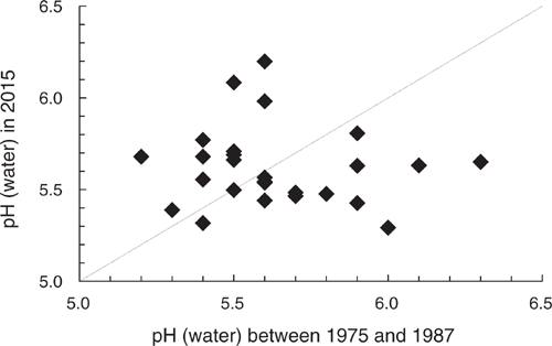
|
Differences in the soil tests could be due to many factors affecting the soil over the intervening four decades. For example, differences may be due to liming, net imports or exports of agricultural materials such as hay, application of alkaline irrigation water, application of ammoniacal acidifying fertilisers or leaching of nitrate derived from mineralised soil N, urine or urea. However, it is likely that for those paddocks determined to be undesirably acidic at the first sampling, the farmer would have received a recommendation to apply lime. It appears that this advice was heeded. In fact, five had recently received lime apparently with varying degrees of success.
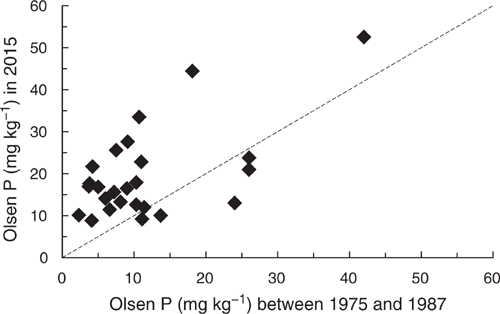
Twenty-five of the 27 paddocks were originally tested for Olsen P. In most cases, the farmer would have been advised to apply P fertiliser given the initial test results. All but five had higher Olsen P results than the initial test results (Fig. 6).
|
Discussion
Drake and Kehoe (1963) provided an early report on the soils in East Gippsland. Spencer and Govaars (1974) followed with a report on the nutrient status of northern East Gippsland. They concluded that East Gippsland soils, ‘Typically, in the virgin state they are slightly to moderately acid, deficient in nitrogen, phosphorus and sulphur, and likely to be deficient in molybdenum and copper. Potassium although adequate in the virgin state, could become deficient in a small proportion of the soils after some years of development’. Since then, scientists, advisors and farmers have worked together to encourage the use of soil testing, and the application of manufactured fertilisers and lime to improve soil fertility. Analysis of routine soil test data from this region for 1973–94 and submitted to the Department of Agriculture (MacLaren et al. 1996; Marchant et al. 2015) suggests that, in general, there has been a decrease in soil pH and an increase in soil K fertility with no change in soil P fertility. The most recent analysis of routine soil testing data from East Gippsland collated for the Audit indicates that paddocks were generally acidic and deficient in P with only a few deficient in K. Although the results reported here are in broad agreement with these previous studies, there are important differences.
Acidity and acidification
It can be interpreted from the differences in the soil pH data from the re-sampled paddocks of the temporal study, that many of the paddocks in this region may now be more acidic than they once were. While such a scenario is to be expected given previous surveys of soil pH changes under pastures in southern Australia (Lewis et al. 1987b; Ridley et al. 1990; Crawford et al. 1994), the results from the re-sampled paddocks and the survey have important implications for long-term management of farm land in East Gippsland. For example, farmers’ choices of plant species have become narrow. Fortunately, this district has several sources of lime, but it is evident that liming practices could be improved given the lack of difference in soil pH between limed and un-limed soils. Moreover, the 2011–12 survey of farm management observed that 44% of farm businesses had never applied or not applied lime since 1 July 2006, and only 16% had applied lime or dolomite in 2011–12 (Australian Bureau of Statistics 2013). This contrasts with the observations of Scott et al. (2007), who provided evidence that liming practices in southern NSW were effective in increasing soil pH. Monitoring of soil pH will be needed to maintain or improve productivity and manage soil acidification.
More broadly, the subtle differences between the legacy data, the data from the re-sampled paddocks and the survey have important implications on the choices of data used to support natural resources management at the regional and state scale. The observations reported here provide evidence that inferences drawn from collated legacy data are potentially misleading. The results show how legacy data may become out-of-date due to ongoing and unaddressed land degradation, for example, soil acidification in this case or where there are differences in the adoption of ameliorative management practices such as liming. Moreover, the observations from the re-sampled paddocks and the observations of Scott et al. (2007) show that analysis of legacy data without pertinent supporting data may not be able to detect multiple disparate trends. The lessons farmers learn from past participation in extension programs and use of soil testing, whether for improving sustainability or productivity, also need to be considered (Lemercier et al. 2008; Gazey et al. 2014; Lobry de Bruyn 2019). Biggs and Searle (2017) have begun a discussion on how to better quantify and describe the quality of the data used to map soil types; an equivalent discussion is needed for data on soil fertility.
Such a discussion would help understand or avoid problematic outcomes. For example, the Audit estimated that the area of acidic soils (pH 4.3–4.8) in Australia’s farm land was 11.3 million ha based on soil survey data, i.e. the data discussed by Biggs and Searle (2017). In contrast, this area was estimated to be 21.2 million ha when based on data from routine soil testing data. The need for this discussion will become more urgent where future sources of data for mapping and monitoring become more diverse, e.g. Robinson et al. (2019).
Phosphorus
Differences in Olsen P between enterprises as observed here (Table 5) are to be expected given the different intensities in management of soil fertility (Table 6). Others have observed how different enterprises have different soil P fertility status (Sparrow et al. 1999; Cotching et al. 2001, 2002a, 2002b; Sparling and Schipper 2004; Wheeler et al. 2004; Roger et al. 2014) although their studies were concerned with excessive application of P, whereas the discussion here is on the inadequacy of application of P.
The widespread deficiency of P in the surveyed paddocks in pastures grazed for meat and wool (Table 5), and the infrequent application of fertiliser (Table 6), is in accord with a survey of farm management in the 2011–12 financial year (Australian Bureau of Statistics 2013), the second year after the end of the Millennium Drought. Only 4% of farm businesses in East Gippsland reported applying P fertiliser in that year. For comparison, this proportion was 18% for Victoria, and 8% in the Murrumbidgee and Murray natural resource management regions which cover the area studied by Scott et al. (2007). Results from our survey (Table 6) would suggest many from East Gippsland who completed the 2011–12 farm management survey and who did not apply P, were meat and wool producers. Moreover, it is evident from Fig. 2 that some local areas may have had little applied P for a substantial period. Therefore, there is a need to understand why farmers were not applying P, how to manage low P soils (Table 4) and why these vary across East Gippsland.
The Olsen P results from the temporal study contrast with the survey results where many paddocks were deficient in P. This contrast both re-emphasises the need for contemporary soil data, rather than relying on legacy data, and supports the value of statistically designed sampling schemes (de Gruijter et al. 2006) rather than approaches based on re-purposing routine soil testing data or offering free soil testing to interested farmers. While statements recognising the inherent bias in datasets based on purposive sampling (Lemercier et al. 2008; Arrouays et al. 2012) may be candid, inferences drawn for an entire study area may be problematic in light of the research reported here. It remains unclear if the few farmers who use soil testing or engage with extension programs adequately represent paddocks managed by those who do not. Data from the Australian Bureau of Statistics (2013) shows that in East Gippsland soil testing was used by 7% of farm businesses and that at most 33% of farm businesses participated in farmer groups in 2011–12. This is further complicated by the findings of Gazey et al. (2014) on the residual effects of lessons learned from past participation in extension programs and the use of soil testing. When Rawlins et al. (2017) compared data from contemporary statistically designed surveys and a large dataset collated from commercial soil testing (n = 143 201), the representativeness of the latter is implied through its size and maps of its extensive coverage of their study area, in this case England, Scotland and Wales. They concluded that collating commercial routine soil testing data has value for monitoring soil resources although they cautioned that such an approach is not a replacement for statistically designed spatio-temporal surveys. The contrast and similarities discussed here suggests that a farmer’s decision to use or not use soil testing or advice on managing soil fertility, cannot be ignored when using approaches that cede control of site selection to the farmer.
How did the trends in soil P fertility arise? Records were not sufficiently complete or accurate to elucidate trends in Olsen P in terms of inputs and outputs of P for each paddock as has been done in other studies, e.g. Lewis et al. (1987a) and Matos-Moreira et al. (2017). An alternative approach is possible. Burkitt et al. (2002) showed how soil test values of Olsen P and Colwell P, from nine sites across the high rainfall zone of Victoria, declined when P fertiliser was not regularly applied. The decline was greater in the more poorly buffered soils of their study, a characteristic shared by many of the soils in our study area. The observations on fertiliser management from this survey (Table 6) showed that paddocks receiving more frequent applications of fertiliser had higher Olsen P values. Therefore, soil testing may well be a better indicator of P management than answers to questionnaires or inferences from secondary sources, e.g. statistics on fertiliser sales. However, this necessitates assuming that the soils of the study area are naturally poor in P, have similar buffering capacities and either assuming that surface soil has not been lost or buried by erosion, or diluted by cultivation. Use of independent quantitative data, e.g. spectral finger printing (Chapman et al. 2013), to demonstrate that the same soil was sampled would be beneficial if affordable.
Potassium
Hosking (1986) reviewed the K nutrition of pastures across Victoria. It was estimated that some 3 million ha of pastures, including those in East Gippsland, were affected by K deficiency at that time. This review presented results from published and unpublished field trials in East Gippsland that showed that pastures responded to K fertilisers including in trials where there were interactions with other fertilisers such as Mo and P, and with lime in virgin soils sown with grass–clover mixes. Published and unpublished fence-line surveys have found many pastures had less available K (Peverill and Briner 1981; Hosking 1986; McGowan 1990) or exchangeable K (Crawford et al. 1995), than in adjacent unfertilised roadsides or native vegetation. This would suggest that agricultural production has in the past exploited K reserves such that the widespread deficiencies may result from not replacing the K removed in agricultural products. In some, soils are naturally deficient in K and agriculture may have exacerbated this condition. However, the results from our survey suggest either that K deficiencies in East Gippsland have since been addressed or that K reserves have not been exploited to the point of being limiting. The Audit reported that East Gippsland is an area of moderate available K (120–200 mg kg−1), that has low K application rate (1–10 kg ha−1 for the 1992–96 period) but with a positive balance of K application (National Heritage Trust (Australia) 2001). The results from the survey reported here accord with the Audit.
Sulfur
Spencer and Govaars (1974) concluded that pasture soils in East Gippsland were deficient in S as was typical of soils in eastern Australia (Williams and Steinbergs 1958). The proportion of deficient paddocks in our 2014–15 survey was in the minority at 16%.
Lewis et al. (1987b) studied changes in total S under subterranean clover-based pastures on sandy texture contrast soils in South Australia after clearing and establishment of permanent pastures. Accumulation rates ranged within 5.9–10.0 kg−1 S ha−1 year−1. They assumed that the accumulating soil S was derived from S applied as superphosphate. However, accession of atmospheric S can be an important source for soils close to the sea as can inundation by estuarine waters. Both may have been an important source of S in some of the paddocks surveyed here.
Micronutrients
There is a dearth of recent reports in the adequacy of micronutrients for pastures and crops in East Gippsland and in Victoria in general. Hosking et al. (1986) summarised available published and unpublished research on pasture responses to micronutrient fertilisers, from across Victoria, including many early reports. They concluded that pastures in East Gippsland were generally deficient in Cu and Mo. They found only two sites in East Gippsland showed responses to the application of Zn whereas three showed depressions and the remaining nine were reported to not have responded to Zn application. Furthermore, they reported that no pastures responded to B application, although B deficiency had been identified in lucerne crops grown in East Gippsland.
Hosking et al. (1986) stated that many pastures have been treated since these micronutrient deficiencies were recognised. Since 1986, there has been little documentation of the application of micronutrients as trace elements in fertilisers in East Gippsland. In our survey, 11 paddocks were reported to have been treated with micronutrients: Zn (n = 6), B (n = 4), Cu (n = 10) and Mo (n = 9), usually as Cu alone, Cu with Mo or a mix of all four. Of those which were tissue tested, only two were reported to have been treated with micronutrients, Cu or Cu and Zn, and neither yielded clover samples that indicated the pasture was deficient in Cu or Zn.
Data from the tissue testing and fertiliser histories reported here suggests the situation has changed since 1986. Many pastures may be deficient in Mo and Cu, and marginal in B. Hamilton et al. (2015) has since provided evidence of B deficiency in the subterranean clover component of pastures of East Gippsland. Their research and the observations reported here suggest that further work on the supply of B and the soil conditions affecting its supply to rhizobia and legumes is warranted in East Gippsland. Given the prevalence of nutrient deficiencies and acidic soil conditions, interactions between soil pH, P, S, Mo, B and nodule function also need to be considered.
Conclusion
Farmland in East Gippsland appears to be generally acidic and deficient in P but not K or S. The most common micronutrient deficiency is in Mo followed by B. Data from the re-tested paddocks and the survey indicates that there are disparate spatial and temporal trends in pH and P and that there are differences between enterprises. This emphasises the importance of having up-to-date soil data with appropriate supporting data. It was concluded, or rather re-learned, that when investigating trends in soil fertility, testing randomly selected paddocks is a preferable source of data compared to re-purposing data collated from routine soil testing laboratories especially if such data is legacy data or data obtained by inviting farmers to submit samples from paddocks for testing. Moreover, it is suggested that salient soil tests may be better indicators of recent paddock management than collecting data from farmers using questionnaires or other indirect indicators.
The widespread deficiencies in P, Mo and B in the strongly acidic soils, combined with many farmers not applying fertilisers, indicates that much pasture production is likely to be low particularly in pastures grazed for meat and wool. This suggests that future natural resources management must separately address farmers who will apply fertilisers to improve productivity, i.e. high-input farming systems, as well as those who have adopted nil or low fertiliser input farming systems.
Conflicts of interest
The authors declare no conflict of interest.
Acknowledgements
Thanks to the 156 farmers who participated in this survey. This research was part of the ‘TopSoils’ project conducted by the East Gippsland Catchment Management Authority, through funding from the Australian Government’s National Landcare Program and Agriculture Victoria’s Land Health program. The project partners who worked on the survey were: the East Gippsland Catchment Management Authority, Far East Victorian Landcare, East Gippsland Landcare Network, Snowy River Interstate Landcare, Southern Farming Systems and Greening Australia, and Agriculture Victoria. East Gippsland Shire Council contributed to the publication of this research. Statistical advice was provided by Sorn Norng, Biometrician, Department of Jobs, Precincts and Regions. Thanks to Keren Walker, John Commins and Neville Fernando (Department of Jobs, Precincts and Regions) for soil sampling and data collation as well as Leo Hamilton for his advice on B deficiency and rhizobia in East Gippsland soils and his historical knowledge that enabled the study of temporal changes in soil fertility.
References
Apted R, Cotter M, Bekker G (2014) Engaging in SoilCare in the Goulburn Broken Catchment. In ‘Soil Change Matters: International Workshop’, 24–27 March 2014. (Ed. R MacEwan) p. 21. (Department of Environment and Primary Industries: Bendigo, Victoria, Australia)Arrouays D, Marchant BP, Saby NPA, Meersmans J, Orton TG, Martin MP, Bellamy PH, Lark RM, Kibblewhite M (2012) Generic issues on broad-scale soil monitoring schemes: a review. Pedosphere 22, 456–469.
| Generic issues on broad-scale soil monitoring schemes: a review.Crossref | GoogleScholarGoogle Scholar |
Australian Bureau of Statistics (2013) 4267.0 – Land Management and Farming in Australia, 2011–12. In ‘Rural environment and agricultural commodities survey.’ (Australian Bureau of Statistics: Canberra, Australia)
Biggs AJW, Searle R (2017) Towards improved quality of soil morphology and analytical data in Australia: starting the discussion. Soil Research 55, 309–317.
| Towards improved quality of soil morphology and analytical data in Australia: starting the discussion.Crossref | GoogleScholarGoogle Scholar |
Brown AJ (1999) Soil sampling and sample handling for chemical analysis. In ‘Soil analysis: an interpretation manual.’ (Eds KI Peverill, LA Sparrow, DJ Reuter) pp. 35–53. (CSIRO Publishing: Collingwood, Australia)
Brown AJ, Fung KKH, Peverill KI (1980) A manual on the soil testing service provided by the Division of Agricultural Chemistry. Technical Report Series No. 34, Government of Victoria, Melbourne, Victoria.
Burkitt LL, Gourley CJP, Sale PWG (2002) Changes in bicarbonate-extractable phosphorus over time when P fertiliser was withheld or reapplied to pasture soils. Soil Research 40, 1213–1229.
| Changes in bicarbonate-extractable phosphorus over time when P fertiliser was withheld or reapplied to pasture soils.Crossref | GoogleScholarGoogle Scholar |
Chapman SJ, Bell JS, Campbell CD, Hudson G, Lilly A, Nolan AJ, Robertson AHJ, Potts JM, Towers W (2013) Comparison of soil carbon stocks in Scottish soils between 1978 and 2009. European Journal of Soil Science 64, 455–465.
| Comparison of soil carbon stocks in Scottish soils between 1978 and 2009.Crossref | GoogleScholarGoogle Scholar |
Cotching WE, Cooper J, Sparrow LA, McCorkell BE, Rowley W (2001) Effects of agricultural management on sodosols in northern Tasmania. Soil Research 39, 711–735.
| Effects of agricultural management on sodosols in northern Tasmania.Crossref | GoogleScholarGoogle Scholar |
Cotching WE, Cooper J, Sparrow LA, McCorkell BE, Rowley W (2002a) Effects of agricultural management on dermosols in northern Tasmania. Soil Research 40, 65–79.
| Effects of agricultural management on dermosols in northern Tasmania.Crossref | GoogleScholarGoogle Scholar |
Cotching WE, Cooper J, Sparrow LA, McCorkell BE, Rowley W (2002b) Effects of agricultural management on tenosols in northern Tasmania. Soil Research 40, 45–63.
| Effects of agricultural management on tenosols in northern Tasmania.Crossref | GoogleScholarGoogle Scholar |
Crawford DM, Baker TG, Maheswaran J (1994) Soil pH changes under Victorian pastures. Australian Journal of Soil Research 32, 105–115.
| Soil pH changes under Victorian pastures.Crossref | GoogleScholarGoogle Scholar |
Crawford DM, Baker TG, Maheswaran J (1995) Changes in soil chemistry associated with changes in soil pH in Victorian pastures. Australian Journal of Soil Research 33, 491–504.
| Changes in soil chemistry associated with changes in soil pH in Victorian pastures.Crossref | GoogleScholarGoogle Scholar |
de Gruijter JJ, Brus DJ, Bierkens M, Knotters M (2006) ‘Sampling for natural resource monitoring.’ (Springer: Berlin, Germany)
Department of Agriculture, Fisheries and Forestry (2014) The National Soil Research, Development and Extension Strategy, Securing Australia’s Soil, For profitable industries and healthy landscapes. (Department of Agriculture, Fisheries and Forestry: Canberra, Australian Capital Territory) Available at https://www.agriculture.gov.au/sites/default/files/style%20library/images/daff/__data/assets/pdffile/0012/2379585/soil.pdf [verified 7 July 2020]
Department of Environment Land Water and Planning (2008) ‘Product Description - Vicmap Elevation DTM 20m, DTM 10m.’ (State Government of Victoria, Melbourne, Victoria) Available at https://www2.delwp.vic.gov.au/maps/spatial-data/victorian-spatial-data [verified 23 June 2020]
Department of Primary Industries (2010) ‘Soils and landforms of the Omeo/Benambra and Tambo Valley region.’ (Department of Primary Industries: Bairnsdale, Victoria)
Department of Primary Industries (2011a) ‘Soils and landforms of Far East Gippsland.’ (Department of Primary Industries: Bairnsdale, Victoria)
Department of Primary Industries (2011b) ‘Soils and landforms of the Bairnsdale and Dargo region.’ (Department of Primary Industries: Bairnsdale, Victoria)
Department of Primary Industries (2011c) ‘Soils and landforms of the Buchan and Suggan Buggan region.’ (Department of Primary Industries: Bairnsdale, Victoria)
Drake FR, Kehoe JK (1963) The East Gippsland region. Land development and pasture improvement. Journal of Agriculture (Department of Agriculture, Victoria) 61, 49–53.
East Gippsland Catchment Management Authority (2013) ‘East Gippsland regional catchment strategy 2013–2019.’ (East Gippsland Catchment Management Authority: Bairnsdale, Victoria)
Gazey C, Oliver Y, Fisher J, Andrew J, Carr S (2014) ‘20 Years of soil acidity RD and E in Western Australia: what have we learnt?’ (Western Australia Department of Agriculture) Available at http://www.giwa.org.au/pdfs/2014/Presented_Papers/Gazey%20Chris_20%20years%20of%20soil%20acidity%20RD%20and%20E%20in%20Western%20AustraliaWhat%20have%20we%20learnt_PAPER%20DR.pdf [verified 19 June 2020].
Hamilton LJ, Reed KFM, Leach EMA, Brockwell J (2015) Boron deficiency in pasture based on subterranean clover (Trifolium subterraneum L.) is linked to symbiotic malfunction. Crop and Pasture Science 66, 1197–1212.
| Boron deficiency in pasture based on subterranean clover (Trifolium subterraneum L.) is linked to symbiotic malfunction.Crossref | GoogleScholarGoogle Scholar |
Helyar KR, Cregan PD, Godyn DL (1990) Soil acidity in New South Wales-current pH values and estimates. Australian Journal of Soil Research 28, 523–537.
| Soil acidity in New South Wales-current pH values and estimates.Crossref | GoogleScholarGoogle Scholar |
Hodge T, Lewis D (1989) A description of acid soils and the relationships between properties of acid soils and the nutrient status of grazed pastures in the southeast of South Australia. Soil Research 27, 149–159.
| A description of acid soils and the relationships between properties of acid soils and the nutrient status of grazed pastures in the southeast of South Australia.Crossref | GoogleScholarGoogle Scholar |
Hosking WJ (1986) ‘Potassium for Victorian pastures: a review.’ (Department of Agriculture and Rural Affairs: Melbourne, Victoria, Australia)
Hosking WJ, Caple IW, Halpin CG, Brown AJ, Paynter DI, Conley DN, North-Coombes PL (1986) ‘Trace elements for pastures and animals in Victoria.’ (Department of Agriculture and Rural Affairs: Melbourne, Victoria, Australia)
Jenkin JJ (1968) ‘The geomorphology and Upper Cainozoic geology of South-East Gippsland, Victoria.’ (Geological Survey of Victoria: Melbourne)
Lemercier B, Gaudin L, Walter C, Aurousseau P, Arrouays D, Schvartz C, Saby NPA, Follain S, Abrassart J (2008) Soil phosphorus monitoring at the regional level by means of a soil test database. Soil Use and Management 24, 131–138.
| Soil phosphorus monitoring at the regional level by means of a soil test database.Crossref | GoogleScholarGoogle Scholar |
Lewis D, Clarke A, Hall W (1987a) Accumulation of plant nutrients and changes in soil properties of sandy soils under fertilized pasture in south-eastern South Australia I. Phosphorus. Soil Research 25, 193–202.
| Accumulation of plant nutrients and changes in soil properties of sandy soils under fertilized pasture in south-eastern South Australia I. Phosphorus.Crossref | GoogleScholarGoogle Scholar |
Lewis D, Clarke A, Hall W (1987b) Accumulation of plant nutrients and changes in soil properties of sandy soils under fertilized pasture in south-eastern South Australia. II. Total sulfur and nitrogen, organic carbon and pH. Soil Research 25, 203–210.
| Accumulation of plant nutrients and changes in soil properties of sandy soils under fertilized pasture in south-eastern South Australia. II. Total sulfur and nitrogen, organic carbon and pH.Crossref | GoogleScholarGoogle Scholar |
Lobry de Bruyn LA (2019) Learning opportunities: Understanding farmers’ soil testing practice through workshop activities to improve extension support for soil health management. Soil Use and Management 35, 128–140.
| Learning opportunities: Understanding farmers’ soil testing practice through workshop activities to improve extension support for soil health management.Crossref | GoogleScholarGoogle Scholar |
MacLaren GS, Crawford DM, Brown AJ (1996) Soil quality and fertility of Victoria’s agricultural soils. In ‘Advances in soil quality for land management: science, practice and policy.’ 17–19 April 1996, University of Ballarat (Eds RJ MacEwan, MR Carter) p. 130. (Centre for Environmental Management, University of Ballarat: Ballarat, Australia)
Marchant BP, Crawford DM, Robinson NJ (2015) What can legacy datasets tell us about soil quality trends? Soil acidity in Victoria. IOP Conference Series: Earth and Environmental Science 25, 012015
| What can legacy datasets tell us about soil quality trends? Soil acidity in Victoria.Crossref | GoogleScholarGoogle Scholar |
Marshall TJ (1947) Mechanical composition of soil in relation to field descriptions of texture. Bulletin No. 224, Council for Scientific and Industrial Research, Australia.
Matos-Moreira M, Lemercier B, Dupas R, Michot D, Viaud V, Akkal-Corfini N, Louis B, Gascuel-Odoux C (2017) High-resolution mapping of soil phosphorus concentration in agricultural landscapes with readily available or detailed survey data. European Journal of Soil Science 68, 281–294.
| High-resolution mapping of soil phosphorus concentration in agricultural landscapes with readily available or detailed survey data.Crossref | GoogleScholarGoogle Scholar |
McGowan AA (1990) Comparative growth of white clover sown into pots of soil from old pastures and adjacent roadsides. Australian Journal of Agricultural Research 41, 1083–1091.
| Comparative growth of white clover sown into pots of soil from old pastures and adjacent roadsides.Crossref | GoogleScholarGoogle Scholar |
Mikhail EH, Briner GP (1978) Routine particle size analysis of soils using sodium hypochlorite and ultrasonic dispersion. Australian Journal of Soil Research 16, 241–244.
| Routine particle size analysis of soils using sodium hypochlorite and ultrasonic dispersion.Crossref | GoogleScholarGoogle Scholar |
National Committee on Soil and Terrain (2009) ‘Australian soil and land survey field handbook.’ (CSIRO Publishing: Collingwood, Victoria)
National Heritage Trust (Australia) (2001) Nutrient Balance in Regional Farming Systems and Soil Nutrient Status: Final report, September 2001. National Land and Water Resources Audit: Turner, Australian Capital Territory.
Natural Heritage Trust (Australia) National Land and Water Resources Audit (2001) ‘Australian Agriculture Assessment 2001, volume 1.’ (National Land and Water Resources Audit: Turner, Australian Capital Territory)
Peverill KI, Briner GP (1981) The effect of previous fertilizer applications and soil type on levels of available phosphorus, sulphur and potassium. Research Project Series No. 51, Department of Agriculture, Victoria.
Peverill KI, Sparrow LA, Reuter DJ (Eds) (1999) ‘Soil analysis: an interpretation manual.’ (CSIRO Publishing: Collingwood, Australia)
Rawlins BG, Marchant B, Stevenson S, Wilmer W (2017) Are data collected to support farm management suitable for monitoring soil indicators at the national scale? European Journal of Soil Science 68, 235–248.
| Are data collected to support farm management suitable for monitoring soil indicators at the national scale?Crossref | GoogleScholarGoogle Scholar |
Rayment GE, Lyons DJ (2011) ‘Soil chemical methods-Australasia.’ (CSIRO Publishing: Collingwood, Australia)
Rees DB (Ed.) (2000) ‘Land systems of Victoria.’ 3rd edn. Technical Report No. 56, Centre for Land Protection Research, Bendigo, Australia.
Reuter DJ, Robinson JB (Eds) (1997) ‘Plant analysis: an interpretation manual.’ 2nd edn. (CSIRO Publishing: Collingwood, Australia)
Ridley A, Helyar K, Slattery W (1990) Soil acidification under subterranean clover (Trifolium subterraneum L.) pastures in north-eastern Victoria. Australian Journal of Experimental Agriculture 30, 195–201.
| Soil acidification under subterranean clover (Trifolium subterraneum L.) pastures in north-eastern Victoria.Crossref | GoogleScholarGoogle Scholar |
Robertson F, Crawford D, Partington D, Oliver I, Rees D, Aumann C, Armstrong R, Perris R, Davey M, Moodie M, Baldock J (2016) Soil organic carbon in cropping and pasture systems of Victoria, Australia. Soil Research 54, 64–77.
| Soil organic carbon in cropping and pasture systems of Victoria, Australia.Crossref | GoogleScholarGoogle Scholar |
Robinson NJ, Dahlhaus PG, Wong M, MacLeod A, Jones D, Nicholson C (2019) Testing the public–private soil data and information sharing model for sustainable soil management outcomes. Soil Use and Management 35, 94–104.
| Testing the public–private soil data and information sharing model for sustainable soil management outcomes.Crossref | GoogleScholarGoogle Scholar |
Roger A, Libohova Z, Rossier N, Joost S, Maltas A, Frossard E, Sinaj S (2014) Spatial variability of soil phosphorus in the Fribourg canton, Switzerland. Geoderma 217–218, 26–36.
| Spatial variability of soil phosphorus in the Fribourg canton, Switzerland.Crossref | GoogleScholarGoogle Scholar |
Sargant J (2009) ‘East Gippsland soil erosion management plan.’ (Department of Primary Industries: Bairnsdale, Victoria)
Scott BJ, Fenton IG, Fanning AG, Schumann WG, Castleman LJC (2007) Surface soil acidity and fertility in the eastern Riverina and Western Slopes of southern New South Wales. Australian Journal of Experimental Agriculture 47, 949–964.
| Surface soil acidity and fertility in the eastern Riverina and Western Slopes of southern New South Wales.Crossref | GoogleScholarGoogle Scholar |
Sparling G, Schipper L (2004) Soil quality monitoring in New Zealand: trends and issues arising from a broad-scale survey. Agriculture, Ecosystems & Environment 104, 545–552.
| Soil quality monitoring in New Zealand: trends and issues arising from a broad-scale survey.Crossref | GoogleScholarGoogle Scholar |
Sparrow LA, Cotching WE, Cooper J, Rowley W (1999) Attributes of Tasmanian ferrosols under different agricultural management. Soil Research 37, 603–622.
| Attributes of Tasmanian ferrosols under different agricultural management.Crossref | GoogleScholarGoogle Scholar |
Spencer K, Govaars A (1974) An assessment of the nutrient status of soils in northern East Gippsland. Australian Journal of Experimental Agriculture 14, 85–92.
| An assessment of the nutrient status of soils in northern East Gippsland.Crossref | GoogleScholarGoogle Scholar |
Theobald DM, Stevens DL, White D, Urquhart NS, Olsen AR, Norman JB (2007) Using GIS to generate spatially balanced random survey designs for natural resource applications. Environmental Management 40, 134–146.
| Using GIS to generate spatially balanced random survey designs for natural resource applications.Crossref | GoogleScholarGoogle Scholar | 17546523PubMed |
Wheeler DM, Sparling GP, Roberts AHC (2004) Trends in some soil test data over a 14-year period in New Zealand. New Zealand Journal of Agricultural Research 47, 155–166.
| Trends in some soil test data over a 14-year period in New Zealand.Crossref | GoogleScholarGoogle Scholar |
Williams CH, Steinbergs A (1958) Sulphur and phosphorus in some eastern Australian soils. Australian Journal of Agricultural Research 9, 483–491.
| Sulphur and phosphorus in some eastern Australian soils.Crossref | GoogleScholarGoogle Scholar |
Zadoks JC, Chang TT, Konzak CF (1974) A decimal code for the growth of cereals. Weed Research 14, 415–421.
| A decimal code for the growth of cereals.Crossref | GoogleScholarGoogle Scholar |