

Aquifer heterogeneity and response time: the challenge for groundwater management
B. F. J. Kelly A B C D I , W. A. Timms A B C E , M. S. Andersen A B C F , A. M. McCallum A B F , R. S. Blakers A C G , R. Smith A H , G. C. Rau B C F , A. Badenhop F , K. Ludowici C F and R. I. Acworth A B C FA Cotton Catchment Communities Cooperative Research Centre.
B Connected Waters Initiative Research Centre.
C National Centre for Groundwater Research and Training, Australia.
D School of Biological, Earth and Environmental Sciences, The University of New South Wales, Sydney, NSW 2052, Australia.
E School of Mining Engineering, The University of New South Wales, Sydney, NSW 2052, Australia.
F Water Research Laboratory, School of Civil and Environmental Engineering, The University of New South Wales, Randwick, NSW 2052, Australia.
G Integrated Catchment Assessment and Management Centre, Fenner School of Environment and Society, Australian National University, Acton, ACT 0200, Australia.
H Ecosystem Management, School of Environmental and Rural Science, University of New England, Madgwick, NSW 2350, Australia.
I Corresponding author. Email: bryce.kelly@unsw.edu.au
Crop and Pasture Science 64(12) 1141-1154 https://doi.org/10.1071/CP13084
Submitted: 11 March 2013 Accepted: 13 September 2013 Published: 6 November 2013
Journal Compilation © CSIRO Publishing 2013 Open Access CC BY-NC-ND
Abstract
Groundwater is an important contributor to irrigation water supplies. The time lag between withdrawal and the subsequent impacts on the river corridor presents a challenge for water management. We highlight aspects of this challenge by examining trends in the groundwater levels and changes in groundwater management goals for the Namoi Catchment, which is within the Murray–Darling Basin, Australia. The first high-volume irrigation bore was installed in the cotton-growing districts in the Namoi Catchment in 1966. The development of high-yielding bores made accessible a vast new water supply, enabling cotton growers to buffer the droughts. Prior to the development of a groundwater resource it is difficult to accurately predict how the water at the point of withdrawal is hydraulically connected to recharge zones and nearby surface-water features. This is due to the heterogeneity of the sediments from which the water is withdrawn. It can take years or decades for the impact of groundwater withdrawal to be transmitted kilometres through the aquifer system. We present the analysis of both historical and new groundwater level and streamflow data to quantify the impacts of extensive groundwater withdrawals on the watertable, hydraulic gradients within the semi-confined aquifers, and the movement of water between rivers and aquifers. The results highlight the need to monitor the impacts of irrigated agriculture at both the regional and local scales, and the need for additional research on how to optimise the conjunctive use of both surface-water and groundwater to sustain irrigated agriculture while minimising the impact on groundwater-dependent ecosystems.
Additional keywords: cotton, ecohydrology, irrigation, groundwater, surface-water, hydrology.
Introduction
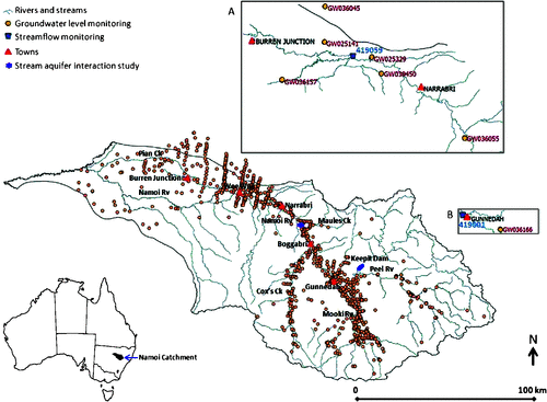
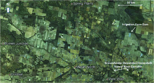
In the Namoi Catchment, Australia (Fig. 1), ~112 000 ha of land is irrigated to grow a variety of crops using a combination of surface-water and groundwater supplies (CSIRO 2007). Most of the irrigated land is used to grow cotton, in rotation with other crops. The area planted changes depending on water availability, due to the highly variable rainfall patterns in the region. For the lower Namoi Catchment (Fig. 2), in the 1998–99 growing season, 82 000 ha of cotton was planted, and this fell to only 20 000 ha in the 2007–08 drought-affected season (Bruce Pyke, pers. comm., Cotton Research and Development Corporation Crops Statistics Records). To monitor the groundwater extractions, an extensive spatial and temporal groundwater-monitoring network has been installed (Fig. 1). Groundwater levels have been monitored since the 1970s, and this provides an ideal opportunity to study the effect of multi-decadal groundwater withdrawals on the watertable, groundwater head in the semi-confined aquifers, and water movement between streams and the underlying aquifers. We focus on the Namoi Catchment where the modern Australian cotton industry was established, but similar impacts are observable in other catchments throughout the Murray–Darling Basin where groundwater is used to support irrigated agriculture. The observations presented have important implications for groundwater development around the world. Wada et al. (2012) recently highlighted that, on a global scale, groundwater use for irrigating crops is not sustainable. We highlight the need to change the way groundwater and surface-water are managed to supply water for irrigating crops.
|
|
In this paper we evaluate the impact of 45 years of groundwater withdrawals by examining trends in 458 groundwater-level monitoring records using 3D plots, correlating streamflow and groundwater hydrographs, and measuring pumping impacts on stream-and-aquifer interactions using a purpose-built monitoring network (Fig. 3). We also discuss the environmental impacts of groundwater extractions, and the goals of protecting groundwater-dependent ecosystems.
|
Historical background
Prior to the development of agriculture in the catchment, over the period of natural climatic cycles the groundwater discharge to streams would have been in a dynamic balance with recharge, with only minor fluctuations in the watertable occurring after floods and extended drought periods. The clearing of trees in the late 1800s and early 1900s was the first major alteration to the water balance (Reid et al. 2007). The large eucalypts, as well as other tree species, can be considered pumps distributed across the landscape, and removal of these trees may have reduced this natural withdrawal of water in the upper 10 m of the subsurface. There are no records of this impact, because the groundwater-monitoring network had not been installed before land clearing.
When the modern Australian cotton industry was established near Wee Waa in New South Wales in the early 1960s, it was reliant on rainfall and surface-water releases from Keepit Dam (Fig. 1). During average and above-average rainfall years, the surface-water supply was adequate to meet the demands of the irrigation sector. However, during drought years, the crops were either low-yielding or failed due to insufficient surface-water resources. In the first 4 years (1961–64) of growing cotton, rainfall was 713, 899, 911, and 966 mm, respectively. These years were wetter than average, as the mean annual rainfall recorded from 1891 through 2012 is 661 mm (Australian Government Bureau of Meteorology, www.bom.gov.au). In 1965, just 438 mm of rainfall was recorded at the Narrabri West Post Office. The relatively poor growing conditions experienced in 1965 encouraged the development of the groundwater resource. In 1966, the first high-volume, gravel-packed and screened bore for the purpose of irrigating cotton was installed on a property near Wee Waa (Courier 1967). Once proven to be economical, the use of groundwater expanded rapidly. In the lower Namoi Catchment (Namoi River reach downstream of Narrabri), where the majority of the cotton is grown, metered groundwater use peaked at ~175 000 ML year–1 in the 1994–95 growing season (DWE 2009). The sustainable yield (locally called the sustainable diversion limit) is estimated to be 86 000 ML year–1 (NSWG 2008; DWE 2009). Staged allocation reductions aim to reach this extraction limit by the 2015–16 growing season.
The fundamentals of the impact of groundwater withdrawals via an irrigation bore (called a well in the quote below) have been comprehensively established since Theis’ ground-breaking analyses in the early 1900s. Theis (1938) wrote:
‘Discharge by wells is a new discharge superimposed on the previous system. Before a new equilibrium can be established water levels must fall throughout the aquifer to an extent sufficient to reduce the natural discharge or increase the recharge by an amount equal to the amount discharged by the well. Until this new equilibrium is established water must be withdrawn from storage in the aquifer and conversely the new equilibrium cannot be established until an amount of water is withdrawn from storage by the well sufficient to depress the piezometric surface enough to change the recharge or natural discharge the proper amount.’ (p. 889)
The above quote applies to an idealised aquifer that is well connected throughout. This idealised conceptualisation of pumping-induced groundwater level decline sets the stage for how people perceive the response of aquifer systems to groundwater withdrawals. When irrigation bores were first installed both farmers and government authorities were aware of the general hydraulic ramifications, but they could not predict with confidence exactly where there would be issues or the timing of impacts on adjacent irrigation bores, rivers, or the end of system discharge.
The fluvial systems that deposited the sediments within the palaeovalley left behind highly heterogeneous lithological sequences, and this complicates the way the aquifer system responds to pumping. Untangling the response of this aquifer system is further complicated by irregular pumping activities, major floods, and changes in groundwater management. The extensive records now enable investigation of the cumulative impacts.
There has been a substantial shift in social attitudes about how groundwater should be allocated and what impacts need to be considered. In the early documents on the development of the water resources of the Namoi Catchment, there is no reference to the impacts of groundwater withdrawals or any discussions about the ecology (Stannard and Kelly 1977).
By the 1980s, it was apparent that if groundwater were to be a long-term viable contributor to water supplies and the environmental impact controlled, then groundwater allocations would have to be altered and enforced. In the 1960s and 1970s, groundwater was allocated according to the area of designated irrigation farmland, and poor records of usage were kept. By the 1980s, this was deemed inadequate for managing the groundwater resource, and in July 1983 a comprehensive volumetric groundwater allocations policy was introduced in the Namoi (WRC 1986).
Despite acknowledgement of the impact of the overdraft on the lower Namoi Catchment alluvial system and embargoes on further development throughout the 1980s, there was still debate about how groundwater should be used. In a document discussing the reassessment of the level of groundwater entitlements and the possibility of releasing additional allocations Ross (1989) wrote:
‘The Department’s allocation philosophy for large alluvial systems such as the Namoi Valley has always been to allocate recharge plus a component of natural storage so that controlled depletion takes place. This means that the resource is seen as a finite resource with a limited life.’ (p. 3)
The complete transition to the goal of using both surface-water and groundwater sustainably, considering both the inter-generational use of groundwater and environmental impacts, was not consolidated until the mid-1990s with the announcement of the COAG water reforms (COAG 1994) and the policy position advice on improved groundwater management (ARMCANZ 1996). It then took another decade for the implementation of the Water Sharing Plan (NSWG 2008), which states:
‘The vision for this Plan is ecologically sustainable groundwater sources that provide an assured supply of quality groundwater for the social and economic benefit of the people in the Namoi Valley.’
One of the significant drivers for change in how groundwater is managed is the increased societal desire to consider the impacts of groundwater use on groundwater-dependent ecosystems (COAG 1994; NSWG 2008). The health of floodplain and riparian eucalypts has been in serious decline in the Namoi Catchment since the droughts of the early 1990s (Kalaitzis et al. 2000). Causes of tree dieback in the region are likely to be complex and attributable to a variety of interacting factors (Reid et al. 2007). Falling watertables resulting from groundwater extraction in the area has been suggested as a potential contributor to the decline in health of trees, in particular, river red gum (Eucalyptus camaldulensis) (Kalaitzis et al. 2000; Banks 2006; Reid et al. 2007; Reardon-Smith 2011). This concern is reflected in the Namoi Catchment Action Plan 2010–2020 (NCAP 2010), which states as a threshold target:
‘By 2020 there is an improvement in the ability of groundwater systems to support groundwater dependent ecosystems and designated beneficial uses.’ (p. 6)
and
‘A particularly important threshold that applies to alluvial aquifers is that the aquifer is never drawn down below historical maximum drawdown.’ (p. 54)
In this paper, we examine the effects of groundwater withdrawals at different locations throughout the Namoi Catchment, both within a kilometre and tens of kilometres away from the river, on the yearly, recovered groundwater level, and on the stream-and-aquifer interaction. We then examine some issues with the use of groundwater-level threshold targets without considering aquifer response time.
Hydrogeology of the Namoi Catchment
Groundwater that supplies the irrigation sector is withdrawn from the alluvial sediments that fill a palaeovalley formed between the late Cretaceous and the mid Miocene (Martin 1980). The palaeovalley was carved through the Cretaceous, Jurassic, Triassic, and Permian sedimentary rocks of the region (Williams et al. 1989). Pollen studies (Martin 1980) indicate that the climate was wetter during the mid to late Miocene when the lower sediments were being deposited. During the Miocene, the region was likely to have received ≥1500 mm of rainfall. This is reflected by the thick sand and gravel beds located at depth, which were deposited in the higher energy, wetter climate. Most of the irrigation groundwater is withdrawn from the sand and gravel units located 50–120 m below the ground surface. During the Pliocene and Pleistocene when the upper 30 m of sediments were deposited, the climate of eastern Australia was becoming drier, and this is reflected by the increase of clay- and silt-rich sediments in the upper 30 m of the unconsolidated sedimentary sequence (Kelly et al. 2012). The unconsolidated sediments are mostly fluvial in origin, although at the margins of the upper Namoi Catchment, there are colluvial deposits, whereas the Vertosol soils common throughout the catchment have an aeolian component (Ward 1999). The unconsolidated sediments are often divided into the Cubberoo (base semi-confined aquifer), Gunnedah (intermediate semi-confined aquifer), and Narrabri (overlying unconfined or phreatic aquifer) Formations (Williams et al. 1989). However, the meandering rivers that deposited the sediments have left a complex heterogeneous architecture, which in places is vertically hydraulically connected at all levels, and in other places is far more complex with many semi-confining layers throughout the vertical sequence. Furthermore, the installation of both irrigation bores and monitoring boreholes with substandard methods may in places have caused artificial vertical hydraulic connectivity through the aquifer systems (NWC 2012; Timms and Acworth 2009). This can locally alter the hydraulic gradients, and the interpretation of aquifer connectivity.
Data, materials, and methods
State government stream and groundwater hydrograph data
The primary historical datasets are the NSW Office of Water Pinneena CM and GW CDs (http://waterinfo.nsw.gov.au/pinneena). These CDs hold the complete public streamflow and groundwater monitoring records for New South Wales. The Pinneena GW CD has details on the coordinates, elevation, construction methods, casing types, slotted intervals, driller lithological logs, and groundwater levels, allowing data to be analysed in 3D. Custom Mathematica scripts (www.wolfram.com) were written to extract and analyse these data. Various state government departments with the responsibility to allocate and monitor groundwater have installed an extensive groundwater monitoring network (presently the NSW Office of Water). Within each groundwater-monitoring borehole, there can be one piezometer or more (locally called pipes). Each pipe is slotted to record the fluctuations in groundwater level for a limited aquifer interval, typically the unconfined aquifer, an intermediate aquifer interval, and near the base of the unconsolidated sediments.
Groundwater is commonly extracted from August to February. When a pump is turned on, groundwater is initially mined from storage and a cone of depression is created around the irrigation bore (Fitts 2013). This is detected as a rapid decline in the groundwater level in neighbouring monitoring boreholes. When the pump is turned off, the groundwater level in the monitoring boreholes recovers. This causes a yearly drawdown and recovery oscillation observable in some groundwater hydrographs. The groundwater-level reading in the non-pumping season, taken in June, July, or August, is called the recovered groundwater level. If the recharge contribution is in balance with the withdrawal impact at the monitoring location, there will be no difference between groundwater levels at the start and end of the pumping year. If there is a fall in the groundwater level, then withdrawals are greater than recharge for the year. This is commonly referred to as the overdraft (Harou and Lund 2008) or depletion (Aeschbach-Hertig and Gleeson 2012).
Trends in the data for groundwater level were analysed using groundwater hydrograph plots, mapping in 3D the multi-decadal change in the recovered groundwater level, plotting a histogram of the change in the groundwater level between 1988 and 2008 for all monitoring locations in the Namoi Catchment, and plotting the median annual change in the winter recovered groundwater level v. groundwater usage in the lower Namoi Catchment.
To identify aquifer regions that are likely to be receiving recharge from the stream, the correlation between the groundwater level recorded in each monitoring borehole and nearby streamflow records was examined. Due to the different response times of the two systems, groundwater levels tend to yield a poor correlation with streamflow. However, the relationship can be improved using the cumulative streamflow departure (CSD) (Blakers et al. 2011), which mimics the gradual response of the groundwater system to changes in flow. This approach is similar to the concept of using the cumulative rainfall departure curve to analyse climatic trends in rainfall (Weber and Stewart 2004). Many groundwater hydrographs throughout the Namoi Catchment display a downward trend due to the long-term effects of groundwater withdrawals. To isolate the recharge response, the hydrographs were linearly rescaled so that yearly maximum groundwater levels at the start and end of the period were equal. Finally, Pearson’s correlation coefficient (r) was calculated for each pair of CSDs and de-trended groundwater time-series, using only those time intervals with complete pairs of observations.
High-frequency stream and groundwater monitoring
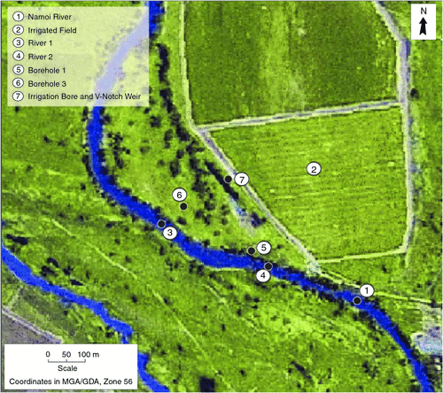
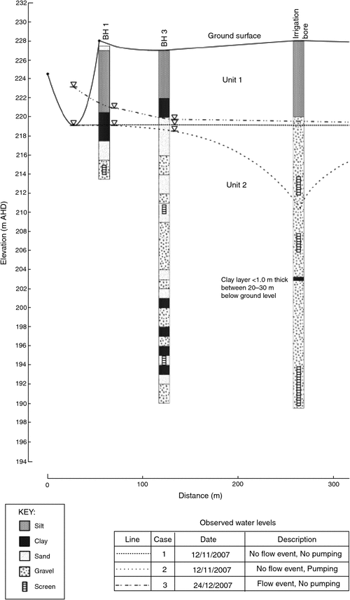
In addition to the long-term regional groundwater and streamflow monitoring described above, a need for high-frequency monitoring of groundwater near streams and rivers was identified. To satisfy this need, several sites were instrumented along the banks of the Namoi River. At one of these sites, observation boreholes were drilled between the Namoi River and the nearby irrigation bore (Fig. 3). Borehole 1 is relatively close to the river (~20 m) and is shallow (12.5 m below ground level; mbgl), and measures the upper phreatic aquifer. Borehole 3, which is further from the river (~70 m), has two deeper piezometers (16.5 and 32.5 mbgl). These boreholes are in a lower, semi-confined aquifer unit. They were drilled with a cable-tool rig and 50-mm piezometers were installed. Aquitard layers were sealed with bentonite and a concrete seal was installed at the surface.
At the same site, the surface-water levels were monitored in the river. Both surface-water and groundwater levels at all sites were monitored by non-vented pressure transducers at 15-min intervals. For correction of barometric variations of the non-vented pressure transducer data, a baro-logger was installed above the watertable in one of the groundwater bores at the site. This high-frequency sampling allowed accurate observations of the groundwater response to pumping and changes in surface-water flow. The pre-existing irrigation bore is further inland, ~200 m from the river (Fig. 3). Records of the screened intervals for this irrigation bore are no longer available, but it is known that withdrawal is from several intervals covering both the upper and lower aquifers (D. Eather, pers. comm.). Pumping periods and rates of withdrawal from this bore were monitored by running the irrigation discharge through a V-notch weir equipped with a pressure transducer.
Results
State government stream and groundwater hydrograph data
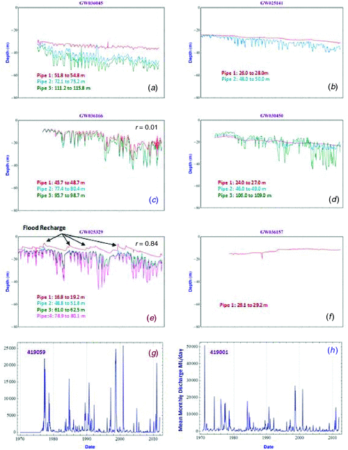
The water levels in the groundwater-level monitoring pipes have been manually recorded ≥4 times per year. Figure 4 shows representative groundwater hydrograph sets recorded at six groundwater-monitoring locations throughout the Namoi Catchment. A consistent scale has been used to give a sense of the change in the groundwater level from site to site. Streamflow records near the boreholes are also presented in Fig. 4.
|
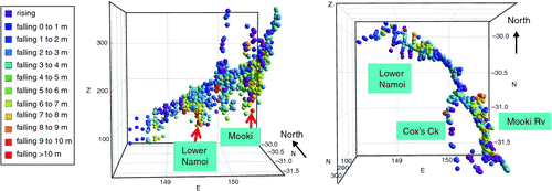
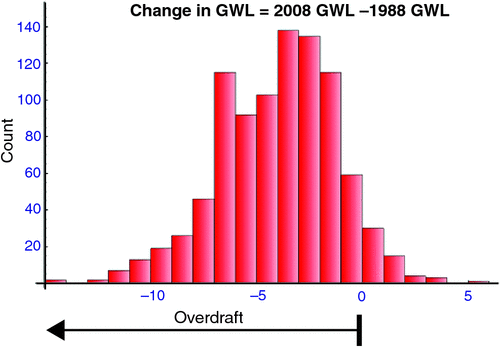
Figure 5 displays the change in the recovered groundwater levels recorded between 1988 and 2008. These years were selected to yield the most complete spatial dataset. The change in the groundwater level was plotted at the midpoint of the slotted interval for each pipe. Figure 6 summarises the results displayed in Fig. 5 as a histogram, and shows that the modal long-term drawdown over the 20-year period from 1988 to 2008 is 4 m. The largest decline was 14.5 m, and the largest rise was 5.5 m.
|
|
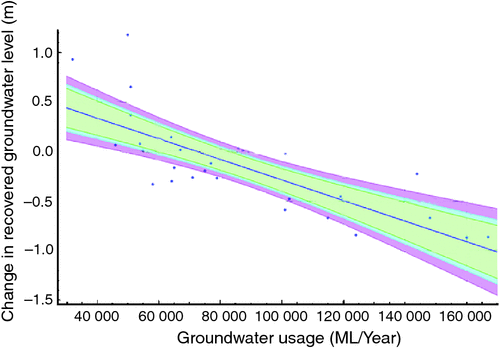
Figure 7 is a cross-plot of the median yearly change in the groundwater level recorded throughout the lower Namoi Catchment v. groundwater usage. Figure 7 shows that for the majority of the years, the groundwater level has fallen. For the lower Namoi Catchment, groundwater-level rise within a year has been as high as 1.2 m due to recharge from floods.
|
Groundwater withdrawals and floods propagate characteristic water-level signals throughout the groundwater and streamflow hydrographs (von Asmuth et al. 2008; Beven 2012). This is clearly observable in Fig. 4e and g. There should also be responses in the groundwater hydrographs due to continuous river leakage, areal (diffuse) rainfall recharge, irrigation return (deep drainage), valley edge (mountain front) recharge, and, in a small portion of the lower Namoi, artesian recharge from the Great Artesian Basin (McLean 2003). On the alluvial plain, areal recharge estimates range from 32 mm year–1 in the Upper Namoi (SWS 2012) to 0 mm year–1 in the western portion of the lower Namoi (Timms et al. 2012). Areal rainfall, irrigation deep drainage (Silburn and Montgomery 2004; Hulugalle et al. 2010, 2012), and valley edge recharge do not cause visually discernible signals in the groundwater hydrographs.
The results of the correlation analysis between the streamflow records and the groundwater level data are displayed in Fig. 8. Positive correlations highlight which reaches of the stream/river network are likely to be hydraulically connected to the underlying aquifers that have a short lag response to streamflow. For bores within 10 km of major streams, 13% have a high correlation (defined as >0.8) and 94% have a positive correlation. For bores >10 km from the major streams, none have a high correlation and 86% have a positive correlation. Note that the small negative correlations recorded at some groundwater-monitoring boreholes are generally not statistically different from zero.

|
High-frequency stream and groundwater monitoring
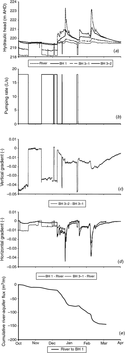
Figure 9a shows the head measurements for a period of 6 months of pumping activity and surface-water and groundwater monitoring (October 2007–April 2008). The monitored period shows features of groundwater withdrawal at low river flow, dam releases (starting mid-December and mid-January), and floods (peaking end of December and in early February). Pumping durations during the irrigation season are shown in Fig. 9b. A clear and rapid response of >1.5 m drawdown to this pumping is seen in the deeper, semi-confined aquifer (borehole 3–2). In the shallow phreatic borehole (borehole 1) closer to the river, a much smaller response is seen; however, changes are still clearly correlated with the pumping. Both borehole locations also show rapid responses to changes in the river level from both dam releases and the floods (Fig. 9a). However, how much of this is related to a transient pressure loading response or to real groundwater recharge is presently not known. Figure 9c shows a time-series of the vertical gradient between the shallow and deep piezometers at borehole 3, which was zero or downward for the entire period. In Fig. 9d the gradient between the river and the upper aquifer and the river and the lower aquifer has been calculated. In both cases, except for very short periods of time, there is a gradient from the river to the aquifers, steeper for the case of the lower aquifer. Furthermore, the cumulative water flux between the river and the upper aquifer has been calculated using a transmissivity of 200 m2 day–1 (from an unpublished aquifer test) (Fig. 9e). This calculation shows that during the monitoring period the river is losing overall, and only very slightly gaining during low river flow, when there are no nearby groundwater withdrawals. This is also illustrated by the representative water level profiles in the vertical cross-section of the site (Fig. 10).
|
|
Discussion
Towards a new equilibrium
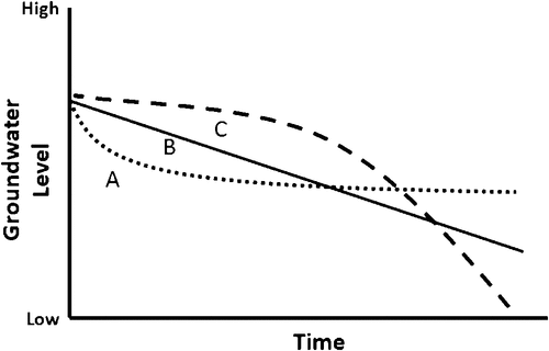
The shape of the decline curve in the groundwater hydrograph plot depends on the type of aquifer from which the groundwater is being withdrawn and the rate of withdrawal (Fitts 2013). In a homogeneous aquifer when there is constant withdrawal, groundwater is initially removed from storage and the zone of depressurisation gradually extends away from the point of pumping (Fitts 2013). In nearby groundwater-monitoring boreholes the groundwater level initially falls rapidly. After a period of time, which depends on the hydrological properties of the sediments, the rate of decline will slow and the groundwater level will asymptotically approach a new equilibrium. This is represented by the curve labelled ‘A’ in Fig. 11. If there is a linear increase in withdrawals the groundwater level declines linearly (curve type ‘B’ in Fig. 11). If there is an exponential increase in withdrawals, then initially there will be a slow decline and then after some years the water level in the monitoring borehole will decline rapidly (line type ‘C’ in Fig. 11) (Soeder et al. 2007). All three styles of declining groundwater level are observable in the Namoi Catchment aquifers. The measured groundwater level recorded in a monitoring borehole reflects the superposition of the effects from multiple points of withdrawal and cumulative recharge contributions; thus, the idealised curves, shown in Fig. 11, are not usually observable. However, the gross trends can be seen.
|
Dynamic equilibrium due to groundwater withdrawals can be defined to have been reached when the impacts in one year are the same as in succeeding years (Kendy and Bredehoeft 2006). The time required for an aquifer system to reach a state of dynamic equilibrium depends upon the hydraulic characteristics of the sediments and the distances from the irrigation bore to the river and flood recharge zones. The groundwater level curves in Fig. 4a for the intermediate (blue) and lower (green) semi-confined aquifers are representative of type A decline due to constant pumping. It took 15 years for the rapid decline to stabilise; however, equilibrium has still not been reached after >40 years of withdrawals, as is evident from the continuing subtle decline. It is apparent in Fig. 4a that there is little leakage between the overlying unconfined aquifer (red) and the underlying semi-confined aquifers at this location.
The groundwater levels in hydrograph set Fig. 4b display nearly linear declines over the period of measurement. Linear declines in the groundwater level can be attributed to an increase in withdrawal with time, which prevents the system from reaching a new equilibrium. At this location, the decline is not due to the impact of a single, nearby pump; rather, it is the result of the superposition of many withdrawals from across the region.
Throughout the Namoi Catchment, there are no examples of type C (continuous, exponentially increasing withdrawal) from the beginning of monitoring until present. However, hydrograph set Fig. 4c is an example of exponentially increasing withdrawal at all levels of the aquifer system for the first 30 years of measurement. The similarity of the curves highlights the good vertical connectivity at this location (this connectivity may be natural via well-connected sand and gravel sheets, or due to the way the monitoring pipes were installed). Since 2004, there has been a partial recovery in the groundwater level.
The 3D plot of the change in the recovered groundwater levels, for the period 1988–2008 (Fig. 5), highlights the large degree of variability in how the aquifer systems of the Namoi Catchment have responded to groundwater withdrawals and variable recharge. Large areas of aquifer overdraft have occurred in the Mooki, Cox’s, and lower Namoi Catchments. The largest declines in groundwater levels have occurred in the lower, semi-confined aquifers; the groundwater level in these aquifers has fallen by greater than 10 m. Such large declines are isolated, as shown in Fig. 6, which highlights that the groundwater level in the majority of the monitoring boreholes has fallen 1–7 m. The extent of the impact of the groundwater overdraft is shown in Fig. 7, which is a plot of the median annual change in the winter recovered groundwater levels v. groundwater usage recorded throughout the lower Namoi Catchment between 1978 and 2008 (the subcatchment with the longest groundwater level record, highest frequency of floods, and largest area of irrigated agriculture in the Namoi Catchment). This plot is used for the Hill Method of determining the ‘safe yield’ of an aquifer (Sophocleous 1998). We note that due to the groundwater monitoring boreholes being concentrated in the region of the irrigation bores, there is a bias towards sampling pumping-influenced areas of the catchment. However, this plot highlights that for most years, more water has been withdrawn from the aquifer systems than is offset by recharge. The existing Water Sharing Plan has set a sustainable yield (locally called the diversion limit) of 86 000 ML year–1 (NSWG 2008; DWE 2009). Figure 7 indicates that under this rate of withdrawal the groundwater level will fall (90% confidence interval), which is to be expected given that groundwater hydrographs in Fig. 4a, b, and d indicate that dynamic equilibrium has not been reached. The sustainable-yield groundwater flow modelling undertaken by CSIRO (2007) indicates that under some climatic scenarios dynamic equilibrium will not be reached within 111 years. Thus, the Namoi Catchment Action Plan 2010–2020 (NCAP 2010) goal of not allowing the groundwater levels to fall cannot be achieved without reducing groundwater withdrawals, or changing the way both surface-water and groundwater are distributed and used throughout the whole of the Namoi Catchment.
In regions where there has been a large fall in the groundwater level (Fig. 5), the downward movement of salts may have been induced (Acworth and Timms 2009). Further research is also required to quantify the extent of salt movement caused by groundwater withdrawals.
Although there has been a clear trend of falling groundwater levels since the beginning of the groundwater withdrawals in the 1960s for the majority of the Namoi Catchment (Figs 4 and 5), there are isolated places where the groundwater level is rising. Between the Namoi River and Burren Junction, a cluster of groundwater hydrographs displays a slight rise in the groundwater level. Most rises are <1 m, but they can be as high as 2 m (Figs 4f and 5). In this region, there are limited groundwater withdrawals. The rising water levels are probably due to a combination of factors, including leakage from on-farm dams, deep drainage beneath irrigated crops, and the removal of large eucalyptus trees. The exact contribution of each factor is unknown.
There is a need to better understand the impact of rising groundwater levels in the headwaters of all catchments, and in the south-west of the lower Namoi Catchment (Fig. 5). This may have future ramifications for the mobilisation of salts in the near-surface soils.
In the lower Namoi Catchment between 1988 and 2008, there was a system-wide increase of groundwater levels of >0.25 m in only 4 years (Figs 6 and 7). These correspond to the wetter growing seasons 1994–95 and 1996–97, and flood years 1998 and 2000.
In a few locations there has been groundwater head reversal between the upper and lower portions of the aquifer system. The initial higher head in the lower semi-confined aquifer is due to upward pressure from the underlying Great Artesian Basin (SWS 2012; N. Merrick, pers. comm.). When the semi-confined aquifer is depressurised, the groundwater level in the semi-confined aquifer-monitoring borehole falls faster than in the overlying unconfined aquifer. This can be observed in Fig. 4d.
Water movement between streams and aquifers
Between Narrabri and Wee Waa there is a cluster of monitoring pipes near the Namoi River that are hydraulically connected to the floodwater recharge zones (Kelly et al. 2009; Blakers et al. 2011; Lamontagne et. al. 2013). Figure 4e is typical of such groundwater hydrographs where there is good flood recharge. Between floods the groundwater level slowly declines, and the yearly pumping drawdown increases from year to year in the semi-confined aquifers; this reflects the reduction in the amount of water in storage throughout the pumping capture zone. A strong correlation between floods and the groundwater level is observable by comparing the peaks in the groundwater hydrograph Fig. 4e and the nearby streamflow hydrograph Fig. 4g.
Throughout most of the lower reaches of the Mooki River, Peel River, and Cox’s Creek, and the Namoi River from Boggabri to south of Burren Junction, there is a strong association between streamflow and groundwater level for the unconfined aquifer monitoring boreholes within 10 km of the streams or rivers (Fig. 8). The proportion of the groundwater-level rise that is due to loading v. actual recharge cannot be determined from the time-series analysis (van der Kamp and Maathuis 1991; Maliva et al. 2011). The results suggest that there is an opportunity to enhance recharge with a series of weirs. However, we acknowledge that this may have implications for streamflow and river ecology.
There was poor correlation between streamflow and the measured groundwater levels in the upper reaches of all rivers and streams, probably due to the low number of streamflow-gauging stations in these regions. There is also poor correlation between streamflow and the groundwater levels in the northern and western portions of the lower Namoi Catchment. This is most likely due to the distance between the Namoi River and the monitoring boreholes (>10 km); thus, the potential groundwater level changes from dam releases and floods are significantly dampened in these regions (Kelly et al. 2009, 2012).
The high-frequency monitoring of surface-water and groundwater near the riverbank of the Namoi River shows a dynamic response to both floods and groundwater withdrawal (Figs 9 and 10). It could be argued from these data that the response of the shallow groundwater near the river due to pumping is not obvious, due to the existence of low-permeable units between the shallow river alluvium and the irrigation bore (Fig. 10). However, there is evidence of a small response in the shallow alluvium, which, together with the development of increased vertical downward gradients, indicates that a long-term, sustained leakage could be induced from the upper aquifer, thereby indirectly affecting the river flows. This sustained and potentially substantial long-term recharge from the river into the aquifer was also seen in studies of the Namoi River in the Maules Creek subcatchment by Andersen and Acworth (2009), Giambastiani et al. (2012), and McCallum et al. (2013a, 2013b).
River recharge may further increase in the future if the current groundwater extraction level is maintained. The slow leakage from the upper to the lower aquifer, observable in Fig. 9, means there is a delay in the impact of the groundwater withdrawal on the surface-water resource. Such delays pose a challenge for water-management policies that are based on monitoring sustainable surface-water indicators in the present.
Furthermore, the change in the direction of water exchange between river and aquifers may have severe impacts on the river flow during prolonged drought periods where the losing conditions may affect the river’s resilience to drought (i.e. the ability of a sustained natural groundwater discharge in providing baseflow through drought periods; McCallum et al. 2013a). The full ecological impact of the loss of this resilience is yet to be seen.
Groundwater management challenges
Balancing ecological management goals in a catchment where groundwater is a major resource is a difficult challenge. As shown by the multi-decadal, catchment-scale analysis of groundwater level, aquifer drawdown is greatest in regions remote from the river, whereas the small-scale study of pumping impacts demonstrates the immediate influence on groundwater levels due to pumping near the river.
The time to impact from bores ≥20 km away from the groundwater-dependent ecosystems in the corridor near the Namoi River is in the order of decades (Sophocleous 2012). Applying groundwater-level thresholds with reference to historical groundwater levels will not achieve the goal of protecting or improving the groundwater-dependent ecosystems in the river corridor within 10 years. By contrast, bores within 1–2 km of the river have been demonstrated to have a measurable short-term impact on streamflow, and must capture some of the recharge that would otherwise migrate to the more distal portions of the catchment. These bores are unlikely to trigger threshold reductions, because when it floods the groundwater level in the river corridor recovers.
Today there is consensus that groundwater-dependent ecosystems should be protected, and in places remediated. This is clearly reflected in the threshold goals of the Namoi Catchment Action Plan 2010–2020 (NCAP 2010). It is apparent from the results presented here that there is a need for local area management of water within the context of the regional Water Sharing Plans and Catchment Action Plans. The semi-confined aquifers of the central portion of the Mooki Catchment and the western and northern portions of the lower Namoi Catchment are poorly connected to the river and flood recharge pathways, as indicated by the large drawdowns in these regions and the lack of a response to floods. Continued pumping in these regions, at volumes close to those allocated under the active Water Sharing Plan (NSWG 2008), must cause the local groundwater level to fall further, because the groundwater systems at these locations have not yet reached a new dynamic equilibrium.
Aquifers store water in an evaporation-free environment, and as discussed by Bredehoeft (2011), there can be an advantage to using groundwater remote from the river. It provides an insurance against drought, and if used when there is low flow in the river, it can delay the impact of using groundwater on the riparian corridor. During wet periods, the use of groundwater from bores far from the river can be replaced by sourcing water supplies from boreholes near the river or directly from the river. Groundwater is an important source of water for irrigating crops, but if groundwater is allocated and managed only in the context of point of use, or in assumed isolation from surface-water, sustainable access to groundwater for all existing irrigation farms will be difficult to attain while minimising the impact on groundwater-dependent ecosystems. This will only be achieved if surface-water and groundwater are managed as a single resource at the catchment scale. In conjunctive water-use plans, consideration needs to be given to the response time between the point of groundwater withdrawal and points of impact. The time to the establishment of a new dynamic equilibrium due to groundwater withdrawals needs to be considered in water-management policies and plans. The fundamentals of groundwater hydraulics were mostly well understood in the early 1900s, but as highlighted in this case study, further research is required on how best to balance the use of groundwater and surface-water to support irrigated agriculture, while protecting groundwater-dependent ecosystems.
Conclusions
When groundwater resources are initially developed, the water is mined from storage. In the Namoi Catchment it took two decades from the start of pumping before there were sufficient data to enable the mapping of pathways of connectivity, and to allow an assessment of the impacts of groundwater withdrawal in a complex sedimentary setting. An analysis of both groundwater and streamflow hydrographs shows good hydraulic connectivity throughout the unconfined aquifer system extending up to 10 km perpendicular to the Namoi River. Beyond that distance, there is little or no discernible streamflow/flood recharge signature in the groundwater hydrographs detected from signal correlation.
The detailed high-frequency stream-level and groundwater-level monitoring showed that the stream-and-aquifer interactions are highly dynamic and change rapidly with the onset of groundwater pumping, during flooding, and with water releases from upstream dams. This highlights that, to get a better understanding of these processes, we need more dedicated monitoring at a higher frequency along other reaches of the river network. At the site investigated, the impact of the groundwater withdrawal on the streamflow was delayed by the presence of aquitards between the deeper aquifer, from which the water is being sourced, and the shallower aquifer that is directly connected to the river. However, the reduced heads in the lower aquifer will eventually lead to a depletion of the river baseflow. On a wider catchment scale, this has caused the Namoi River in the Maules Creek subcatchment as well as other areas to change from gaining to losing as a direct consequence of the groundwater withdrawals used in irrigated agriculture over the last decade. One of the primary results from this research is the extent to which the Namoi River has switched from gaining to losing water, and this supports and extends the findings of Giambastiani et al. (2012) and McCallum et al. (2013a).
The results presented in this paper show that further research is required on the delivery and usage of water, at different times and to different locations, to achieve both goals of supporting irrigated agriculture and protecting groundwater-dependent ecosystems. This can be more readily achieved if surface-water and groundwater are managed as a single resource at the catchment scale. We now have enough knowledge of the effects of groundwater withdrawals and their impacts on groundwater level, and on stream-and-aquifer interaction. This facilitates research opportunities on optimising the conjunctive use of surface-water and groundwater, while considering the ecological impacts.
Acknowledgements
This research was funded by the Cotton Catchment Communities CRC, National Water Commission, Namoi Catchment Management Authority, Cotton Research and Development Corporation, and National Centre for Groundwater Research and Training. We thank the reviewers for their constructive comments.
References
Acworth RI, Timms WA (2009) Evidence for connected water processes through smectite-dominated clays at Breeza, New South Wales. Australian Journal of Earth Sciences 56, 81–96.| Evidence for connected water processes through smectite-dominated clays at Breeza, New South Wales.Crossref | GoogleScholarGoogle Scholar | 1:CAS:528:DC%2BD1MXkvVWks7c%3D&md5=56d5b6cf7cea4719a53fd3cbed373a07CAS |
Aeschbach-Hertig W, Gleeson T (2012) Regional strategies for the accelerating global problem of groundwater depletion. Nature Geoscience 5, 853–861.
| Regional strategies for the accelerating global problem of groundwater depletion.Crossref | GoogleScholarGoogle Scholar | 1:CAS:528:DC%2BC38Xhs1ymt7zO&md5=34f65f7a374df2e03e32ee0f2f7f8d99CAS |
Andersen MS, Acworth RI (2009) Stream-aquifer interactions in the Maules creek catchment, Namoi Valley, NSW, Australia. Hydrogeology Journal 17, 2005–2021.
| Stream-aquifer interactions in the Maules creek catchment, Namoi Valley, NSW, Australia.Crossref | GoogleScholarGoogle Scholar |
ARMCANZ (1996) ‘A national framework for improved groundwater management in Australia.’ (Agriculture and Resource Management Council of Australia and New Zealand, Standing Committee on Agriculture and Resource Management: Canberra, ACT)
Banks V (2006) An investigation of eucalypt dieback on the northern Liverpool Plains, NSW. PhD Thesis, Ecosystem Management, University of New England, Armidale, NSW, Australia.
Beven KJ (2012) ‘Rainfall runoff modelling: The primer.’ 2nd edn (Wiley-Blackwell: Hoboken, NJ)
Blakers RS, Kelly BFJ, Anderssen R, Mariethoz G, Timms W (2011) 3D dendrogram analysis for mapping aquifer connectivity and flow model structure. In ‘MODFLOW and More 2011: Integrated Hydrologic Modeling’. Colorado School of Mines, Golden, Colorado, 5–8 June 2011. (IGMC, Colorado School of Mines: Golden, CO)
Bredehoeft J (2011) Hydrologic trade-offs in conjunctive use management. Ground Water 49, 468–475.
| Hydrologic trade-offs in conjunctive use management.Crossref | GoogleScholarGoogle Scholar | 1:CAS:528:DC%2BC3MXptVCht78%3D&md5=68ed43a89d106eff3f97d9939b8fdd5eCAS | 20880041PubMed |
COAG (1994) ‘The Council of Australian Governments’ Water Reform Framework.’ (Department of the Environment: Canberra, ACT)
Courier (1967) Groundwater in N.S.W.: drilling methods bring spectacular yield increases. In ‘Rural Forum for Applied Research’. Supplement to the North Western Courier, Narrabri, December 11, 1967, Vol. 1, No. 6.
CSIRO (2007) Water availability in the Namoi. A report to the Australian Government from the CSIRO Murray–Darling Basin sustainable yields project. CSIRO Land and Water, Canberra, ACT.
DWE (2009) Lower Namoi groundwater source: groundwater management area 001. Groundwater Status Report 2008. New South Wales Government, Department of Water & Energy, Sydney, NSW.
Fitts CR (2013) ‘Groundwater Science.’ 2nd edn (Elsevier: Amsterdam)
Giambastiani BMS, McCallum AM, Andersen MS, Kelly BFJ, Acworth RI (2012) Understanding groundwater processes by representing aquifer heterogeneity in the Maules creek catchment, Namoi valley (New South Wales, Australia). Hydrogeology Journal 20, 1027–1044.
| Understanding groundwater processes by representing aquifer heterogeneity in the Maules creek catchment, Namoi valley (New South Wales, Australia).Crossref | GoogleScholarGoogle Scholar |
Harou JJ, Lund JR (2008) Ending groundwater overdraft in hydrologic-economic systems. Hydrogeology Journal 16, 1039–1055.
| Ending groundwater overdraft in hydrologic-economic systems.Crossref | GoogleScholarGoogle Scholar |
Hulugalle NR, Weaver TB, Finlay LA (2010) Soil water storage and drainage under cotton-based cropping systems in a furrow-irrigated Vertisol. Agricultural Water Management 97, 1703–1710.
| Soil water storage and drainage under cotton-based cropping systems in a furrow-irrigated Vertisol.Crossref | GoogleScholarGoogle Scholar |
Hulugalle NR, Weaver TB, Finlay LA (2012) Soil water storage, drainage, and leaching in four irrigated cotton-based cropping systems sown in a Vertosol with subsoil sodicity. Soil Research 50, 652–663.
| Soil water storage, drainage, and leaching in four irrigated cotton-based cropping systems sown in a Vertosol with subsoil sodicity.Crossref | GoogleScholarGoogle Scholar |
Kalaitzis P, Banks R, Banks V, Merrick N (2000) Optimising ground water usage to mitigate native vegetation decline in the Namoi Valley, NSW. Phase 1. Eco-physiological investigations. Technical Report. Department of Land and Water Conservation, Gunnedah, NSW.
Kelly BFJ, Allen D, Ye K, Dahlin T (2009) Continuous electrical imaging for mapping aquifer recharge along reaches of the Namoi River in Australia. Near Surface Geophysics 7, 259–270.
Kelly BFJ, Giambastiani B, Larsen J, Ralph T, Timms W, Baker A (2012) Palaeoclimate impacts on aquifer architecture and hydraulic connectivity. In ‘38th Symposium on the Advance in the Study of the Sydney Basin’. 10–11 May, Mercure Resort Pokolbin. (NSW Trade and Investment: Sydney, NSW)
Kendy E, Bredehoeft JD (2006) Transient effects of groundwater pumping and surface-water returns on streamflow. Water Resources Research 42, W08415
| Transient effects of groundwater pumping and surface-water returns on streamflow.Crossref | GoogleScholarGoogle Scholar |
Lamontagne S, Taylor AR, Cook PG, Crosbie RS, Brownbill R, Williams RM, Brunner P (2013) Field assessment of surface water-groundwater connectivity in a semi-arid river basin (Murray–Darling, Australia). Hydrological Processes
| Field assessment of surface water-groundwater connectivity in a semi-arid river basin (Murray–Darling, Australia).Crossref | GoogleScholarGoogle Scholar |
Maliva RG, Coulibaly K, Guo W, Missimer TM (2011) Confined aquifer loading: Implications for groundwater management. Ground Water 49, 302–304.
| Confined aquifer loading: Implications for groundwater management.Crossref | GoogleScholarGoogle Scholar | 1:CAS:528:DC%2BC3MXmtV2qu7s%3D&md5=8d705573d1a0ecbe5870d2d3bee718caCAS | 21087252PubMed |
Martin H (1980) Stratigraphic palynology from shallow bores in the Namoi river and Gwydir river valleys north-central New South Wales. Journal and Proceedings of the Royal Society of New South Wales 113, 81–87.
McCallum AM, Andersen MS, Giambastiani BMS, Kelly BFJ, Acworth RI (2013a) River-aquifer interactions in a semi-arid environment stressed by groundwater abstraction. Hydrological Processes 27, 1072–1085.
| River-aquifer interactions in a semi-arid environment stressed by groundwater abstraction.Crossref | GoogleScholarGoogle Scholar |
McCallum AM, Andersen MS, Acworth RI (2013b) A new method for estimating recharge to unconfined aquifers using differential river gauging. Ground Water,
| A new method for estimating recharge to unconfined aquifers using differential river gauging.Crossref | GoogleScholarGoogle Scholar | 23550897PubMed |
McLean WA (2003) Hydrogeochemical evolution and variability in a stressed alluvial aquifer system: Lower Namoi River Catchment, NSW. PhD Thesis, School of Biological, Earth and Environmental Sciences, University of New South Wales, Sydney, NSW, Australia.
NCAP (2010) Namoi Catchment Action Plan 2010–2020., Namoi Catchment Management Authority, New South Wales Government, Gunnadah, NSW. Available at: www.namoi.cma.nsw.gov.au/9652_namoi_cma_cap____web_1.pdf
NSWG (2008) Water Sharing Plan for the Upper and Lower Namoi Groundwater Sources 2003. NSW Legislation, New South Wales Government, Sydney, NSW. Available at: www.legislation.nsw.gov.au/viewtop/inforce/subordleg+1035+2002+FIRST+0+N/
NWC (2012) An assessment of groundwater management and monitoring costs in Australia. Waterlines Report by Sinclair Knight Merz for the National Water Commission, Canberra. Available at: http://archive.nwc.gov.au/__data/assets/pdf_file/0013/23314/FINAL-for-publishing-Assessment-of-groundwater-management-costs.pdf
Reardon-Smith K (2011) Disturbance and resilience in riparian woodlands on the highly-modified upper Condamine floodplain. PhD Thesis, Faculty of Sciences, University of Southern Queensland, Toowoomba, Qld, Australia.
Reid N, Nadolny C, Banks V, O’Shea G, Jenkins B (2007) Causes of Eucalypt tree decline in the Namoi Valley, NSW. Final Report to Land and Water Australia, Project UNE 42. University of New England, Armidale, NSW, Australia.
Ross J (1989) Reassessment of the level of groundwater entitlements, lower Namoi valley, NSW. Discussion Paper TS 89.060, November 1989. NSW Department of Water Resources, Technical Services Division, Hydrogeology Unit, Sydney, NSW.
Silburn DM, Montgomery J (2004) ‘Deep drainage under irrigated cotton in Australia – A review. WATERpak—a guide for irrigation management in cotton.’ Section 2.4, pp. 29–40. (Cotton Research and Development Corporation/Australian Cotton Cooperative Research Centre: Narrabri, NSW)
Soeder DJ, Raffensperger JP, Nardi MR (2007) Effects of withdrawals on ground-water levels in Southern Maryland and the adjacent Eastern Shore, 1980–2005. Report 2007–5249. U.S. Geological Survey Scientific Investigations, Reston, VA, USA.
Sophocleous M (1998) On the elusive concept of safe yield and the response of interconnected stream-aquifer systems to development. In ‘Perspectives on Sustainable Development of Water Resources in Kansas’. Kansas Geological Survey, Bulletin No. 239. (Ed. MA Sophocleous) pp. 6–85.
Sophocleous M (2012) On understanding and predicting groundwater response time. Ground Water 50, 528–540.
| On understanding and predicting groundwater response time.Crossref | GoogleScholarGoogle Scholar | 1:CAS:528:DC%2BC38XhtFSgu77O&md5=5c137c239929984a6942c3a359312bd6CAS | 22023718PubMed |
Stannard ME, Kelly ID (1977) ‘The irrigation potential of the lower Namoi valley.’ (Water Resources Commission: Sydney, NSW)
SWS (2012) Namoi Catchment water study independent expert final study report. Report No. 50371/P4–R2 FINAL. Prepared for Department of Trade and Investment, Regional Infrastructure and Services, New South Wales. Schlumberger Water Services (Australia) Pty Ltd. Available at: www.namoicatchmentwaterstudy.com.au/site/index.cfm?display=317529
Theis CV (1938) The significance and nature of the cone of depression in ground-water bodies. Economic Geology and the Bulletin of the Society of Economic Geologists 33, 889–902.
| The significance and nature of the cone of depression in ground-water bodies.Crossref | GoogleScholarGoogle Scholar |
Timms WA, Acworth RI (2009) Quantifying the potential impact of leaky boreholes. In ‘Groundwater in the Sydney Basin. Proceedings of IAH NSW Symposium’. 4–5 August 2009. (Ed. W Milne-Home) (International Association of Hydrologists NSW)
Timms WA, Young RR, Huth N (2012) Implications of deep drainage through saline clay for groundwater recharge and sustainable cropping in a semi-arid catchment, Australia. Hydrology and Earth System Sciences 16, 1203–1219.
| Implications of deep drainage through saline clay for groundwater recharge and sustainable cropping in a semi-arid catchment, Australia.Crossref | GoogleScholarGoogle Scholar | 1:CAS:528:DC%2BC38Xht1WksLzO&md5=b3942626ce28095ba294b780c55e9897CAS |
van der Kamp G, Maathuis H (1991) Annual fluctuations of groundwater levels as result of loading by surface moisture. Journal of Hydrology 127, 137–152.
| Annual fluctuations of groundwater levels as result of loading by surface moisture.Crossref | GoogleScholarGoogle Scholar |
von Asmuth JR, Maas K, Bakker M, Petersen J (2008) Modeling time series of groundwater head fluctuations subjected to multiple stresses. Ground Water 46, 30–40.
Wada Y, van Beek LPH, Bierkens MFP (2012) Nonsustainable groundwater sustaining irrigation: A global assessment. Water Resources Research 48, W00L06
| Nonsustainable groundwater sustaining irrigation: A global assessment.Crossref | GoogleScholarGoogle Scholar |
Ward WT (1999) Soils and landscapes near Narrabri and Edgeroi, NSW, with data analysis using fuzzy k-means. Technical Report No. 22/99. CSIRO Land and Water, Canberra, ACT.
Weber K, Stewart M (2004) A critical analysis of the cumulative rainfall departure concept. Ground Water 42, 935–938.
| A critical analysis of the cumulative rainfall departure concept.Crossref | GoogleScholarGoogle Scholar | 1:CAS:528:DC%2BD2cXpsF2rtrg%3D&md5=bf79aaaf8274db7e79b5eeae8305499bCAS | 15584306PubMed |
Williams RM, Merrick NP, Ross JB (1989) Natural and induced recharge in the lower Namoi Valley, New South Wales. In ‘Proceedings of the Symposium on Groundwater Recharge’. Mandurah, 6–9 July 1987. (Ed ML Sharma) pp. 239–253. (A.A. Balkema: Rotterdam/Brookfield)
WRC (1986) ‘Review of the volumetric licensing policy for high yield bores in the lower Namoi valley. NSW.’ (Hydrogeological Section, Water Resources Commission: Sydney, NSW)