

Development of a 3D continental chronostratigraphic framework for energy, minerals and groundwater integrated assessments
Nadege Rollet A * , John Vizy A , Catherine Norton B and Carey Hannaford CA
B
C

Nadege Rollet, a Senior Geoscientist at Geoscience Australia with over 20 years of experience and an MSc and PhD from the University of Paris, has worked on petroleum, CO2 storage, seepage and groundwater studies. She now leads the development of a 3D national geological and hydrogeological framework. |

John Vizy, a 3D Geological Modeller and Data Analyst at Geoscience Australia, specialises in GIS mapping, geological modelling, and data integration. Previously at Frogtech Geoscience, he contributed to SEEBASE GIS products. He now develops national models to advance geological and hydrogeological understanding. |

Catherine Norton, a Senior Geoscientist with over 30 years of experience in petroleum, now consults with Geoscience Australia. She holds an MSc in Petroleum Geology and Geophysics from the University of Adelaide. |

Carey Hannaford, a Palynologist at MGPalaeo with over 20 years of experience in the oil, gas and minerals industry, specialises in biostratigraphy, sequence stratigraphy and petroleum exploration. |
Abstract
Understanding the chronostratigraphy of geological units is crucial for the transition to net zero by providing a 4D framework (three-dimensions through geological time) to assess potential energy and mineral resources, groundwater systems and storage sites for carbon dioxide and hydrogen. Integrating geological and hydrogeological data into a unified national 3D framework enhances decision-making across government, industry and communities for sustainable resource management, supports environmental approvals and cross-jurisdictional collaboration. Geoscience Australia’s former Exploring for the Future program and current Resourcing Australia’s Prosperity Initiative have advanced 3D conceptualisation of Australia’s sedimentary basins and groundwater systems, standardising stratigraphy and terminology across basins and jurisdictional borders. This enabled consistent 3D geological models revealing potential connections between geological units, reservoirs and aquifers. The integration of airborne electromagnetic and seismic data, with drillhole stratigraphy within a consistent national 3D chronostratigraphic framework underpins depth estimates for the nationwide Estimates of Geological and Geophysical Surfaces database. Collaboration with the jurisdictions harmonised 3D geology, focussing initially on updating aquifer boundaries in a groundwater context. The overarching goal is to improve national geological and groundwater datasets to support integrated management of energy, minerals, and groundwater resources. A key achievement is the national-scale 3D chronostratigraphic surface modelling, based on the Australian Borehole Stratigraphic Units Compilation, consolidating data from 53 sources and 171,396 drillholes. Ongoing refinement of subsurface geology is fundamental for resource potential mapping, multi-commodity assessments, and 3D visualisation, supporting the global energy transition, climate resilience, and water security for communities, industries and the environment.
Keywords: 3D geological models, airborne electromagnetic data, Australia’s groundwater systems, borehole stratigraphy, chronostratigraphy, national consistent framework, potential for critical minerals and strategic materials and geological storage of hydrogen and carbon dioxide, seismic reflection data, subsurface geological mapping.
Introduction
Integrated and multidisciplinary geoscience is essential for the global transition to net zero and sustainability, enabling efficient resource assessment and management. Depth-based 3D geoscience data assists in discovering energy and mineral resources, understanding groundwater systems and identifying CO2 and hydrogen storage sites. A unified continent-wide chronostratigraphic framework ensures consistent geological mapping across Australia’s diverse and interconnected onshore and offshore resources.
Geoscience Australia has advanced 3D mapping of sedimentary basins and aquifers using a regional chronostratigraphic framework (Fig. 1), supporting sustainable resource management and environmental impact assessments. This aligns with the Australian Government’s former Exploring for the Future (EFTF) program and the current Resourcing Australia’s Prosperity Initiative, a 35-year AU$3.4 billion investment in precompetitive geoscience to drive exploration, discoveries and responsible resource management.
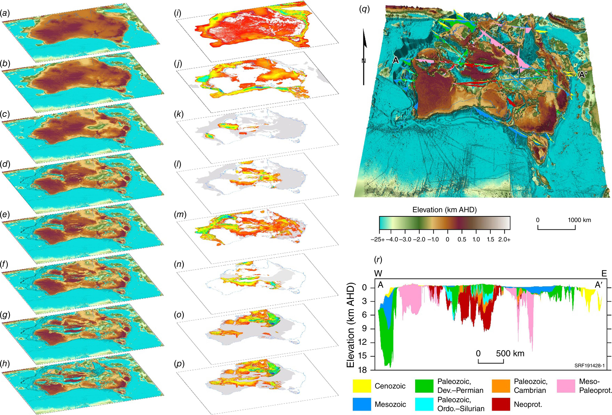
Three-dimensional chronostratigraphic model of Australia. Surfaces: (a) DEM, (b) Base Cenozoic, (c) Base Mesozoic, (d) Base Devonian, (e) Base Ordovician, (f) Base Cambrian, (g) Base Neoproterozoic, (h) Base Paleoproterozoic. Isochores: (i) Cenozoic, (j) Mesozoic, (k) Ordovician–Silurian, (l) Cambrian, (m) Paleozoic, (n) Neoproterozoic, (o) Pre-Neoproterozoic, (p) Proterozoic. Gray indicates extent of unknown thickness. (q) Example of modelled cross-sections displayed over the Basement (Base Paleoproterozoic) surface. (r) Individual cross-section A–A′.
Using sequence stratigraphy principles, this approach integrates diverse frameworks into detailed 3D geological models, enhancing understanding of sedimentary basin-hosted minerals, energy, and groundwater systems across the continent. Adhering to the Findable, Accessible, Interoperable and Reusable data principles, it leverages tools like the Estimates of Geological and Geophysical Surfaces (EGGS) database and cover models (Bonnardot et al. 2024) to support resource exploration and environmental management.
Continental chronostratigraphic framework and hydrogeological surfaces
Australia’s sedimentary basins, ranging from Proterozoic to Cenozoic in age, host diverse minerals, energy and groundwater resources shaped by geological history. Their architecture and sediment fill influence groundwater flow and aquifer distribution, requiring consistent geological and hydrogeological mapping framework. A chronostratigraphic approach provides this consistency, enabling depositional sequence mapping and aquifer-aquitard delineation.
Initially applied to the Late Triassic–Cretaceous Great Artesian Basin (GAB) and the overlying Cenozoic Kati Thanda-Lake Eyre Basin (LEB), this methodology standardised time-equivalent geological unit correlations and hydrostratigraphic classifications across the Eromanga, Surat, and Carpentaria basins. Using the latest Geological Time Scale (Gradstein et al. 2020) and geochronological data (Rollet et al. 2022, 2024b; Hannaford and Rollet 2023), it aligns with hydrostratigraphic models from Queensland and South Australia, improving aquifer mapping and revealing previously unrecognised aquifers connections (Rollet et al. 2022, 2024a; Vizy and Rollet 2023). This approach adopts Santos’ hierarchical scheme (Mackie 2015) for Mesozoic and Cenozoic successions in central Australia and facilitates standardisation in wireline log interpretation, lithological variability assessments and aquifer-aquitard boundary revisions across the GAB (Rollet et al. 2022; Norton and Rollet 2023; Vizy and Rollet 2023; Vizy and Rollet 2024a).
Extended nationwide, this framework (Rollet et al. 2024a) now includes Jurassic–Cretaceous and Cenozoic basins in eastern Australia (Vizy and Rollet 2023), as well as older Paleozoic and Proterozoic basins, like Pedirka, Amadeus, Georgina, Officer, South Nicholson, southern McArthur (Rollet et al. 2024b; Vizy and Rollet 2024b) and Canning basins (Fig. 2). It refines nationwide stratigraphic and hydrostratigraphic correlations and classifications, improving 3D geological models, understanding of groundwater connectivity, resource assessments, supporting groundwater management and enabling comprehensive geoscientific analysis and informed decision-making.
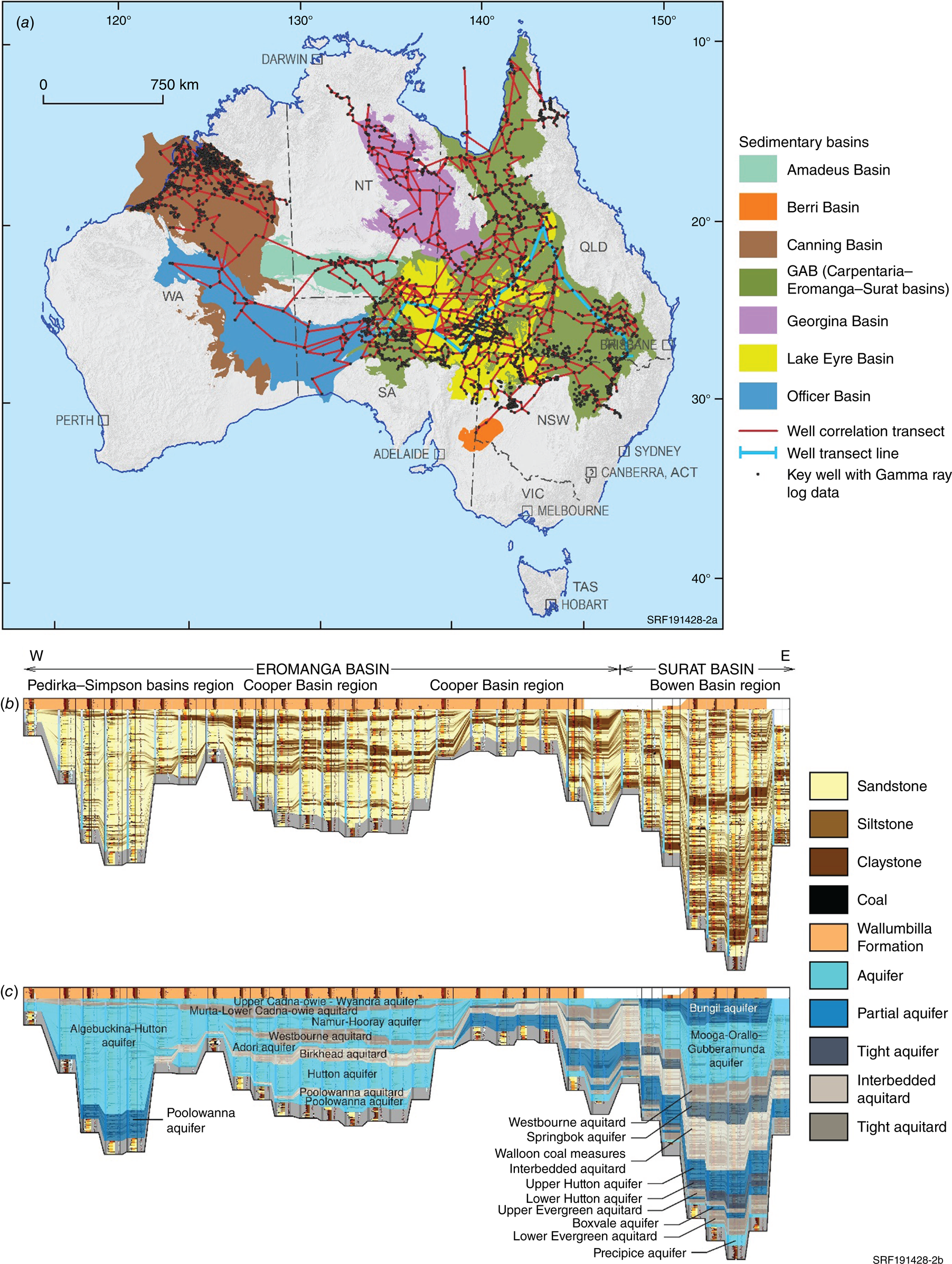
Drillhole correlation transects (Norton and Rollet 2023): (a) location map across Australia, (b) example of cross-section plot from this study across the GAB with lithological variability in aquifers below the Wallumbilla Formation regional aquitard, calculated using the sand/shale ratio and flattened on the Top Cadna–owie–Bungil Formation horizon to show unit correlation and connectivity, and (c) updated hydrostratigraphic classification incorporating variability, with subdivisions based on Surat Basin and Eromanga Basin.
Compilation, collation and integration of data for consistent Australia-wide 3D mapping
Australia’s continental chronostratigraphic framework, developed in collaboration with states and territories, standardises geological and hydrogeological mapping by integrating diverse datasets, including drillholes, airborne electromagnetic (AEM) and seismic data (Fig. 3). This integration produces consistent 3D geological models and stratigraphic surfaces aligned to the Australian Height Datum, enhancing interpretations of basin architecture and resource potential.
Data sources used in this study with relative confidence values assigned between low to high: (a) drillhole formation picks compiled and reviewed for this current study and previously shared by QLD-OGIA and SA-DEW (dark green; high confidence) as well as from State and Territory petroleum wells and studies (light green; medium–high confidence) and water bores (orange; medium confidence); (b) AEM interpretation (low–medium confidence). (c) Seismic interpretation (low–medium confidence); (d) extracts from seismic and modelled surfaces (low confidence).
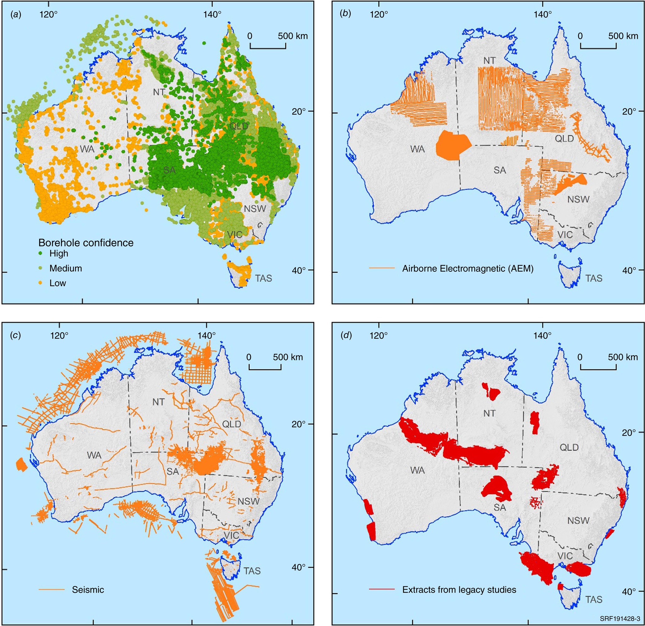
The Australian Borehole Stratigraphic Units Compilation (ABSUC; Vizy and Rollet 2024a) consolidates drillhole data from petroleum, mineral, water and stratigraphic sources. It refines over 1.1 million formation picks from 171,396 drillholes into 1.01 million high-confidence records, standardising stratigraphic units with the Australian Stratigraphic Units Database. ABSUC complements national frameworks and databases, such as the Bureau of Meteorology’s National Aquifer Framework, and Geoscience Australia’s drillhole database (BOREHOLE), improving the understanding of 3D basin architecture, aquifer geometry, and lithological variations.
An initial Australia-wide 3D geological model (Vizy et al. 2025) integrates interpretation of 1900 km of deep seismic reflection data, 130,000 line km of AEM conductivity sections and stratigraphic information from new drillholes undertaken as part of the National Drilling Initiative and review of legacy drillholes. Using a bottom-up approach, the model defines chronostratigraphic packages and aquifer-aquitard boundaries at 1000 m resolution, linking onshore and offshore sedimentary units across eight chronostratigraphic surfaces, from the Paleoproterozoic to the present (Fig. 1): (1) Top Basement (Base Paleoproterozoic), (2) Top Mesoproterozoic (Base Neoproterozoic), (3) Top Neoproterozoic (Base Paleozoic), (4) Top Cambrian (Base Ordovician), (5) Top Silurian (Base Devonian), (6) Top Permian (Base Mesozoic), (7) Top Cretaceous (Base Cenozoic) and (8) Digital Elevation Model (DEM) (Ground surface). These surfaces are used to populate the Geoscience Australia’s EGGS database, supporting resource assessments, groundwater studies and CO2–hydrogen storage targets. Associated thickness maps (isochores) reveal key resource layers distribution and depth across major basins (Vizy et al. 2025).
Key basins, including the GAB, LEB, Pedirka, Galilee, Cooper, Canning, Georgina, Amadeus and Officer basins, are subdivided into additional packages to further delineate hydrostratigraphic groupings. The extended GAB model includes 18 surfaces across eastern Australia, enhancing nationwide sedimentary basin understanding. These models refine groundwater frameworks, identify data gaps and guide future acquisitions to improve confidence, ensuring consistent resource mapping and sustainable resource management.
Applications of 3D models
The integration of 3D geological models into a consistent national framework enables diverse geological and water resource applications. A range of investigations using the data and models are cited in Rollet et al. (2024a), including:
Aquifer studies that inform groundwater management: frameworks, connectivity and bore attribution for groundwater systems in the GAB, LEB and Georgina Basin. Enhanced conceptual models for basin connectivity and groundwater resource strategies, including contributions to the Northern Australia Water Resource Assessment.
CO2 and hydrogen storage: identification of storage potential, including 15 Gt in the western Eromanga Basin.
Energy resource assessments: mapping potential energy opportunities in the western Eromanga and Pedirka basins.
Multi-resource assessments and water management strategies: updated conceptual models for the Eromanga, Cooper, and Galilee basins provide baseline information on groundwater connectivity, supporting multi-resource assessments, water management strategies and contributions to the Northern Australia Water Resource Assessment.
Rare earth element exploration: investigations of rare earth elements in the Toolebuc Formation.
Solid geology updates: improved national geological framework consistency.
These models enhance resource assessments, storage evaluations and groundwater management, supporting Australia’s sustainable development.
Conclusion and recommendations
Geoscience Australia, through the former EFTF program and current Resourcing Australia’s Prosperity Initiative, is advancing the state of subsurface geological knowledge to support sustainable resource development and groundwater system understanding across Australia. By integrating geoscientific data into 3D geological models within a chronostratigraphic framework, consistent interpretations support research, resource planning, infrastructure, and environmental monitoring.
Key priorities include:
Collaboration: strengthening partnerships with states, territories, academia, industry and First Nations communities to ensure accurate, inclusive and cross-jurisdictional geological interpretations.
Multidisciplinary approach: integrating diverse geoscientific data, leveraging from more detailed minerals, energy and groundwater investigations, to improve data coverage and increase confidence and consistency in 3D geological models across state and territory jurisdictions.
Groundwater management: conducting comprehensive assessments of key important groundwater systems where most of the extraction is occurring, like the GAB, Kati Thanda-LEB and Georgina Basin. Refine aquifer boundaries, improve connectivity knowledge and establish baseline data on groundwater quality, spring source aquifers and groundwater-dependent-ecosystems with high-resolution data and monitoring.
Clean energy transition: 3D models are used to map onshore and offshore CO2 and hydrogen storage opportunities for net-zero goals and identify clay-hosted mineral basins for critical mineral exploration supporting clean energy technologies.
Regular updates to 3D models are crucial for resource assessments, environmental sustainability and informed policies.
Data availability
Published with the permission of the CEO, Geoscience Australia. Data and relevant references supporting the results are available in referenced packages included in Vizy et al. (2025).
Declaration of funding
This research was funded by the Australian Government through the Exploring for the Future program and Resourcing Australia’s Prosperity Initiative.
References
Bonnardot MA, Grose L, Wilford J, et al. (2024) Unearthing Australia’s subsurface secrets – an integrated FAIR modelling approach. In ‘Exploring for the Future: Extended Abstracts’. (Ed. K Czarnota). (Geoscience Australia: Canberra) 10.26186/149719
Gradstein FM, Ogg JG, Schmitz MD, Ogg GM (2020) ‘Geological Time Scale 2020.’ (Elsevier) 10.1016/C2020-1-02369-3
Hannaford C, Rollet N (2023) Palynological data review of selected boreholes in the Great Artesian, Lake Eyre basins and Upper Darling Floodplain (part 2) – Infilling data and knowledge gaps. RECORD: 2023/027. 10.26186/147173
Norton CJ, Rollet N (2023) Regional stratigraphic correlation transects across the Great Artesian, Lake Eyre basins and Upper Darling Floodplain region (part 2) – Infilling data and knowledge gaps. RECORD: 2023/028. (Geoscience Australia) 10.26186/147243
Rollet N, Vizy J, Norton CJ, Hannaford C, McPherson A, Tan K, Kilgour P, Ransley T, Wallace L (2022) Geological and hydrogeological architecture of the Great Artesian Basin - A framework to develop hydrogeological conceptualisations. RECORD: 2022/021. (Geoscience Australia) 10.11636/Record.2022.021
Rollet N, Vizy J, Norton C, Hannaford C, McPherson A, Symington N, Evans T, Nation E, Peljo M, Bishop C, Boronkay A, Ahmad Z, Szczepaniak M, Bradshaw B, Wilford J, Wong S, Bonnardot M, Hope J (2024a) Developing a 3D hydrogeological framework for Australia. 10.26186/149418
Rollet N, Hannaford C, Norton C, Kelman A, Bishop C (2024b) Compiling biostratigraphic and borehole stratigraphic correlation data in the Amadeus, Georgina, Officer, South Nicholson and southern McArthur basins. Record 2024/49. (Geoscience Australia) 10.26186/149317
Vizy J, Rollet N (2023) Eastern Australia 3D geological and hydrogeological surfaces update, Version 2.1: Report and data package of updated Great Artesian Basin and Lake Eyre Basin surfaces extending to additional onshore-offshore eastern Australian basins. Record 2023/044. (Geoscience Australia) 10.26186/148552
Vizy J, Rollet N (2024a) Australian Borehole Stratigraphic Units Compilation (ABSUC) 2024 Version 2.0. (Geoscience Australia) 10.26186/149324
Vizy J, Rollet N (2024b) 3D geological model of the Georgina Basin, South Nicholson Basin and Beetaloo Sub-basin– Data package of 3D modelling geological surfaces and isochores, Version 1.0 – Metadata Statement and explanatory notes. Data package. (Geoscience Australia) 10.26186/149290
Vizy J, Rollet N, Nicoll MG (2025) Preliminary 3D chronostratigraphic model of Australia - Data package of 3D modelling chronostratigraphic surfaces and isochores, Version 1.0 – Metadata Statement and explanatory notes. (Geoscience Australia) 10.26186/149923
Nadege Rollet, a Senior Geoscientist at Geoscience Australia with over 20 years of experience and an MSc and PhD from the University of Paris, has worked on petroleum, CO2 storage, seepage and groundwater studies. She now leads the development of a 3D national geological and hydrogeological framework. |
John Vizy, a 3D Geological Modeller and Data Analyst at Geoscience Australia, specialises in GIS mapping, geological modelling, and data integration. Previously at Frogtech Geoscience, he contributed to SEEBASE GIS products. He now develops national models to advance geological and hydrogeological understanding. |
Catherine Norton, a Senior Geoscientist with over 30 years of experience in petroleum, now consults with Geoscience Australia. She holds an MSc in Petroleum Geology and Geophysics from the University of Adelaide. |
Carey Hannaford, a Palynologist at MGPalaeo with over 20 years of experience in the oil, gas and minerals industry, specialises in biostratigraphy, sequence stratigraphy and petroleum exploration. |