

A re-examination of William Hann’s Northern Expedition of 1872 to Cape York Peninsula, Queensland
Peter Illingworth Taylor A and Nicole HuxleyHistorical Records of Australian Science 32(1) 67-82 https://doi.org/10.1071/HR20014
Published: 27 November 2020
Abstract
William Hann’s Northern Expedition set off on 26 June 1872 from Mount Surprise, a pastoral station west of Townsville, to determine the mineral and agricultural potential of Cape York Peninsula. The expedition was plagued by disharmony and there was later strong criticism of the leadership and its failure to provide any meaningful analysis of the findings. The authors (a descendent of Norman Taylor, expedition geologist, and a descendent of Jerry, Indigenous guide and translator) use documentary sources and traditional knowledge to establish the role of Jerry in the expedition. They argue that while Hann acknowledged Jerry’s assistance to the expedition, his role has been downplayed by later commentators.
Keywords: botany, explorers, geology, indigenous history, palaeontology.
Introduction
During the nineteenth century, exploration for minerals, grazing and agricultural lands was widespread in Australia, with expeditions organised through private, public and/or government sponsorship. Poor leadership and conflicting aspirations were common, and the ability of expedition members to cooperate with one another in the face of hardships such as food and water shortages, illness and accidents tested the capabilities of all exploring parties. These factors combined to significantly impede the scientific and economic outcomes of many expeditions. A spectacular example was the 1860–1 Burke and Wills expedition where poor leadership resulted in tragedy and failure. William O’Hara Burke’s (1821–61) fixation with crossing the continent ahead of the numerous scientific, astrological and ethnographic missions planned for the expedition led to his and Wills’ death and a diminished scientific legacy.1 By contrast, Ludwig Leichhardt (1813–48) was committed to scientific endeavour, but was hindered by his single-minded approach, which aggravated expedition members who also harboured anti-Prussian sentiments. As a consequence, the 1844–5 expedition to Port Essington was plagued by conflict and bitterness that clouded the findings.2
The Indigenous contribution to exploration deserves special attention as it has historically largely been ignored or downplayed.3 Since the 1990s, however, more attention has been given to recasting colonial exploration as a collective enterprise involving diverse inputs from party members. Indigenous intermediaries including interpreters, brokers, guides and porters and analysis of Indigenous interactions are now especially being given more research prominence. These reinterpretations of history not only highlight the cultural complexity of exploration, but they also demonstrate the extent to which Indigenous contributions were obscured or deliberately removed from exploration accounts.4
William Hann’s Northern Expedition to Cape York Peninsula was not unique in experiencing conflict and failing to adequately acknowledge the contributions made by party members, notably Jerry, Aboriginal guide and interpreter. This paper will examine several of the incidents that took place during this expedition and the degree to which they may have limited the scientific legacies. To understand these issues, an examination of some of the personalities and contributions of the party members will be made, along with an overview of the expedition outcomes.
Cape York Peninsula—a new frontier
In 1859, Queensland became an independent British colony, no longer administered by New South Wales. Ignoring the presence of Aboriginal people, the new Queensland premier, Robert Herbert (1831–1905), was determined to develop the colony by declaring the ‘empty’ land in the north a valuable resource that should be occupied as quickly as possible. The Unoccupied Land Act of 1860 provided generous terms for British and European squatters to take up opportunities. It was envisaged that wool and mineral exploration would turn the economic prospects of the colony around as it was essentially bankrupt following drought and disastrous government investments.5 By 1861, five key settlement districts had been established: Leichhardt, Mitchell, Darling Downs, Wide Bay, Burnett and Kennedy.6
One of the early English families to settle in the Kennedy district was that of Joseph Hann and his sons William and Frank. In 1862, Joseph went into partnership with Melbourne investors, including the geologist Richard Daintree (1832–78).7 They purchased Maryvale and Bluff Downs pastoral stations, on the western tributaries of the Burdekin River.8 A third nearby property, Lolworth, was acquired later.
Joseph Hann died in a drowning accident in 1864 leaving William and Frank to manage the family properties. With finances tight, the Hann brothers sold Bluff Downs and William shifted to running mainly cattle on Maryvale.9 In 1864, William entered into partnership with Richard Daintree, who had recently arrived in the region from Victoria.10 While Hann pursued more of the pastoral responsibilities, Daintree tended to spend time on his geological interests. They commenced a copper-ore mining-venture at Lynd River, but the cost of transporting ore to the coast was prohibitive and the mine folded.11 Poor seasons and an economic downturn continued to strain the viability of squatters’ holdings, including those of Hann.
The decision to explore Cape York Peninsula
During the late 1860s, modest gold discoveries around Charters Towers, Ravenswood, Etheridge and the Cape, Gilbert and Percy rivers brought prospectors to the region seeking to make their fortunes.12 William Hann’s ability to combine bush skills, a passion for exploration and basic geological knowledge (acquired through his explorations with Richard Daintree),13 provided the incentive for him to join the search for new opportunities in both grazing and mining.14 Daintree expressed his enthusiasm about the mineral potential of Cape York Peninsula and recommended that Hann lead an expedition to explore the inland between Leichhardt’s 1844–5 route and the east coast.15 Late in 1871, Hann himself wrote to W. H. Walsh (1823–88), minister for public works and goldfields, proposing a northern expedition. Hann presented geological specimens and was interviewed by Premier Arthur Palmer (1819–98) and the colonial secretary about the proposal in Brisbane, early in 1872.
The Queensland government approved the proposal for an expedition in February 1872,16 with the aim of: ‘ascertaining, as far north as the 14th parallel of latitude, the character of the country and its mineral resources, with the view to future settlement and occupation.’17 The area to be examined by the expedition included the country about the Kirchner Range travelling north to Princess Charlotte Bay and back south along the coastal fringe to Cardwell.18 Figure 1 is a Cape York Peninsula map belonging to Hann, demonstrating the lack of named features in the inland areas at the time.

|
Hann was instructed to establish a party at his own expense consisting of five men and a government appointed geologist. The expedition was anticipated to take around six months; with the government paying Hann £100 per month providing arms and ammunition, and a salary of £400 plus £100 travelling expenses for a geologist. Hann was also to equip the geologist and provide him with a horse. All collections, maps, specimens and charts were to be the property of the government.19
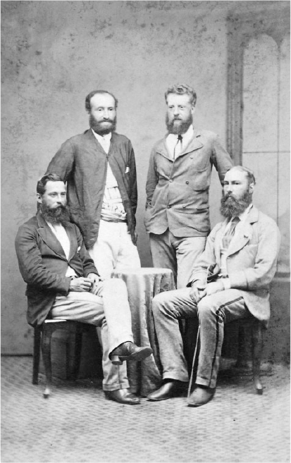
The expedition members (Fig. 2)
|
-
William Hann (1837–89)—expedition leader
-
Jerry (1852–1942)—Indigenous guide and translator20
-
Norman Taylor (1834–94)—geologist21
-
Thomas Tate (1842–1934)—naturalist and botanist
-
Frederick Horatio Warner (1842–1906)—surveyor
-
William Nation (1818–74)—pastoralist and bushman
-
William Robert Stewart—pastoralist and bushman
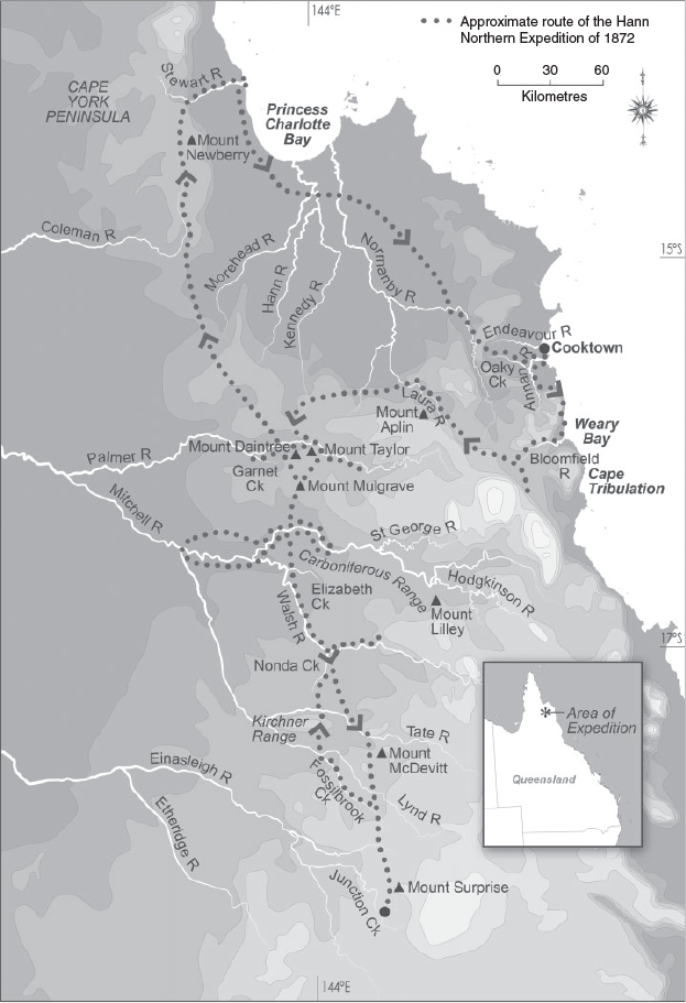
The expedition route
On 26 June 1872, the expeditioners formally commenced their journey with fifteen packhorses, ten spare horses, twenty sheep and five months supplies of flour, tea, sugar, rice, potatoes and dried apples (Fig. 3). It was anticipated that wildlife such as fish and kangaroos would supplement rations as the expedition progressed.22
|
The expedition departed from the most northerly extent of European settlement in Queensland, at Fossilbrook, an outstation of Mount Surprise Station owned by Ezra Firth.23 Following Fossilbrook Creek to its junction with Lynd River, the expeditioners headed north, passing through Kirchner Range whereupon they came to Tate River.24 Again heading north, they arrived at the headwaters of Nonda Creek that was then followed downstream until it fell into Walsh River. Following the 25Walsh, they passed the junctions of Elizabeth and Louisa Creeks. Heading north again they met with Mitchell River where they explored in both directions, downstream as far as the junction with Lynd River. The expedition then headed north again via Mount Mulgrave to Garnet Creek and Palmer River. Here they explored extensively in both directions along the Palmer before heading north-west to reach Coleman River and on to their most northerly point at Stewart River.
26Once on Stewart River, at the fourteenth parallel, they tracked east toward the mangrove coast at Port Stewart. Reaching the ocean, they followed the coast south into Princess Charlotte Bay, where they were met with a confusing array of creeks and rivers stretching over the vast floodplains. They followed Kennedy River in a south-easterly direction until meeting Normanby River that was followed to its headwaters in Normanby Range. It was in the adjoining Cunningham Range that they discovered the first fall of the eastern waterways. There they followed Oaky Creek, a tributary of Annan River. Hann thought this was Endeavour River and followed it to what he believed to be the point where British explorer James Cook had careened his ship Endeavour in 1770. However, they were in fact at the mouth of Annan River in Walker Bay, south of Endeavour River.
Heading south of Walker Bay, the expeditioners ran into difficulties as they approached Bloomfield River. Attempts to push their way through impenetrable mountains and rainforest were extremely difficult, and when inland from Cape Tribulation they were advised by local Indigenous people that the only way south toward their destination of Cardwell was via canoe. Hann was forced to admit defeat and, for the safety of the men and horses, decided on a retreat. To do so required the expeditioners to retrace their tracks north and across the coastal range toward the drier and open forests of the west. Here they followed Laura River (originally named Hearn River by Hann) downstream before sighting landmarks associated with Palmer River. They then followed the Palmer and generally retraced their tracks back to Mount Surprise and on to Junction Creek Telegraph Station, where they telegraphed news of the completion of the expedition on 12 November 1872.27 See Supplementary Material for photographs of areas covered during the expedition.
Personalities, leadership and conflict
The seeds of discontent
Hann planned to commence the expedition on 27 April 1872. He would have been anxious to undertake the journey during the dry season to avoid the perils of high heat and humidity, heavy rain and impassable rivers common to the wet season. Taylor, meanwhile, had received notice of his official appointment to the expedition on 6 April, and left Melbourne two days later. Hann did not receive advice of Taylor’s appointment and travel until 26 April, one day before his planned commencement date. Hann was advised that he was not to proceed without Taylor, and that he was to meet him in Cardwell or Townsville with horses and supplies. There was also a government expectation that Taylor should undertake a short geological survey of the Maryvale to Etheridge regions ahead of the expedition.28 These frustrations were exacerbated when Hann learned that Taylor’s arrival in Queensland had been further delayed through problems with shipping schedules. Taylor finally arrived at Maryvale Station on 18 May, twenty-two days after the intended departure date for the expedition.29
The extent of Hann’s views on the delayed start is best expressed in a thinly veiled swipe in his report:
And here I would beg to call your attention to the fact that the period between the 26th April and the 28th May was time consumed in matters connected with Mr. Taylor, who may be said not to have been in a position to enter on any of the duties of the expedition until the latter date; and I trust that the Government will bear in mind that the delay in the departure of the expedition was not owing to any remissness or want of energy on my part, but solely to the arrangements of the Government in connection with Mr Taylor’s appointment.30
Incidents during the expedition
The first incident to rile Hann occurred three days into the expedition (26 June), when Taylor carelessly dropped a match into dry grass after lighting his pipe. The camp bedding and valuable equipment were narrowly saved.31 Understandably, Hann was annoyed, especially as he had repeatedly warned party members of the fire risks associated with smoking. The incident was certainly significant enough for Hann to include it in his published diary.
The next incident gives further insight into Hann’s temperament. On 30 June, Warner lost Hann’s prismatic compass while making observations. Hann was persistent in his commentary on the matter in his published diary over several days with comments such as: ‘this compass was a serious loss to me, and I felt it such ever after … the loss of my compass troubled me sadly.’32 Various searches were made for the compass, further delaying the party, but it was never recovered.
A more serious incident occurred after some of the party, including Hann, had ventured upstream along the Palmer River for six days and returned to find that Admiral, a good riding horse, had not been hobbled by Taylor back at the base camp and that the horse, together with six sheep, had wandered off. To add to tensions, Taylor joined Tate in complaining that Nation had reduced the amount of flour in the damper, leaving them hungry. Hann, under pressure from this discontent, indicated that rationing would be necessary if the sheep were not found.33 His annoyance increased and he again attacked Taylor on these losses in addition to the loss of his gaiters, the partial burning of his pistol case and warming the only prismatic compass remaining beside an unattended fire. He repeated in both his report and diary that he intended holding Taylor responsible for the lost horse.34
With the loss of the sheep, the general discontent, the prospects of serious rationing and his disappointment at not finding ‘payable gold’ in the Palmer (more on this below), Hann described being down in spirits and unable to rest or sleep.35 He began to question the viability of the expedition and considered terminating it. Hann’s anxieties were allayed somewhat within a day, however. Tasked with searching for the sheep, Jerry and Stewart found them, allowing the expedition to proceed.
While there were a small number of potentially threatening encounters with Indigenous people as the party headed from Palmer River into Princess Charlotte Bay, internal conflicts within the party became less frequent. However, from time to time Hann continued to be bothered by the issue of the rations and the complaints particularly from Tate and Taylor.
He also chose to note in his diary an altercation between Taylor and Tate that led him to revise his opinion of the latter:
Dr Tate is not a person in whom I have the confidence now which I entertained for him once. And, in this matter of confidence, I must mention a trifling circumstance, which is quite sufficient to destroy this feeling in the members of a party in the bush. It has been my usual custom to have some tea made after our arrival in camp, which has generally been early in the afternoon. On this occasion, it was made and partaken of by us all before I started off with Mr Nation, but when I returned, I found that another billyfull had been made, and was quietly being partaken of by those in camp. Now this in itself was a very trifling matter, but entirely contrary to the rules of my camp … .36
This was indeed a trifling matter, although clearly a breach of Hann’s management regime. It is not clear if sharing tea was an established or assumed custom, but it hardly seems worthy of reporting publicly. As the party moved south beyond Bloomfield River the tensions, especially between Hann, Tate and to a lesser extent, Taylor, continued to fester. Hann admitted to responding to some issues angrily and at times regretted doing so. He also had the grace to apologise when he was in the wrong or overbearing.37
The decision to retreat from the coast and abandon efforts to reach Cardwell would have been very hard on Hann given his commitment to achieve his plan as originally conceived. By 12 October, he realised that the rations and the impenetrable rainforest and rivers were his final barriers and his lingering hopes turned to depression.38 However, once a route back across the ranges was determined his mood and tensions seemed to fall away, based on the lack of emotive content in his diaries and report. He finished his report by rising above the personalities and difficulties and suggesting that the journey was ‘comparatively devoid of interest and incident’ and that there was harmony, unanimity and no lingering ill will amongst any of the members. He also admitted to an occasional loss of temper and a few sharp words.39
Hann has been variously described by those who knew him as being petulant, tight fisted, overbearing and not easy to get along with. Geologist and explorer Robert Logan Jack (1845–1921) indicated that Hann confessed to an occasional loss of temper and injustices against his subordinates, all in the heat of the moment.40 These traits were especially tested during the expedition in the interactions with Taylor and Tate. It seems likely that Hann, an accomplished bushman, was highly organised and was irritated immensely by the disorganisation and tardiness of others. By contrast, Hann had a compassionate side when it impacted on the safety of his men. His diary and report seem to reflect a high degree of anxiety regarding the many burdens of the expedition.
Oral histories relating to Jerry’s role
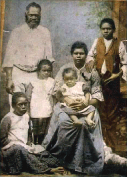
Indigenous people were frequently called upon to help pastoralists, miners and explorers to open up new country throughout Australia by utilising their knowledge of the land and locations for water and tracks through difficult country. Historical records, however, rarely include the Indigenous versions of events. It is only recently that oral histories have begun to emerge from the descendants of Jerry relating to his role in the expedition. While the recording of these histories is ongoing, descendants explain that Jerry was born around 1852, although the exact location of his birth is unknown. He was a Girramay man and became a stockman on William and Joseph Hanns’ properties (The Bluff and Maryvale Stations) when he was a boy of around fourteen years old. The circumstances that led Jerry to Maryvale as a boy have not been ascertained. A view held by some Gudjal people,41 however, was that he had escaped from a massacre and was taken in by the Hann family (Fig. 4).42
|
Gudjal people understand that Jerry knew at least three of the major Indigenous language groups of south-east Cape York Peninsula, including his own Jittabal/Girramay; Gudjula/Gugu Badham; and Wakaman/Yalanji.43 Hann recorded Jerry conversing fluently with the people of the Bloomfield River and Daintree River (Kuku Nyungkul – in an Yalandjic language). In addition to this, Jerry had specific knowledge of pre-contact Indigenous trade and exchange routes linking the southern parts of Cape York Peninsula with Princess Charlotte Bay and areas to the coast.44 Descendants are confident that Jerry guided the expedition along these routes. Their oral history also suggests that in most encounters with Indigenous groups during the journey, Jerry was able to communicate in local languages, no doubt helping to allay fears on both sides and avoid potential conflicts.
There are also numerous references throughout Hann’s report and diary to Jerry’s skills across a range of areas. He was constantly called upon to track missing horses and stock and to help guide the party. Jerry also introduced the expedition members to bush foods and to ‘sugar bag’, a native honey. This was always a delicacy and required some skill to locate. Jerry was adept also in catching or shooting wildlife that would have helped to supplement rations.45
Historian Galiina Ellwood has helped document Girramay oral history relating to Jerry’s contributions to mining and exploration beyond the Hann expedition. Examples include Jerry’s role in supporting Richard Daintree in 1865 to locate a goldfield near Cape River. In 1873, Jerry also supported A. C. Macmillan (1840–1905) who was commissioned to survey a road from Cooktown to the Palmer goldfield. During this survey, Jerry became involved in helping avert a serious attack from local Indigenous groups near Cooktown at a location now known as Battlecamp.46 In recognition for this and his services to exploration, mining and to the Hann family, Jerry was presented with a brass breastplate. It had the inscription ‘King Jerry of Kobubla’ (meaning, ‘King of the Burdekin River’). Later in his life Jerry was reported to have been living with family at Corinda, a settlement in Charters Towers. He and his wife Topsy Hann (no relation to William Hann) had six children (Kullanigh, Wyhna, Harry, Hilda, Zoe and Sadie). While Topsy was buried at Corinda, the location of Jerry’s death (in 1942) and grave are yet to be ascertained.47
The fallout after the expedition
The official published records of the expedition include Hann’s report and diary and Taylor’s geological report.48 Taylor’s report originally included a diary that referenced his specimens and a map with a coloured geological overlay.49 Taylor’s diary along with his personal journal of the expedition have never been located. Recently, however, a copy of the map has been found.50 Unpublished items that have survived include Hann’s original diaries and notebooks (transcribed by Harry Clarke, a Hann descendant),51 and Tate’s diary from the expedition (transcribed by Margaret Ross).52
When Hann’s diary and report were published, they had the unfortunate effect of generating criticism rather than praise or public debate about the expedition’s findings. The media focused on Hann’s management and treatment of expedition members and the minor incidents encountered. One paper suggested that Hann did not discover anything apart from a climbing kangaroo that he heard about but did not see (the writer blaming the kangaroo for this problem). The author went on to say, sarcastically:
The journey of Hann will be remembered when Leichhardt’s is forgotten,—if not till then; and Hann will be looked back up by our descendants as the great pioneer of the ‘never never’. Why the service he has rendered us in his many disquisitions on camp management would be alone sufficient to ensure this. Hann’s report is especially valuable in this respect, and his want of irritation of trifles belongs to the true explorer.53
Others were quick to criticise Hann for his general mismanagement and being somewhat repressive in rationing supplies.54 Of greater concern were criticisms regarding Hann’s tendency to publicly question Taylor’s geological opinions, prompting suggestions that Hann’s claims as an explorer were small and only bolstered through an association with Richard Daintree.55
Taylor, in his published report, was critical of Hann taking possession of his mineral and fossil collection in Brisbane, where it was re-packed causing further damage, in addition to what had already occurred during the expedition. Hann then sent the fossils to Sydney with a letter claiming that they had been collected by himself. Taylor states in his report:
I myself had collected fully one half, the rest being obtained by the other members of the party, and as Geologist to the Expedition, I consider that all the fossils were mine, fully as much as that the botanical specimens collected by myself and others belonged to Dr Tate as Botanist.56
A writer under the pseudonym ‘Palam Qui Meruit Ferat’57 was scathing about Hann’s lack of acknowledgement of Taylor’s contributions and the attribution of specimen collections to himself. The author claims to have seen Taylor’s journal, sketches, descriptions of new fossil shells, bones and other specimens before Hann had reached Brisbane, and also suggested that the map produced by Warner was compiled from Taylor’s observations.58
While any leader would claim discoveries from an expedition as being ‘theirs’, it would also normally be assumed they were referring to the discoveries in the name of the expedition. The claim of being ‘the collector’ of specimens is a different matter and one that drew the attention of several commentators on the Hann expedition. Privately, Taylor felt his professional reputation and dignity to be at stake. Insights into his feelings are reflected in personal letters to his professional mentor and friend Reverend William Branwhite Clarke (1798–1878). In a fairly intemperate manner, he described to Clarke how Hann, far from being a gentleman, was no more than an uneducated bullock driver with a smattering of geology from Daintree and that he did not know what a mica schist or gneiss were. He also claimed that all Hann’s remarks in his published diary on geology were obtained from Taylor, but that he had varied the information and:
turned it upside down in a manner. This ignoramus contradicted me on all occasions & the result was endless quarrelling. I could not stand his impertinence, especially coming from a man who cannot write & barely read. Hence the bitterness shows in his Report which, bye the bye, was written by Nation—a man who acted as Hann’s private secretary & toady59 & made himself obnoxious to all the party.60
Taylor’s suggestion that Hann could not write was an exaggeration. However, it is probable that Hann may not have had a lot of experience, or confidence, in writing major reports to government. Based on the transcriptions of Hann’s notebooks and diaries by Clarke, it is correct that Nation had a role in Hann’s diaries and could have drafted the published report and diary.61 Nation’s contribution to field diaries is specifically mentioned in Hann’s first notebook where on 25 August he refers to Nation writing up his diary.62
Taylor also resented Hann challenging his geological opinion; for example, when the party surveyed the country immediately to the south and west of Kirchner Range. Here Taylor expressed an opinion that the country was not gold-bearing. Hann expressed a different view in his published diary and report, suggesting that the region was, in his strong opinion, very worthy of the attention of gold diggers.63 On the return trip, as the party traversed country stretching from the Palmer River to the east of the Kirchner Range region, Taylor reported finding auriferous reefs worthy of further prospecting. He maintained his original perspective, however, that Kirchner Range, to the south and west did not show any potential. On this issue, Hann chose to antagonise Taylor in his report by saying:
And, I would beg to mention here, that Mr Taylor now gives it as his opinion that gold might possibly be found all across the country, from the Kirchner Range to the Palmer, nearly the whole of which is of mica schist formation, whereas, before this discovery, he maintained that this formation would not yield gold. I leave him to reconcile these statements, and his change of opinion.64
Taylor reacted in his report by defending his original opinion of these two distinct regions and their potential. In correcting Hann, he suggested that ‘with all deference to Hann’s higher qualifications’ the judgements being made by Hann were based on information provided to him by Taylor.65 It seems unfortunate that these grievances were aired publicly in both Taylor’s and Hann’s reports.
A particular disappointment for Taylor’s professional integrity was the loss of his diary. In a private letter to Clarke, Taylor expresses his despair about this:
Staiger tells me that my diary of the Expedition has been lost—another sample of their treatment. As it contains the references to all the rocks etc brought down with Numbers corresponding with those on the specimens, of course the specimens are now valueless, unless I were to go over my original journal & send them particulars, which I certainly don’t feel inclined to do. I am heartily sick of the name of the Expedition & all to do with it.66
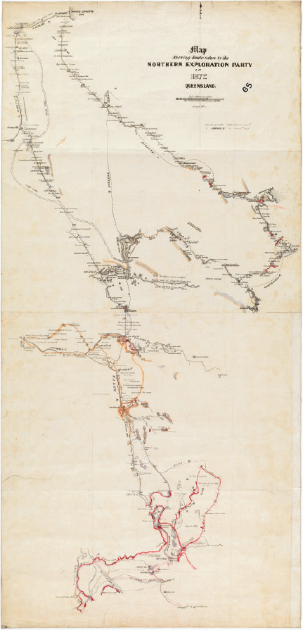
When this letter was written in February 1874 it was clear that Taylor had all but wiped his hands of the expedition. The only copy of Taylor’s published report languished uncatalogued in a Queensland department until it was located in 2018, without the diary and accompanying map. The coloured map prepared by Taylor of the geology of the expedition was found in 2019, also uncatalogued, at the State Library of Victoria (Fig. 5).67
|
Taylor’s diary was central to describing his collection and it also contained sketches and diagrams that may well have contributed to a more significant geological legacy. Historian Ann Moyal suggests that Taylor was not alone, with others having geological and other scientific research and collections poorly handled through the indifference of colonial bureaucrats.68
The legacies
Despite Hann’s report and diary downplaying the findings of the expedition and inadvertently generating criticism, outcomes can nevertheless be identified. The following provides an overview of some of these findings.
Geographical
An important feature of the expedition was a better understanding of the landforms and river systems, where they fell and what creeks and rivers they joined with. These discoveries were important for the future development and mapping of Cape York Peninsula. Some of the geographical highlights included:
The naming of: Tate River; Walsh River; Nonda Creek; Elizabeth Creek; Garnett Creek; Palmer River; Coleman River; Stewart River; Normanby River; Oaky Creek; and Hearn River.
Relationship of flows of the Tate and where it falls into Lynd River; and the relationship of the Walsh and Lynd Rivers to Mitchell River.
The naming of Taylor’s Carboniferous Range; Mt Mulgrave; Mt Daintree; Mt Taylor; Jessie’s Tableland; Mt Newberry; and Mt McDevitt.69
70The descriptions, reports and map that were produced represented the most comprehensive information of the region available at that time. The mere hint of minerals and descriptions of reasonable grazing country were a catalyst for the rapid European occupation of large parts of north Queensland.71
Geological and palaeontological
Geological
The most significant economic outcome to emerge from the expedition was the discovery of gold at Palmer River. Although Taylor was optimistic about the potential economic value of what they found, Hann was more guarded and considered the prospects to be, at best, ‘flattering’. James Venture Mulligan’s subsequent expedition to Palmer River in 1873 (often credited with discovering gold in the region), kicked off what was to become one of the greatest gold rushes seen in Australia, with nearly 20,000 people working and living in the region by 1877. Mining in the Palmer region preceded pastoralism with Cooktown being established in 1873 primarily to serve the miners. It became one of the busiest ports in Queensland, serving mining and associated industries. By 1875, Maytown, on Palmer River, had grown significantly and become the administrative centre for much of the Peninsula, with a few smaller settlements emerging in the area. It began declining as gold dwindled from the 1890s.72
The total yield of gold produced from the Palmer from 1874 to 1980 is estimated to be 30,709 kg of alluvial gold and 4,340 kg of lode gold, with the peak productive periods occurring between 1874 and 1882. Historians Denaro and Ewers argue that these estimates are probably conservative.73
Beyond commentary on gold and other minerals, Taylor made other geological observations that contributed importantly to the better understanding of geological structures making up the Australian landscape. One observation was finding fossil specimens of Glossopteris (fossilised leaves broadly from the Permian through to the early Triassic periods) in the sandstone and shale tablelands between Mitchell and Walsh Rivers. Richard Daintree, in his geological map of Australia, considered that much of Australia and especially the inland was dominated by Desert Sandstone, which at the time was thought to have largely arisen from the Cainozoic (2.6–66 million years). For some time, Daintree’s position of a relatively uniformly formed Desert Sandstone complex held strong in the science community. However, the Glossopteris Taylor found in Desert Sandstone belonging to an earlier geological period confounded this widely held belief. To further complicate matters he also found fossils of Hinnites (a species of scallop) and Ostrea (oyster genus) in Battle Camp Range (near Cooktown) in what he believed to be the same sandstone strata as he found the Glossopteris near Mitchell River. Both these marine molluscs come from the Cretaceous. Geologist David Branagan discusses this dilemma with suggestions that others, like Etheridge and Jack, believed the two sandstone entities were probably not connected (as Taylor had speculated), and that the anomalies might be explained by denuded fossil fragments finding their way through disturbed strata systems. The stratigraphic/palaeontological problems were eventually resolved following further mapping that demonstrated that many sandstones while similar in appearance are in fact quite different in age. Weathering accounts for the bulk of the processes helping to give a sense of uniformity. Further studies have also demonstrated that sedimentation occurred during both the Mesozoic and Cainozoic and that Glossopteris in fact existed both in a temporal and lateral range across the Palaeozoic and early Mesozoic (becoming extinct by the end of the Triassic Period).74
The fact that Taylor found both marine and leaf fossils in similar black shale was initially treated with some scepticism. His discoveries became one of the pieces of evidence that helped to establish our current understanding of the complexity and age of Desert Sandstones in Australia.
Palaeontological
While Taylor was not the first to describe examples of the Early Cretaceous in Queensland, he was the first geologist to provide a comprehensive collection of fossils (as part of the expedition) in the richly fossiliferous Walsh River region north of Chillagoe (Wrotham Park). The region is now known as one of the best exposed marine sequences in Australia dating back to the Early Cretaceous. It was Etheridge (Jnr) who some years later provided a taxonomic analysis and description of this collection.75 The area contains key index taxa that document a significant flooding event during the early Cretaceous during which a third of the continent was inundated.76 The initial vertebrate and invertebrate fossils collected by Taylor and the expedition members were important because they represent one of the most diverse and abundant marine faunas from the late Aptian preserved in Australia.77
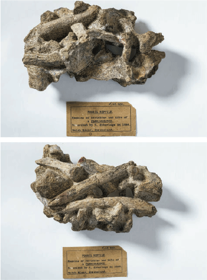
The party found numerous genera of marine Cephalopod fossils including Peratobelus, and several Ammonites (Aconeceras Toxoceratoides and Tropaeum) (Fig. 6); various bivalve and scaphopod molluscs; crustacean specimens (including at least one specimen later described as Callianassa, then Enoploclytia) and fossil wood with Teredo boring (made by the mollusc Serpula—‘shipworm’).78 Warner found what Taylor initially described as some fine plesiosaur vertebrae (Fig. 7) but were later described by Jack and Etheridge as being Ichthyosaur vertebrae.79 This specimen was one of many that suffered damage or loss and its whereabouts is not certain. Palaeontologist Stephen Poropat is increasingly confident that the specimen was in fact a plesiosaur and is probably currently located at the Queensland Museum.80

|
|
In summary, the Northern Expedition of 1872 was important in providing pertinent geographical and geological information across a vast area of north Queensland that was otherwise a ‘blank canvas’ in Western geography before the expedition. More specifically, however, the geological findings were not spectacular other than the gold found in Palmer River. The palaeontological significance was valuable along with the anomaly associated with the fossilised leaves and molluscs found in sandstones. Taylor himself conceded that he:81
found no other minerals of economic value … . An exploring party, however, might pass within a few yards, or even over, valuable lodes and never see them; and my time, whilst travelling, was entirely occupied in taking the courses and roughly mapping the country.82
And as Taylor indicates, further important economic finds did emerge across numerous areas of the Peninsula (beyond just Palmer River goldfields).83 One of the more prosperous emerged around the Tate and Walsh Rivers. Commercial quantities of gold, tin, tungsten, molybdenum, lead and silver, copper, coal, antimony and fluorspar were all found and mined into the twentieth century.84
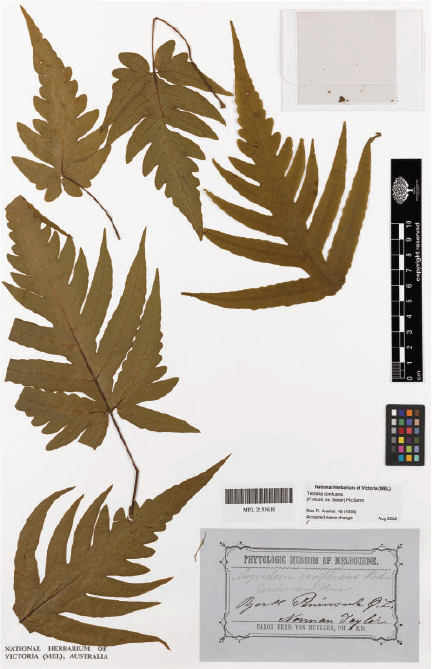
Botanical
A comprehensive examination of the botanical collections of the Hann Expedition was recently undertaken by Dowe and Taylor (2019).85 Thomas Tate was the designated naturalist for the expedition and thus had responsibility for both flora and fauna collections. A total of 81 botanical specimens have been located that were collected by Tate (Figs 8, 9). Taylor, on the other hand, already had considerable experience with collecting botanical specimens while undertaking geological surveys. Apart from Taylor’s assigned geological responsibilities for the expedition, he also un-officially undertook to collect botanical specimens for Baron Ferdinand von Mueller (1825–96), government botanist of Victoria. A further 68 specimens collected by Taylor have been located, totalling 149 surviving specimens from the expedition.86 Five new taxa were named after members of the expedition (Table 1).

|
|

|
Dowe and Taylor sum up the botanical significance of the expedition with:
Overall, the botanical results of the expedition were meagre considering the potential to encounter and collect new species in the habitats travelled through, such as the diverse and species-rich rainforest areas between the Annan and Bloomfield rivers. … Tate’s engagement with the flora of these habitats was minimal whereas Taylor made a collection of ferns that proved of considerable interest to botanists.87
Fauna
Possibly the most significant faunal legacy from the expedition was the sighting of the tree kangaroo (Dendrolagus lumholtzi; Indigenous 88name:89 Boongary). Hann makes a very brief mention of the discovery in his diary and notebook of the tree kangaroo and Jerry’s familiarity with it.90 It is only in his officially published diary that he becomes more expansive about the sighting, by stating:
And here I may as well mention that Jerry told me about an animal found in these scrubs, as related to him by the Cardwell blacks [as written]. He says that it is a kangaroo or something like it, and climbs trees, and he was fortunate enough to see one on a day when we were camped among scrubs … . I have never found my black boy [as written] to err in his statements or reports; and moreover, he spoke to me about this animal many months previous when going over land to Melbourne with sheep … . And here is a chance for some enthusiastic naturalist to distinguish himself and enrol his name on the list of Fame, by adding another object to the natural history of the world.91
It seems extraordinary that despite the confidence Hann had in Jerry, and the conviction that the tree kangaroo existed, he did not attempt to lay claim to the discovery.92 Instead, as Covacevich suggests, Tate is credited as first finding the bones of the tree kangaroo and thus the first European to describe its existence.93
It was the Norwegian theologian/ethnographer Carl Sofus Lumholtz (1851–1922) who finally collected specimens of the tree kangaroo and is commemorated through its name Dendrolagus lumholtzi. As with previous European ‘discoverers’, Lumholtz made this discovery while living and working with the Indigenous inhabitants of the Herbert-Burdekin region of North Queensland.94
Other than Jerry’s sighting of the tree kangaroo, it appears that little effort or perhaps interest was given to scientific collecting of fauna. The pace of the expedition would have created a further disincentive for the time absorbing and bulky work of fauna collecting.
Agricultural and pastoral
Despite Hann providing a slightly gloomy perspective, large areas of good pastoral country were identified throughout parts of the inland of the Peninsula. Following the release of Hann’s report, many of these pastoral areas were steadily occupied.95 While he considered the Princess Charlotte Bay Region very poor, he did find areas south along the coast to be valuable for sugarcane.96
The Palmer River Gold Rush and the reports of reasonable pastoral areas were enough to attract graziers, some probably wishing at least to supply growing local markets in Maytown and Cooktown. Hann personally benefited from this opportunity by droving cattle for a time to help supply local markets in Maytown. By 1880, many cattle runs had emerged across North Queensland. Despite being considered good pastoral land, it was still marginal and subject to flooding during wet seasons and drying out and often becoming valueless in the dry seasons.97 The agricultural and grazing development that followed Hann’s 1872 report seemed to be more related to opportunism and rapid expansion of mining and growing settlements rather than any considered planning.
Indigenous engagement
The colonial frontier rapidly moved north into Cape York Peninsula once payable gold was found in Palmer River. With the influx of more than 20,000 people into the region from 1873, and the growth of settlements such as Maytown and Cooktown, came conflicts between the Indigenous people and settlers. Ellwood claims that the Palmer region acquired a reputation for fierce Indigenous resistance.98
While Ellwood outlines a legacy of Indigenous engagement in the mining and service industries in the region,99 the expansion of the pastoral industry saw significant negative impacts on Indigenous inhabitants. Much of their prime land was trampled by stock, native animal food sources scattered, and watering places taken and or fouled. Allingham describes the sophisticated guerrilla war tactics employed by Indigenous groups against squatters, travellers and shepherds.100 As attacks increased so did retribution through the efforts of superior weapons and the notorious native police. Massacres of Indigenous people were also commonplace, especially in the first ten years of settlement of the Peninsula region. Allingham claims that 10–15% of the European population lost their lives from conflict with Indigenous people, whilst the number of Indigenous people killed is assumed to be considerably greater.101
As discussed earlier from an examination of incidents and route decisions from the Hann report and diaries, it is clear that Jerry played a more significant role in the survival of the expedition than is commonly understood.102 Jerry’s specialist knowledge and language skills would have certainly helped to minimise conflict.103 In the concluding remarks of his published diary, Hann says:
they all [members of the expedition] deserved due credit, and my best thanks for that, I would especially refer to the native boy, Jerry, who unsustained by the same inducements, was faithful and obedient in every difficulty, and staunch in every danger.104
Hann provided a few brief ethnographical observations in his diary, such as mud smearing as safeguard from flies, and an account of the construction of huts and sleeping structures.105 However, it appears that Taylor wrote much more detailed ethnographical accounts in his now lost journal of the expedition. Geologist Robert Brough Smyth in his 1878 publication, Aborigines of Victoria, with Notes Relating to the Habits of Natives of Other Parts of Australia and Tasmania quotes Taylor discussing the customs of Indigenous peoples of Cape York Peninsula:
Their cooking is done by scooping a hole in the sand in the riverbeds, making a fire, and piling stones on. When sufficiently heated, the wood is taken away, the stones arranged flat, the animal to be cooked is laid on them, and then covered with some green branches, over which is laid tea-tree bark, and the whole covered with sand. … On the inland rivers, or those flowing into the Gulf of Carpentaria, the natives’ food appeared to be principally mussels and fish … . On the coast, at certain seasons, turtle are a favourite food, and other seasons bivalves (Ostrea, Perna, and Cyrena) and univalves (Cerithium and Potamides) are obtained in great quantities … . The inland tribes obtain Kangaroos and opossums, &c., but these are rare on the coast. The coast scrubs contain great varieties of nuts and fruits; and generally, the seeds of two water-lilies (Nelumbium and Nymphaea), the root of an aram, the nuts of a zamia or cycas, various yams and roots of different creepers, form their food. Several of the roots and nuts are poisonous, and require a long and tedious preparation, by maceration in water and filtering through the sand, the results being a tasteless starch.106
Smyth also quotes Taylor in the same volume, giving detailed comparisons of Indigenous customs south of the seventeenth parallel in relation to fires, camp set-up and lean-to structures. He also quoted Taylor’s description of cave paintings near Kirchner Range that he compares with those he had seen in the Bondi area of Sydney. This latter point was not recorded by Hann.107
Conclusion
Several key factors challenged the Hann expedition, generating serious public criticism. The focus on disunity and annoying frustrations in Hann’s published report and diary led to condemnation of Hann’s leadership and management style. The personalities and disharmony that underpinned the expedition can, in part, be attributed to Hann’s fiery temperament and the class differences between Taylor, Tate, Nation and Hann. The nineteenth century was an era when English class distinctions significantly influenced relationships.
Hann was also criticised for laying claim to geological and fossil specimens, for publicly challenging Taylor on his professional opinions, and for the mishandling of Taylor’s specimens at the end of the expedition. In his published report and diary, Hann downplayed any significant expedition findings and these factors all combined to contribute to a limited analysis of the remaining specimens.
This paper provides a detailed examination of some of the outcomes of the expedition. However, a greater appreciation of the geological outcomes would be possible if Taylor’s missing diary and personal journal were found. The paper has also provided elements of Indigenous oral history from descendants of Jerry, one of the expedition members. Pursuing these knowledge systems is only now being recognised as central to understanding Australia’s unique natural and cultural environment.
Conflicts of interest
The authors declare no conflicts of interest.
Acknowledgements
Members of the extended family of Nicole Huxley are especially thanked for their generosity and the sharing of oral histories. The authors wish to acknowledge and thank the following people: Dr John Dowe, James Cook University for his support and editorial advice; Dr Tom Darragh, the Melbourne Museum for his long standing encouragement and input into documenting the work of Norman Taylor; Robert Bulltitude, the Queensland Department of Natural Resources, Mining and Energy; Dr Steve Poropat, palaeontologist; Dr Warwick Wilmot; Dr Ian Withnall; and Dr William Kitson, Queensland geologists for their advice; Kristen Spring, Queensland Museum for the supply of fossil images; Margot Nimmo, great granddaughter of William Hann for information on William Hann; Jim McJannett, Cooktown Historic Society for his supply of material; Pina Milne, Angharad Johnson and Cathy Trinca, Royal Botanic Gardens Victoria for their imaging and supply of Taylor’s botanical specimens; Olga Tsaras and Kylie Best, State Library of Victoria for their support and for locating Taylor’s missing coloured map; Cecelia Carroll, Queensland Department Environment and Science Library for finding the uncatalogued report of Norman Taylor; Bronwyn McBurnie and Louise Cottral, JCU’s Special Collections Library for their support; Claire Burton, Cairns Regional Council for preparing the map; and Lorraine Lawrence and Michael Lawrence Taylor for editorial support and supply of images. This research did not receive any specific funding.
References
Allingham, A. (1975) ‘Pioneer squatting in the Kennedy District’, ch. 7 in Lectures on North Queensland History, second series, ed. B. J. Dalton, Townsville, pp. 77–96.Anonymous (1872a) Maryborough Chronicle (Queensland), 30 July, 4.
Anonymous (1872b) Northern Argus (Queensland), 21 December, 3.
Anonymous (1873) Queensland Times (Ipswich), 27 March, 4.
Anonymous – Asmodeus (1873) Rockhampton Bulletin (Queensland), 22 March, 2.
Anonymous – Palam Qui Meruit Ferat (1873) Brisbane Courier, 24 February, 2.
Bishop, C. and White, R. (2015) ‘Explorer memory and Aboriginal celebrity’, in S. Konishi, M. Nugent and T. Shellam (eds) Indigenous Intermediaries: New Perspectives on Exploration Archives, Canberra, pp. 31–66.
Bolton, G. C. (1970) A Thousand Miles Away: a History of North Queensland to 1920, Canberra.
Bolton, G. C. (1972) ‘Daintree, Richard (1832–78)’, Australian Dictionary of Biography, National Centre of Biography, Australian National University, http://adb.anu.edu.au/biography/daintree-richard-3350/text5043, published first in hard copy 1972, viewed 31 August 2020.
Branagan, D. (2004) The Desert Sandstone of Australia a late nineteenth-century enigma of deposition, fossils, and weathering, Earth Sciences History, 23, 208–256.
| The Desert Sandstone of Australia a late nineteenth-century enigma of deposition, fossils, and weatheringCrossref | GoogleScholarGoogle Scholar |
Clark, I. and Cahir, F. (eds) (2016) The Aboriginal Story of Burke and Wills: Forgotten Narratives, Melbourne.
Clarke, H. (1982) Expedition of Exploration to the Endeavour River, Cape York Peninsula, 1872 / William Hann; Reconstructed from His Diary and Two Notebooks, H Clarke: H/35, James Cook University, Special Collections.
Covacevich, J. (2002) First formal Australian record of a tree kangaroo: Aboriginal, not European, Historical Journal , 26, 220–223.
Darragh, T. A. (1977) The first geological maps of the continent of Australia, Journal of the Geological Society of Australia, 24, 279–305.
| The first geological maps of the continent of AustraliaCrossref | GoogleScholarGoogle Scholar |
de Keyser, F., and Lucas, K. G. (1968) Geology of the Hodgkinson and Laura Basins North Queensland, Department of National Development Bureau of Mineral Resources, Geology and Geophysics Bulletin, 84, 1–279.
Denaro, T. J. and Ewers, G. R. (1995) ‘Mineral Assessment of Cape York Peninsula, Cape York Land Use Strategy’, Department of Minerals and Energy Queensland and Australian Geological Survey Organisation, pp. 1–243.
Dowe, J. L., and Taylor, P. I. (2019) The botanical collections of William Hann’s Northern Expedition of 1872 to Cape York Peninsula, Austrobaileya, 10, 506–538.
Ellwood, G. (2014) Aboriginal prospectors and miners of tropical Queensland, from pre-contact times to ca.1950, Journal of Australasian Mining History, 12, 59–80.
Ellwood, G. (2018) The Aboriginal miners and prospectors of Cape York Peninsula 1870 to ca.1950s, Journal of Australasian Mining History, 16, 75–92.
Gibbney, H. J. (1974) ‘Lumholtz, Carl Sophus (1851–1922)’, Australian Dictionary of Biography, National Centre of Biography, Australian National University, http://adb.anu.edu.au/biography/lumholtz-carl-sophus-4047/text6438 viewed 3 October 2020.
Hann, W. (1873a) Copy of the Diary of the Northern Expedition under the Leadership of Mr. William Hann, Brisbane.
Hann, W. (1873b) Report from Mr. W. Hann, Leader of the Northern Expedition Party, Brisbane.
Jack, R. L. (1921) Northmost Australia: Three Centuries of Exploration, Discovery, and Adventure in and around the Cape York Peninsula, Queensland, vol. 2, London.
Jack, R. L. and Etheridge (Junior), R. (1892) The Geology and Palaeontology of Queensland and New Guinea, Brisbane.
Joyce, B. and McCann, D. (2010) ‘Conflicting priorities: exploration, science, politics and personal ambition’, in Burke and Wills: the Scientific Legacy of the Victorian Exploring Expedition, eds D. McCann and B. Joyce, Melbourne, pp. 1–343.
Konishi, S., Nugent, M. and Shellam, T. (eds) (2015) Indigenous Intermediaries, New Perspectives on Exploration Archives, Canberra.
Lack, C. L. (1962) History and potential future of Cape York Peninsula, Journal of the Royal Historical Society of Queensland, 6, 942–1013.
Monroe, M. H. (2020) ‘Fossil Site Walsh River and Elizabeth Creek’, in Australia: the Land Where Time Began—a Biography of the Australian continent, Melbourne. https://austhrutime.com/fossil_site_walsh_Eiver_elizabeth_creek.htm viewed May 2020.
Moyal, A. (2003) Letters from Norman Taylor to Rev. W. B. Clarke, in The Scientific Correspondence of the Rev. W. B. Clarke, Australia’s Pioneer Geologist, vol. 2, Melbourne, pp. 1–1299.
Nicholls, A. (2012), ‘The young Leichhardt’s diaries in the context of his Australian cultural legacy’, in The Leichhardt papers, reflections on his life and legacy, edited by R. J. Fensham, Memoirs of the Queensland Museum, 7(2), 541–652.
Olsen, P. and Russell, L. (2019), Australia’s First Naturalists, Indigenous Contributions to Early Zoology, Canberra.
Poropat, S. F. (2020) ‘Walsh River Fauna’, unpublished literature review, personal communication.
Rimmer, M. R. (2004) Up the Palmerston, a history of the Cairns hinterland up to 1920, Glovers Printing Works Bundaberg Queensland, 1, 1–225.
Ross, M. (2003) The Hann expedition to explore Cape York Peninsula 1872, Journal of the Royal Historical Society of Queensland, 18, 273–286.
Smyth, R. B. (1874) Geological Survey of Victoria, 1874, Report of Progress, 1, 20.
Smyth, R. B. (1878) Aborigines of Australia, with Notes Relating to the habits of natives of other part of Australia and Tasmania, vol. 1, Melbourne.
Tate, T. (1872) ‘Diary 26 June – 10 November 1872 of Thomas Tate, botanist with the government expedition under the leadership of William Hann which explored the North Queensland hinterland in 1872’, transcribed by Margaret Ross, Mitchel Library, Sydney.
Taylor, N. (1873) Mr. N. Taylor’s Report as Geologist to Mr. Wm. Hann’s Expedition, Brisbane.
1 Joyce and McCann (2010) pp. 19–21.
2 Nicholls (2012) pp. 541–553.
3 Bishop and White (2015) p. 31.
4 Konishi and others (2015) pp. 1–6, including other publications providing new insights regarding Indigenous contributions to exploration, such as, Olsen and Russell (2019) and Clark and Cahir (2016).
5 Allingham (1975) explains that a depression occurred in the region largely as a consequence of the collapse of two English Banks that had underwritten the Queensland Government’s excessive borrowing, p. 88.
6 Allingham (1975) Kennedy was declared a district of settlement in Queensland in 1861 and broadly stretched from midway between Maryborough and Rockhampton to just south of Cairns. Settlement stretched a couple of hundred kilometres inland in the north of the region, pp. 78–80.
7 Bolton (1970) p. 33.
8 Bolton (1970) p. 33.
9 Bolton (1970) pp. 39–45.
10 Allingham (1975) pp. 87–88.
11 Rimmer (2004) pp. 129–130.
12 Ross (2003) p. 273.
13 Richard Daintree was a well-recognised geologist who had come to Queensland from his role with the Geological Survey of Victoria. Bolton (1972).
14 Jack (1921) p. 375.
15 Ross (2003) p. 274.
16 Ross (2003) p. 274. Clarke (1982) pp. 2–3.
17 Hann (1873b) p. 1.
18 Anonymous (1872a).
19 Ross (2003) pp. 274–277.
20 Great-great-grandfather of the second author of this paper.
21 Great-grandfather of the first author of this paper.
22 Ross (2003) pp. 275–277.
23 Lack (1962) p. 965.
24 A number of geographic features, such as hills, ranges and rivers named by the expedition are listed later in the paper.
25 Hann Family Archive, H/21, The Province of Queensland by James Wyld, Geographer to the Queen, Charing Cross East, 457 Strand and 2 Royal Exchange, London. Published by James Wyld, 1865. Map. Scale 40 British miles to 1 inch. Typescript.
26 Norman Taylor Collection, MS 16289, Australian Manuscripts Collection, State Library of Victoria.
27 Dowe and Taylor (2019) p. 507. Jack (1921) pp. 374–409.
28 Hann (1873b) p. 1. Taylor (1873) p. 1.
29 Hann (1873b) p. 1.
30 Hann (1873b) p. 1.
31 Hann (1873a) p. 1.
32 Hann (1873a) p. 2.
33 Clarke (1982) pp. 28–29.
34 Hann (1873a) p. 7. Hann (1873b) p. 6.
35 Clarke (1982) p. 29.
36 Hann (1873a) p. 18–19.
37 Hann (1873a) p. 19.
38 Hann (1873b) p. 11.
39 Hann (1873b) p. 24–26.
40 Jack (1921) p. 376.
41 While Jerry was a Girramay man, he spent much of his life in Gudjal country.
42 Gudjal/Girramay oral history.
43 Gudjal/Girramay oral history.
44 Gudjal/Girramay oral history. Ellwood (2014) pp. 63–64.
45 Gudjal/Girramay oral history.
46 Ellwood (2014) pp. 61–65.
47 Gudjal/Girramay oral history. Some family members believe that Topsy was rescued from a massacre and was ‘adopted’ by the Hann family. Jerry did not ever have a ‘whitefella’ surname.
48 Hann (1873a). Hann (1873b). Taylor (1873).
49 Moyal (2003) pp. 1017–1018. Taylor (1873) p. 4.
50 Map shewing route taken by the Northern Exploration Party in 1872, Queensland, MAPS 848.2 AT 1872, http://search.slv.vic.gov.au/permalink/f/1cl35st/SLV_VOYAGER3796413 State Library Victoria.
51 Clarke (1982).
52 Tate (1872).
53 Anonymous – Asmodeus (1873).
54 Anonymous – Palam Qui Meruit Ferat (1873). Anonymous (1873). Anonymous (1872a). Anonymous (1872b).
55 Anonymous (1873).
56 Taylor (1873) p. 3.
57 Latin for Let whoever earns the palm (reward), bear it.
58 Anonymous – Palam Qui Meruit Ferat (1873).
59 ‘toady’ in this context means—a person who praises and is artificially pleasant to people in authority, usually in order to get some advantage from them, Cambridge Dictionary, https://dictionary.cambridge.org/dictionary/english/toady, viewed 31 August 2020.
60 Moyal (2003) p. 973.
61 Clarke (1982) pp. 1–3.
62 Clarke (1982) p. 34.
63 Hann (1873a) p. 2. Hann (1873b) pp. 3.
64 Hann (1873b) p. 6.
65 Taylor (1873) p. 3.
66 Moyal (2003) pp. 1017–1018.
67 This map and field notes were used by Robert Brough Smyth in compiling his geological map of Australia, Smyth (1874) p. 20. Darragh (1977) pp. 283–284.
68 Moyal (2003) pp. 1018.
69 Jack (1921) pp. 377–409.
70 Cataloguing of this map is still pending, ‘Map shewing route taken by the Northern Exploration Party in 1872’, Queensland, MAPS 848.2 AT 1872, http://search.slv.vic.gov.au/permalink/f/1cl35st/SLV_VOYAGER3796413 State Library Victoria.
71 Jack (1921) p. 412.
72 Denaro and Ewers (1995) pp. 28–30.
73 Denaro and Ewers (1995) p. 29.
74 Branagan (2004) pp. 221–222.
75 Jack and Etheridge (1892) pp. 392–393.
76 Monroe (2020).
77 Poropat (2020) email exchange (14 April) regarding Norman Taylor’s collections in the Walsh River region.
78 Poropat (2020) email exchange (14 April) update and clarification of fauna collected by the Hann Expedition.
79 Jack and Etheridge (1892) p. 393.
80 Poropat (2020) p. 1.
81 Poropat (2020) p. 4.
82 Taylor (1873) p. 2.
83 Jack (1921) p. 412.
84 de Keyser and Lucas (1968) pp. 151–158.
85 Dowe and Taylor (2019) pp. 506–538.
86 Dowe and Taylor (2019) p. 510.
87 Dowe and Taylor (2019) pp. 530–531.
88 Jack and Etheridge (1892) p. 393.
89 Poropat (2020) pp. 1–3.
90 Clarke (1982) p. 56.
91 Hann (1873a) pp. 19–20.
92 Known widely as Boongary by Indigenous communities of North Queensland and Dendrolagus lumholtzi in the scientific community.
93 Covacevich (2002) p. 221.
94 Gibbney (1974).
95 Jack (1921) p. 412.
96 Jack (1921) p. 401.
97 Bolton (1970) pp. 92–93.
98 Ellwood (2018) pp. 76–77.
99 Ellwood (2018) pp. 75–88.
100 Allingham (1975) pp. 91_92.
101 Allingham (1975) pp. 91–92.
102 Hann (1873a). Hann (1873b).
103 Ellwood (2018) p. 76.
104 Hann (1873a) p. 26.
105 Hann (1873a) pp. 4–9.
106 Smyth (1878) pp. 233–234.
107 Smyth (1878) p. 128.