

Mapping drought declaration areas from 1936 to 1964 for Queensland, Australia
S. A. Irvine AA Grazing Land Systems, Queensland Department of Environment and Science, Brisbane, Qld 4001, Australia. Email: scott.irvine@des.qld.gov.au
The Rangeland Journal 43(3) 109-119 https://doi.org/10.1071/RJ20080
Submitted: 11 August 2020 Accepted: 6 March 2021 Published: 27 April 2021
Journal Compilation © Australian Rangeland Society 2021 Open Access CC BY-NC-ND
Abstract
Since 1964, maps showing areas of drought declaration in Queensland, Australia were created or updated as drought declarations changed. Prior to 1964, drought declarations were based on railway lines rather than specific areas. By using a railway distance buffer, drought declaration areas based on local government areas could be mapped. A literature review of the history of Queensland drought declarations, enabled mapping of the extent and duration of drought declarations for the period 1936–1964. Analysis of the changes in these areas enabled the duration of each drought episode to be determined. These data and information were then combined with the mapped drought declarations areas (1964–2020) to enable an assessment of drought area and duration in Queensland since 1936. There were 13 drought episodes of differing durations. Calculating the area percentage of Queensland that was drought declared from 1936 to the present (2020) identified an increasing duration of drought declaration. This increase appears to be due to the changes in the administration process to remove a drought declaration area (revocation) which have occurred since 1982.
Keywords: drought declaration, drought relief schemes, land policy, livestock subsidies, legislation, mapping, railways, Queensland.
Introduction
Drought declarations and other statutory mechanisms that provide financial relief to pastoralists are a common feature of Australian land administration history, including the state of Queensland. Drought declaration in Australia has traditionally been the responsibility of state governments which consider a variety of factors in determining an area to be drought affected (Joint Select Committee on Australia Fund Establishment 2015, p. 9). The Queensland Government has maintained the Drought Relief Assistance Scheme since 1969 (QPAEC 2017, p. 3) and other relief measures since 1900. Currently, drought declarations are integral to all drought relief schemes as they provide the locations where drought relief can be applied to various primary industries.
Since European administration commenced from the 1820s, drought influenced the content and administration of the pastoral lands of Queensland (Kerr 2018). These influences are seen today, where the reduction of pastoral land rent is automatically implemented in response to a drought declaration, a policy first implemented via the Pastoral Leases Act 1900 (Qld).
The maps and data of the percentage of Queensland that was drought declared allow for discussion and assessment of historic drought policy measures. Drought declaration maps for Queensland have been published from February 1964 (LongPaddock 2020a). A knowledge gap exists prior to 1964, particularly in the mapping of drought declarations and of their duration.
A drought declaration area is a geographical concept, therefore the records pertaining to the area and time enabled a reconstruction of the area and duration of drought episodes before 1964, effectively extending drought declaration maps back to 1936. During 1936–1964, drought declarations were based on railway lines and therefore had no area. Between 1964 and 1968, drought declaration locations were still based on the railway lines, but were aligned as closely as possible to local government areas (LGA) by the Rural Risk Strategies Unit (2008). After 1968, the concept of drought declarations based on LGA areas was established.
This paper aims to provide drought declaration and duration mapping from the earliest possible source, and to provide a longer time-series comparable to the information currently available from 1964.
Methodology
Literature search
Drought declaration areas and associated maps were not been published before 1964, hence, the process to delineate mapping was unknown. Wade and Burke (2019, p. 1) commented that the current drought relief assistance scheme was introduced in the 1960s, and it has existed in essentially the same form ever since. To re-construct the drought declaration history of Queensland, a literature search was conducted to provide an insight to the formation of state drought policy, associated relief measures and to the determination of drought areas. The literature search revealed the key concepts of drought declaration, an area, and the time periods where drought declarations were proclaimed before 1964.
As drought declaration policy was subordinated to legislation, a summary of the legislation enacted by the Queensland Government from 1897 to 1961 that was related to drought relief measures is provided in Table 1 and subsequently referenced within this section.

|
The first drought policy instruments 1897–1915
The successive failure of summer rainfall between 1897 and 1903 led to the introduction of drought relief measures by colonial, then Australian state governments (Australian federation occurred in 1901). In Queensland, early relief measures included land rent reductions (Anon. 1897, 1899), based on a schedule of pastoral leases listed in the Pastoral Leases Act 1900 (Qld).
Industry focussed measures 1915–1935
Concessions on railway freight for water, fodder and stock were made from 1915 (Anon. 1915a, 1915b, 1916a). The exact nature of the support varied with each drought episode. By 1923 the process to obtain drought relief was referred to as a declaration (Anon. 1923a, 1923b), and was based on individual drought properties (IDP).
Locations where drought relief was provided are listed by Anon. (1923c). Seventeen petty session districts (the land administration areas used by the Queensland Government before using LGA from 1940) were listed, mainly confined to south-east Queensland and likely to be dairy areas. Each property declaration was made via the respective district stock and dairy inspectors across Queensland (Anon. 1916b, 1916c). As the drought relief was distributed to individual declared properties, the areas listed by Anon. (1923c) are not drought declaration areas.
Rail rebates for water supply, starving stock, and fodder were again available during 1930–36 (Queensland Railways 20/19301, 46/1931; Anon. 1935). The general managers of the respective railway divisions managed the administrative arrangements. It appears that this rebate applied to all landholders irrespective of location, provided a form was signed by the district’s government stock inspector or police officer acting as a stock inspector.
Drought declarations 1936–1964
At the end of 1936, an area of south-east Queensland was declared as ‘drought-stricken’ by the Railways Commissioner, allowing the fodder rebate to be distributed within the area. The drought declaration specified the railway lines and stations that would service the rebate (Queensland Railways 47/1936). An actual area was not specified, and it is assumed that primary producers would access fodder from a local railway station within the declaration area. This is seen as the first example of a drought declaration location within Queensland.
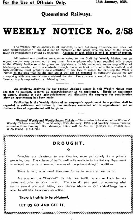
From 1936 to 1964, rail rebates were applied to railway lines that were declared as ‘drought-stricken’, a term considered similar to the current (2020) use of ‘drought declared’, and were listed in the Queensland Rail Weekly Notices until the late 1960s (see Fig. 1).
|
From 1936 to 1964 Queensland Railways proclaimed drought-stricken locations based on advice from its own officers and from the local stock inspector. Usually, a location proclaimed as drought-stricken was defined with respect to a relevant section of railway. In addition, rail freight concessions were applied to individual properties as certified by the local stock inspector, even if the property was outside the declared location (Queensland Drought Mitigation Committee 1966, p. 46, QDMC).
There were few instances where drought declarations did not use railway lines or railway stations as the basis for defining eligible relief, and an area description was used to cover all eligible properties, such as the listing of:
-
Barcoo, Bulloo and Quilpie Shires2 (Queensland Railways 5/1958); and
-
Boulia and Diamantina Shires, (Queensland Railways 18/1964).
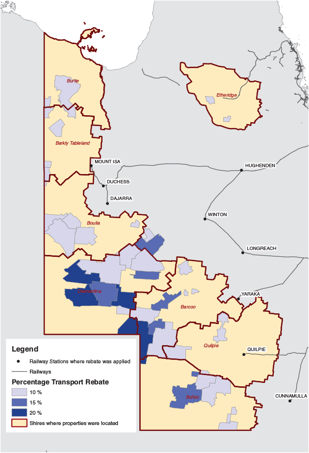
The rail rebates included an additional long-distance rebate for remote landholdings at a significant distance from the nearest railway station. Railway stations at Cunnamulla, Dajarra, Duchess, Hughenden, Longreach, Mount Isa, Quilpie, Selwyn, Winton, and Quilpie were designated for the long-distance rebate. Hence a drought declaration at these railway stations would, by default, allow the western Queensland LGA to access any drought relief. A list of landholdings is contained in Queensland Railways (44/1939; see Fig. 2).
|
Rebates for the restocking of cattle or sheep due to drought losses first appeared in 1937 (Queensland Railways 1/1937) for all livestock industries. A separate drought relief measure was also applied during 1937 for the south-east Queensland dairy industry under the provisions of the Drought Relief to Dairy Farmers Validation Act 1937 (Qld).
Further legislation, the Drought Relief to Primary Producers Act 1940–61 (Qld) provided a state treasury fund to provide drought relief (Anon. 1940) (Table 1).
Reform- and area-based drought declarations 1964–1968
Drought relief measures were reviewed during 1964–66, a period of extensive drought (QDMC 1966). During this period, there was an amalgamation of arrangements from the railway-based relief of the 1930s, together with an increasing focus on road transport, and towards more objective climate-based observations.
During the 1940s, the Queensland Department of Agriculture and Stock (QDAS) assisted in drought declaration policy, first in conjunction with the Queensland Railways Department, but by 1968 it became the lead agency. Drought declarations from 1964 to 1968 continued to be made based on railway lines and stations, but these were later realigned to LGA by the Rural Risk Strategies Unit (2008) in the light of continuing reforms.
By the early 1960s road transport was replacing rail for most rural industries within Queensland, and the system of drought declaration was recommended to be reviewed to consider all freight concessions (both rail and road) (QDMC 1966, p. 4). By 1968, drought declarations were based on local government areas as opposed to railway lines, reflecting the recommendations made by the QDMC.
Developments in road and rail services in promoting movement of stock and fodder were effective and important to drought mitigation (QDMC 1966, p. 4), and road permits for fodder and livestock were provided free-of-charge during 1965 (QDMC 1966, p. 45). However, a further review reported that the magnitude of the 1965 drought created an excessive demand for rail transport and for the movement of stock and fodder not conveniently served by rail. To meet these needs, free permits for road transport of stock and fodder were introduced (Committee on Drought Declarations and Rebates 1968; CDDR).
Mapping drought declaration areas 1936 to 1964
For mapping, it was necessary to specify the duration of individual droughts in order to compare drought declarations after 1964. Hence, a drought episode is described as the total time during which any drought declaration was in place in Queensland, until all declarations were revoked. Within the episodes, there are several ‘events’, defined as a railway line with a drought declaration and revocation date.
The mapping process is shown in Fig. 3 and was performed via ArcGIS 10.7 (ESRI 2020).

|
Data Sources
The following sources were used to compile drought declaration maps from 1936 to 1964:
-
Queensland Railways (1930–1965), which defined drought-stricken locations based on the railway network;
-
a composite Queensland Railway and Station spatial dataset (Queensland Government 2019b, 2019c); and
-
LGA mapping. This was based on the 1939 LGA boundaries (Queensland Government 1939). There were no major changes to these boundaries to 1964.
Railway drought declarations and revocations listed a start and end railway station, including urban stations as these were often listed. If the section of railway had a branch junction, the branch would be listed either as included or excluded as part of the drought declaration.
The Queensland Railway spatial layer (Queensland Government 2019b and 2019c) was modified to include railway stations and branch lines that were listed as drought declared, but since closed in recent times. An estimate based on the location of place names was used to plot the closed railways and these were added to a composite railway layer.
Drought declarations continued to be issued via the Railways weekly notices until 1965. For the purposes of this paper, Queensland Railway drought declarations were used until February 1964, and subsequent information obtained from the Rural Risk Strategies Unit (2008) was used to determine drought declarations. LGA-based declarations commenced in 1968 after the conclusion of the review by the CDDR Hence, the drought declaration locations were adjusted to LGA by the Rural Risk Strategies Unit (2008) between 1964 and 1968.
Estimating drought declaration areas
For this study, it was necessary to estimate the area of drought declarations from 1936, when area drought declarations began, to January 1964.
The literature search established that drought declarations from 1936 to 1968 were based on railway lines, and by applying an area buffer, a representation of the area was possible. To fully gauge the extent of drought declarations, a 100 km buffer based on the railway line was created for each event. The distance was based on a calculation of the median distance between all railway lines within Queensland. This is an estimate to incorporate any property that may have utilised the various railway rebates offered during the drought declaration.
As the 100 km buffer was based on railway lines, (Fig. 3) the area did not align with LGAs. Therefore, only areas that encompassed over 50% of a given LGA were included in the percentage area declared.
Estimating drought durations
For each declaration, the railway line was selected, and declaration and revocation dates added within the dataset. An individual section with a declaration and the revocation date would be listed as an event, and the number of days was calculated.
Estimation of a drought duration for each episode required consideration of the spatial overlap that commonly occurred in the buffer of each event (see Fig. 3). Within the overlap area, the duration calculation would be influenced by one or more drought declarations. Hence, an average duration was calculated by dividing the number of days by the number of drought events that occurred within each overlap in the 100 km buffer within an individual drought episode.
As the buffer areas do not fully incorporate the LGA areas, the median duration for each episode was calculated for each LGA area using ArcGIS zonal statistics tool (ESRI 2020). This spatial assessment of the average duration of drought was combined with the LGA maps to produce maps showing the average duration of drought for LGAs across Queensland between 1936 and 1963.
Extension to the drought area and duration datasets 1964–2020
The total area percentage of Queensland that was drought declared could be determined monthly by constructing an individual GIS dataset for each month. Therefore, individual datasets showing drought declared areas were calculated for all months back to December 1936, enabling the additional data to be added to the existing information, allowing for all drought declaration areas and their duration to be mapped for the whole of 1936–2020.
The drought declarations from 1964 to 1994 were summarised by Rural Risk Strategies Unit (2008) and from 1995, maps have been created by the Queensland Government.
All maps from 1964 have been published (LongPaddock 2020a).
Results
Drought policy
Current drought relief measures (Wade and Burke 2019, p. 13) originated from policies implemented from 1900 onwards. Land rent subsidies during drought were first applied via the Pastoral Leases Act 1900 (Qld). Fodder and water freight subsidies were first applied in 1915. Stock transport, agistment and restocking relief measures were applied in 1915 for 12 months, and reintroduced for all drought declarations from 1937. All the subsidies were first applied to the railway network, and then extended to the road transport during 1963–1964. The drought declaration process also has similar origins where IDPs were first made in 1915, and drought declarations (albeit based on railways) commenced in late 1936 and become LGA based by 1968.
Spatial extent of droughts 1936–1964
From 1936 to 1964, 13 drought episodes were recorded. During the late 1950s and ’60s, drought declaration locations increased in frequency and complexity. Between May 1957 and January 1959 there were 22 declarations and 32 revocations. The subsequent drought from August 1960 to May 1962 had 55 declarations.
In most instances, particularly after the mid-1950s, the drought revocation area would differ from the original drought declaration area. Hence, a classification scheme was employed to track each declaration (Table 2). Episode 11 was particularly complex. During the 22 months of Episode 11, 105 events were mapped across the railway network, with some areas having multiple declarations.

|
Duration of droughts 1936–2020
Fig. 4 shows examples of the longest drought declarations for the period 1936–1964.

|
The percentage area drought declared for Queensland from December 1936 to June 2020 (Fig. 5) incorporates the published drought declaration maps from January 1963 to present (LongPaddock 2020a).

|
Discussion
Drought policy
The first drought relief measures were land rent reductions (Anon. 1897, 1899) based on a schedule of pastoral leases listed in the Pastoral Leases Act 1900 (Qld). Drought relief was offered for all primary industries, via individual properties from 1915, albeit with a focus on dairy industries. Subsequently, drought declarations in Queensland were first implemented through the legislative and subsequent regulation of the dairy industry a consequence of the 1918–1924 drought within south-east Queensland via the Primary Producers Co-operative Associations Act (Anon. 1923e). This paper substantiates that the application of various railway rebates to area locations was central to drought relief, as rail was considered the main transport corridor for pastoral industries at the time.
Rebates were considered an appropriate drought relief measure, as most Queensland rural industries were accessible to a railway and via designated stock routes. Examples of the importance of railways and planning during this period can be seen in the publication of maps showing the railway network with cattle and sheep populations either as a one-degree grid or within petty session district boundaries maps (Commissioner of Railways 1908, 1913).
Drought relief initiated in 1915 was managed for individual properties. However, by 1936, the volume of applications necessitated location declarations. The drought declaration areas were loosely defined by railway lines and stations, and, within these boundaries, property owners would be entitled to access subsides for stock and fodder transport.
By the late 1950s, the first LGA drought declarations were being applied by Queensland Railways, but these were the exception, as only two areas outside the railway corridors were declared by 1958.
Extended drought conditions during the 1960s led to reforms with the CDDR (1968, pp. 10–11) promoting the advantages of a drought area declaration, where declarations:
-
are made where the majority of properties in the area are affected by drought to ensure that the area declared is the result of inadequate rainfall rather than a situation produced by bad management;
-
would eliminate claims of favouritism in the certification of individual properties as drought declared;
-
will continue the granting of the rail freight rebate on fodder at the time of consignment. The rail freight on livestock moving from the property could be granted at the time of consignment whether the basis is area declaration or individual property certifications; and
-
would ease the administration pressure on departmental staff by reducing the need for individual property certifications.
IDP certifications (an approach used since 1915) were considered advantageous to individual landholders in that they allowed early drought relief to be provided to affected producers, noting that a time-delay would occur before an area declaration could be made for any district (CDDR 1968, p. 11). Current policy continues to reflect this mechanism, where IDP can be applied for before any area declaration and then are incorporated into the area declaration if made.
The increasing use of road transport was also considered by the CDDR The CDDR (1968, p. 11) reported discrepancies in the access of rail rebates and road permits due to the inconsistent application of individual property certifications and area declarations. The CDDR (1968, p. 15) made the following recommendations, where:
-
a uniform criterion to be applied to both rail and road transport systems;
-
the use of railway section declarations to be continued, but to be expanded to LGAs; and
-
stock inspectors are to evaluate local conditions before a drought declaration is to be removed.
By 1968–1969, the concepts of IDP and LGA declarations were the mechanism for releasing the various components of drought assistance, and were consistent with the funding and assessment criteria from the Drought Relief Assistance Scheme and additional Australian Commonwealth Government funding. The LGA drought declarations from 1964 to 1968 provided by the Rural Risk Strategies Unit (2008) were likely backdated, as railway drought declarations continued during 1964–1965. By 1982, drought declarations were considered by local drought committees (LongPaddock 2020b), further formalising the processes developed previously from 1936 that included the use of local experts in the declaration process (Anon. 1923d).
The concept of primary industry support for drought relief has been discussed by Heathcote (1969) and the Land Settlement Advisory Commission (1959, p. 624) primarily on grounds of economic sustainability, where a view was reached that numerous publicly funded schemes (including drought relief) have compounded graziers’ debts. Daly (1994, p. 92) followed a similar argument, claiming that the drought declaration process used before 1982 increased the frequency and duration of official droughts, and raised the possibility that this may be due to primary producer dependency on subsidies.
Spatial extent of drought
Several far western Queensland LGA (Burke, Barcoo, Barkly Table, and now Mt Isa City Council, Boulia, Bulloo, and Diamantina shires) was noted by Day et al. (2005, p. 380), as never being drought declared before 1964.
A possible explanation is that, since the railway network did not extend into far western shires, drought declarations would only have applied at the end stations (see Fig. 2), although the Barcoo and Bulloo Shires (Queensland Railways 5/1958) and Boulia and Diamantina Shires (Queensland Railways 18/1964) were listed as drought declarations.
However, long distance rebates were applicable to a list of stations (Queensland Railways 44/1939). These rebates offered freight concessions similar to the range of drought rebates and were not subject to a time period. These pastoral properties were listed in a schedule which increasingly expanded to over 100 locations from 1925 to 1968, including 20 properties in the adjoining Northern Territory.
Hence, it can be argued that properties listed in the schedule were under similar rebate arrangements applicable during any drought declaration. However, if a railway station listed as a distribution point for the long-distance rebate (see Fig. 2) became an end station during a drought declaration, additional assistance would be available for far western properties.
Duration of drought
When comparing rainfall deficiencies during 1964–1994, Day et al. (2005, p. 375, 380, fig. 29.5) state that the duration of drought declarations has increased by 10% since the 1980s. Day et al. (2005) concluded that this increase was due to the higher revocation threshold being used for pastures to be re-established for the return of livestock after drought.
The increased duration of drought declarations (Fig. 5) appears symptomatic of change to the decision to end the declaration (i.e. revocation), possibly due to the implementation of Local Drought Committees in 1982 (LongPaddock 2020b). Prior to this change, transport concessions were available for the return of livestock when ‘conditions of such pastures permit a return’ from 1952 (Queensland Railways 16/1952).
Daly (1994, p. 92), in a review of Queensland drought declarations from 1962 to 1994, also noted increasing declaration durations, and suggested that this was systematic of a dependency on subsides to primary producers and was causing an inequitable distribution of drought relief (Stafford Smith and McKeon 1998, p. 272). These authors discussed drought revocation criteria, and concluded that there are many criteria options available, and these must be an integral part of the declaration process.
Currently, the revocation criteria are that adequate pasture be present for two months before the revocation date, and for 12 months after the revocation date or, in special circumstances, extended to 24 months (Wade and Burke 2019, p. 15; QPAEC 2017, p. 5).
The local drought committees (LongPaddock 2020b) would recommend drought revocation if livestock had sufficient pasture and water to last until the next expected rainfall, usually the subsequent wet season. Prior to 1982, drought revocations appeared to have been made without this consideration, possibly extending drought declaration durations from 1982 (Fig. 5).
Conclusions
Drought needs to be considered in the context of its contemporary economic situation, a view echoed by Heathcote (1969, 1988). Modern primary production is more capital intensive compared with the labour demands before wide-spread industry mechanisation from the 1920s, particularly stock transport. Hence, Queensland drought declarations of more recent times reflect a more modern industry, with better developed road and property water infrastructure.
Improving the objectivity of the declaration and revocation processes is an aim for a fair and cost-effective drought relief policy (Queensland Government 2019d); this paper provides some insight into the historical development of this mechanism. Drought declarations are and have been subjective, and have complex economic, environmental and industry demands.
By assembling drought declaration locations and durations as used by Queensland Railways from 1936 to 1964, and then applying an area buffer to the locations, a time series of drought declaration (area and duration) information for Queensland was generated, from 1936 to 2020. Drought revocation policies applied since 1982 have appeared to extend the duration of drought declarations.
Conflicts of interest
The author declares no conflicts of interest.
Acknowledgements
This study was funded by the Queensland Department of Agriculture and Fisheries through the Drought and Climate Adaptation Program (DCAP) and the Queensland Government’s Queensland Reef Water Quality Program. A special mention is made for Rob Shiels of the Workshops Rail Museum (North Ipswich, Queensland) who provided a digital copy of the Queensland Rail Weekly Notices. The author wishes to express special thanks to Christina Jones, Greg McKeon, Jacqui Willcocks and the anonymous reviewers for their constructive critique and suggestions during the drafting and review of this paper.
References
Anon. (1897). ‘Report of Land Commission.’ The Brisbane Courier, 3 June, p. 5. Available at: http://nla.gov.au/nla.news-article3652030 (accessed 28 November 2019).Anon. (1899). ‘Pastoral Leases – a representative deputation.’ The Brisbane Courier, 12 September, p. 7. Available at: http://nla.gov.au/nla.news-article3701451 (viewed 28 November 2019).
Anon. (1915a). ‘Relief of Starving Stock.’ The Brisbane Courier, 12 July, p. 4. Available at: http://nla.gov.au/nla.news-article20052499 (accessed 28 November, 2019).
Anon. (1915b). ‘Relief Measures.’ Darling Downs Gazette, 7 December, p. 5. Available at: http://nla.gov.au/nla.news-article182683971 (accessed 4 December 2019).
Anon. (1916a). ‘Wheat and Fodder.’ The Brisbane Courier, 10 February, p. 5. Available at: http://nla.gov.au/nla.news-article20079613 (accessed 4 December 2019).
Anon. (1916b). ‘The Week at a Glance.’ The Queenslander, 5 February, p. 11. Available at: http://nla.gov.au/nla.news-article23601884 (accessed 4 December 2019).
Anon. (1916c). ‘Brisbane News – Relief for Farmers – Fodder and Wheat Distribution.’ Queensland Times, 10 February, p. 5. Available at: http://nla.gov.au/nla.news-article113142423 (accessed 4 December 2019).
Anon. (1923a) ‘Drought Stress.’ The Brisbane Courier, 1 June, p. 9. Available at: http://nla.gov.au/nla.news-article20624991 (accessed 28 November 2019).
Anon. (1923b) ‘Primary Industries – Effect of Drought.’ The Brisbane Courier, 28 November, p. 8. Available at: http://nla.gov.au/nla.news-article20694634 (accessed at 28 November 2019).
Anon. (1923c) ‘Primary Industries – Effect of Drought.’ The Queenslander, 15 December, p. 15. Available at: http://nla.gov.au/nla.news-article22650276 (accessed 1 December 2019).
Anon. (1923d) ‘Drought Relief.’ The Brisbane Courier, 23 October, p. 4. Available at: http://nla.gov.au/nla.news-article20657764 (accessed 28 November 2019).
Anon. (1923e) ‘Co-Operative Companies.’ The Brisbane Courier, 5 October, p. 8. Available at: http://nla.gov.au/nla.news-article20637948 (accessed 28 November 2019).
Anon. (1935). ‘Rebates on Freight.’ The Courier Mail, 22 March, p. 18. Available at: http://nla.gov.au/nla.news-article35877064 (accessed 29 November 2019).
Anon. (1937). ‘Drought Aid Bill.’ Queensland Country Life, 4 November, p. 1. Available at: http://nla.gov.au/nla.news-article97175518 (accessed 2 December 2019).
Anon. (1940). ‘Drought-Stricken Farmers.’ The Courier Mail, 25 October, p. 5. Available at: http://nla.gov.au/nla.news-article40937684 (accessed 2 December 2019).
Commissioner of Railways (1908). Map of Queensland to Accompany the Commissioner for Railways Report for 1906–07 shewing the Several Railways Systems and Branch Lines, The Principal Railways Stations and Towns also the Distribution of Livestock throughout the State of Queensland (composite photocopy).
Commissioner of Railways (1913). Map of Queensland to Accompany the Commissioner for Railways Report for 1911–12 shewing the Several Railways Systems and Branch Lines, The Principal Railways Stations and Towns also the Distribution of Livestock throughout the State of Queensland (composite photocopy).
Committee on Drought Declarations and Rebates (CDDR) (1968). Report of the Committee on Drought Declarations and Rebates. Queensland Department of Primary Industries, Brisbane, Qld.
Daly, D. (1994). Wet as a shag, dry as a bone: drought in a variable climate. QI93028 Queensland Department of Primary Industries, Brisbane, Qld.
Day, K. A., Rickert, K. G., and McKeon, G. M. (2005). Monitoring agricultural Drought in Australia. In ‘Monitoring and Predicting Agricultural Drought: A Global Study’. (Eds V. K. Boken, A. P. Cracknell and R. L. Heathcote.) pp. 369–384. (Oxford University Press: New York.)
ESRI (2020). ‘ArcGIS Desktop: Release 10.7.’ (Environmental Systems Research Institute: Redlands, CA, USA.)
Heathcote, R. L. (1969). Drought in Australia: a problem of perception. Geographical Review 59, 175–194.
| Drought in Australia: a problem of perception.Crossref | GoogleScholarGoogle Scholar |
Heathcote, R. L. (1988). Drought in Australia: still a problem of perception? GeoJournal 16, 387–397.
| Drought in Australia: still a problem of perception?Crossref | GoogleScholarGoogle Scholar |
Joint Select Committee on Australia Fund Establishment (2015). Drought assistance. Commonwealth of Australia, Canberra. Available at: https://www.aph.gov.au/Parliamentary_Business/Committees/Joint/Australia_Fund_Establishment/Australia_Fund_Establishment/Report/c02 (accessed 8 January 2021).
Kerr, R. (2018). Part 5: Key Legislation for Land Selections since 1860, summarised. Queensland State Archives. Available at: https://blogs.archives.qld.gov.au/2018/04/03/part-5-key-legislation-for-land-selections-since-1860-summarise (accessed 21 October 2019).
Land Settlement Advisory Commission (1959). ‘Report on progressive land settlement in Queensland.’ (Government Printer: Brisbane, Qld.)
LongPaddock (2020a). Drought declarations archive. Available at: https://www.longpaddock.qld.gov.au/drought/archive/ (accessed 28 April 2020).
LongPaddock (2020b). Local Drought Committee Guidelines. Available at: https://data.longpaddock.qld.gov.au/Drought/LDC+Guidelines+Web+Accessible+2018.pdf (accessed 28 April 2020).
Queensland Drought Mitigation Committee (QDMC) (1966). Drought problems in Queensland: a report of the representative committee on drought problems. Department of Primary Industries, Brisbane.
Queensland Government (1939). ‘Queensland Yearbook.’ (Government Statistician: Brisbane.)
Queensland Government (2019a). Open Data Portal. 4 mile first series 1905–1942 – Queensland cadastral maps. Available at: https://www.data.qld.gov.au/dataset/4f5b4c2f-4578-4737-b199-53347b60345d/resource/81a93df6-f5ae-41f1-926c-f3b1b99d974a/download/4mile-queensland-first-series-1905-1942.csv (accessed 15 December 2019) (spatial data).
Queensland Government (2019b). Railways stations and sidings. Available at: http://qldspatial.information.qld.gov.au/catalogue/custom/detail.page?fid={FF83FBFE-5190-4350-802A-5B73E3954296} (accessed 15 December 2019) (spatial data).
Queensland Government (2019c). Railway network – Queensland. Available at: http://qldspatial.information.qld.gov.au/catalogue/custom/detail.page?fid={8C0F5D96-96C0-4510-8D67-445A0E92893A} (accessed 15 December 2019) (spatial data).
Queensland Government (2019d). Response to Drought Program Review. Available at: https://www.publications.qld.gov.au/dataset/drought-program-review-report/resource/f776c8ed-670d-4b9e-91ef-4dae429365dc (accessed 30 April 2020).
Queensland Parliament Agriculture and Environment Committee (2017). (QPAEC). Review of the Drought Relief Assistance Scheme. Report No. 29, 55th Parliament. Parliamentary Committees, Brisbane. Available at: https://cabinet.qld.gov.au/documents/2017/Apr/Drought/Attachments/Report.PDF (accessed 12 January 2020).
Queensland Railways (1930–1965). ‘Queensland Rail Weekly Notices.’ (Queensland Government Printers: Brisbane.)
Rural Risk Strategies Unit (2008). Queensland Drought Declarations, 1964–2008. Department of Primary Industries and Fisheries Brisbane. Unpublished report.
Stafford Smith, D. M., and McKeon, G. M. (1998). Assessing the historical frequency of drought events on grazing properties in Australian rangelands. Agricultural Systems 57, 271–299.
| Assessing the historical frequency of drought events on grazing properties in Australian rangelands.Crossref | GoogleScholarGoogle Scholar |
Wade, R., and Burke, C. (2019). Drought Program Review (Queensland). Queensland Government, Brisbane. Available at: https://www.publications.qld.gov.au/dataset/daf8f174-4ddf-4983-975d-ac6e717a9cf8/resource/16b7b036-2068-4ba6-b8d4-edb95fd1c1dd/fs_download/drought-program-review-report.pdf (accessed 12 January 2020).
1 Queensland Railways weekly notices are referenced by the week number in a particular year, hence, 20/1930 is the 20th week of 1930. This referencing is continued for the whole of the paper.
2 In Queensland, shires were the geographical term used for what is currently termed local government areas (LGA) that were considered as non-urban. For this paper shire is interchangeable with LGA as historical references retain the word shire.