

Rehabilitating vegetation and demonstrating co-benefits in highly degraded rangelands draining to the Great Barrier Reef: seven things to consider
Rebecca Bartley A B * , Brett Abbott C , Bruce Murray C , Anne Kinsey-Henderson C and Aaron Hawdon C
A
B
C
Abstract
Knowledge from landscape rehabilitation monitoring is urgently needed to support Australia’s Nature Positive agenda and accelerate recovery from landscape degradation. This paper presents pasture recovery data from four paired (control and treatment) erosion rehabilitation sites in the Burdekin catchment, Australia. The treatments ranged from approaches using grazing management only, to more expensive engineering options. The effectiveness of each of the treatments on vegetation recovery was evaluated using (i) field monitoring data (% cover, biomass, defoliation and % native ground cover plant species), collected over period ranging from 3 to 8 years, and (ii) remote sensing data (Landsat; 1990–2023) to provide a longer-term perspective of land cover change, and to determine whether remotely sensed data adequately captures the recovery. The outcomes for runoff and water quality have been evaluated in a companion paper. The field measurements also provided insights into the potential co-benefits from the rehabilitation, including pasture biodiversity (% native plant species) and biomass productivity for grazing (biomass, kg ha−1 pasture). The observations and lessons learnt from these studies, with other insights from the literature, were synthesised to inform the next generation of rehabilitation sites in similar rangeland environments. The key points included the following: (1) detecting change is challenging and may take decades, so pack your patience; (2) remote sensing is useful, but needs to be calibrated using on-ground measurements; (3) active rehabilitation is likely to demonstrate changes much more quickly, but it will be very costly; (4) aligning production and environmental outcomes will be challenging; (5) if you want to capture biodiversity co-benefits, think strategically about revegetation species selection in the planning phase, and consider co-benefits at whole of property scales; (6) vegetation can reduce runoff downstream but we will need to scale up; and (7) not all areas can or should be rehabilitated – select sites carefully.
Keywords: erosion, grazing, land management, monitoring, nature repair, rehabilitation, restoration, vegetation.
Introduction
During the UN decade on ecosystem rehabilitation (https://www.decadeonrehabilitation.org/), there is heightened focus on the methods, approaches and outcomes for restoring degraded landscapes (e.g. Gann et al. 2019; Waltham et al. 2020; Mappin et al. 2022). Landscape rehabilitation (which may be used synonymously with restoration, remediation, reclamation, repair and enhancement) (BenDor et al. 2015) is used to describe the improvement of land from its current state. In this study, we use the term rehabilitation to describe the process of replacing key eco-hydrological functions that have been disturbed.
Landscape degradation is widespread across rangelands globally (Zerga 2015) and is well documented in Australia (McKeon et al. 2004), with climate change and failure to respond to it expected to further stress these ecosystems (Godde et al. 2020). Rangeland areas that have poor vegetation cover, either through over-grazing, fire or other disturbances, have higher rates of runoff and erosion (Bartley et al. 2006), with the logic being that if the vegetation can be re-instated, both runoff and erosion will reduce. However, rangeland environments, which often have extreme rainfall regimes, can be hard to restore (Walling and Kleo 1979), and although there are some spectacular examples of rehabilitation success (e.g. Payne et al. 2004), these have occurred only with considerable financial investments in areas where the cost of rehabilitation is justified by the value of the asset that is being protected (e.g. dam water supply, or World Heritage Area Reef). Despite considerable investment into rehabilitation globally, evidence demonstrating the effectiveness of rehabilitation treatments on attributes such as vegetation and water quality is rare at site scales, and even scarcer at whole of catchment scales (Kroon et al. 2014; Melland et al. 2018). Specifically, there is a lack of long-term vegetation data from paired control and treatment sites, comparing different rehabilitation approaches. This knowledge gap hampers our ability to evaluate the success of rehabilitation efforts and refine practices for better outcomes.
The catchments draining to the GBR have received considerable attention and investment into agricultural land management and landscape repair over the recent decades to reduce the amount of sediment and nutrients delivered to the GBR World Heritage Area (https://www.dcceew.gov.au/parks-heritage/great-barrier-reef/protecting/our-investments/reef-trust). Landscapes will produce excess sediment when there is bare ground and/or excessive runoff, which facilitates erosion. Gullied landscapes, which can produce high excess anthropogenic sediment yields (Olley et al. 2013; Wilkinson et al. 2013; Bainbridge et al. 2023), have been the focus of landscape rehabilitation globally (Bartley et al. 2020; Frankl et al. 2021) and in the GBR catchments (e.g. Doriean et al. 2021; Koci et al. 2021; Brooks et al. 2024; Khan et al. 2024).
The global experience in relation to gully repair reviewed by Bartley et al. (2020) suggests that when remediating severely gullied landscapes, it is important to combine both engineering, soil treatment and vegetation management. Rehabilitation may involve interventions such as engineering structures (e.g. re-contouring, diversion banks, check dams), which are often needed in the initial phase of rehabilitation to help stabilise gullied sites and reduce erosion (e.g. Brooks et al. 2024). Engineering structures can create conditions that allow for the treatment of soil and the establishment of vegetation, especially in harsh plant growth conditions (e.g. low rainfall, degraded soils, or very steep slopes). However, most engineering structures are known to fail within a few decades (Bartley et al. 2020; Frankl et al. 2021). Therefore, supporting active engineering approaches with vegetation establishment and maintenance is critical for supporting the eco-hydrological recovery of the site in the long-term.
In the GBR catchments, many rehabilitation sites were initially implemented to achieve reduced runoff and erosion, but they are increasingly expected by funding bodies to also achieve agricultural production, social, ecological and/or carbon co-benefits (e.g. see https://www.qld.gov.au/environment/climate/climate-change/land-restoration-fund). Co-benefits can be obtained by combining erosion control with carbon sequestration (Baumber et al. 2019) and biodiversity outcomes (Dybala et al. 2019). There is also a growing interest in communities seeking social, economic and indigenous co-benefits from land restoration (Dumbrell et al. 2024). Increased focus on co-benefits is considered a way to improve adoption and uptake of rehabilitation (Fleming et al. 2019). It was not the purpose of this study to exhaustively map out the co-benefits for these projects; however, using the collected vegetation data, there was an opportunity to examine the potential for co-benefits to be realised from these investments. Whether rehabilitation can effectively meet multiple co-benefits is yet to be adequately tested in rangeland environments.
To help improve our understanding of the approaches and potential outcomes from landscape rehabilitation in rangelands, this study had three main objectives. First, the paper presents vegetation data collected from four paired control and treatment gully sites in the Burdekin catchment in north-eastern Queensland. A total of ~AUD$2.5 million was spent across the four sites. Data were collected from sites with advanced gully erosion, that had undergone a spectrum of rehabilitation approaches ranging from using grazing management only, to various active landscape repair approaches (that include soil amelioration, diversion banks, engineering re-shaping and re-seeding) over a period of between 3 and 8 years. The second objective of this paper was to apply the Compere framework (Donohue et al. 2022, 2023) to determine whether the rehabilitation approaches at the treatment site can be detected remotely. The third and final objective of this paper was to synthesise the observations and lessons learnt from these studies, with other key insights from the literature, to help inform the next generation of rehabilitation sites in the GBR catchments and similar rangeland environments. By evaluating the effectiveness of different rehabilitation strategies and their ability to deliver multiple benefits, we aim to provide guidance for policy and management groups trying to optimise rehabilitation investments. This study represents one component of a larger body of work. The response of the interventions on runoff and sediment loads will be presented in a companion paper (A. A. Hawdon, R. Bartley, A. Kinsey-Henderson, S. N. Wilkinson, J. Marano, K. Mitchell, B. N. Abbott, J. Morris, B. Murray, unpubl. data). This paper presents changes to the vegetation data only.
Study sites and rehabilitation approaches
Selection of experimental sites
All sites included in this study are in the Bowen–Bogie subcatchment within the Burdekin region of Queensland, Australia (Fig. 1). The Burdekin catchment, covering approximately 130,000 km2, drains into the GBR Lagoon south of Townsville on Australia’s eastern coast. It is the largest contributor of anthropogenically-derived fine sediment to the GBR lagoon (McCloskey et al. 2021; Waterhouse et al. 2024b). This region is dominated by semi-arid eucalypt woodlands, typically with a history of tree thinning and widespread livestock grazing since ~1860 (Lewis et al. 2021). The combination of highly erodible sodic soils, periods of excessive grazing pressure and droughts, have led to severe erosion in parts of the Burdekin (McKeon et al. 2004; Lewis et al. 2021). The Broken–Bogie–Bowen (BBB) subcatchment (11,700 km2) is recognised as one of the most significant sources of anthropogenic sediment to the GBR (Bartley et al. 2015; Mariotti et al. 2021; Bainbridge et al. 2023) (Fig. 1).
Map of the Bogie–Broken–Bowen (BBB) catchment (within the Burdekin, see inset), showing the location of the properties in this study.
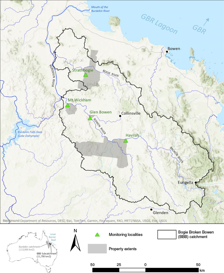
Eight sites across four commercial grazing properties were included in this study (Table 1). The properties represent a range of geology, soil type, rainfall and gully types, and they are listed in order from the longest monitoring data set (8 years) to the shortest (3 years) (Table 2). The selection of treatments was determined by NQ Dry Tropics, the regional body contracted to deliver the remediation works, in collaboration with landholders and various landscape restoration contractors. The authors of this study did not have any input into the choice, location or selection of treatment options.
| Property | Strathbogie | Mount Wickham | Glen Bowen | Havilah | |
|---|---|---|---|---|---|
| Subcatchment | Bogie | Bowen | Bowen | Bowen | |
| Size of property (ha) | ~39,000 | ~7790 | ~930 | ~72,600 | |
| Location Treatment Gully | −20.2214, 147.5566 | −20.4624, 147.4019 | −20.572624, 147.593225 | −20.763526, 147.895689 | |
| Location Control Gully | −20.204, 147.5581 | −20.4650, 147.4071 | −20.560498, 147.591485 | −20.763992, 147.891364 | |
| Geology | Granite, Basalt | Granite and Granodiorite | Mafic Intrusives | Siliciclastic sedimentary, acid volcanic and intrusive rocks; minor basaltic rocks also occur throughout | |
| Soils | Black Vertosol | Hypernatric Brown Sodosol | Brown or Yellow Sodosols | Vertosols to south of gullies and Chromosols to north; Tenosols and Sodosols in the upper slopes | |
| Average rainfall over study (mm) based on rain gauges | 730 | 780 | 650 | 730 | |
| Average long-term (1900–2023) rainfall at site (mm) A | 640 | 630 | 610 | 570 | |
| Vegetation overstorey | Open woodland of Eucalyptus crebra and Corymbia erythrophloia dominant; includes localised areas dominated by Eucalyptus persistens | Sparse Eucalyptus crebra and Corymbia erythrophloia with a mixed species understorey | Moderate to sparse Eucalyptus crebra and Corymbia dallachiana + Eucalyptus persistens; no overstorey on the treatment site, which appears to have been cleared in the past | Eucalyptus persistens dominant with Corymbia dallachiana and Eucalyptus crebra sparsely populated on the control site to moderate on the treatment site | |
| Vegetation groundcover | Dominated by Bothriochloa pertusa | Dominated by Bothriochloa pertusa | Dominated by Bothriochloa pertusa | Cenchrus ciliaris dominant at control site and Bothriochloa pertusa and Urochloa mosambicensis dominant at treatment | |
| Gully type | Linear hillslope gullies | Linear hillslope gullies, scalds and major alluvial gullies | Scalds and major alluvial gullies | Scalds and major alluvial gullies |
| Activity | Strathbogie | Mount Wickham | Glen Bowen | Havilah | |
|---|---|---|---|---|---|
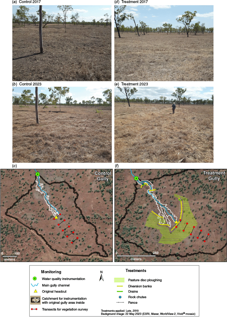
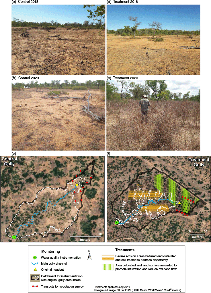
| Engineering treatments at the active (treatment) gully site. | Hillslope flow diversion banks with two drains and small rock chute (Fig. 2). | Combination of grade control rock chutes, re-contouring of the eroded gully surface. The land surface was cultivated and treated with fertiliser and soil ameliorants (e.g. zinc sulfate, gypsum and organic matter) (Fig. 3). | Cut-and-fill and compaction earthworks; three smaller gullies and six scalded areas were reshaped. Two rock cut-off walls were constructed downstream of the reshaping and rock check dams along the contours. Soil treatment using gypsum (Fig. 4). | Reshaping of gully heads, construction of rock chutes and diversion banks, soil amelioration, seed spreading, permeable hay contour banks and some minor rehabilitation of road and tracks (Fig. 5). | |
| Vegetation management and fencing at treatment sites. | Ploughing pasture above treatment gully (using a yeoman’s plough disc and tine), but no direct seeding. Reduced grazing intensity. Permanent 3-barb fence for stock management. | Significant re-vegetation using mixed exotic pasture species, several native canopy species and some legumes (see Table S1 in Supplementary Material for species list). Permanent 4 barb fence. | Re-vegetation using mixed exotic species (see Table S2 in Supplementary Material for species list). Permanent 3 barb fence + pipeline and off-site waterpoints. | No additional vegetation introduced at vegetation monitoring sites. Grazing management only. Fencing in Year 3 [note that the area treated with seed was not near the vegetation monitoring sites]. | |
| Year site monitoring began. | 2016 | 2018 | 2019 | 2020 | |
| Year treatment was initiated. | Late 2019 | Early 2019 | Late 2019 | March 2022 | |
| Number of years of control/treatment monitoring. | 8 (noting the 2017/2018 data were not collected due to access issues following a major rain event, so only 7 years of data presented). | 6 | 5 | 3 | |
| Number of years treatment in place. | 5 | 5 | 4 | 2 | |
| Years of pre-treatment data. | 3 | 1 | 1 A | 1 | |
| Total cost (AUD$) of on-ground works. | ~$44k | ~$595k | ~$840k | ~$982k [~$505k for phase 1 + $477k for phase 2] |
On each property, there was a control site that did not undergo treatment, and a treatment site that underwent a range of rehabilitation approaches (Table 2). Treatment and control sites were selected that had the same soil type and vegetation community. All sites had control and treatment gullies; however, because of the timing of both project funding and wet seasons, the number of pre-treatment years of data varied among sites (Tables 2, 3).
| Treatment | Strathbogie | Mount Wickham | Glen Bowen | Havilah | |
|---|---|---|---|---|---|
| Soil disturbance via ploughing to increase infiltration | √ | ||||
| Runoff diversion banks | √ | ||||
| Land surface re-shaping | √ | √ | |||
| Chemical soil treatment (e.g. gypsum) | √ | √ | |||
| Re-seeding with mixed exotic grass species (see Supplementary Material) | √ | √ | |||
| Re-seeding with native tree species (see Supplementary Material) | √ | ||||
| Fencing | √ | √ | √ | ||
| Stock management | On both control and treatment hillslopes for all sites (see Table 4) | ||||
We predicted greater effectiveness of treatments that combined a range of approaches, and where treatments had been in place for longest. The data collected (% cover, biomass, defoliation and % native species) provide insights into the vegetation changes that occur following treatment either as engineering activities or grazing management. These data also provide insights into the potential co-benefits including biodiversity (% native species) and grazing biomass productivity (biomass, kg ha−1 pasture).
Detailed soil descriptions and chemical analysis were undertaken by different groups at each of the field sites following the Australia Soil Classification system (Isbell 2002). Queensland State Government and CSIRO staff were responsible for the soil analysis at Strathbogie and Mount Wickham. Soil chemical analyses for these sites were undertaken at the Queensland Department of Environment and Science Labs in Brisbane, and all the data are stored in Queensland Globe (P2REEF – https://qldglobe.information.qld.gov.au/). Detailed descriptions of the soils at Glen Bowen were presented in Stout et al. (2019) and soil descriptions for Havilah Station were taken from ASRIS, with some local soil samples collected for determining silt and clay content. The average annual rainfall (mm) for the monitoring period at each site, relative to the long-term average, is given in Table 1. The annual average rainfall during the measurement period for each of the properties was captured using rain gauges installed at each of the eight sites. The long-term (~120-year) rainfall data were derived from SILO gridded rainfall (https://www.longpaddock.qld.gov.au/silo/). The rainfall season is calculated from July to June each year.
Rehabilitation approaches
The rehabilitation sites were located on working cattle stations, meaning that compromises were sometimes required in terms of activities, materials and placement of infrastructure such as fencing. Given the gully types and erosion features varied among properties, direct comparison of the rehabilitation approaches is difficult; however, generic insights were captured across the range of sites.
Table 2 outlines the broad engineering and vegetation treatments at each of the study sites as well as the timeframes over which data were collected at each site. The specific treatments evaluated in this study are presented in Table 3, and the location of the vegetation transects are shown in Figs 2–5. A list of the vegetation species applied at the treatment sites at Mount Wickham and Glen Bowen are provided in Supplementary Table S1 and S2. Although Havilah gully treatment site also had re-seeding, this paper specifically evaluated the hillslope paddock revegetation component of that site, and no re-seeding occurred in the area monitored for this study (see Fig. 5).
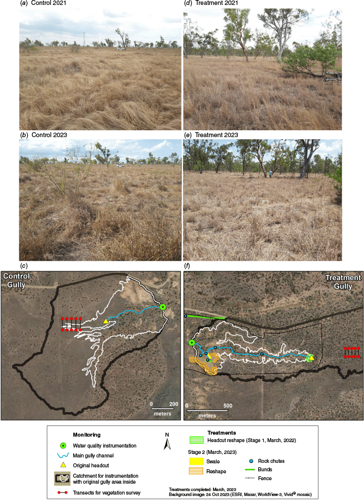
Strathbogie site showing (a–c) Control and (d–f) Treatment sites. The location of the treatment structures and monitoring equipment/locations are shown in (c) and (f). Vegetation surveys are upstream of the water quality instrumentation, which are at the lowest point in the catchment. An area of ~30% of the catchment above treatment gully is beyond map extent shown. Fences are also beyond map extents.
Mount Wickham site showing (a–c) Control and (d–f) Treatment sites. The location of the treatment structures and monitoring equipment/locations are shown in (c) and (f). Vegetation surveys are upstream of the water quality instrumentation, which are at the lowest point in the catchment. Fences are also beyond map extents.
Glen Bowen site showing (a–c) Control and (d–f) Treatment sites. The location of the treatment structures and monitoring equipment/locations are shown in (c) and (f). Vegetation surveys are upstream of the water quality instrumentation, which are at the lowest point in the catchment. Catchment area and gully area for the Treatment Gully are the same. Fences are beyond map extents.
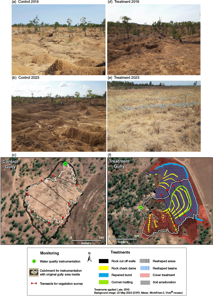
Havilah site showing the (a–c) Control and (d–f) Treatment sites. The location of the treatment structures and monitoring equipment/locations are shown in (c) and (f). Vegetation surveys are upstream of the water quality instrumentation, which are at the lowest point in the catchment; ~50% of catchment area above treatment gully is beyond map extent shown in (f). Treatment vegetation monitoring was positioned to be in the line of flow of the gully channel, noting that the fencing placement occurred 2 years after monitoring began.
The timing of the rehabilitation relative to rainfall can have a major influence on the success of the rehabilitation. For example, within the first 24 h of rehabilitation works being completed at Mount Wickham, an intense rainfall event occurred at this site delivering ~320 mm of rain in 72 h. This event had benefits in that it provided great growing conditions for freshly applied seeds; however, it also meant that a very large percentage of the blended and sown seed was likely to have been washed from site.
Grazing management
To support long-term maintenance at the gully rehabilitation sites, there was an expectation that careful grazing land management (GLM), and a period of stock exclusion, would occur at the rehabilitation sites. Landholders were requested to provide stocking rate data to provide an estimate of grazing pressure at each site. However, data provided were inconsistent, with some years, particularly pre-treatment conditions, having missing information. It is acknowledged that stocking rate (number of cattle per hectare) and stocking method (intensive rotations vs continuous grazing) can be confounded (Hall et al. 2014) and the variety of approaches used by landholders may make comparisons among sites challenging. This study did not aim for precise stocking rate data; rather, it sought rough estimates of grazing pressure before and after treatment.
Two approaches were used to estimate grazing pressure. Where landholders provided data (e.g. number of cattle in a paddock over a specified period), stocking rates were calculated in animal equivalents per hectare (AE ha−1) on the basis of stocking rate days (number of stock × days in the paddock ÷ paddock area). Data for stocking rates varied, covering periods from 2 weeks to 7 months. Where stock management data were unavailable, an approximate grazing pressure was calculated. We assumed that an average cow (~450 kg steer) would consume approximately 9 kg of dry matter per day or about 3285 kg of grass per year (McLean and Blakeley 2014; McLennan et al. 2020). This annual forage demand was then divided by the end-of-dry-season standing biomass (kg ha−1) measured at the field sites, producing a coarse index of grazing pressure. Although relatively crude, this approach enables comparison among sites and years, noting that the approach does not account for spatial grazing distribution, inter-annual variation in forage quality, or rainfall-driven productivity. To assist interpretation, we also recorded approximate percentage defoliation at each site, providing additional context on utilisation levels and the extent of forage removal, although these values were not applied directly to adjust biomass estimates. End-of-dry-season biomass was used to represent minimum forage availability within the grazing year, offering a conservative basis for comparison. Acknowledging that end-of-wet-season biomass may better capture peak productivity, it was not consistently available across all sites and would likely overestimate forage available to livestock. Estimating stocking rates for heavily denuded or bare surfaces, such as the gullies at Mount Wickham and Glen Bowen, presented additional challenges.
At the beginning of this study, there was the assumption that grazing management would be different between the control and treatment areas, using either permanent or electric fencing, with a lower stocking rate and lower pressure in the treatment hillslope. However, these are active working cattle stations, and in practice, this did not occur as expected. In most cases, the control and treatment areas were managed as a single paddock, with almost consistent stocking rates following the treatment. The only exception for this is Glen Bowen where the control and treatment areas were managed separately. Estimates of the grazing pressure or stocking rate for each site both before and after treatment are presented in Table 4. In general, heavy stocking is considered to be >0.25 AE ha−1, and lighter stocking is ~0.1 AE ha−1 (Stokes et al. 2023); however, in practice stocking rate can be highly variable and depend on the land type and rainfall conditions (O’Reagain and Turner 1992; Ash et al. 2011; Orr and O’Reagain 2011; Hall et al. 2014; McLean and Blakeley 2014; Charmley et al. 2023).
| Location | Control (AE ha−1) | Treatment (AE ha−1) | |||
|---|---|---|---|---|---|
| Before | After | Before | After | ||
| Strathbogie | 0.08–0.24 | 0.05–0.14 | 0.10–0.41 | 0.06–0.14 | |
| Mount Wickham | >0.5 | 0.02–0.15 | >0.5 | 0.02–0.15 | |
| Glen Bowen | ~0.17 | 0.02–>0.5 | 0.16 | 0.02–>0.5 | |
| Havilah | ~0.21 | 0.01–0.02 | ~0.21 | 0.04–0.06 | |
Numbers are in approximate animal equivalents per hectare, AE ha−1. When grazing is noted as >0.5 AE ha−1, this is estimated from biomass data and may be biased by very low biomass at the sites.
Methods
Field vegetation data collection
Although each site involved a different combination of treatments (Table 2), a consistent field measurement methodology was applied across all sites. At Strathbogie, Mount Wickham, and Havilah, data were collected from the hillslopes above the treated gullies. In contrast, at Glen Bowen, measurements were taken directly on the gully treatment surface, because erosion had removed the original contributing hillslope.
The focus of this study was to capture the key changes to vegetation in response to the treatment. Vegetation metrics were measured at the end of the dry season (EOD), between October and December), for at least 1 year prior to treatment application and then each year after treatment application (see Table 5). The timing was chosen because EOD data are representative of site condition just before the onset of the wet season, a period when hillslopes are most vulnerable to runoff and erosion. Transects were laid out along slope contours and varied in length and spacing at each site on the basis of the size of the gully-head catchment. Four to five transects (hereafter ‘plot’, which is total area of the transects, including the spaces between them) were established at each treatment and control location, with the total area captured by the transects shown in Table 5. Each transect was marked at the beginning and end with a GPS location or permanent marker to facilitate repeat measures.
| Location | Control site | Treatment site | |||||
|---|---|---|---|---|---|---|---|
| Area of plot (ha) | Number of years of data (number of samples in parentheses) collected BEFORE treatment | Number of years of data (number of samples in parentheses) collected AFTER treatment | Area of plot (ha) | Number of years of data (number of samples in parentheses) collected BEFORE treatment | Number of years of data (number of samples in parentheses) collected AFTER treatment | ||
| Strathbogie | 1.7 | Two (60) A | Five (150) | 1.7 | Two (60) A | Five (150) | |
| Mount Wickham | 1.6 | One (30) | Five (150) | 2.6 | One (30) | Five (150) | |
| Glen Bowen | 2.9 | One (30) | Four (130) | 2.5 | One (30) | Four (130) | |
| Havilah | 2.2 | One (30) | Two (60) | 2.2 | One (30) | Two (60) | |
Pasture metrics were recorded along each transect by using a 1 m2 quadrat, on the basis of the BOTANAL method of Tothill et al. (1992). Quadrats were spaced along the transect according to its length, with a total of 30 quadrats being sampled for each treatment and control area. Recorded metrics included total ground cover, above-ground pasture biomass, defoliation level and the composition of the 10 most dominant pasture species (Table 6). Biomass estimates were made in the field by using the BOTANAL direct yield estimate method, calibrated at the end of each sampling period by using 10 standard quadrats. These standards were clipped, oven-dried, and weighed to obtain dry-matter yields. A regression between observer estimates and oven-dried yields was then applied to calibrate dry-matter biomass values across all quadrats. The estimated biomass represents total standing above-ground plant material within the quadrat, rather than a restricted subset of forage species. Cover was visually estimated in the field and calibrated in a manner similar to biomass, using top-down photographic images of the standard quadrats. These images were classified into vegetation cover and bare ground, and the results were regressed against the field observer estimate to adjust cover values across all quadrats. Defoliation was estimated in the field based on the proportion of pasture biomass removed through grazing, assessed by experienced observers familiar with grazed and ungrazed plant forms and cattle bite patterns. These methods allowed for site-level comparisons of biomass, cover, and grazing impact across treatments and time points.
| Attribute | Unit | Description | |
|---|---|---|---|
| Cover | % | Total ground cover (anything covering the soil that is not bare ground), as seen from above | |
| Biomass | kg ha−1 | Weight of oven-dried standing plant material (not litter) | |
| Defoliation | % | Proportion of the potential total biomass that has been removed by grazing animals | |
| Species composition | % | Proportion of individual species by biomass |
Changes in biomass were interpreted as a surrogate indicator of grazing productivity, on the basis of the assumption that increases in standing vegetation, particularly in grass-dominated systems, reflect improved pasture condition and carrying capacity over time. Although we acknowledge that temporal changes in biomass are influenced by multiple factors (e.g. rainfall, recovery time, or species composition), they remain a useful and repeatable proxy for detecting treatment effects under working grazing conditions.
For each quadrat the proportion of biomass that could be attributed to native and non-native species was calculated. The method did not include measurement of woody native tree species, only native and exotic grasses, forbs and legumes. Although a broad range of attributes was collected, only four key vegetation metrics, those most strongly linked to ‘short-term’ rehabilitation success or outcomes, are presented in this study (see Table 6). It is important to note that at Glen Bowen, no pre-treatment data were collected because of the timing of contractor’s earth works. However, because the control and treatment sites looked almost identical in terms of vegetation cover at the initiation of the study (see Fig. 4), control data were applied at the treatment site for the first year of measurement only. Additionally, at Strathbogie, large rain events in 2017 restricted access, resulting in missing data for both the control and treatment sites in 2017.
Many rehabilitation projects are increasingly being asked to consider or capture ‘co-benefits’, which are generally considered to be the ‘additional’ ecosystem services beyond the initial focus of the project (which was erosion control and water quality). In this study, we have chosen to use (i) change in vegetation biomass as a surrogate metric to represent the potential for improved grazing biomass productivity, and (ii) % of native vegetation ground cover species at the treatment site as a measure of increased biodiversity. We acknowledge that these metrics are very narrow in focus and only represent one aspect of production and biodiversity. There is a lot more to grazing production than biomass alone, and we were also conscious that the sites evaluated in this study are very small in spatial scale and are unlikely to have any impact on production at the property scale. However, in accordance with the aims of this study, we wanted to use these data to provide lessons learnt and support expectations around the likelihood of realising co-benefits at similar rehabilitation sites in the future.
This study employed a before–after–control–impact (BACI) design. This design helps account for natural variability and pre-existing differences among sites, allowing for a more accurate estimation of the true effect of intervention (Underwood 1994). As a result of variable timing of treatments, influenced by weather, contractor availability, and other factors, the data were not balanced between before and after or control and treatment periods. Data from 1 m2 plots were used as the unit of analysis and averaged per transect to calculate yearly means for each plot. Box plots of control and treatment data were generated to visually interpret changes in attributes before and after treatment (Fig. 8).
Data checks conducted prior to analysis showed significant issues with normality, variance homogeneity, and heteroskedasticity across sites. These issues, along with the unbalanced design, indicated that traditional parametric methods were unsuitable. To address these challenges, a generalised linear model (GLM) with a gamma distribution and log-link was applied to the continuous variables (cover, biomass, and % native vegetation). The gamma log-link structure was selected to improve model stability and meet distributional requirements, given the skewed distributions typical of a gamma response. To accommodate zero values, a small constant (0.001) was added to all variables, because zero values are incompatible with the gamma model.
To assess variation in grazing impact over time, plot (control, treatment) and timing (before treatment, after treatment) were included as fixed factors, whereas ‘Year’ was incorporated as a covariate. This adjustment controlled for interannual climate variability, isolating the effects of rehabilitation treatments on vegetation metrics from those resulting from climate fluctuations.
For ordinal defoliation data (1–5, representing increasing defoliation levels from 0–5% to 75–100%), a cumulative link model (CLM) was applied (Agresti 2010; Christensen 2018). CLMs effectively address issues of variance and non-normality, allowing evaluation of grazing impact across defoliation levels. Likelihood ratio tests (LRTs) were used for hypothesis testing within the GLM framework, yielding ANOVA-like outputs. To ensure robust model fitting, the GLM iteration limit was increased to 200 to ensure convergence and stabilise parameter estimates across all sites.
Rainfall variation can drive changes over time at both control and treatment sites. The analysis of this study helps distinguish whether observed differences were caused by the treatment rather than climate. This distinction is essential, particularly as grazing management was similar across both control and treatment hillslopes at all sites. All statistical analyses for vegetation data were undertaken using the R package version 4.4.0 (R Core Team 2024) primarily using dplyr (Wickham et al. 2023) and glm2 (Marschner 2011). Figures were produced using patchwork (Pedersen 2024) and ggplot2 (Wickham 2016).
Remote sensing of ground cover
Measuring vegetation metrics, such as ground-level cover over time, is often considered the most accurate measure of actual ground cover. However, ground monitoring is typically limited to short periods (often about 5 years) and can be expensive. Additionally, without concurrent control sites, it can be challenging to separate treatment effects from the influences of land management practices and rainfall. Remote-sensing cover data provide an opportunity to evaluate the effect of management actions on groundcover independently of the effects of rainfall over longer time periods (Donohue et al. 2022; Bastin et al. 2023; Beutel and Graz 2023).
In this study, we incorporated remotely sensed (Landsat derived) cover data in the following two ways: (i) to assess how coincident remotely sensed data, collected within a timeframe similar to the on-ground data, performed in evaluating treatment effects; and (ii) to evaluate management impacts on ground cover changes over longer periods (1990–2023), while controlling for rainfall effects. The Compere method was applied for this purpose (Donohue et al. 2022, 2023), primarily to represent visual changes over time. Compere provides a benchmarking method that estimates expected remote-sensing cover data under a local average management regime, incorporating vegetation seasonality (as a surrogate for rainfall) into the time-series data. This approach implicitly accounts for rainfall effects and normalises local rainfall variability by comparing Landsat pixels within each site to nearby pixels (within 5 km × 5 km) that exhibit similar biophysical attributes and rainfall conditions (see Fig. 7, Table 7). Differences in cover between control and treatment sites, relative to this benchmark, provide a clearer indication of changes resulting from management practices by accounting for differences in rainfall.
Estimates of ground cover derived from satellite data, such as Landsat fractional cover products, become less reliable in areas with significant tree canopy cover because of occlusion of the ground surface. Specifically, areas with a foliage projective cover (FPC) exceeding 15% show notable reductions in accuracy, because the overstorey vegetation obscures the underlying ground cover signal (Trevithick et al. 2014). In this study, most sites had minimal tree canopy cover, close to 0%, ensuring the reliability of the remotely sensed data. The Havilah treatment site was a notable exception, containing a small number of pixels with canopy cover at 15%.
To validate differences in Landsat cover data versus on ground survey cover data, initial comparisons were made using average Landsat-based cover values for each plot. However, it was found that applying the default Landsat data directly using this approach produced erroneously high cover values when compared with measured ground data (see Fig. 6). Other studies have documented that in many rangeland areas there are systematic biases as well as random errors in the remotely sensed cover data when compared with on-ground measurements of cover (Bastin et al. 1996; Wilkinson et al. 2014; Bartley et al. 2022). To address this discrepancy, a regression calibration was conducted using matched dates for the dry-season ground survey (October–December) and Landsat cover data (50 samples), with outliers removed via Cook’s distance analysis (three samples) (Cook 2011). Outliers were primarily found in areas with higher tree foliage projected cover (FPC) (e.g. Havilah). This calibration improved the alignment of Landsat data with observed ground cover. Fig. 6 provides an example, from the Glen Bowen site, of the difference between uncalibrated data, and the data calibrated using ground measurements. All sites underwent calibration by using ground measurements. To test how well the calibrated remote-sensing data performed at detecting changes in cover following rehabilitation, the same statistical analysis was performed that was applied to ground survey data, as outlined in the statistical analysis section. A generalised linear model (GLM) was used to analyse cover differences, aligning time periods with those in the ground survey data.
Example of the Landsat data applied to the Glen Bowen control and treatment sites by using default values at the site (dashed lines) and following calibration using on-ground measurements of ground cover collected in this study (solid lines). X’s show the mean cover measured on ground for the pre-wet period.
To ensure compatibility across spatial datasets, polygons were created to define control and treatment sites, supporting consistent processing of input data (Table 7). Each dataset was projected to an Albers Equal Area projection at a 30 m grid resolution, applied uniformly to all spatial layers to produce a coherent dataset for each property. Landscape variables, including land use, soil characteristics, slope, and tree cover rasters, were selected to ensure similarity across sites (Table 8). In line with Donohue et al. (2023), soil data for the top three depth layers were combined to represent the upper 30 cm, integrating soil characteristics such as clay content and effective cation exchange capacity (CEC). Additionally, tree foliage projected cover, averaged from 2016 to 2021, was converted into classes representing ≤10, 11–24, and >25%, which were incorporated alongside soil characteristics to enhance environmental matching.
| Attribute | Metric | Represents | Data source | Supporting citation | |
|---|---|---|---|---|---|
| Land use | Land use | Equivalent land use classes | Land use was represented using the 18-class aggregation of the ABARES Catchment Scale Land Use of Australia dataset | ABARES (2021) | |
| Soil | Soil depth | Soil productivity | Soil and Landscape Grid of Australia (https://www.csiro.au/en/research/natural-environment/land/soil-and-landscape-grid-of-australia) | Wilfred et al. (2014) | |
| Clay content | Soil productivity | Viscarra Rossel et al. (2014b) | |||
| Effective cation exchange capacity (CEC) | Soil fertility | Viscarra Rossel et al. (2014a) | |||
| Tree cover | Cover class ≤10%, 11–24%, and >25% | Effect of tree cover on grass productivity and grazing intensity | Tree cover data were sourced from the ANU WALD – Tree Change dataset (https://dapds00.nci.org.au/thredds/catalog/ub8/au/LandCover/DEA_ALC/catalog.html) | Liao et al. (2020) | |
| From average of Years 2016–2021 | |||||
| Slope | Percentage values were converted to degrees | Runoff potential, stock access and grazing pressure | Slope data were sourced from CSIRO’s Percent slope (3″ resolution) dataset (v 0.1) | Gallant and Wilson (2000) | |
| Total vegetation cover | Portion of ground covered by vegetation of any type (alive or dead) | Vegetated ground | Calculated from satellite reflectance imagery and by summing the photosynthetic vegetation fraction (green leaves) and non-photosynthetic vegetation fraction (bark, twigs, branches and dead leaves). | Developed using the algorithm of Guerschman and Hill (2018). See RaPP Map Portal (https://www.geo-rapp.org/rapp-monitor/global-monitoring-system-rapp-map/) |
| Location | Number of comparable grid cells – control | Number of comparable grid cells – treatment | |
|---|---|---|---|
| Strathbogie | 9178 | 8224 | |
| Mount Wickham | 576 | 695 | |
| Glen Bowen | 3538 | 1749 | |
| Havilah | 18,686 | 1970 |
To generate the data for the Compere analysis, the median cover value from equivalent areas is used as a comparative benchmark, referred to as the ‘local median’ in this study to avoid quality associations with the term ‘benchmark’. In some agricultural areas, normalised grazing management practices may sometimes reflect long-term unsustainable land management, and therefore the local median serves as a neutral baseline for assessing treatment effects over time. Median cover was calculated from equivalent values during October–December, corresponding with pre-wet season on-ground data collection. The spread of values within the equivalent cover set was also calculated, indicating the degree of alignment between polygon cover and the local median. To ensure robust analyses, a minimum of all available cells was required for each polygon area (Table 8). If fewer grid cells remained because of cloud cover or no-data gaps, the benchmarking analysis was not conducted for that month, leading to some gaps in the time series.
Landsat-derived cover data, used as the cover variable in the Compere framework, were obtained from Geoscience Australia’s Landsat Fractional Cover Collection 3 (Lymburner 2021) at monthly intervals. Initial data processing involved excluding cloud, cloud shadow, and open water areas, which were set to ‘no data’ by using corresponding dates from the Geoscience Australia Landsat Water Observations Collection 3 (Geoscience Australia 2022). Each cover raster was then visually inspected to identify and remove residual cloud artifacts, enhancing overall data quality.
Each control and treatment site’s cover were compared to surrounding areas (within a square 5 km buffer zone, or 25 km2) that shared similar landscape attributes (Table 7). Similarity was established through the following steps:
Summarising values of similarity variables within each treatment or control polygon. For continuous variables (i.e. characteristics represented in Table 7), the polygon’s range was defined by the 10th and 90th percentiles. For categorical variables (e.g. tree cover and land use), values covering over 80% of the polygon were selected; if no single value occupied this proportion, the two most common classes were used.
Identifying locations within the proximity threshold that fell within the polygon’s slope and soil ranges and matched its land use and tree cover classes.
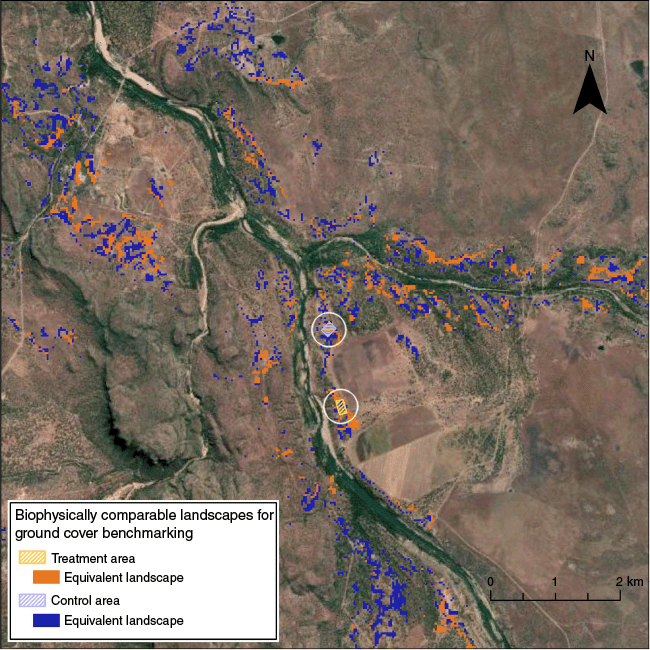
The final equivalence area was determined by applying all similarity criteria together by using a Boolean conjunction. To demonstrate application of the method, Fig. 7 shows the biophysically comparable landscapes for the Glen Bowen control and treatment sites. The Compere framework analysis was coded in Python because of its complexity, with additional plots and statistical analysis performed in R (R Core Team 2024).
Results
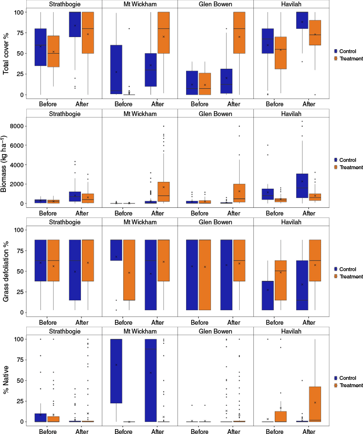
The before and after treatment field data for the control and treatment plots at each study site are shown graphically in Fig. 8 and the statistical results in Table 9, noting that results are presented on the basis of the 95% confidence level. There were significant improvements in cover and biomass that can be attributed to the treatments at both the Mount Wickham and Glen Bowen sites, generally within 1–2 years of treatment (P < 0.001); however, both sites had extremely low baseline levels at the initiation of the study. There were no statistically significant effects (improvements) in the % defoliation data that could be attributed to the treatment at any site, suggesting that grazing, as the main cause of vegetation removal, is not significantly different at the treatment sites compared to the control sites. Both Mount Wickham (P = 0.045) and Strathbogie (P = 0.001) demonstrated a statistically significant improvement in the proportion of native species at the treatment site that can be attributed to the management intervention. However, at Strathbogie, this change is considered more an artefact of improvements at the control site rather than treatment effects, and by 2023, the proportion of native species had reduced to pre-treatment levels in the treatment plot (Fig. 9d). Changes in each of the vegetation attributes over time are shown in Figs 9–15 and more detailed description of the results from each site are given below. The annual rainfall pattern, relative to the rehabilitation timing, is shown in Figs 10a, 12a, 14a, 16a.
Hillslope vegetation metrics for each site before and after treatment, in order from the top (i) percentage total standing groundcover, (ii) plant biomass or yield (kg ha–1), (iii) grass defoliation (a surrogate for grazing pressure) and (iv) proportion of native biomass (%). The x-values represent the mean value, the horizontal black line the median, the black vertical bars represent the values outside the 25th and 75th percentile range and the black dots are outliers.
Strathbogie control and treatment sites over the data collection period, with the vertical dashed red line showing when the treatment was applied, for (a) mean % ground cover, (b) mean biomass (kg ha−1), (c) mean defoliation (surrogate for vegetation removal) and (d) the proportion of native and non-native plant species. All data were collected before the wet season (generally Oct–Dec). Where included, error bars represent one standard deviation below and above the mean. P-values represent the significance of the interaction between intervention (treatment and control) and timing (pre-/post-treatment). Red text indicates significant difference but in favour of the control site (so no treatment effect). Orange represents a statistical difference, but this is largely a statistical artefact.
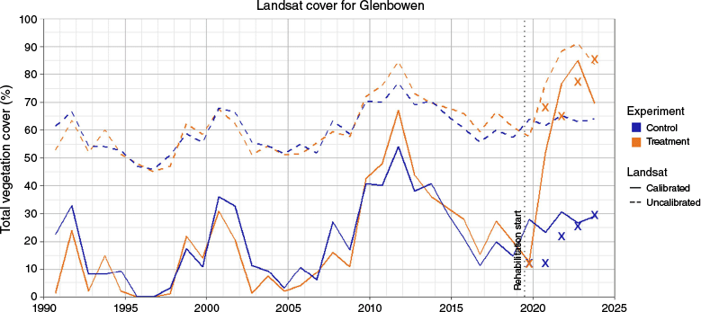
(a) Annual rainfall at Strathbogie from 1990 to 2023, showing the timing of the treatment and long-term average rainfall, (b) Total vegetation % cover at Strathbogie from 1990 to 2023, by using the Compere benchmark method. (c) The historical difference in cover at Strathbogie control and treatment relative to the local median cover represented by the horizontal dashed line. The timing of the rehabilitation is shown by the vertical dashed line. Post-rehabilitation treatment is not significantly (P = 0.440) improved relative to the control.
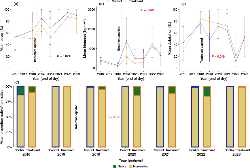
Mount Wickham control and treatment sites over the data collection period, with the vertical dashed red line showing when the treatment was applied, for (a) mean % ground cover, (b) mean biomass (kg ha−1), (c) mean defoliation (surrogate for vegetation removal) and (d) the proportion of native and non-native plant species. All data were collected before the wet season (generally Oct–Dec). Where included, error bars represent one standard deviation below and above the mean. P-values represent the significance of the interaction between intervention (treatment and control) and timing (pre-/post-treatment). Green text denotes significant difference that can be linked to the treatment effects.
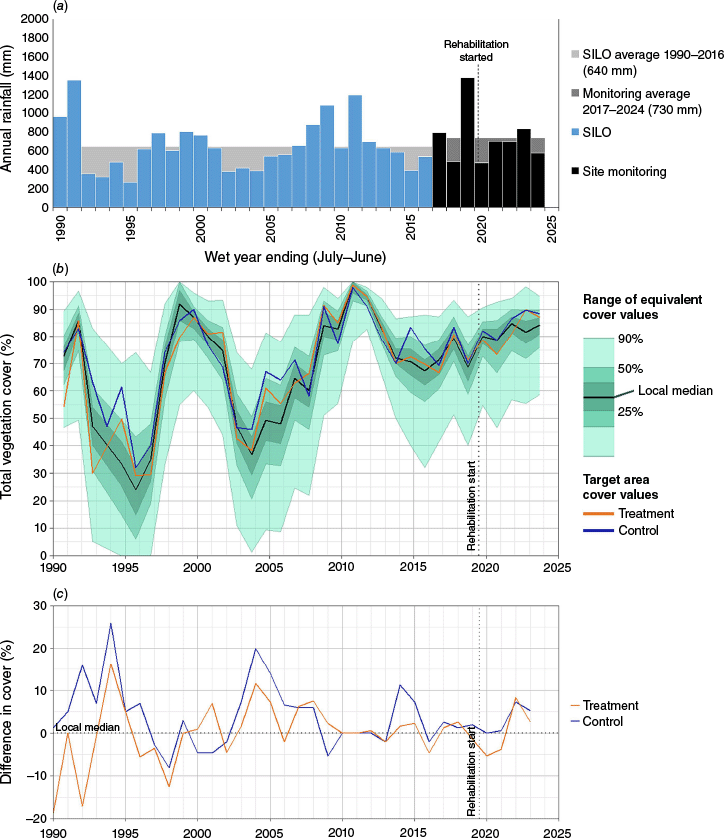
(a) Annual rainfall at Mount Wickham from 1990 to 2023, showing the timing of the treatment and long-term average rainfall. (b) Total vegetation % cover at Mount Wickham from 1990 to 2023, by using the Compere benchmark method. (c) The historical difference in cover at Mount Wickham control and treatment relative to the local median cover represented by the horizontal dashed line. The timing of the rehabilitation is shown in the vertical dashed line. Post-rehabilitation treatment has significantly (P < 0.001) improved relative to the control.
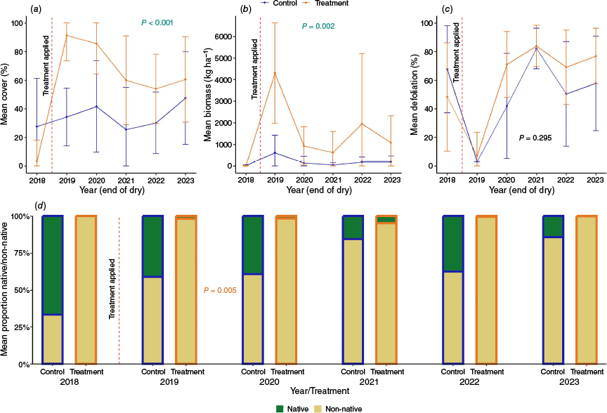
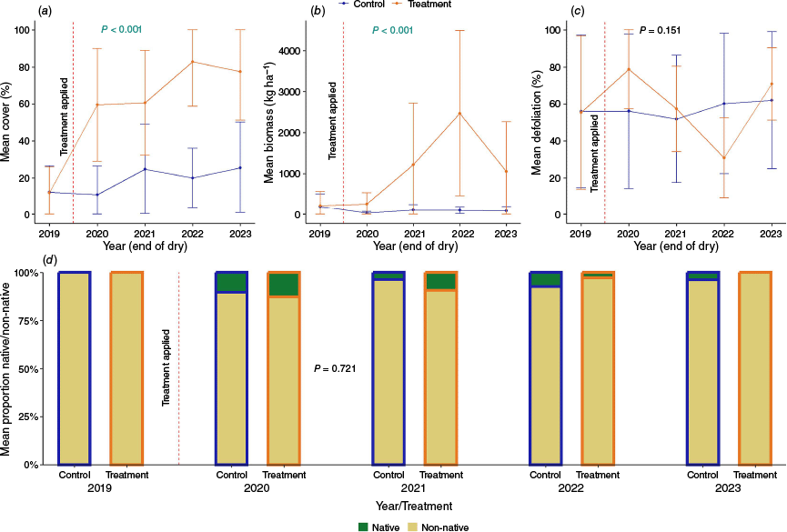
Glen Bowen control and treatment sites over the data collection period, with the vertical dashed red line showing when the treatment was applied, for (a) mean % ground cover, (b) mean biomass (kg ha−1), (c) mean defoliation (surrogate for vegetation removal) and (d) the proportion of native and non-native plant species. All data were collected before the wet season (generally Oct–Dec). Where included, error bars represent one standard deviation below and above the mean. P-values represent the significance of the interaction between intervention (treatment and control) and timing (pre-/post-treatment). Green text denotes significant difference that can be linked to the treatment effects.
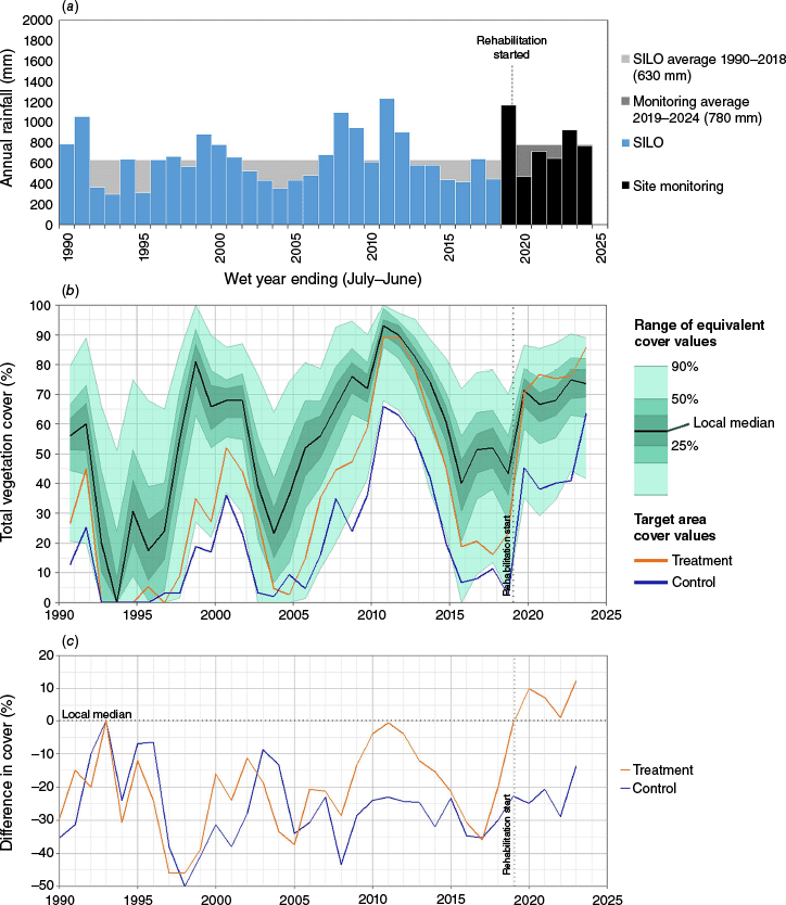
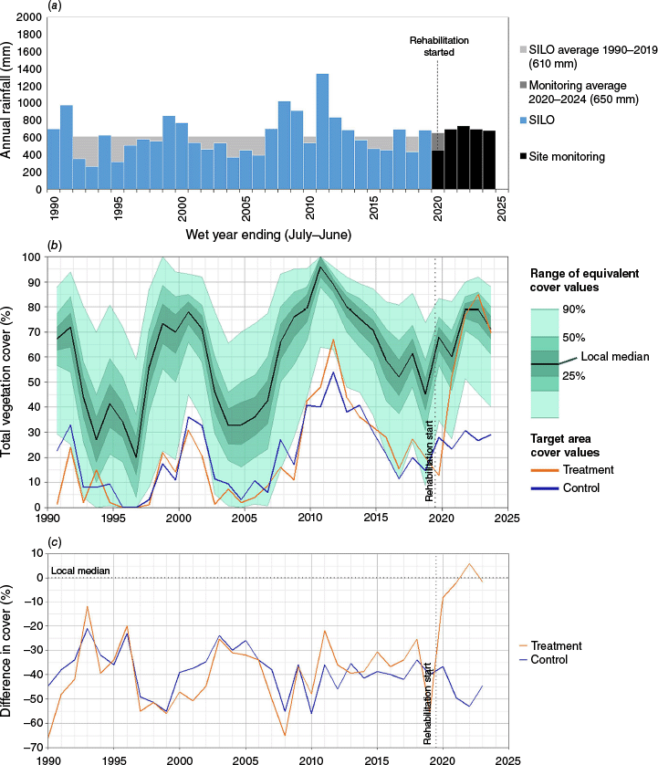
(a) Annual rainfall at Glen Bowen from 1990 to 2023, showing the timing of the treatment and long-term average rainfall. (b) Total vegetation % cover at Glen Bowen from 1990 to 2023, by using the Compere benchmark method, and (c) the historical difference in cover at Glen Bowen control and treatment relative to the local median cover represented by the horizontal dashed line. The timing of the rehabilitation is shown by the vertical dashed line. Post-rehabilitation treatment has significantly (P < 0.001) improved relative to the control.
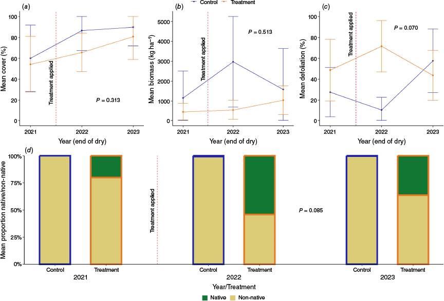
Havilah control and treatment sites over the data collection period, with the vertical dashed red line showing when the treatment was applied, for (a) mean % ground cover, (b) mean biomass (kg ha−1), (c) mean defoliation (surrogate for vegetation removal) and (d) the proportion of native and non-native plant species. All data were collected before the wet season (generally Oct–Dec). P-values represent the significance of the interaction between intervention (treatment and control) and timing (pre-/post-treatment).
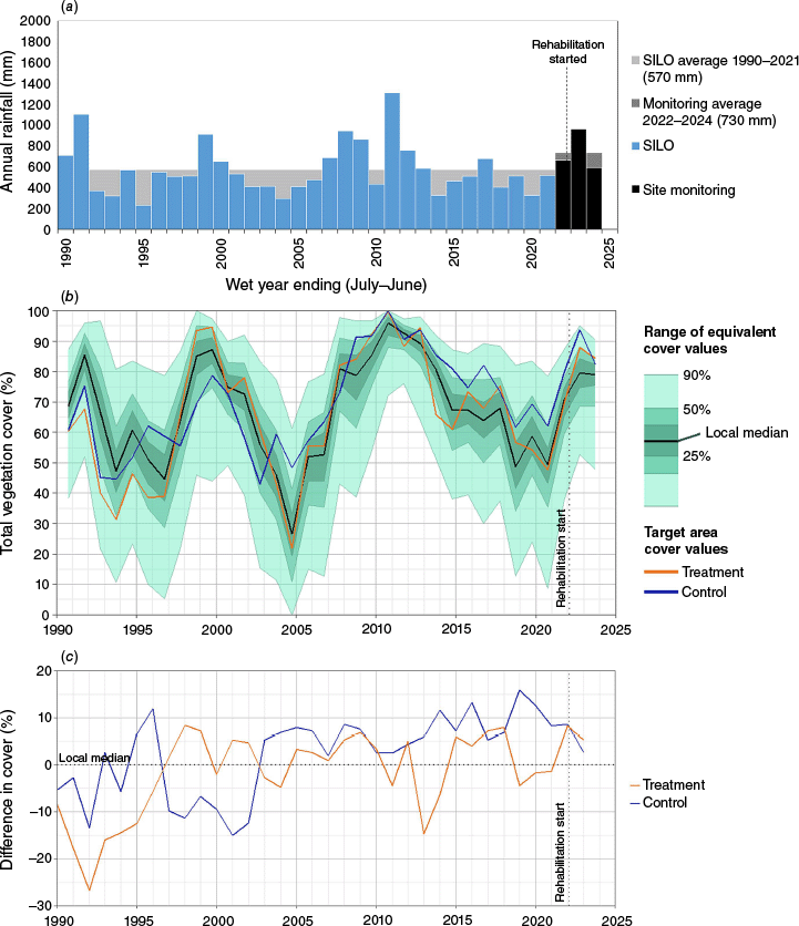
(a) Annual rainfall at Havilah from 1990 to 2023, showing the timing of the treatment and long-term average rainfall. (b) Total vegetation %cover at Havilah from 1990 to 2023, by using the Compere benchmark method and (c) the historical difference in cover at Havilah control and treatment relative to the local median cover represented by the horizontal dashed line. The timing of the rehabilitation is shown by the vertical dashed line. Post-rehabilitation treatment suggests that there is a significant (P < 0.001) improvement relative to the control; however, this was not supported by the on-ground data, and the length of the data set is likely to be too short for robust results.
| Remote sensing | Field Surveys | |||||||
|---|---|---|---|---|---|---|---|---|
| Site | Effect | %ground cover | %ground cover | Biomass (kg ha–1) | Defoliation (%) | %native | ||
| Strathbogie | Intervention (control vs treatment) | P < 0.001 | P = 0.003 | P = 0.205 | P = 0.007 | P = 0.616 | ||
| Timing (before and after) | P < 0.001 | P = 0.028 | P < 0.001 | P < 0.001 | P < 0.001 | |||
| Interaction (change owing to treatment) | P = 0.440 | P = 0.071 | P = 0.004 | P = 0.016 | P = 0.001 | |||
| Years to positive change | – | – | – | – | ||||
| Mount Wickham | Intervention (control vs treatment) | P < 0.001 | P < 0.001 | P < 0.001 | P = 0.178 | P < 0.001 | ||
| Timing (before and after) | P < 0.001 | P < 0.001 | P < 0.001 | P < 0.001 | P < 0.001 | |||
| Interaction (change owing to treatment) | P < 0.001 | P < 0.001 | P = 0.002 | P = 0.295 | P = 0.005 | |||
| Years to positive change | 1 year after treatment | 1 year after treatment | – | – | ||||
| Glen Bowen | Intervention (control vs treatment) | P < 0.001 | P < 0.001 | P < 0.001 | P < 0.001 | P = 0.165 | ||
| Timing (before and after) | P < 0.001 | P < 0.001 | P < 0.001 | P = 0.001 | P < 0.001 | |||
| Interaction (change owing to treatment) | P < 0.001 | P < 0.001 | P < 0.001 | P = 0.151 | P = 0.721 | |||
| Years to positive change | 1 year | 2 years after treatment | – | – | ||||
| Havilah | Intervention (control vs treatment) | P < 0.001 | P < 0.001 | P < 0.001 | P < 0.001 | P < 0.001 | ||
| Timing (before and after) | P < 0.001 | P < 0.001 | P = 0.030 | P = 0.031 | P = 0.340 | |||
| Interaction (change owing to treatment) | P < 0.001 | P = 0.313 | P = 0.513 | P = 0.070 | P = 0.085 | |||
| Years to positive change | – | – | – | – | ||||
Green (and italicised) text denotes significant difference that can be linked to the treatment effects. Red is significantly different but in favour of the control site (so no treatment effect). Orange represents a statistical difference, that represents a statistical artefact, which is usually owing to change in the control rather than an improvement in the treatment. Bold text represents the overall change, accounting for both treatment and timing effects.
To put the shorter-term field measured % cover data into a longer-term perspective, the remotely sensed (ground-calibrated Landsat) % cover data are also presented for each site. It is important to highlight that the local median cover level derived using the Compere method may not be an aspirational level of cover, and instead simply represents the condition of comparable properties in the local area.
Strathbogie
The Strathbogie site was the least costly of the three active treatment options and underwent moderate rehabilitation interventions in the form of hillslope flow diversion banks, pasture renovation (ripping), small rock revetment and permanent fencing for stock management. There have been positive, but not statistically significant, improvements in overall % cover at both control and treatment sites; however, biomass and defoliation were both higher and lower at the control site respectively (Fig. 9, Table 9). The improvements in the proportion of native species in the early years post-treatment, although significant, have not been sustained relative to the control sites by the final year of measurement in 2023 (Fig. 9d). The defoliation (which is a surrogate for grazing pressure) was significantly (P < 0.001) different between years before treatment began (between 2016 and 2018), suggesting that grazing intensity varied considerably between sites on this property, regardless of controlled management.
The remote-sensing analysis demonstrated how vegetation % cover broadly follows the annual rainfall pattern with higher % cover in ~2000 and ~2010, when there was a run of above-average rainfall years (Fig. 10a, b). Fig. 10b demonstrates that local sites (e.g. on black soil with similar slopes) had a similar ground cover response pattern to that of rainfall. Given Strathbogie follows the median line and tracks within the 25th and 50th cover percentiles, it is typical, if not slightly above average, when compared with similar sites in the local area. The remote-sensing data confirms that the control site has typically had higher cover than the treatment site from ~1990 until ~2007 (Fig. 10b, c). Interestingly, during the period between 1990 and 2000, the treatment plot had particularly low cover compared with the control site (Fig. 10b, c). This may be an example where higher than average rainfall (e.g. 1990, see Fig. 10a) encourages managers to increase stocking rates, or can stimulate preferential overgrazing by cattle in some areas and forage types (McKeon et al. 2009). When rainfall declines, this can lead to rapid reductions in ground cover if stocking rates are not rapidly adjusted (McKeon et al. 2004). From ~2000, both the treatment and control sites had similar cover levels.
The general pattern of increasing % cover post-treatment captured in the on-ground measured data (Fig. 9a) was also captured in the remote-sensing data (Fig. 10b). Interestingly, the subtle improvements in % cover at both the control and treatment sites are following the local median trend (Fig. 10b), bringing the property only marginally above the local % cover median (Fig. 10c). The absolute cover values were similar between the on-ground measured and remotely sensed data, with both control and treatment sites sitting at ~90% in 2023. Statistical analysis of pre- and post-remote-sensing % cover data gave similar (non-significant) results to those of the on-ground measurements in terms of the change caused by treatment effects (Table 9).
Mount Wickham
The Mount Wickham site was the longest running of the sites involving major earth works and included soil treatment (with gypsum), several rock chute structures, and considerable revegetation of the hillslope above the gully by using a seed mix of exotic pasture species and some native canopy species. It was also fenced for stock management. Prior to rehabilitation, both the control and treatment plot were largely void of vegetation, and that, combined with above average wet-season rain in 2019, resulted in significantly greater ground cover and biomass within 1 year of the treatment (Table 9, Fig. 11). Although the overall biomass at the Mount Wickham treatment site was significantly higher in the treatment than in the control (P = 0.002; Table 9), the biomass levels have declined since the first treatment year, demonstrating that this response is fragile and appears highly dependent on local annual rainfall (Figs 11b, 12a). The defoliation was very low at both sites in 2019, representing complete stock exclusion in this first year of treatment, and although there was no statistical difference in the mean defoliation between sites post-treatment (P = 0.295), defoliation rates (a surrogate for grazing) increased considerably at both sites from 2020 to 2023 (Fig. 11c). The increase in grazing pressure at the treatment site suggests potential co-benefits for grazing productivity, but this may be at the risk of further erosion. Given that the seed mix applied at the treatment plot contained only exotic pasture species, with natives being restricted to canopy species, it is not surprising that the treatment site continues to be dominated by the exotic grasses and legumes introduced during the rehabilitation process. In contrast, the control site retains higher proportions of native species (Fig. 11d). This highlights that, even though native species have increased marginally post-treatment, this was not the result of the revegetation strategy and has not resulted in a significant increase in the proportion of natives at the treatment site. The largest impact observed at the treatment site appears to be an explosion of exotic legumes, which has shadowed any increases in native biomass.
The remote-sensing data show that both the Mount Wickham sites have had persistently lower total vegetation % cover (with exception of a wet period c. 2010) since c. 1995 (Fig. 12b, c). The remote-sensing data were able to capture the rather dramatic improvements in % cover at the Mount Wickham treatment site following rehabilitation, in c. 2019 (Fig. 12b, c). The treatment site is now above the local median for similar sites in the region. The control site remains in the lower 10th–25th percentile of ground cover relative to the local median.
According to the ground-based % cover measurements, the treatment site in 2023 had ~60% cover, and the control ~45% (Fig. 11a). The remote-sensing data for the same year suggested that % cover was ~90% and 65% for the treatment and control sites, respectively. Even after calibration, the remote-sensing data are still potentially over-predicting the amount of cover on the ground. At the Mount Wickham site, this is likely to be a consequence of having more shrubs than at the other sites, with Carissa bush and woody legumes increasing the data spread for the site calibration. So, although the patterns of change between the measured and remotely sensed data are similar (Table 9), the absolute values are not.
Glen Bowen
The Glen Bowen site underwent major earth works in late 2019 that included soil treatment, rock chute structures and an earth bund. Significant re-vegetation used an exotic species grass seed mix. A permanent three-barbed fence for stock management, and a pipeline and off-site waterpoints were also installed. The Glen Bowen site was slightly different from the other sites because both the control and treatment surfaces were large alluvial gully features, and not hillslopes per se. The gully had eroded considerably and consumed the previous hillslope surface. Therefore, prior to rehabilitation, both the control and treatment plot were represented by gravelly dissected surfaces void of vegetation (see Fig. 4). The rainfall pattern at Glen Bowen was slightly different from that at Mount Wickham and the first-year post rehabilitation received below-average rainfall (see Fig. 14a). So, although both the cover and biomass were significantly higher (P < 0.001; Fig. 13a, b) at the treatment than at the control, the biomass took ~2 years to respond, suggesting that moisture and rainfall pattern are likely to influence vegetation recovery (Table 9, Fig. 13a, b). Also, at Glen Bowen, the post-treatment biomass data are significantly (P < 0.001) higher than pre-treatment biomass; however, by 2023 the biomass levels had fallen to ~1000 kg ha–1 and were no longer significantly greater than they were pre-treatment. This is also reflected in the defoliation data (Fig. 13c), suggesting that grazing (a combination of feral deer and cattle) is still occurring at the treatment site. Treatment led to no improvement in the % native plant species (P = 0.721; Fig. 13d), and therefore there are no vegetation biodiversity co-benefits from this site.
Similar to Mount Wickham, the remote-sensing data for Glen Bowen suggest that % cover has been persistently very low relative to the local median or equivalent sites in the region (Fig. 14b, c). Again, there were some obvious trends in % cover responses to rainfall, but the cover at both the control and treatment sites at Glen Bowen was between 10% and ~60% lower than the local median since 1990 (Fig. 14c), with overall cover dropping to near zero for several periods (Fig. 12b). The remote-sensing data were able to capture the dramatic improvements in % cover at the Glen Bowen treatment site following rehabilitation. These data also demonstrated that the improvement was slower than at Mount Wickham, which is probably a consequence of below-average rainfall years immediately after treatment (Fig. 12a–c). The treatment site was above the local median for similar sites in the region; however, increased defoliation (Fig. 13c) has now brought this site back in line with the local median for this land type. The control site continues to track well below the local median (Fig. 12b, c). The absolute % cover values are similar between the two methods and align well at the end of the measurement period in 2023, with the treatment site being estimated at ~80% and control site at ~20% by using both techniques (Figs 13a, 14b).
Havilah
Havilah is the most recent of the rehabilitation sites, undergoing major earth works in late 2021 that included soil treatment, several rock chute structures, re-vegetation by using a mixed exotic species seed mix, and a permanent fence for stock management. However, the vegetation plots here are more reflective of the grazing management at the property than the engineering treatment per se. There had only been 2 years of post-treatment data from this site, compared with 5 years for Strathbogie and Mount Wickham, and there were no significant differences between any of the measurement attributes (Table 9). In fact, the control plot had higher cover and biomass post-treatment (Fig. 15a, b). Despite estimated reduced grazing pressure (Table 4), the defoliation rates at the property were also similar post-treatment, suggesting that grazing management has not changed significantly since pre-treatment at either the control or treatment site. The mean proportion of native grass species has increased at the treatment plot in the 2 years since this project began, although this change is not quite significant (P = 0.085) because there was already a higher proportion of natives at the treatment site prior to the intervention (Fig. 15d).
The remote-sensing data demonstrated that Havilah is the only site where both the control and treatment plots have broadly tracked within the 25th to 50th bands of the local median cover value since 1990 (Fig. 16b, c). There are too few measurement years to make any meaningful conclusions from the post-treatment data at Havilah; however, this site demonstrates that it will be a lot harder to identify statistically significant changes from sites that have already been tracking at or close to the local median %ground cover.
The absolute values in terms of on-ground measured % cover and remotely sensed % cover align well at the end of the measurement period in 2023, with % cover being estimated at ~80–85% for both the control and treatment sites by using both methods (Figs 15, 16). However, the remote-sensing analysis suggests that the difference between the control and treatment is statistically significant (P < 0.001) when the on-ground measurements suggest that there is no difference (P = 0.313). This may be an example of where site idiosyncrasies in soil reflectance and/or short data periods are giving different results between the remotely sensed and ground-measured data. Potentially it demonstrates that on-ground data, on their own, are less powerful, particularly over shorter time frames.
Discussion
Key findings from this study
This study has presented the results for the rehabilitation of ground cover on four paired (control and treatment) sites in the Burdekin catchment. A total of ~A$2.5 million in rehabilitation funding was spent across the four properties, indicating the size and significance of the investments. We acknowledge that this study is far from the perfect sampling design; however, these are not dedicated long-term research sites. These sites represent ‘typical’ rehabilitation projects and provide rich insights into the process and outcomes that occur on working cattle stations in climatically variable rangeland environments.
Synthesising the findings from the four study sites has shown a complex picture of vegetation rehabilitation outcomes, with varying degrees of success. At Strathbogie, the results indicated modest but inconsistent improvements. Although both control and treatment plots showed positive trends in vegetation cover, these were not statistically significant. Biomass was higher and defoliation lower at the control site, suggesting limited treatment impact. The only notable co-benefit was increased biomass at the control site, potentially enhancing beef production (as a co-benefit). In contrast, Mount Wickham results demonstrated more pronounced and statistically significant improvements in vegetation cover and biomass following treatment. However, these gains had diminished by 2023, underscoring the need for sustained grazing management to maintain soil health and vegetation productivity. Interestingly, although the treatment site showed increased grazing potential, this was not reflected in the proportion of native species, likely owing to the dominance of introduced exotic grasses and legumes. The failure of native vegetation establishment, possibly because of a severe post-treatment rainfall event, further limited biodiversity outcomes. Glen Bowen also experienced strong positive responses in cover and biomass attributable to treatment, although these responses were slower, likely because of lower post-treatment rainfall. Grazing pressure, as indicated by defoliation rates, was higher on the treatment site by 2023, suggesting potential productivity benefits. However, the absence of native species on the treatment plot in 2023 indicated no vegetation biodiversity co-benefits. Finally, the Havilah site, which lacked mechanical intervention and relied solely on grazing management, showed no significant changes in any of the vegetation attributes.
Remote sensing effectively captured general trends at all sites, but tended to overestimate absolute cover values, likely owing to the presence of woody legumes, highlighting the need for cautious interpretation. Remote sensing is also unable to capture subtle changes, and on-ground monitoring is necessary to evaluate the impacts of grazing management on attributes such as species diversity. It is also acknowledged that although rainfall is a major driver of vegetation response, fertiliser application, the addition of organic matter, and nitrogen mineralisation triggered by soil disturbance are likely to have played a role in promoting early biomass increases, particularly at Glen Bowen and Mount Wickham. At the only site that used native seed (Mount Wickham), no native species were identified to have established in response to the rehabilitation. Any changes to native plant biodiversity that was detected in this study often involved legumes and smaller native forbs that are common in these landscapes. Challenges with the sampling design notwithstanding, the results suggest that the rehabilitation provided no enhancements for threatened or rare species. In summary, although some sites showed promising short-term gains in vegetation cover and biomass, these improvements were often fragile. The findings emphasise the importance of long-term management and monitoring, particularly in relation to grazing pressure.
Integration of the results from this study with the broader literature
There are numerous papers outlining the high-level strategic ‘golden’ rules for restoring various ecosystems (e.g. see Gann et al. 2019; Di Sacco et al. 2021; Quigley et al. 2022), and readers are encouraged to consider those papers. This study identified many similar, but also some unique, issues specifically related to restoring degraded rangeland areas. On the basis of the results of this study, as well as drawing from the published literature, we have seven suggestions or considerations for those undertaking future rehabilitation projects in degraded rangeland environments, and they are listed below. Very few of the principles outlined are new. The novelty lies in the validation data provided through these case studies, and in the integration of key principles to guide future programs, hopefully enabling more rapid progress towards sustainable outcomes than previously achieved.
1. Detecting vegetation change on rangeland rehabilitation sites is challenging, so pack your patience: data need to be evaluated against natural rainfall variability and an untreated control, and even then, it may take decades
As eloquently demonstrated by Macintosh et al. (2024) evaluating change or improvements in vegetative forest cover can be challenging against the ever-fluctuating natural variability in rangelands. The same issue applies to vegetative ground or grass cover. Therefore, to detect improvements in vegetative ground cover from rehabilitation or management change requires evaluation against (a) vegetation growth resulting from natural rainfall variability and (b) an un-treated control. Where possible, these data should also be assessed using long-term (or the longest available) cover data from the site. Including these elements in a study will help avoid detecting false improvements from rehabilitation. For example, if the Strathbogie treatment site were assessed as an independent site, without comparing to a control and regional median sites, it could be falsely concluded that cover was improving as a result of the treatment, when this is not the case. As outlined by Lindenmayer et al. (2022), monitoring programs should have appropriate experimental designs, that consider seasonal and annual variation.
This study also identified that detecting improvements in cover is likely to be proportional to the baseline condition. That is, unless sites are severely disturbed, detecting change will be hard and may take a long time. For example, Bartley et al. (2022) determined that it is likely to take 15–20 years for statistically significant improvements in ground cover to be measurable at some sites, particularly for areas that are moving from a moderately degraded baseline pasture condition. Detecting improvements in cover at the Havilah (pasture) site may take decades, given that this site is not necessarily significantly degraded relative to the local median condition. The Mount Wickham and Glen Bowen sites demonstrated that detecting statistical improvements will generally be quicker and easier when the sites are severely disturbed at the initiation of the treatment.
2. Remote sensing is useful, but there is no silver bullet for monitoring change and one metric will rarely tell the whole story
This study confirmed that remote-sensing data, when calibrated using ground-based measurements, are a good proxy or representation of change in ground cover over time. However, when data are un-calibrated, cover can be grossly over-predicted (as demonstrated in Fig. 6). When looking for significant differences, the significance values could be quite different between the ground-based measurements and remote-sensing methods. It is possible that these differences are attributable to a lack of statistical power in the ground-based measurement data, but they are more likely to be attributable to a range of issues with the remote-sensing data, including scale, edge effects, tree cover and calibration issues (Scarth et al. 2008; Bartley et al. 2022). As outlined in Stokes et al. (2023), ground cover is often not a good representation of biomass yields over time, and despite improvements in biomass prediction from remote sensing (Chen et al. 2021), caution is required when using remote sensing to track rehabilitation success.
3. Active rehabilitation is likely to demonstrate changes much more quickly than GLM on its own, but it will be very costly, and long-term maintenance will be required
This study demonstrated that statistical improvements in ground cover and biomass could be achieved in relatively short time frames (1–2 years), but where statistical improvements were detected, considerable resources were invested (>A$500,000) to achieve this outcome. In some of these extremely degraded sites (e.g. Mount Wickham and Glen Bowen), the rehabilitation may mean halting or avoiding further decline but may not lead to net improvement beyond the local baseline condition. This was best demonstrated at Glen Bowen, where the cover in 2023 was equivalent to the local median on-ground % cover; it did not exceed the local baseline. This has implications for concepts such ‘additionality’ (Macintosh et al. 2024), and ‘Nature Positive’ (https://www.naturepositive.org/), which hope to achieve net positive improvements over time.
Grazing on fragile sodic alluvial soils is likely to be one of the many drivers of severe erosion (Wilkinson et al. 2018; Stokes et al. 2023). Therefore, careful management of grazing is critical for maintaining these sites into the future and preventing additional erosion. Higher vegetation biomass levels will need to be maintained on-site (rather than exported off-site by cattle) to increase soil nutrients, including soil carbon. In some cases, tipping points and thresholds may have been surpassed, or new species have colonised, so recovery may need to be evaluated against new baseline conditions (Stokes et al. 2023). Irrespective of the rehabilitation approach, all sites will require long-term maintenance to ensure the benefits persist, and landholder agreements should be put in place to support this process. This needs to be factored into the overall costs of the treatment.
4. Who benefits from the rehabilitation? Aligning ‘production’ and environmental outcomes will be challenging
The over-arching goal of the rehabilitation needs to be clearly defined and communicated at the beginning of the study, noting that there will always be trade-offs, and both biophysical and social indicators should be considered (Klaus 2023). We acknowledge the challenges associated with engaging landholders (Pannell et al. 2006) and part of the engagement process (or ‘gate openers’) often requires the promise of economic ‘production’ gains following the rehabilitation process. It is not that biomass productivity and environmental co-benefits cannot co-exist, but in these climatically variable rangelands of northern Australia, it is a fragile balance. Runting et al. (2024) suggested that environmental outcomes could be improved for northern Australia tropical savannas by stocking below modelled carrying capacity and implementing fire management. Sites where severe erosion has occurred and has been treated, should not be returned to previous levels of grazing; there is too much risk. Even with low grazing densities, a few poor wet seasons may unravel the rehabilitation and re-incise the landscape triggering further erosion.
It is also arguable that for at least the first 5 years post-treatment, sites that have had had >A$500,000 of investment from Government funding should have complete stock exclusion. On the basis of the defoliation data presented in this study, this is not occurring. In most cases, the land had very low production benefit prior to treatment, and following treatment it should not be expected to be integrated into standard paddock rotations and become an economically viable part of the property. These areas will always remain fragile owing to their soil and landscape attributes. It is acknowledged that the sites may need some occasional grazing to support fire and weed management; however, in the long-term, these sites need to be managed as an environmental asset and should not necessarily be ‘returned’ to pre-treatment grazing management practices. How and who pays for this maintenance is an active area of discussion (Sutton et al. 2016; Bond et al. 2024) and the evidence base for the natural capital outcomes associated with differing grazing management practices is incomplete (O’Grady et al. 2024).
5. If you want to capture biodiversity co-benefits, think strategically about the selection of revegetation species in the planning phase, and consider co-benefits at whole of property scales
The initial objective of the rehabilitation in this study was erosion control. However, with the increase in environmental markets, Australia’s Nature Positive Plan (DCCEEW 2022), and the Land Restoration Fund (https://www.qld.gov.au/environment/climate/climate-change/land-restoration-fund), there is an increasing interest in combining or ‘stacking’ environmental benefits (Baumber et al. 2019). However, very few studies have measured multiple benefits at a site. This is because there are often large differences in the spatial scale at which the various co-benefits can be achieved. These gully sites are too small to be suitable for carbon co-benefits, and it is acknowledged that the biodiversity outcomes from small gully-scale interventions are likely to be limited. Incorporating biodiversity goals also introduces additional challenges and cost pressures for erosion control.
The focus for the sites in this study was on establishing ground cover as quickly as possible, and native seed mix was used only at one site (see Supplementary Material S1). Natives may not always be the most appropriate species for rapid ground cover establishment; however, the post-treatment ‘production’ lens may have also biased the re-vegetation species selected to focus on non-native palatable pasture species. This study has highlighted that if biodiversity co-benefits are to be considered, this needs to occur early in the design process to ensure that appropriate re-vegetation strategies and species are employed. In some instances, co-benefits may be best managed at the property scale rather than at the individual site level. For example, native vegetation, either from seed or tube stock, might be planted adjacent to, rather than directly within, the most severely degraded areas. This approach allows for the potential natural colonisation of remediation sites by native species from the surrounding landscape.
Regardless of the location of the native vegetation, successful seedling recruitment is known to be episodic and rare, particularly for tropical savanna eucalypt species (Fensham 1992; Williams 2009). It is also acknowledged that native seed can be hard to source, with seed from only 12% of Australian plant species available for immediate purchase (Andres et al. 2024). Revegetation success is often more dependent on climatic and site factors, regardless of revegetation method (Greet et al. 2020); however, combining tubestock and direct seeding techniques may provide insurance in years where environmental conditions are not conducive to seedling establishment. Using tubestock will likely come with additional expense and maintenance (e.g. watering) should markedly increase the ecological and carbon benefits for the site, improve soil nutrient availability (Jackson and Ash 2001) and provide other benefits such as shade for cattle (England et al. 2020). Vegetation monitoring methods deployed will also need to be adapted to capture biodiversity co-benefits into the future. Caution is also required in terms of the mix and diversity of species that are supported on these rehabilitation sites, because legume dominance has been associated with soil acidification, nutrient depletion and increased soil erosion (Noble et al. 2000).
6. Linking vegetation rehabilitation to changes in runoff downstream: we need to scale up
Re-vegetation, particularly using trees and woody species, is known to decrease streamflow in areas downstream (Luo et al. 2020; Hoek van Dijke et al. 2022). In some areas, this can be problematic, but in the catchments draining to the GBR, this has been an aspiration to help reduce runoff and erosion reaching downstream ecosystems (Bainbridge et al. 2018). An accompanying paper to this study is evaluating the effects of these rehabilitation treatments on runoff and sediment yield (A. A. Hawdon, R. Bartley, A. Kinsey-Henderson, S. N. Wilkinson, J. Marano, K. Mitchell, B. N. Abbott, J. Morris, B. Murray, unpubl. data); however, because of the multiple treatment activities that have occurred at each site, it will be difficult to attribute the specific role vegetation has had on any changes to runoff. Nonetheless, research published elsewhere has demonstrated that grassland rehabilitation, supported by considerable reductions in livestock numbers, has the potential to reduce runoff downstream, by ~15–20%, primarily because of the increased evapotranspiration and soil water retention associated with increased grass cover (Li et al. 2017). Reductions in runoff will likely also reduce erosion, and the ability for sediment (and seeds) to be transported downstream. However, the size of the area restored will have an influence on the time frames for runoff reduction. Given that the areas being treated and actively managed in the GBR are relatively small, and given that livestock numbers have not reduced in the GBR catchments (Lewis et al. 2021), it is unlikely that rehabilitation effects will be detected in downstream ecosystems for decades (Darnell et al. 2012).
7. Not all areas can or should be restored: select sites carefully and knowledge is power
Rehabilitation is expensive. The rehabilitation economy is growing, and can be considered an important activity in economic terms for many nations (BenDor et al. 2015). Despite notably large funding investments in some areas (e.g. investments into improving water quality in the catchments draining to the Reef; Waterhouse et al. (2024a), there will never be sufficient resources to restore all degraded areas and ecosystems (Wintle et al. 2019). A meta-analysis study by Jones et al. (2018) found that ecosystems rarely recover completely, and often active rehabilitation did not result in faster or more complete recovery than simply ending the disturbances that ecosystems face. Because of the time frames it can take for ecosystems and landscapes to recover, and the associated R&D investment required to support the monitoring of these changes, there is little quantitative evidence available on the costs and benefits of undertaking cheaper actions such as fencing off and stock removal from degraded areas, versus the need for active engineering. The Havilah site represents an example of a study site that would be amenable to longer- term monitoring of grazing management only.
This study has demonstrated that in the short term, active and expensive interventions do get responses quickly. Because of the long recovery timescales associated with disturbance, and the large range of responses within the same ecosystem types (Jones and Schmitz 2009), there is limited evidence to determine where and what type of treatments should be used for different levels of degradation. However, this study has demonstrated that using long-term remote-sensing data, which spans ~40 years, can be useful for identifying areas that are persistently below local medians, and that may require more active intervention. The concept of triaging hot-spots and using such data as an early warning system is not new (McKeon et al. 2004), but it may be an under-utilised tool to help triage locations for rehabilitation at the subcatchment and individual-property level. Considering recommendation Number 6 above, the connectivity of sites targeted for rehabilitation will be important for supporting ecological and water quality co-benefits. This is much discussed in protected area management (Beger et al. 2022), but is rarely considered in agricultural landscapes when managing erosion, because it is associated with the variable aspirations and world views of landholders. It is the increased and improved knowledge of all landholders that will support landscape repair in rangelands more broadly (McKeon et al. 2004). This will become increasingly important as climate change intensifies both the magnitude and frequency of runoff events, as well as the duration of dry periods (Wasko et al. 2024).
Conclusions
This study has provided insights into the opportunities and challenges associated with restoring degraded eroding rangeland areas draining to the Great Barrier Reef. On the basis of this study, several areas of research were identified that would help support the rehabilitation economy into the future. These include (i) the need for monitoring and evaluation data from eroded sites that are fenced off and treated with low-cost soil amelioration and revegetation, and/or fenced off only with no active treatment; the timescales and outcomes from these treatments would help improve decisions about where and what rehabilitation is required, hopefully with reduced costs; (ii) additional knowledge or trials on the mix and types of re-vegetation planting strategies to support both grass and woody cover re-establishment in highly degraded rangeland systems; this would help support biodiversity co-benefits and should consider the use of climate resilient species (Prober et al. 2019); and (iii) baseline data on additional attributes that may be suitable for environmental markets (e.g. soil carbon and woody carbon).
Data availability
Access to the data used in this study are available from the corresponding author upon reasonable request.
Declaration of funding
This paper was supported with funding from the Australian Government’s National Environmental Science Program Tropical Water Quality Hub (Projects 2.14 and 5.9), Queensland Government’s Landholders Driving Change Project, and the Great Barrier Reef Foundations Reef Trust Partnership. The projects were managed and supported by NQ Dry Tropics Regional Body. Photograph sources are as credited. We also thank the property owners for allowing access to their properties and their involvement in the projects. Thanks go to Darren Watts and Family (Strathbogie), Warren Woodhouse (Mount Wickham), Christian and Melissa Cormack (Glen Bowen) and to Bec and Shane Lathwell (Havilah Station). Their contributions are extremely valuable.
Acknowledgements
We also acknowledge the contributions from the contracting groups responsible for the design and on-ground works. These include Verterra, Alluvium, Neilly Group and CoalField Services (Shane Watts), and to many others that provided support and insights to these projects including John Day, Barb Colls, Glenn Dale, Rod Kerr and Mark McConnell. Ideas in this paper were generated from conversations with many people over many years. These include but are not limited to Scott Wilkinson, Peter Hairsine, Scott Crawford, Christian Roth, Andrew Ash and Damon Telfer. We also acknowledge the helpful review comments from Suzanne Prober, Randall Donohue, Christian Roth, two anonymous reviewers and the journal editors.
Author contributions
Rebecca Bartley designed the project, managed the contracts and project milestones for the first 5 years of funding, completed the statistical analysis of the field data and drafted the paper. Brett Abbott was responsible for the design, collection, statistical analysis and presentation of the hillslope vegetation data and undertook the remote-sensing analysis for all sites, and contributed to writing. Bruce Murray supported the collection and analysis of the field data and produced the R Stats graphics, and contributed to stats analysis and writing. Anne Henderson collated rainfall data and prepared the site maps. Aaron Hawdon was involved in site selection and management the managed the contracts and project milestones for the final 3 years of funding.
References
Andres SE, Atkinson J, Coleman D, Brazill-Boast J, Wright IJ, Allen S, Gallagher RV (2024) Constraints of commercially available seed diversity in restoration: implications for plant functional diversity. Plants, People, Planet 6, 1341-1357.
| Crossref | Google Scholar |
Ash AJ, Corfield JP, McIvor JG, Ksiksi TS (2011) Grazing management in tropical savannas: utilization and rest strategies to manipulate rangeland condition. Rangeland Ecology & Management 64(3), 223-239.
| Crossref | Google Scholar |
Bainbridge Z, Lewis S, Bartley R, Fabricius K, Collier C, Waterhouse J, Garzon-Garcia A, Robson B, Burton J, Wenger A, Brodie J (2018) Fine sediment and particulate organic matter: a review and case study on ridge-to-reef transport, transformations, fates, and impacts on marine ecosystems. Marine Pollution Bulletin 135, 1205-1220.
| Crossref | Google Scholar | PubMed |
Bainbridge Z, Olley J, Wilkinson S, Bartley R, Lewis S, Dougall C, Khan S, Kuhnert P, Burton J (2023) Refining fine sediment source identification through integration of spatial modelling, concentration monitoring and source tracing: a case study in the Great Barrier Reef catchments. Science of The Total Environment 892, 164731.
| Crossref | Google Scholar | PubMed |
Bartley R, Roth CH, Ludwig J, McJannet D, Liedloff A, Corfield J, Hawdon A, Abbott B (2006) Runoff and erosion from Australia’s tropical semi-arid rangelands: influence of ground cover for differing space and time scales. Hydrological Processes 20(15), 3317-3333.
| Crossref | Google Scholar |
Bartley R, Croke J, Bainbridge ZT, Austin JM, Kuhnert PM (2015) Combining contemporary and long-term erosion rates to target erosion hot-spots in the Great Barrier Reef, Australia. Anthropocene 10, 1-12.
| Crossref | Google Scholar |
Bartley R, Poesen J, Wilkinson S, Vanmaercke M (2020) A review of the magnitude and response times for sediment yield reductions following the rehabilitation of gullied landscapes. Earth Surface Processes and Landforms 45, 3250-3279.
| Crossref | Google Scholar |
Bartley R, Abbott BN, Ghahramani A, Ali A, Kerr R, Roth CH, Kinsey-Henderson A (2022) Do regenerative grazing management practices improve vegetation and soil health in grazed rangelands? Preliminary insights from a space-for-time study in the Great Barrier Reef catchments, Australia. The Rangeland Journal 44(4), 221-246.
| Crossref | Google Scholar |
Bastin GN, Pickup G, Stanes J, Stanes A (1996) Estimating landscape resilience from satellite data and its application to pastoral land management. The Rangeland Journal 18(1), 118-135.
| Crossref | Google Scholar |
Bastin G, Cowley R, Friedel M, Materne C (2023) Applying two remotely-sensed methods for monitoring grazing impacts in the Australian arid zone. The Rangeland Journal 45(4), 141-159.
| Crossref | Google Scholar |
Baumber A, Metternicht G, Cross R, Ruoso L-E, Cowie AL, Waters C (2019) Promoting co-benefits of carbon farming in Oceania: applying and adapting approaches and metrics from existing market-based schemes. Ecosystem Services 39, 100982.
| Crossref | Google Scholar |
Beger M, Metaxas A, Balbar AC, McGowan JA, Daigle R, Kuempel CD, Treml EA, Possingham HP (2022) Demystifying ecological connectivity for actionable spatial conservation planning. Trends in Ecology & Evolution 37(12), 1079-1091.
| Crossref | Google Scholar | PubMed |
BenDor T, Lester TW, Livengood A, Davis A, Yonavjak L (2015) Estimating the size and impact of the ecological restoration economy. PLoS One 10(6), e0128339.
| Crossref | Google Scholar | PubMed |
Beutel TS, Graz FP (2023) Can we benchmark annual ground cover maintenance? The Rangeland Journal 44(6), 333-342.
| Crossref | Google Scholar |
Bond AJ, O’Connor PJ, Cavagnaro TR (2024) Carbonservation with demonstrated biodiversity and carbon gains: carbon can pay but biodiversity must lead. Environmental Management 73(4), 742-752.
| Crossref | Google Scholar | PubMed |
Charmley E, Thomas D, Bishop-Hurley GJ (2023) Revisiting tropical pasture intake: what has changed in 50 years? Animal Production Science 63(18), 1851-1865.
| Crossref | Google Scholar |
Chen Y, Guerschman J, Shendryk Y, Henry D, Harrison MT (2021) Estimating pasture biomass using Sentinel-2 imagery and machine learning. Remote Sensing 13(4), 603.
| Crossref | Google Scholar |
Christensen RHB (2018) Cumulative link models for ordinal regression with the R package ordinal. Journal of Statistical Software 35, 1-46.
| Google Scholar |
Darnell R, Henderson B, Kroon FJ, Kuhnert P (2012) Statistical power of detecting trends in total suspended sediment loads to the Great Barrier Reef. Marine Pollution Bulletin 65(4–9), 203-209.
| Crossref | Google Scholar | PubMed |
DCCEEW (2022) ‘Nature Positive Plan: better for the environment, better for business’. CC BY 4.0. (Department of Climate Change, Energy, the Environment and Water: Canberra, ACT, Australia) Available at https://www.dcceew.gov.au/sites/default/files/documents/nature-positive-plan.pdf
Di Sacco A, Hardwick KA, Blakesley D, Brancalion PHS, Breman E, Cecilio Rebola L, Chomba S, Dixon K, Elliott S, Ruyonga G, Shaw K, Smith P, Smith RJ, Antonelli A (2021) Ten golden rules for reforestation to optimize carbon sequestration, biodiversity recovery and livelihood benefits. Global Change Biology 27(7), 1328-1348.
| Crossref | Google Scholar | PubMed |
Donohue RJ, Mokany K, McVicar TR, O’Grady AP (2022) Identifying management-driven dynamics in vegetation cover: applying the Compere framework to Cooper Creek, Australia. Ecosphere 13(3), e4006.
| Crossref | Google Scholar |
Donohue R, Leys J, Howorth J, Henderson A, Abbott B, Chen Y (2023) ‘Monitoring management-driven changes in total vegetation cover. A methods report for the National Landcare Program.’ csiro:EP2023-2374. (CSIRO: Canberra, ACT, Australia) 10.25919/d0sc-mj33.
Doriean NJC, Bennett WW, Spencer JR, Garzon-Garcia A, Burton JM, Teasdale PR, Welsh DT, Brooks AP (2021) Intensive landscape-scale remediation improves water quality of an alluvial gully located in a Great Barrier Reef catchment. Hydrology and Earth System Sciences 25(2), 867-883.
| Crossref | Google Scholar |
Dumbrell NP, Robinson CJ, Ricketts KD, Urzedo D, Walker L, Bond AJ (2024) Toward land restoration transitions: elevating regional voices and the provenance of co-benefits in Queensland rangelands. The Rangeland Journal 46(1), RJ23045.
| Crossref | Google Scholar |
Dybala KE, Steger K, Walsh RG, Smart DR, Gardali T, Seavy NE (2019) Optimizing carbon storage and biodiversity co-benefits in reforested riparian zones. Journal of Applied Ecology 56(2), 343-353.
| Crossref | Google Scholar |
England JR, O’Grady AP, Fleming A, Marais Z, Mendham D (2020) Trees on farms to support natural capital: an evidence-based review for grazed dairy systems. Science of The Total Environment 704, 135345.
| Crossref | Google Scholar | PubMed |
Fensham RJ (1992) The establishment of eucalypt seedlings in tropical savanna forest. Northern Territory Naturalist 13, 30-36.
| Crossref | Google Scholar |
Fleming A, Stitzlein C, Jakku E, Fielke S (2019) Missed opportunity? Framing actions around co-benefits for carbon mitigation in Australian agriculture. Land Use Policy 85, 230-238.
| Crossref | Google Scholar |
Frankl A, Nyssen J, Vanmaercke M, Poesen J (2021) Gully prevention and control: techniques, failures and effectiveness. Earth Surface Processes and Landforms 46(1), 220-238.
| Crossref | Google Scholar |
Gann GD, McDonald T, Walder B, Aronson J, Nelson CR, Jonson J, Hallett JG, Eisenberg C, Guariguata MR, Liu J, Hua F, Echeverría C, Gonzales E, Shaw N, Decleer K, Dixon KW (2019) International principles and standards for the practice of ecological restoration. Second edition. Restoration Ecology 27(S1), S1-S46.
| Crossref | Google Scholar |
Geoscience Australia (2022) ‘DEA Water Observations.’ (Geoscience Australia: Canberra, ACT, Australia) 10.26186/146257
Godde CM, Boone RB, Ash AJ, Waha K, Sloat LL, Thornton PK, Herrero M (2020) Global rangeland production systems and livelihoods at threat under climate change and variability. Environmental Research Letters 15(4), 044021.
| Crossref | Google Scholar |
Greet J, Ede F, Robertson D, McKendrick S (2020) Should I plant or should I sow? Restoration outcomes compared across seven riparian revegetation projects. Ecological Management & Restoration 21(1), 58-65.
| Crossref | Google Scholar |
Guerschman JP, Hill MJ (2018) Calibration and validation of the Australian fractional cover product for MODIS collection 6. Remote Sensing Letters 9(7), 696-705.
| Crossref | Google Scholar |
Hall TJ, McIvor JG, Reid DJ, Jones P, MacLeod ND, McDonald CK, Smith DR (2014) A comparison of stocking methods for beef production in northern Australia: pasture and soil surface condition responses. The Rangeland Journal 36(2), 161-174.
| Crossref | Google Scholar |
Hoek van Dijke AJ, Herold M, Mallick K, Benedict I, Machwitz M, Schlerf M, Pranindita A, Theeuwen JJE, Bastin J-F, Teuling AJ (2022) Shifts in regional water availability due to global tree restoration. Nature Geoscience 15(5), 363-368.
| Crossref | Google Scholar |
Jackson J, Ash AJ (2001) The role of trees in enhancing soil nutrient availability for native perennial grasses in open eucalypt woodlands of north-east Queensland. Australian Journal of Agricultural Research 52(3), 377-386.
| Crossref | Google Scholar |
Jones HP, Schmitz OJ (2009) Rapid recovery of damaged ecosystems. PLoS One 4(5), 5653.
| Crossref | Google Scholar | PubMed |
Jones HP, Jones PC, Barbier EB, Blackburn RC, Rey Benayas JM, Holl KD, McCrackin M, Meli P, Montoya D, Mateos DM (2018) Restoration and repair of Earth’s damaged ecosystems. Proceedings of the Royal Society B. Biological Sciences 285(1873), 20172577.
| Crossref | Google Scholar | PubMed |
Khan S, Bartley R, Kinsey-Henderson A, Hawdon A (2024) Assessing gully erosion and rehabilitation using multi temporal LiDAR DEMs: case study from the Great Barrier Reef catchments, Australia. International Soil and Water Conservation Research 12(1), 184-199.
| Crossref | Google Scholar |
Klaus VH (2023) Pitfalls in global grassland restoration challenge restoration programs and the science–policy dialogue. Ecological Indicators 149, 110185.
| Crossref | Google Scholar |
Koci J, Wilkinson SN, Hawdon AA, Kinsey-Henderson AE, Bartley R, Goodwin NR (2021) Rehabilitation effects on gully sediment yields and vegetation in a savanna rangeland. Earth Surface Processes and Landforms 46(5), 1007-1025.
| Crossref | Google Scholar |
Kroon FJ, Schaffelke B, Bartley R (2014) Informing policy to protect coastal coral reefs: insight from a global review of reducing agricultural pollution to coastal ecosystems. Marine Pollution Bulletin 85(1), 33-41.
| Crossref | Google Scholar | PubMed |
Lewis SE, Bartley R, Wilkinson SN, Bainbridge ZT, Henderson AE, James CS, Irvine SA, Brodie JE (2021) Land use change in the river basins of the Great Barrier Reef, 1860 to 2019: a foundation for understanding environmental history across the catchment to reef continuum. Marine Pollution Bulletin 166, 112193.
| Crossref | Google Scholar | PubMed |
Li J, Liu D, Wang T, Li Y, Wang S, Yang Y, Wang X, Guo H, Peng S, Ding J, Shen M, Wang L (2017) Grassland restoration reduces water yield in the headstream region of Yangtze River. Scientific Reports 7(1), 2162.
| Crossref | Google Scholar | PubMed |
Liao Z, Van Dijk AIJM, He B, Larraondo PR, Scarth PF (2020) Woody vegetation cover, height and biomass at 25-m resolution across Australia derived from multiple site, airborne and satellite observations. International Journal of Applied Earth Observation and Geoinformation 93, 102209.
| Crossref | Google Scholar |
Lindenmayer DB, Woinarski J, Legge S, Maron M, Garnett ST, Lavery T, Dielenberg J, Wintle BA (2022) Eight things you should never do in a monitoring program: an Australian perspective. Environmental Monitoring and Assessment 194(10), 701.
| Crossref | Google Scholar | PubMed |
Luo YY, Yang YT, Yang DW, Zhang SL (2020) Quantifying the impact of vegetation changes on global terrestrial runoff using the Budyko framework. Journal of Hydrology 590, 125389.
| Crossref | Google Scholar |
Lymburner L (2021) ‘Geoscience Australia Landsat Fractional Cover Collection 3.’ (Canberra, ACT, Australia) Available at https://pid.geoscience.gov.au/dataset/ga/145498
Macintosh A, Evans MC, Butler D, Larraondo P, Edirisinghe C, Hunter KB, Evans MJ, Ansell D, Waschka M, Lindenmayer D (2024) Non-compliance and under-performance in Australian human-induced regeneration projects. The Rangeland Journal 46, RJ24024.
| Crossref | Google Scholar |
Mappin B, Ward A, Hughes L, Watson JEM, Cosier P, Possingham HP (2022) The costs and benefits of restoring a continent’s terrestrial ecosystems. Journal of Applied Ecology 59(2), 408-419.
| Crossref | Google Scholar |
Mariotti A, Croke J, Bartley R, Kelley SE, Ward J, Fülöp R-H, Rood AH, Rood DH, Codilean AT, Wilcken K, Fifield K (2021) Pre-development denudation rates for the Great Barrier Reef catchments derived using 10Be. Marine Pollution Bulletin 172, 112731.
| Crossref | Google Scholar | PubMed |
Marschner I (2011) glm2: Fitting generalized linear models with convergence problems. The R Journal 3, 12-15.
| Google Scholar |
McCloskey GL, Baheerathan R, Dougall C, Ellis R, Bennett FR, Waters D, Darr S, Fentie B, Hateley LR, Askildsen M (2021) Modelled estimates of fine sediment and particulate nutrients delivered from the Great Barrier Reef catchments. Marine Pollution Bulletin 165, 112163.
| Crossref | Google Scholar | PubMed |
McKeon GM, Stone GS, Syktus JI, Carter JO, Flood NR, Ahrens DG, Bruget DN, Chilcott CR, Cobon DH, Cowley RA, Crimp SJ, Fraser GW, Howden SM, Johnston PW, Ryan JG, Stokes CJ, Day KA (2009) Climate change impacts on northern Australian rangeland livestock carrying capacity: a review of issues. The Rangeland Journal 31(1), 1-29.
| Crossref | Google Scholar |
McLennan S, McLean I, Paton, C (2020) Re-defining the animal unit equivalence (AE) for grazing ruminants and its application for determining forage intake, with particular relevance to the northern Australian grazing industries: Meat and Livestock Australia Ltd. Report Number B.GBP.0036. Available at https://www.mla.com.au/contentassets/5f3a4bcdfbd243a9a19e80cfbb84d2c7/b.gbp.0036_final_report.pdf .
Melland AR, Fenton O, Jordan P (2018) Effects of agricultural land management changes on surface water quality: a review of meso-scale catchment research. Environmental Science & Policy 84, 19-25.
| Google Scholar |
Noble AD, Orr DM, Middleton CH, Rogers LG (2000) Legumes in native pasture: asset or liability? A case history with stylo. Tropical Grasslands 34(3/4), 199-206.
| Google Scholar |
O’Grady AP, Mendham DS, Mokany K, Smith GS, Stewart SB, Harrison MT (2024) Grazing systems and natural capital: influence of grazing management on natural capital in extensive livestock production systems. Nature-Based Solutions 6, 100181.
| Crossref | Google Scholar |
Olley J, Brooks A, Spencer J, Pietsch T, Borombovits D (2013) Subsoil erosion dominates the supply of fine sediment to rivers draining into Princess Charlotte Bay, Australia. Journal of Environmental Radioactivity 124(0), 121-129.
| Crossref | Google Scholar | PubMed |
O’Reagain PJ, Turner JR (1992) An evaluation of the empirical basis for grazing management recommendations for rangeland in southern Africa. Journal of the Grassland Society of Southern Africa 9(1), 38-49.
| Crossref | Google Scholar |
Orr DM, O’Reagain PJ (2011) Managing for rainfall variability: impacts of grazing strategies on perennial grass dynamics in a dry tropical savanna. Rangeland Journal 33(2), 209-220.
| Crossref | Google Scholar |
Pannell DJ, Marshall GR, Barr N, Curtis A, Vanclay F, Wilkinson R (2006) Understanding and promoting adoption of conservation practices by rural landholders. Australian Journal of Experimental Agriculture 46(11), 1407-1424.
| Crossref | Google Scholar |
Pedersen T (2024) patchwork: The Composer of Plots. R package version 1.3.0. Available at https://CRAN.R-project.org/package=patchwork
Prober SM, Doerr VAJ, Broadhurst LM, Williams KJ, Dickson F (2019) Shifting the conservation paradigm: a synthesis of options for renovating nature under climate change. Ecological Monographs 89(1), e01333.
| Crossref | Google Scholar |
Quigley KM, Hein M, Suggett DJ (2022) Translating the 10 golden rules of reforestation for coral reef restoration. Conservation Biology 36(4), e13890.
| Crossref | Google Scholar | PubMed |
R Core Team (2024) ‘R: a language and environment for statistical computing.’ Version 4.4.0. (R Foundation for Statistical Computing: Vienna, Austria) Available at https://www.R-project.org/
Runting RK, King D, Nolan M, Navarro Garcia J, Marcos-Martinez R, Rhodes JR, Gao L, Watson I, Ash A, Reside AE, Álvarez-Romero JG, Wells JA, Ritchie EG, Hadjikakou M, Driscoll DA, Connor JD, Garber J, Bryan BA (2024) Balancing livestock production and environmental outcomes in northern Australia’s tropical savanna under global change. Environmental Research Letters 19(10), 104014.
| Crossref | Google Scholar |
Stokes C, Bartley R, Abbott BN, Hawdon AA, Kinsey-Henderson AE (2023) Long-term monitoring and modelling of pasture regeneration and water quality from a Bothriochloa pertusa site in the Great Barrier Reef catchments. The Rangeland Journal 45(1), 12-26.
| Crossref | Google Scholar |
Sutton PC, Anderson SJ, Costanza R, Kubiszewski I (2016) The ecological economics of land degradation: impacts on ecosystem service values. Ecological Economics 129, 182-192.
| Crossref | Google Scholar |
Tothill J, Hargreaves J, Jones R, McDonald C (1992) BOTANAL – a comprehensive sampling and computing procedure for estimating pasture yield and composition. 1. Field sampling. Tropical Agronomy Technical Memorandum 78, 1-22.
| Google Scholar |
Underwood A (1994) On beyond BACI: sampling designs that might reliably detect environmental disturbances. Ecological Applications 4(1), 3-15.
| Crossref | Google Scholar |
Viscarra Rossel R, Chen C, Grundy M, Searle R, Clifford D, Odgers N, Holmes K, Griffin T, Liddicoat C, Kidd D (2014a) ‘Soil and Landscape Grid National Soil Attribute Maps – Effective Cation Exchange Capacity (3″ resolution). Release 1. v5. Data Collection.’ (CSIRO) 10.4225/08/546F091C11777
Viscarra Rossel R, Chen C, Grundy M, Searle R, Odgers N, Holmes K, Griffin T, Liddicoat C, Kidd D, Cliffors D (2014b) ‘Soil and Landscape Grid National Soil Attribute Maps - Clay (3″ resolution). Release 1. v7. Data Collection.’ (CSIRO) 10.4225/08/546EEE35164BF
Waltham NJ, Elliott M, Lee SY, Lovelock C, Duarte CM, Buelow C, Simenstad C, Nagelkerken I, Claassens L, Wen CK-C, Barletta M, Connolly RM, Gillies C, Mitsch WJ, Ogburn MB, Purandare J, Possingham H, Sheaves M (2020) UN decade on ecosystem restoration 2021–2030. What chance for success in restoring coastal ecosystems? Frontiers in Marine Science 7, 71.
| Crossref | Google Scholar |
Wasko C, Stephens C, Peterson TJ, Nathan R, Pepler A, Hettiarachchi S, Vogel E, Johnson F, Westra S (2024) Understanding the implications of climate change for Australia’s surface water resources: challenges and future directions. Journal of Hydrology 645, 132221.
| Crossref | Google Scholar |
Waterhouse J, Pineda M-C, Sambrook K, Newlands M, McKenzie L, Davis A, Pearson R, Fabricius K, Lewis S, Uthicke S, Bainbridge Z, Collier C, Adame F, Prosser I, Wilkinson S, Bartley R, Brooks A, Robson B, Diaz-Pulido G, Reyes C, Caballes C, Burford M, Thorburn P, Weber T, Waltham N, Star M, Negri A, Warne MSJ, Templeman S, Silburn M, Chariton A, Coggan A, Murray-Prior R, Schultz T, Espinoza T, Burns C, Gordon I, Devlin M (2024a) 2022 Scientific Consensus Statement: Conclusions. In ‘2022 Scientific Consensus Statement on land-based impacts on Great Barrier Reef water quality and ecosystem condition’. (Eds J Waterhouse, M-C Pineda, K Sambrook) (Commonwealth of Australia and Queensland Government)
Waterhouse J, Pineda M-C, Sambrook K, Newlands M, McKenzie L, Davis A, Pearson R, Fabricius K, Lewis S, Uthicke S, Bainbridge Z, Collier C, Adame F, Prosser I, Wilkinson S, Bartley R, Brooks A, Robson B, Diaz-Pulido G, Reyes C, Caballes C, Burford M, Thorburn P, Weber T, Waltham N, Star M, Negri A, Warne MSJ, Templeman S, Silburn M, Chariton A, Coggan A, Murray-Prior R, Schultz T, Espinoza T, Burns C, Gordon I, Devlin M (2024b) 2022 Scientific Consensus Statement: Summary. In ‘2022 Scientific Consensus Statement on land-based impacts on Great Barrier Reef water quality and ecosystem condition’. (Eds J Waterhouse, M-C Pineda, K Sambrook) (Commonwealth of Australia and Queensland Government)
Wickham H (2016) ‘ggplot2: Elegant Graphics for Data Analysis.’ (Springer-Verlag: New York, NY, USA) Available at https://ggplot2.tidyverse.org.
Wickham H, François R, Henry L, Müller K, Vaughan D (2023) dplyr: A Grammar of Data Manipulation. R package version 1.1.4. Available at https://CRAN.R-project.org/package=dplyr.
Wilfred J, Searle R, Thomas M, Grundy M (2014) Soil and Landscape Grid National Soil Attribute Maps – Depth of Regolith (3″ resolution). Release 2.’ (CSIRO: Canberra, ACT, Australia) Available at https://data.csiro.au/collection/csiro:11393
Wilkinson SN, Hancock GJ, Bartley R, Hawdon AA, Keen R (2013) Using sediment tracing to assess processes and spatial patterns of erosion in grazed rangelands, Burdekin River basin, Queensland, Australia. Agriculture, Ecosystems and Environment 180, 90-102.
| Crossref | Google Scholar |
Wilkinson SN, Dougall C, Kinsey-Henderson AE, Searle RD, Ellis RJ, Bartley R (2014) Development of a time-stepping sediment budget model for assessing land use impacts in large river basins. Science of The Total Environment 468-469, 1210-1224.
| Crossref | Google Scholar | PubMed |
Wilkinson SN, Kinsey-Henderson AE, Hawdon AA, Hairsine PB, Bartley R, Baker B (2018) Grazing impacts on gully dynamics indicate approaches for gully erosion control in northeast Australia. Earth Surface Processes and Landforms 43(8), 1711-1725.
| Crossref | Google Scholar |
Williams PR (2009) Contrasting demographics of tropical savanna and temperate forest eucalypts provide insight into how savannas and forests function. A case study using Corymbia clarksoniana from north-eastern Australia. Austral Ecology 34(2), 120-131.
| Crossref | Google Scholar |
Wintle BA, Cadenhead NCR, Morgain RA, Legge SM, Bekessy SA, Cantele M, Possingham HP, Watson JEM, Maron M, Keith DA, Garnett ST, Woinarski JCZ, Lindenmayer DB (2019) Spending to save: what will it cost to halt Australia’s extinction crisis? Conservation Letters 12(6), e12682.
| Crossref | Google Scholar |
Zerga B (2015) Rangeland degradation and restoration: a global perspective. Point Journal of Agriculture and Biotechnology Research 1(2), 037-054:.
| Google Scholar |