

Phosphorus status and saturation in soils that drain into the Peel Inlet and Harvey Estuary of Western Australia
David Weaver A C and Robert Summers B
A Department of Primary Industries and Regional Development, Western Australia, 444 Albany Highway, Albany, WA 6330, Australia.
B Department of Primary Industries and Regional Development, Western Australia, 45 Mandurah Tce, Mandurah, WA 6210, Australia.
C Corresponding author. Email: david.weaver@dpird.wa.gov.au
Soil Research 59(7) 699-714 https://doi.org/10.1071/SR20259
Submitted: 7 September 2020 Accepted: 22 March 2021 Published: 23 June 2021
Journal Compilation © CSIRO 2021 Open Access CC BY
Abstract
The Peel–Harvey estuarine system in Western Australia's south-west is affected by poor water quality, algal blooms, and fish kills. Phosphorus (P) discharge from agricultural activities is the main source of poor water quality. The catchment’s soils are naturally infertile, but P application has increased P fertility. This paper draws on and undertakes a meta-analysis of 20 200 surface (0–10 cm) and profile (to 100 cm depth) soil samples collected in the period 1983–2018. Soil P content was high, with 70% of samples with Colwell P content in excess of agronomic requirements; Production is more likely limited by low soil pH(CaCl2) and low K (92% and 67% of paddocks respectively). Strong P stratification in the soil is evident, particularly topsoil; sandy soils are saturated to depth; and clay soils show signs of P saturation in the topsoil. Management of P in sandy soil near the estuary is a high priority as is P stratification in highly P retentive soil. Soil P stocks increased since clearing compared with uncleared soils (1221 kg ha–1 m–1 and 285–694 kg ha–1 m–1, respectively). Thirteen percent of samples had P content in excess of agronomic requirements in 1983, rising slowly to 69% in 2018. Landholder practices need to be analysed in detail to confirm if this accumulation occurs everywhere or is only confined to actively farmed land.
Keywords: eutrophication, P saturation, P management, P loss, P efficiency, water quality, Peel–Harvey, estuary health.
Introduction
Soils in south-west Western Australia (SWWA) were deficient in phosphorus (P) when land clearing for agriculture commenced in the 1800s. To overcome P deficiency, superphosphate application, particularly in the period 1945–1975 became an integral part of farming practice (Birch 1982; Yeates 1993) in the Peel–Harvey coastal catchment. An unintended consequence of P use in agriculture has been increased P loss to waterways, removing natural limitations to algal growth in the Peel Inlet and Harvey estuarine system (Kinhill Engineers 1988). As algae decompose, oxygen is depleted and fish kills occur (Hodgkin and Hamilton 1993). Of the coastal catchments in SWWA, the Peel–Harvey coastal catchment has the most P discharge (Ruprecht et al. 2013), with ~90% of the P sourced from ~210 000 ha of predominantly farmland in the coastal section of the catchment (Kinhill Engineers 1988).
Agricultural P loss has been widely reported (Sharpley and Withers 1994; Weaver and Reed 1998) and attributed to long-term P application to agricultural watersheds, leading to elevated soil P and widespread P losses from legacy P sources (Jarvie et al. 2013). The diffuse loss of this legacy soil P is one of the most difficult to control (Sims et al. 1998).
With time, repeated P application results in a gradual increase in P diffused into particles that have adsorbed P; this increases the negative charge of soil particles and subsequently reduces P buffering capacity of the soil (Barrow et al. 2018). Tian et al. (2019) identified that 31–65% of applied P was found to have accumulated in soil P stocks when measured over 57 years. They found that excessive P application and soil P accumulation beyond agronomic requirements resulted in a P use efficiency decrease of 57% and increased P losses of 33%.
Various measures of soil P saturation have been proposed, and are typically based on measures of available P divided by measures of P sorption capacity, or other indirect measures such as ammonium oxalate extractable iron (Ammox Fe) and aluminium (Ammox Al); or Mehlich P (Nair 2014). Strong positive relationships between measures of P saturation such as the Degree of Phosphorus Saturation (DPS) and P concentration in run-off have also been identified (Nair et al. 2004; Tarkalson and Mikkelsen 2004; Withers et al. 2017; Dari et al. 2018).
Knowledge of P source and transport factors (Sharpley et al. 2008), as well as the location of soil at risk of P loss allows targeting of ‘fit for purpose’ management practices and resources to optimise agricultural production whilst minimising water quality impacts. Conceptual models of transport pathways such as leaching through sandy soils, surface runoff from sandy soils when the water tables rise to the surface, and surface runoff from nutrient stratified clay soils is important to couple with knowledge of the spatial and vertical distribution of P storage, P retention and saturation in order to better understand P loss risk, and management interventions with potential to reduce P loss. For example, knowledge of soil P stratification (Ryan et al. 2017) and the extent of subsoil P retention capacity provides insight into the potential for P-rich surface soil to be displaced from run-off pathways by incorporation into the soil profile rather than being exposed to run-off when concentrated at the surface. In addition, knowledge of temporal trends can provide insight into the impacts of agricultural practice on stored soil P (McDowell et al. 2021), and the potential for legacy P drawdown to contribute to improved water quality (Rowe et al. 2016; Withers et al. 2017).
Much of the knowledge of soil P retention, saturation, spatial and vertical variability of P storage, and the associated risk of loss is often acquired through dedicated research programs with clear hypotheses aimed at answering specific questions. However, opportunities to reinforce and value-add to existing knowledge also lie in meta-analysis of less prescriptive, but often large datasets from soil testing programs, which at their core are designed to promote evidence-based fertiliser decisions, rather than test a specific hypothesis. For example, government sponsored soil testing in the Peel–Harvey catchment occurred from 1983 to 1991, followed by targeted topsoil and subsoil sampling in 2006. From 2009 to 2018, government soil testing programs aimed at supporting evidence-based fertiliser decisions recommenced.
The meta-analysis of disparate soil testing programs presented here allows questions on the stocks of P in the soils, the rate and magnitude of change of P reserves, where to target intervention and how P has built up within the soil profile to be explored. In addition, the data presents an opportunity to develop pedotransfer functions for P sorption measures, which have changed during the period of this dataset. Such a dataset also allows the spatial representation of parameters that provide insight into water quality risk (P sorption, saturation and content), enabling fit-for-purpose management decisions to be more targeted.
Material and methods
Catchment environment
The Peel–Harvey coastal catchment is part of the Swan Coastal Plain, Western Australia (Fig. 1a) and is predominantly characterised by infertile Aeolian dunal systems running parallel to the coast and a narrow band of fluvial clay soils along the eastern edge of the plain beside the Darling Scarp. The fluvial clay soils are a small proportion of the catchment and are derived from the river systems running off lateritic upland. The area’s Mediterranean climate with 3–4 months of winter rainfall (up to 900 mm) results in inundation, with run-off carrying P to the Peel–Harvey estuary (Hodgkin and Hamilton 1993). The area was first settled in the early 1830s but the nutrient deficiency problems of the sandy soils were not solved until trace elements and superphosphate were introduced in the 1940s. Subsequent P fertiliser subsidies resulted in landholders on the coastal plain applying superphosphate heavily, with rates commonly up to 600 kg ha–1. This coincided with further clearing and artificial drainage of the coastal areas in the 1940s and 1950s, and 75% of the area is now pasture for agriculture. Research in the 1970s and 1980s linked the loss of P to algal blooms and water quality problems in the estuarine system and efforts began to reduce excessive P application (DA Lord and Associates 1998).

|
Soils in the catchment are largely used to grow rain-fed subterranean clover and ryegrass pastures in a mixed sward for the purpose of grazing cattle (including dairy) and sheep. Although small areas of intensive agriculture (such as horticulture) exist, and urban development is increasing, extensive grazing activities occupy most of the landscape (Environmental Protection Authority 2008).
Soil sampling
Agricultural extension programs operated from 1983 to 1991 and from 2009 to 2018 in the Peel–Harvey coastal catchment, with the aim of providing landholders with evidence-based fertiliser recommendations based on soil sampling to 10 cm depth. In 2006, soil profiles representative of the area tested in 1983–1991 were sampled incrementally to 100 cm depth. The number of paddocks sampled and analytes tested varied each year depending on program resources and the soil testing methods prevailing at the time (Table 1). Analytical techniques are described below in chemical analysis.

|
1983–1991
Composite soil samples (0–10 cm) comprising 30 cores were taken using a 19 mm diameter sampler to represent each paddock. Samples were analysed for a standard set of agronomic soil tests, contemporary for the time including pH(CaCl2) (Rayment and Lyons 2011), Colwell P (Colwell 1965), Colwell K (Rayment and Lyons 2011), and ammonium oxalate extractable iron (Ammox Fe) (Tamm 1922). The analogue soil chemical data and sample locations from this period were digitised (Fig. 1b) for 15 334 samples.
2006
A total of 314 sites representative of the 1983–1991 period were revisited and resampled (0–10 cm) using the same soil sampling equipment and protocols. In addition, a mechanised direct-push core sampler was used to take soil samples in increments of 0–5, 5–10, 10–20, 20–40 and 40–100 cm. Samples were taken from one paddock per farm and geolocated (Fig. 1b). The analytical suite was expanded to include phosphorus retention index (PRI) (Allen and Jeffery 1990), phosphorus buffering index (PBI) (Burkitt et al. 2002) and total P (Rayment and Lyons 2011), whilst continuing with Ammox Al and Fe (Tamm 1922).
Soil in stands of remnant vegetation were also sampled at six locations in the Peel–Harvey coastal catchment but most of the uncleared land was representative only of sandy soil with PBI < 15. To supplement the soil samples in remnant vegetation with a PBI ≥ 15, a further 42 locations in stands of remnant vegetation were included from sampling programs on the south coast of WA.
2009–2018
Composite 0–10 cm samples (n = 2912) each comprising 30 cores of soil were taken and geolocated to represent each paddock (Fig. 1b). The analytical suite was further expanded to include KCl-40 S (Blair et al. 1991), which was measured from 2016 to 2018 (Table 1).
Soil preparation and analyses
Following sampling, soil samples were prepared by oven drying at 40°C, sieving <2 mm and mixing before analysis. Colwell P and Colwell K were determined after extracting soil with 0.5 M NaHCO3 at pH 8.5 for 16 h at 25°C at a soil solution ratio of 1:100 (Colwell 1965). Total P (TP) was determined after digestion in sulfuric acid in the presence of a Kjeldahl catalyst (Rayment and Lyons 2011). Phosphorus in extractions and digests was determined using the colourimetric procedure of Murphy and Riley (1962) and K was determined by atomic adsorption spectroscopy (Rayment and Lyons 2011). pH(CaCl2) was determined after extracting soil for 1 h with 0.01 M calcium chloride solution at a soil solution ratio of 1:5 (Rayment and Lyons 2011). Soil organic carbon (OC) was estimated using the heat of dilution method (Walkley and Black 1934).
Ammox Fe and Ammox Al were determined by absorption spectrophotometry after extracting soil for 1 h at a soil solution ratio of 1:33 with Tamm’s reagent (Tamm 1922; Blakemore et al. 1977). Phosphorus retention index was determined following incubation of soil with 10 mg P L–1 at 1:20 soil:solution ratio for 16 h (Allen and Jeffery 1990) and expressed as the ratio of the P sorbed to P remaining in solution. Phosphorus buffering index was determined by incubating soil with a 100 mg P L–1 at a 1:10 soil:solution ratio for 16 h and is corrected for Colwell P (Burkitt et al. 2002). Soil sulfur (S) was determined using the KCl-40 S method (Blair et al. 1991).
Pedotransfer functions
As each of the soil test measures were not in continuous use through the study period (Table 1), pedotransfer functions between various measures were developed using multiple linear regression (MLR) to provide a more complete spatial and temporal data series (Kleinman et al. 1999; Borggaard et al. 2004). Watmuff et al. (2013) propose pedotransfer functions to estimate PBI from other P sorption measures, however, sample sizes are often small for the proposed regressions, are often restricted to specific ranges of the independent variable, and do not include all of the analytes required here. For example, surrogate measures of P sorption using Ammox Fe and Al were used in the period 1983–1991, whilst single point P sorption measures such as PRI were used in the period 2006–2016, and PBI from 2006 to 2018 depending on procedures contemporary of the time. Prior to MLR, variables were log-transformed to remove skewness and approximate normal distributions (Helsel and Hirsch 1992). Transforms and MLR were prepared using DataDesk 8.2 (Data Description Inc.)
PBI was estimated from Ammox Fe using the function described by Weaver and Wong (2011). PRI was estimated from other soil variables using Eqn 1, 2 or 3, depending on which analytes were available in the timeseries.


Ammox Fe was estimated using Eqn 4.

Total P was estimated using Eqn 5 or 6.


Derived measures
P status
The response of pasture to applied P depends on soil P sorption and Colwell P (Ozanne and Shaw 1967; Moody 2007; Gourley et al. 2019). Critical Colwell P values used to achieve 90–95% of relative yield (RY) were used to classify soils as P sufficient or deficient.
Measures of P saturation
A P environmental risk index (PERI) was determined as the ratio of Colwell P to PBI (Eqn 7) and is analogous to DPS and the likelihood that soluble P can be leached from the soil (Moody 2011).

The molar P saturation ratio (DPS) (Sims et al. 2002; Nair et al. 2004; Nair 2014) was calculated using Eqn 8 or 9, depending on what analytes were available in the timeseries.


P fertility index
The P fertility index (Cope and Rouse 1973) is estimated as the ratio of measured Colwell P to the critical or target Colwell P (Eqn 10) to achieve 90 or 95% RY (Gourley et al. 2019). The index represents the proportional contribution made by the soil to meet pasture P demand in the absence of applied nutrient, assuming no other constraints. Index values near to 1 are agronomically optimal, values less than 1 are considered deficient, and values greater than 1 are considered in excess. The amount above or below index values of 1 indicates the degree of P sufficiency or deficiency.

Data analysis
Analytes and derived variables were presented depth wise as notched box and whisker plots (Aabel NG2, Gigawiz Ltd) (McGill et al. 1978) and as violin plots (Igor Pro ver. 8 WaveMetrics, Inc.) (Hintze and Nelson 1998). For box and whisker plots, notches represent an area that can be visually compared to another boxplot to explore differences between factors or treatments. McGill et al. (1978) explain that in the absence of a formal statistical test, when notches do not overlap, the median values are ‘approximately, significantly different’. Non-linear regression (Igor Pro ver. 8) and correlation (Spearman rank; DataDesk 8.2, Data Description Inc.) were used to identify relationships between different soil analytes and variables. Soil variables and those derived from pedotransfer functions for measures of TP, P95 fertility index, PBI, PRI, DPS and PERI were interpolated spatially using inverse distance weighting (ArcView 3.2 and Spatial Analyst, ESRI; QGIS 3.8, Creative Commons), and the correlation and regression between interpolated variables determined.
Results
The median Colwell P of the assembled data in the 0–10 cm topsoil was 31 mg kg–1 and 8 mg kg–1 in the 10–100 cm subsoil. Median TP values were 140 mg kg–1 in the 0–10 cm topsoil and 57 mg kg–1 in the 10–100 cm subsoil. The median Colwell K in the 0–10 cm topsoil was 70 mg kg–1 compared to 33 mg kg–1 in the 10–100 cm subsoil. Median KCl-40 S in the 0–10 cm topsoil was 9.5, whilst median soil pH(CaCl2) in the 0–10 cm topsoil was 4.4 compared to 4.5 in the 10–100 cm subsoil (Table 2). Median values of PRI were 12.6 in the 0–10 cm topsoil and 55.0 in the 10–100 cm subsoil, whilst PBI was 55.0 in the 0–10 cm topsoil and 20.1 in the 10–100 cm subsoil. Median soil OC was 3.2% in 0–10 cm topsoil and 1.1% in the 10–100 cm subsoil.

|
Many soil analytes and derived variables were strongly correlated (Table 3). Colwell P was positively correlated with measures of P sorption, and with other soil nutrients (K, S), OC, pH and TP. Direct or surrogate measures of P sorption (Ammox Fe, Ammox Al, PBI, PRI) were all strongly positively correlated with each other (r > 0.823), negatively correlated with measures of P saturation (DPS, PERI), and increased with increasing Colwell K, OC, pH and TP.

|
Phosphorus stratification
The mean P stored in farmed soil profiles was 835 kg ha–1 m–1, with a 10th and 90th percentile value of 160 and 1959 kg ha–1 m–1, respectively. The mean P stored in uncleared soil profiles was 147 kg ha–1 m–1, with a 10th and 90th percentile value of 88 and 247 kg ha–1 m–1, respectively.
When grouped by PBI ≥ 15, the farmed soils stored ~4 times more P (1221 kg ha–1 m–1) than stored in farmed soils grouped by PBI < 15 (306 kg ha–1 m–1) and 2.2 to 5.4 times that stored in uncleared sites grouped by PBI ≥ 15 (552 kg ha–1 m–1) or PBI < 15 (224 kg ha–1 m–1) (Fig. 2).
Of the increase in soil P storage for PBI ≥ 15, approximately one fifth occurs in the 0–5 cm layer, one third occurs in the 0–10 cm layer, and one third in the 40–100 cm layer. Of the increase in soil P storage for PBI < 15, approximately one half occurs in the 0–5 cm layer, two thirds occur in the 0–10 cm layer, and one tenth in the 40–100 cm layer. Virgin soils associated with remnant vegetation are mainly restricted to sands with low PBI and these maintain a relatively consistent but small P storage over the full soil profile (Fig. 2).
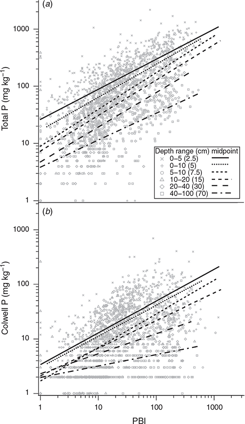
Using the samples collected in 2006 taken to 100 cm from across the catchment, a strong relationship was found between the TP stored in the 0–10 cm and the 0–100 cm depth of the soil profile (Fig. 3a, b). The relationship in Fig. 3b was then used to estimate P storage to 100 cm from the larger 0–10 cm dataset.

|
A strong relationship between PBI in the 0–10 cm and P stored to 100 cm was also identified in the spatial data (Fig. 3c).
P accumulation and P buffering
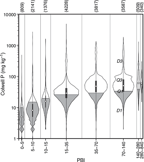
Colwell P accumulates in the topsoil more in high PBI soils than low PBI soils. The proportion of low PBI soils with sufficient Colwell P for 95% of RY (P95) was much lower than for high PBI soils (Fig. 4).
|
There was systematic variation in the positive depth-wise relationships between log TP or log Colwell P and log PBI (Fig. 5a, b). The slope of the relationship decreased systematically with depth for Colwell P, but less so for TP.
|
There was generally a reduced P retention capacity of the topsoil relative to subsoil layers (Fig. 6a, b) with the reverse of a generally higher saturation of P in the topsoil relative to the subsoil (Fig. 6c, d).

|
Phosphorus retained in the topsoil increased with increasing PBI and more marked stratification shown as accumulation of P in the topsoil was found for higher PBI soils. A larger proportion of high PBI soils had more than enough P to meet the requirement for 95% RY (P95) (Gourley et al. 2019) than lower PBI soils, which had proportionally less sites with sufficient P to reach the same critical value (Fig. 7).

|
Temporal variation in P fertility index
The median P90 fertility index was 1.13 in 1983. That is, Colwell P values were typically 13% higher than required to achieve 90% RY in 1983 (Fig. 8). The median P90 fertility index increased to 1.69 by 2018. The relationship between P90 fertility index and time between 1983 and 2018 had a significant positive slope of 0.016 (Fig. 8). This period included soil testing programs from 1983–1991 and from 2009–2018, with a gap of 15 years (1991–2006) without a soil testing program.

|
Spatial distribution of P and P sorption
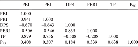
The spatial distribution of P sorption metrics, PBI (Fig. 1c) and PRI (Fig. 1d), were similar and were also strongly associated with each other (r = 0.941; Table 4), where P retention of the topsoil is low (PRI < 5) in the west of the catchment closest to the Peel–Harvey estuarine system.
|
DPS and PERI are strongly correlated (r = 0.835; Table 4). DPS values were mainly in the range of 10–20 while much of the catchment had PERI values greater than 1 (Fig. 1e, f).
The distribution of TP in the top 10 cm (Fig. 1g) in the catchment was correlated with PRI and PBI (Table 4). The P95 fertility index (Fig. 1h) shows a similar but more complex pattern than TP (r = 0.638; Table 4). The P95 fertility index was correlated with PBI and PRI (PBI: r = 0.408, PRI: r = 0.307; Table 4).
Other limiting factors
Sixty nine percent of samples had more P than required for 90% of RY, 67% of samples were K deficient, 26% were S deficient, and 92% required lime (pH < 5.5) for optimum pasture production (Fig. 9).
Discussion
The control of soluble P presents a major global challenge to sustainable agricultural management because high levels of P saturation of soil contribute to the release of P into watercourses (Kleinman 2017). The accumulation of P, measured as soil test P and often termed legacy P, is a well-documented threat to water quality and requires effort to draw down soil P reserves to manage the threat (Rowe et al. 2016; Withers et al. 2019). This challenge posed by legacy P stores and soluble P (Summers et al. 2014; Weaver and Summers 2014) also exists in the Peel–Harvey coastal catchment and is a problem that is increasing with time (Figs 1g, h, 8). When coupled with other soil constraints (Fig. 9) that are likely to limit P uptake by plants (van der Ploeg et al. 1999), P loss in a soluble form from legacy sources represents a significant challenge in the Peel–Harvey coastal catchment.
Sandy soils with limited P retention capacity located near the Peel–Harvey estuarine system have little capacity to build up P or to stop P from entering into nearby waterbodies and are a high priority for management. In this environment, the traditional practice of riparian revegetation is ineffective at retaining P, which is transported in a soluble form (McKergow et al. 2003; 2006a; 2006b; Summers et al. 2014; Weaver and Summers 2014); therefore, minimising P application or increasing soil P retention are important strategies. Although voluntary soil testing has been used to encourage landholders to apply only the nutrients required, this appears to have had limited, if any, effect on reducing legacy P stores to date, as evidenced by gradual increases in the P90 fertility index (Fig. 8). Despite this, there is some evidence emerging that soil testing programs may lead to reductions in fertiliser application (Summers et al. 2020).
One of the few effective and long-lasting treatments to reduce P movement from sands is soil amendment. Sandy soils can be modified to substantially reduce P losses by applying high P-sorbing materials such as bauxite residue (Alkaloam), which is produced in alumina refineries in the Peel–Harvey catchment (Vlahos et al. 1989; Summers et al. 1993; Ward and Summers 1993), or the use of clay from mineral sands mining (Summers et al. 2020). Soil amended with bauxite residue in 1991 reduced the P concentration from a 4300 ha catchment of the Peel–Harvey by ~70% and this has continued for more than 25 years (Summers et al. 2020).
The Peel–Harvey coastal catchment comprises a distinct range of soil types, which influence how P accumulates in the soil. The soils to the west have a lower P buffering capacity, and thus little capacity to retain P, resulting in soil P levels falling more quickly below target levels (Gourley et al. 2019) and requiring annual P applications to meet agricultural production requirements. In the east, soils have a higher P retention capacity; the erosion of high iron and aluminium soils from laterite and granitic soil origins along the Darling Scarp has contributed to their capacity for P retention. These eastern soils can support surface irrigation and the higher productivity has favoured dairy farming. This results in a greater capacity to fund application of P and stockfeed containing P, resulting in P accumulation that exceeds the requirements for agricultural production targets.
The soils of the Peel–Harvey coastal catchment have become greatly enriched from P application since clearing and superphosphate application. Storage of 1221 kg ha–1 m–1 of P is equivalent to more than 10 tonnes of superphosphate retained by the top 100 cm of soil, or ~70 years of 140 kg of superphosphate ha–1 year–1, excluding the P removed in product (mainly beef) and lost in run-off.
Stratification of P in soils has previously been reported at two sites in the Peel–Harvey coastal catchment (Ryan et al. 2017) where P distribution in the top 10 cm was examined. In the current study, sampling of soil profiles at a wider scale, to greater depth, and at finer depth increments shows a similar distinct stratification of P accumulated in the topsoil, with much less P found in the subsoil (Fig. 7a, b). The median Colwell P of the assembled data in the 0–10 cm layer was 31 mg kg–1 while typical Colwell P values for virgin soils (0–10 cm) in SWWA are <2 mg kg–1; however, soils farmed for more than 30 years had a median Colwell P of 29 mg kg–1 (Weaver and Reed 1998). Soils with a lower PBI were unable to retain much P, except in the top few centimetres of soil. This suggests limited P leaching to depth for soils with high PBI, but also limited capacity of soils with low PBI at any depth to increase Colwell P (Figs 2, 7). These low PBI soils accumulated a high proportion of P in the topsoils, most likely associated with organic matter in the topsoil (Tables 2, 3) rather than sorption on soil surfaces. In contrast, there was very low retention of P in the 10–100 cm subsoil of low PBI soils, which contained much less organic matter. This is of significance because organic matter breakdown over summer has the potential to release P during autumn rain and contribute to run-off into watercourses (Weaver et al. 1988).
The limited P enrichment of high PBI soils to depth indicates only a small degree of mixing, preferred pathways, and leaching. This has implications for the risk of P loss via different transport pathways for soils with varying texture and PBI. Coarse textured soils with low PBI will leach P. Conversely, high PBI soils accumulate P in near-surface layers, risking the desorption of soluble P and loss via surface run-off rather than from leaching. High levels of P in topsoil also increases the risk of P loss via erosion of soil particles that carry P into waterways, with potential accumulation in streambed sediment and later release to the water column (McDowell 2015; Clarendon et al. 2019).
Limitations of other nutrients in the presence of excess P may contribute to reduced P uptake, reduced removal and export in agricultural product, increasing the potential for loss. While we found P stratification and accumulation beyond agronomic requirements to be widespread, other constraints (K, S, pH) were common (Fig. 9). Stratification of K is also evident but generally not sufficient to overcome deficiency. In the Peel–Harvey on the west coast of WA, we found the median Colwell K in the 0–10 cm layer was 70 mg kg–1, whereas the median Colwell K for the 0–10 cm layer on soils farmed for more than 30 years on the south coast of WA was 106 mg kg–1 (Weaver and Reed 1998). Colwell K values to achieve 95% RY range from 126 to 161 mg kg–1 (Gourley et al. 2019), suggesting that despite accumulation of K in the topsoil there remains K deficiency in both topsoils and subsoils. A median KCl-40 S value of 9.5 in the 0–10 cm layer slightly exceeds the critical S value of 8 to achieve 95% RY (Gourley et al. 2019). Soil pH(CaCl2) median values of 4.4 in the topsoil and 4.5 in the subsoil indicates acidic conditions that are likely to adversely affect plant growth and nutrient uptake (Truog 1918). These values are similar to those previously reported on the south coast of WA (Weaver and Reed 1998; Weaver et al. 2020). Soil tests for Colwell P, Colwell K and KCl-40 S increased with increasing soil pH, following the general trend of increased nutrient availability as pH increases from acidic values (<4.5) to neutral pH (Truog 1918). Median soil OC values in topsoil were around three times those in subsoils and very similar to those reported by Weaver and Reed (1998); that is, 3.1% for soils farmed for more than 30 years.
Median values of measures of P sorption in both topsoil and subsoil suggests that the soils are weakly to moderately adsorbing (Allen and Jeffery 1990) or classified as moderately low to medium sorbing when using PBI (Gourley et al. 2019). All these measures were skewed with low P sorption values being favoured. Total P values in subsoils were around half that of topsoils and are typical of the limited P sorption capacity of soils in the region.
Researchers have long recognised that the P sorption characteristics of soils influence plant-available P and soil P status (Ozanne and Shaw 1967; Brennan et al. 1994; Weaver and Reed 1998; Burkitt et al. 2002; Moody 2007; Gourley et al. 2019). Soil PBI accounts for the accumulation of P in the soil, and therefore provides an indication of the P sorption potential of the soil before P is added. Soil PRI is a measure of the current soil P sorption potential, which reduces after repeated P application and accumulation in the soil. Like PBI, Ammox Fe is an indirect measure of P sorption potential of the soil and is not expected to be impacted by soil P content. As such, PBI and Ammox Fe are measures of P sorption that would be expected to remain constant with repeated P applications. Soil PRI shows a steeper trend by depth than PBI in most Ammox Fe groups (Fig. 6a, b) demonstrating the cumulative effect of P applications on reducing soil P sorption potential. This accumulation of P and subsequent reduction in P sorption has been explored by Barrow et al. (2018) and the continued application of P causes accumulation to very high levels in high PBI soils where the P sorption capacity can be overwhelmed and P may begin to desorb as soluble P into run-off (Rivers 2012). Poor P retention capacity of low PBI soils, along with propensity to lose P by leaching or run-off, is likely to have contributed to low Colwell P and TP.
The greatest P enrichment of the soil has occurred in the top 5 cm as would be expected for surface-applied fertiliser on permanent pasture, but enrichment continues deeper into the soil profile indicating leaching, occasional incorporation, or P movement via preferred pathways in all soil types.
Phosphorus saturation of the topsoil is widespread, as shown by the spatial distribution of DPS and PERI (Fig. 1e, f). Most of the catchment has a PERI of >0.4, which is considered to maintain soil solution P concentrations of 0.2 mg P L–1, consistent with optimum soil solution P concentrations for plant growth of 0.15–0.3 mg L–1 (Asher and Loneragan 1967; Russell and Russell 1973). Threshold values of DPS above which P loss increases significantly for a range of soils have been reported previously as being within the range of 10–20 (Nair 2014). Much of the catchment is within this range (Fig. 1d). The good correlation between DPS and PERI (Tables 3, 4) suggests that PERI may be a useful analogue for DPS and draws on more contemporary and direct P sorption measures such as PBI (Burkitt et al. 2002).
The heavier, highly P retentive soils that have built up P in the topsoil (Fig. 7a, b) have been shown to be losing P by desorption, especially in intensively grazed irrigation areas in the south-east of the Peel–Harvey coastal catchment (Rivers 2012), similar to observations elsewhere in Australia (Nash and Murdoch 1997; Dougherty et al. 2006; Nash et al. 2007; Kleinman 2017). In inundated areas or where there is strong stratification of P in the soil, PERI or DPS from a 0–10 cm soil sample may not provide an appropriate indication of P loss risk. Soils that are highly P stratified with P saturation in the top few centimetres may desorb P into run-off water, resulting in soluble P concentrations of 4 to 6 mg P L–1 (Dougherty et al. 2006; Rivers 2012). Laboratory assessment of PERI or DPS from a 0–10 cm soil sample saturated with P at the surface would be diluted with higher PBI soil less saturated with P from deeper parts of the sample when collected for analysis for agronomic purposes. The homogenisation of the stratified sample would mask the highly P saturated surface and give the appearance of a soil that could retain more P rather than desorb P. This highlights the importance of collecting soil samples that are fit for purpose for the question being asked, whether that is agronomic or environmental.
Clay soils saturated with P have been managed elsewhere by laser grading irrigation paddocks to disturb and bury the P saturated surface soil and expose P-sorbing subsoil material (Nash et al. 2007). Similarly, increasing the P sorption of stream sediment by using highly P retentive materials to control soluble P has been identified as an option in the Peel–Harvey coastal catchment and south-eastern Australia (Barlow et al. 2003; 2004; Summers et al. 2014).
Combining soil P fertility mapping (Fig. 1h) with hydrological data to identify critical source areas will help target management interventions, minimising its cost and maximising its effectiveness (Cassidy et al. 2019). This is important in catchments of the south-west of WA such as the Peel–Harvey coastal catchment, where run-off has reduced by more than 50% over the study period; this reduction has been attributed to climate change (Kauhanen et al. 2011). Reduction in run-off greatly focuses the efforts to reduce P losses in the critical source areas near drains and watercourses. The westernmost areas have the lowest P retention capacity, they are also saturated with P and are closest to the Peel–Harvey estuarine system, where there is little opportunity to attenuate P loss by overland flow or retention in the drainage system before run-off reaches the estuary.
Although typical P application rates in the Peel–Harvey coastal catchment decreased from 8.1 to 7.7 kg P ha–1 between 1983 and 1991 (Kinhill Engineers 1988; Arkell 1989; Peek and Arkell 1992), these decreased rates are still likely to be in excess of P requirements to maintain optimum production when soils have a P fertility index of 1. By comparison, the median removal of P by cattle is ~2 kg P ha–1 (Weaver and Wong 2011). Even if landholders follow the advice to apply less P, P application is still too high and P is building up, albeit at a slower rate (Fig. 8).
The apparent accumulation of P over the 35-year study period may appear to be a threat to water quality; however, the sampling methodology may have masked some underlying changes in how representative the samples were. The earlier sampling period (1983–1991) aimed to soil test all properties in the catchment, was resourced accordingly, and was widely adopted with 15 309 samples taken from most of the farmed catchment area. Between 2006 and 2018, sampling occurred for only 10 years, with only 3232 samples taken. In this later sampling period, advertising that offered free soil testing to landholders meant that farmers self-selected for inclusion in the program. Crawford et al. (2020) identify some potential issues of bias associated with the use of legacy data rather than from randomly selected sites. In addition, over the period of the study, two distinct farmer groups can be identified, commencing with all farmers in the period 1983–1991, followed by self-selected farmers from 2006 to 2018. Some of these issues along with changes in land ownership, urbanisation and a reduction in the actively farmed area and thus the P applied may contribute to bias. Preliminary assessment of the 2005–2017 fertiliser sales in the Peel–Harvey coastal catchment (Summers et al. 2020) showed reduced fertiliser use in the south of the catchment area, with the lowest fertiliser sales in the northern peri-urban area. This land use change may mean these peri-urban property owners in the north would have little interest in soil testing and would be unlikely to be in the self-selected group who are soil testing. Therefore, there may be a growing area of the catchment that potentially could be reducing the soil P store but the landholders did not come forward for testing. The results may also mean that those landholders who are still farming and fertilising have had their soils tested over the entire sampling period and represent a part of the catchment that is slowly accumulating P in their soil. A different methodology that incorporates a more representative sample to include those farms that were no longer fertilising would be required to investigate this aspect.
Management of all soil types is essential to minimise the build-up of P where undesirable levels of P already occur (Fig. 1h), or where the agronomic optimum for Colwell P at 95% RY is exceeded (Fig. 7a). The continued increase and widespread nature of high P status soils in the study area (Figs 1f, 7) suggests that the long-term subsidised and voluntary approach to soil testing and fertility management has not achieved sufficient behavioural change. This is a concern because soil testing can identify financial savings by reducing P application, which can be diverted to addressing other limiting factors for pasture production, such as K, S, and pH (Fig. 9). Increased productivity, greater water use, greater removal of P in agricultural products, and improved water quality are likely to result from adopting evidence-based fertiliser decisions that are based on soil testing.
In conclusion, this meta-analysis of spatially explicit soil test data from the Peel–Harvey catchment allowed improved understanding of changes in soil P stocks, and the rate and magnitude of the temporal change of metrics such as P fertility index. In addition, the stratification of soil P and depthwise changes in P sorption and saturation have been identified, reinforcing and expanding on the conventional wisdom around the loss of P via different transport pathways. The spatial representation of soil P parameters via pedotransfer functions and regression models has assisted to confirm areas of increased water quality risk, much of which is consistent with existing understanding of P loss risk.
Conflicts of interest
The authors declare no conflicts of interest
Declaration of funding
Sampling and analysis was funded through several programs: 1983–1991 sampling was funded by the WA Department of Primary Industries and Regional Development (as it is now known), with analysis by the ChemCentre (as it is now known); 2006 sampling was funded by the Australian Government Natural Heritage Trust through the South West Catchments Council, with analysis by CSBP Limited; 2009–2011 sampling was funded through the Better Rural Fertiliser Management project as part of the WA Government’s Fertiliser Action Plan, with analysis by CSBP Limited; 2011–2012 sampling was funded by the South West Catchments Council, with analysis by CSBP Limited; 2012–2013 sampling was funded by the WA Department of Primary Industries and Regional Development with analysis by CSBP Limited; 2013–2015 sampling was funded by the WA Government through its Natural Resource Management program, with analysis by CSBP Limited; 2016–2019 sampling was funded by the WA Government’s of Royalties for Regions program (Regional Estuaries Initiative), with analysis by CSBP Limited.
Acknowledgements
Numerous current and past staff of the WA Department of Primary Industries and Regional Development are acknowledged for their contribution to collecting and collating the dataset reported here. They include, but are not limited to: Tony Allen, Tegan Archibald, Heidi Blackburn, Martin Clarke, Eric Dobbe, John Grant, Gina Fiorenza, Kus Kuswardiyanto, Paul Matson, Rebecca Ovens, Caroline Peek, Carol Rivers, Peta Richards, Fred Robinson, David Rogers, Deborah Tyler, Bill Russell, Simon Vivian and Brett Vukelic.
References
Allen DG, Jeffery RC (1990) ‘Methods for analysis of phosphorus in Western Australian soils. Report of investigation No: 37 March 1990. Agricultural Chemistry Laboratory, Chemistry Centre of Western Australia.’Arkell PT (1989) Improved fertilizing practices on the Peel-Harvey catchment. Journal of the Department of Agriculture, Western Australia, Series 4 30, 5 https://researchlibrary.agric.wa.gov.au/journal_agriculture4/vol30/iss3/5
Asher C, Loneragan J (1967) Response of plants to phosphate concentration in solution culture I. Growth and phosphorus content. Soil Science 103, 225–233.
| Response of plants to phosphate concentration in solution culture I. Growth and phosphorus content.Crossref | GoogleScholarGoogle Scholar |
Barlow K, Nash D, Turral H, Grayson R (2003) Phosphorus uptake and release in surface drains. Agricultural Water Management 63, 109–123.
| Phosphorus uptake and release in surface drains.Crossref | GoogleScholarGoogle Scholar |
Barlow K, Nash D, Grayson R, Fenton J (2004) Factors affecting the role of irrigation drains as sources or sinks of phosphorus. Irrigation in a total catchment context-sharing the river. Proceedings 2nd ICID Asian Regional Conference on Irrigation and Drainage, Australia, Moama NSW, 14–17 March, 23–29. Available at http://citeseerx.ist.psu.edu/viewdoc/download?doi=10.1.1.542.6481&rep=rep1&type=pdf
Barrow N, Barman P, Debnath A (2018) Three residual benefits of applying phosphate fertilizer. Soil Science Society of America Journal 82, 1168–1176.
| Three residual benefits of applying phosphate fertilizer.Crossref | GoogleScholarGoogle Scholar |
Birch P (1982) Phosphorus export from coastal plain drainage into the Peel-Harvey estuarine system of Western Australia. Australian Journal of Marine and Freshwater Research 33, 23–32.
| Phosphorus export from coastal plain drainage into the Peel-Harvey estuarine system of Western Australia.Crossref | GoogleScholarGoogle Scholar |
Blair G, Chinoim N, Lefroy R, Anderson G, Crocker G (1991) A soil sulfur test for pastures and crops. Soil Research 29, 619–626.
| A soil sulfur test for pastures and crops.Crossref | GoogleScholarGoogle Scholar |
Blakemore L, Searle P, Daly B (1977) ‘Methods for chemical analysis of soils.’ (Department of Scientific and Industrial Research: Lower Hutt, New Zealand)
Borggaard OK, Szilas C, Gimsing AL, Rasmussen LH (2004) Estimation of soil phosphate adsorption capacity by means of a pedotransfer function. Geoderma 118, 55–61.
| Estimation of soil phosphate adsorption capacity by means of a pedotransfer function.Crossref | GoogleScholarGoogle Scholar |
Brennan R, Bolland M, Jeffery R, Allen D (1994) Phosphorus adsorption by a range of Western Australian soils related to soil properties. Communications in Soil Science and Plant Analysis 25, 2785–2795.
| Phosphorus adsorption by a range of Western Australian soils related to soil properties.Crossref | GoogleScholarGoogle Scholar |
Burkitt L, Moody P, Gourley C, Hannah M (2002) A simple phosphorus buffering index for Australian soils. Australian Journal of Soil Research 40, 497–513.
| A simple phosphorus buffering index for Australian soils.Crossref | GoogleScholarGoogle Scholar |
Cassidy R, Thomas I, Higgins A, Bailey JS, Jordan P (2019) A carrying capacity framework for soil phosphorus and hydrological sensitivity from farm to catchment scales. The Science of the Total Environment 687, 277–286.
| A carrying capacity framework for soil phosphorus and hydrological sensitivity from farm to catchment scales.Crossref | GoogleScholarGoogle Scholar | 31207517PubMed |
Clarendon SDV, Weaver DM, Davies PM, Coles NA (2019) The influence of particle size and mineralogy on both phosphorus retention and release by streambed sediments. Journal of Soils and Sediments 19, 2624–2633.
| The influence of particle size and mineralogy on both phosphorus retention and release by streambed sediments.Crossref | GoogleScholarGoogle Scholar |
Colwell J (1965) An automatic procedure for the determination of phosphorus in sodium hydrogen carbonate extracts of soils. Chemistry & Industry 22, 893–895.
Cope J, Rouse R (1973) Interpretation of soil test results. In ‘Soil Testing and Plant Analysis.’ (Eds L Walsh and J Beaton) pp. 35–54. (Soil Science Society of America, Inc: Madison, Wisconsin USA)
Crawford D, Mitchard B, Burton W (2020) Recent Trends in Soil Fertility Across the Farms of East Gippsland. Soil Research 58, 561–575.
| Recent Trends in Soil Fertility Across the Farms of East Gippsland.Crossref | GoogleScholarGoogle Scholar |
DA Lord and Associates (1998) ‘Dawesville channel monitoring programme. Waters and Rivers Commission Report WRT 28’. (Water and Rivers Commission of WA: Perth Western Australia)
Dari B, Nair VD, Sharpley AN, Kleinman P, Franklin D, Harris WG (2018) Consistency of the threshold phosphorus saturation ratio across a wide geographic range of acid soils. Agrosystems, Geosciences & Environment 1, 180028
| Consistency of the threshold phosphorus saturation ratio across a wide geographic range of acid soils.Crossref | GoogleScholarGoogle Scholar |
Dougherty W, Nash D, Chittleborough D, Cox J, Fleming N (2006) Stratification, forms, and mobility of phosphorus in the topsoil of a Chromosol used for dairying. Australian Journal of Soil Research 44, 277–284.
| Stratification, forms, and mobility of phosphorus in the topsoil of a Chromosol used for dairying.Crossref | GoogleScholarGoogle Scholar |
Environmental Protection Authority (2008) Water quality improvement plan for the rivers and estuary of the Peel–Harvey system–phosphorus management. Environmental Protection Authority, Perth, Western Australia. Available at https://www.epa.wa.gov.au/policies-guidance/water-quality-improvement-plan-rivers-and-estuary-peel-harvey-system—phosphorus
Gourley C, Weaver D, Simpson R, Aarons S, Hannah M, Peverill K (2019) The development and application of functions describing pasture yield responses to phosphorus, potassium and sulphur in Australia using meta-data analysis and derived soil-test calibration relationships. Crop and Pasture Science 70, 1065–1079.
| The development and application of functions describing pasture yield responses to phosphorus, potassium and sulphur in Australia using meta-data analysis and derived soil-test calibration relationships.Crossref | GoogleScholarGoogle Scholar |
Helsel D, Hirsch R (1992) ‘Statistical Methods in Water Resources.’ (US Geological Survey: https//pubs.usgs.gov/twri/twri4a3/pdf/twri4a3-new.pdf)
Hintze JL, Nelson RD (1998) Violin Plots: A Box Plot-Density Trace Synergism. The American Statistician 52, 181–184.
Hodgkin E, Hamilton B (1993) Fertilizers and eutrophication in southwestern Australia setting the scene. Fertilizer Research 36, 95–103.
| Fertilizers and eutrophication in southwestern Australia setting the scene.Crossref | GoogleScholarGoogle Scholar |
Jarvie HP, Sharpley AN, Spears B, Buda AR, May L, Kleinman PJA (2013) Water Quality Remediation Faces Unprecedented Challenges from “Legacy Phosphorus”. Environmental Science & Technology 47, 8997–8998.
| Water Quality Remediation Faces Unprecedented Challenges from “Legacy Phosphorus”.Crossref | GoogleScholarGoogle Scholar |
Kauhanen K, Chambers J, D’souza F (2011) Report Card of Climate Change and Western Australian Aquatic Ecosystems. Report to NCCARF Brisbane.
Kinhill Engineers (1988) ‘Peel Inlet and Harvey Estuary Management Strategy: Environmental Review and Management Programme, Stage 2: Technical report.’ (The Depts. Agriculture and Marine and Harbours: Perth, Western Australia)
Kleinman P (2017) The persistent environmental relevance of soil phosphorus sorption saturation. Current Pollution Reports 3, 141–150.
| The persistent environmental relevance of soil phosphorus sorption saturation.Crossref | GoogleScholarGoogle Scholar |
Kleinman P, Bryant R, Reid W (1999) Development of pedotransfer functions to quantify phosphorus saturation of agricultural soils. Journal of Environmental Quality 28, 2026–2030.
| Development of pedotransfer functions to quantify phosphorus saturation of agricultural soils.Crossref | GoogleScholarGoogle Scholar |
McDowell R (2015) Relationship between Sediment Chemistry, Equilibrium Phosphorus Concentrations, and Phosphorus Concentrations at Base Flow in Rivers of the New Zealand National River Water Quality Network. Journal of Environmental Quality 44, 921–929.
| Relationship between Sediment Chemistry, Equilibrium Phosphorus Concentrations, and Phosphorus Concentrations at Base Flow in Rivers of the New Zealand National River Water Quality Network.Crossref | GoogleScholarGoogle Scholar | 26024272PubMed |
McDowell RW, Moss RA, Gray CW, Smith LC, Sneath G (2021) Seventy years of data from the world’s longest grazed and irrigated pasture trials. Scientific Data 8, 53
| Seventy years of data from the world’s longest grazed and irrigated pasture trials.Crossref | GoogleScholarGoogle Scholar | 33568642PubMed |
McGill R, Tukey J, Larsen W (1978) Variations of Box Plots. The American Statistician 32, 12–16.
McKergow L, Weaver D, Prosser I, Grayson R, Reed A (2003) Before and after riparian management sediment and nutrient exports from a small agricultural catchment, Western Australia. Journal of Hydrology 270, 253–272.
| Before and after riparian management sediment and nutrient exports from a small agricultural catchment, Western Australia.Crossref | GoogleScholarGoogle Scholar |
McKergow L, Prosser I, Weaver D, Grayson R, Reed A (2006a) Performance of grass and eucalyptus riparian buffers in a pasture catchment, Western Australia, part 1 riparian hydrology. Hydrological Processes 20, 2309–2326.
| Performance of grass and eucalyptus riparian buffers in a pasture catchment, Western Australia, part 1 riparian hydrology.Crossref | GoogleScholarGoogle Scholar |
McKergow L, Prosser I, Weaver D, Grayson R, Reed A (2006b) Performance of grass and eucalyptus riparian buffers in a pasture catchment, Western Australia, part 2 water quality. Hydrological Processes 20, 2327–2346.
| Performance of grass and eucalyptus riparian buffers in a pasture catchment, Western Australia, part 2 water quality.Crossref | GoogleScholarGoogle Scholar |
Moody P (2007) Interpretation of a single-point P buffering index for adjusting critical levels of the Colwell soil P test. Soil Research 45, 55–62.
| Interpretation of a single-point P buffering index for adjusting critical levels of the Colwell soil P test.Crossref | GoogleScholarGoogle Scholar |
Moody PW (2011) Environmental risk indicators for soil phosphorus status. Soil Research 49, 247–252.
| Environmental risk indicators for soil phosphorus status.Crossref | GoogleScholarGoogle Scholar |
Murphy J, Riley JP (1962) A modified single solution method for the determination of phosphate in natural waters. Analytica Chimica Acta 27, 31–36.
| A modified single solution method for the determination of phosphate in natural waters.Crossref | GoogleScholarGoogle Scholar |
Nair VD (2014) Soil phosphorus saturation ratio for risk assessment in land use systems. Frontiers in Environmental Science 2, 6
| Soil phosphorus saturation ratio for risk assessment in land use systems.Crossref | GoogleScholarGoogle Scholar |
Nair V, Portier K, Graetz D, Walker M (2004) An environmental threshold for degree of phosphorus saturation in sandy soils. Journal of Environmental Quality 33, 107–113.
| An environmental threshold for degree of phosphorus saturation in sandy soils.Crossref | GoogleScholarGoogle Scholar | 14964364PubMed |
Nash D, Murdoch C (1997) Phosphorus in runoff from fertile dairy pastures. Australian Journal of Soil Research 35, 419–429.
| Phosphorus in runoff from fertile dairy pastures.Crossref | GoogleScholarGoogle Scholar |
Nash D, Webb B, Hannah M, Adeloju S, Toifl M, Barlow K, Robertson F, Roddick F, Porter N (2007) Changes in nitrogen and phosphorus concentrations in soil, soil water and surface run‐off following grading of irrigation bays used for intensive grazing. Soil Use and Management 23, 374–383.
| Changes in nitrogen and phosphorus concentrations in soil, soil water and surface run‐off following grading of irrigation bays used for intensive grazing.Crossref | GoogleScholarGoogle Scholar |
Ozanne P, Shaw T (1967) Phosphate sorption by soils as a measure of the phosphate requirement for pasture growth. Australian Journal of Agricultural Research 18, 601–612.
| Phosphate sorption by soils as a measure of the phosphate requirement for pasture growth.Crossref | GoogleScholarGoogle Scholar |
Peek CS, Arkell PT (1992) The Peel Harvey Fertilizer Extension Programme. In ‘Proceedings of the 5th Australian Soil Conservation Conference Perth 1990; Community Action, Landcare in the 1990’s. Ed Hamilton G, Howes KM, Attwater R. ’. (Western Australian Dept of Agriculture: Perth Western Australia)
Rayment G, Lyons D (2011) ‘Soil chemical methods - Australasia.’ (CSIRO Publishing: Collingwood, Victoria)
Rivers MR (2012) Spatial and Temporal Variations and Patterns in Water and Nutrient Dynamics Within Agriculturally-dominated Watersheds in South West Australia. PhD, School of Environmental Systems Engineering and Centre of Excellence in Natural Resource Management, University of Western Australia
Rowe H, Withers P, Baas P, et al (2016) Integrating legacy soil phosphorus into sustainable nutrient management strategies for future food, bioenergy and water security. Nutrient Cycling in Agroecosystems 104, 393–412.
| Integrating legacy soil phosphorus into sustainable nutrient management strategies for future food, bioenergy and water security.Crossref | GoogleScholarGoogle Scholar |
Ruprecht J, Vitale S, Weaver D (2013) Nutrient export (phosphorus). Department of Agriculture and Food, Perth Western Australia. Available at https://researchlibrary.agric.wa.gov.au/books/12/
Russell EJ, Russell EW (1973) ‘Soil conditions and plant growth.’ (Longmans, Green: London)
Ryan MH, Tibbett M, Lambers H, Bicknell D, Brookes P, Barrett-Lennard EG, Ocampo C, Nicol D (2017) Pronounced surface stratification of soil phosphorus, potassium and sulfur under pastures upstream of a eutrophic wetland and estuarine system. Soil Research 55, 657–669.
| Pronounced surface stratification of soil phosphorus, potassium and sulfur under pastures upstream of a eutrophic wetland and estuarine system.Crossref | GoogleScholarGoogle Scholar |
Sharpley AN, Withers PJ (1994) The environmentally-sound management of agricultural phosphorus. Fertilizer Research 39, 133–146.
| The environmentally-sound management of agricultural phosphorus.Crossref | GoogleScholarGoogle Scholar |
Sharpley A, Kleinman P, Heathwaite A, Gburek W, Weld J, Folmar G (2008) Integrating contributing areas and indexing phosphorus loss from agricultural watersheds. Journal of Environmental Quality 37, 1488–1496.
| Integrating contributing areas and indexing phosphorus loss from agricultural watersheds.Crossref | GoogleScholarGoogle Scholar | 18574180PubMed |
Sims JT, Simard RR, Joern BC (1998) Phosphorus loss in agricultural drainage: Historical perspective and current research. Journal of Environmental Quality 27, 277–293.
| Phosphorus loss in agricultural drainage: Historical perspective and current research.Crossref | GoogleScholarGoogle Scholar |
Sims JT, Maguire RO, Leytem AB, Gartley KL, Pautler MC (2002) Evaluation of Mehlich 3 as an Agric.-Environmental Soil Phosphorus Test for the Mid-Atlantic United States of America. Soil Science Society of America Journal 66, 2016–2032.
| Evaluation of Mehlich 3 as an Agric.-Environmental Soil Phosphorus Test for the Mid-Atlantic United States of America.Crossref | GoogleScholarGoogle Scholar | [In English]
Summers R, Guise N, Smirk D (1993) Bauxite residue (Red Mud) increases phosphorus retention in sandy soil catchments in Western Australia. Fertilizer Research 34, 85–94.
| Bauxite residue (Red Mud) increases phosphorus retention in sandy soil catchments in Western Australia.Crossref | GoogleScholarGoogle Scholar |
Summers R, Weaver D, Keipert N, Steele J (2014) Does Riparian Filtration Reduce Nutrient Movement in Sandy Agricultural Catchments? Environment and Natural Resources Research 4, 155–168.
| Does Riparian Filtration Reduce Nutrient Movement in Sandy Agricultural Catchments?Crossref | GoogleScholarGoogle Scholar |
Summers R, Richards P, Weaver D, Rowe D (2020) Soil amendment and soil testing as nutrient reduction strategies for the Peel Integrated Water Initiative. Department of Primary Industries and Regional Development. Perth, Western Australia. Available at https://researchlibrary.agric.wa.gov.au/rmtr/401/
Tamm O (1922) Eine Methode zur Bestimmung de der anorganischen Komponente des Bodens. Meddelanden fran Statens skogsforsoksanstalt Stockholm 19, 387–404.
Tarkalson DD, Mikkelsen RL (2004) Runoff phosphorus losses as related to phosphorus source, application method, and application rate on a Piedmont soil. Journal of Environmental Quality 33, 1424–1430.
| Runoff phosphorus losses as related to phosphorus source, application method, and application rate on a Piedmont soil.Crossref | GoogleScholarGoogle Scholar | 15254125PubMed |
Tian J, Boitt G, Black A, Wakelin S, Chen L, Cai K, Condron L (2019) Mass balance assessment of phosphorus dynamics in a fertilizer trial with 57 years of superphosphate application under irrigated grazed pasture. Nutrient Cycling in Agroecosystems 114, 33–44.
| Mass balance assessment of phosphorus dynamics in a fertilizer trial with 57 years of superphosphate application under irrigated grazed pasture.Crossref | GoogleScholarGoogle Scholar |
Truog E (1918) Soil Acidity I. It’s relation to the growth of plants. Soil Science 5, 169–196.
| Soil Acidity I. It’s relation to the growth of plants.Crossref | GoogleScholarGoogle Scholar |
van der Ploeg RR, Böhm W, Kirkham MB (1999) On the Origin of the Theory of Mineral Nutrition of Plants and the Law of the Minimum. Soil Science Society of America Journal 63, 1055–1062.
| On the Origin of the Theory of Mineral Nutrition of Plants and the Law of the Minimum.Crossref | GoogleScholarGoogle Scholar |
Vlahos S, Summers K, Bell D, Gilkes R (1989) Reducing Phosphorus leaching from sandy soils with red mud bauxite processing residues. Australian Journal of Soil Research 27, 651–662.
| Reducing Phosphorus leaching from sandy soils with red mud bauxite processing residues.Crossref | GoogleScholarGoogle Scholar |
Walkley A, Black IA (1934) An examination of the Degtjareff method for determining soil organic matter, and a proposed modification of the chromic acid titration method. Soil Science 37, 29–38.
| An examination of the Degtjareff method for determining soil organic matter, and a proposed modification of the chromic acid titration method.Crossref | GoogleScholarGoogle Scholar |
Ward S, Summers R (1993) Modifying sandy soils with the fine residue from bauxite refining to retain phosphorus and increase plant yield. Fertilizer Research 36, 151–156.
| Modifying sandy soils with the fine residue from bauxite refining to retain phosphorus and increase plant yield.Crossref | GoogleScholarGoogle Scholar |
Watmuff G, Reuter DJ, Speirs SD (2013) Methodologies for assembling and interrogating N, P, K, and S soil test calibrations for Australian cereal, oilseed and pulse crops. Crop and Pasture Science 64, 424–434.
| Methodologies for assembling and interrogating N, P, K, and S soil test calibrations for Australian cereal, oilseed and pulse crops.Crossref | GoogleScholarGoogle Scholar |
Weaver D, Reed A (1998) Patterns of nutrient status and fertiliser practice on soils of the south coast of Western Australia. Agriculture, Ecosystems & Environment 67, 37–53.
| Patterns of nutrient status and fertiliser practice on soils of the south coast of Western Australia.Crossref | GoogleScholarGoogle Scholar |
Weaver D, Summers R (2014) Fit-for-purpose phosphorus management do riparian buffers qualify in catchments with sandy soils? Environmental Monitoring and Assessment 186, 2867–2884.
| Fit-for-purpose phosphorus management do riparian buffers qualify in catchments with sandy soils?Crossref | GoogleScholarGoogle Scholar | 24395552PubMed |
Weaver DM, Wong MTF (2011) Scope to improve phosphorus (P) management and balance efficiency of crop and pasture soils with contrasting P status and buffering indices. Plant and Soil 349, 37–54.
| Scope to improve phosphorus (P) management and balance efficiency of crop and pasture soils with contrasting P status and buffering indices.Crossref | GoogleScholarGoogle Scholar |
Weaver D, Ritchie G, Anderson G, Deeley D (1988) Phosphorus leaching in sandy soils. I. Short-term effects of fertilizer applications and environmental conditions. Australian Journal of Soil Research 26, 177–190.
| Phosphorus leaching in sandy soils. I. Short-term effects of fertilizer applications and environmental conditions.Crossref | GoogleScholarGoogle Scholar |
Weaver D, Summers R, Rogers D, Richards P (2020) The effect of soil pH on phosphorus content of clover pasture. In ‘Resource management technical report 417.’ (Department of Primary Industries and Regional Development: Perth, Western Australia). Available at https://researchlibrary.agric.wa.gov.au/rmtr/402/
Withers PJ, Hodgkinson RA, Rollett A, Dyer C, Dils R, Collins AL, Bilsborrow PE, Bailey G, Sylvester-Bradley R (2017) Reducing soil phosphorus fertility brings potential long-term environmental gains: a UK analysis. Environmental Research Letters 12, 063001
| Reducing soil phosphorus fertility brings potential long-term environmental gains: a UK analysis.Crossref | GoogleScholarGoogle Scholar |
Withers P, Vadas P, Uusitalo R, et al (2019) A Global Perspective on Integrated Strategies to Manage Soil Phosphorus Status for Eutrophication Control without Limiting Land Productivity. Journal of Environmental Quality 48, 1234–1246.
| A Global Perspective on Integrated Strategies to Manage Soil Phosphorus Status for Eutrophication Control without Limiting Land Productivity.Crossref | GoogleScholarGoogle Scholar | 31589721PubMed |
Yeates J (1993) Soils and fertilizer use in southwestern Australia. Fertilizer Research 36, 123–125.
| Soils and fertilizer use in southwestern Australia.Crossref | GoogleScholarGoogle Scholar |