

Pluto 4D—Australia’s first 4D over a gas field is an outstanding success
Larry Tilbury A B and Andre Gerhardt AA Woodside Energy Ltd, 240 St Georges Tce, Perth WA 6000.
B Corresponding author. Email: larry.tilbury@woodside.com.au
The APPEA Journal 58(1) 395-411 https://doi.org/10.1071/AJ17096
Submitted: 4 December 2017 Accepted: 16 January 2018 Published: 28 May 2018
Abstract
The Pluto 4D seismic survey is Australia’s first 4D survey acquired over a gas field and has been an outstanding success despite the prior high technical risk of not being able to detect 4D differences above the background noise. At the time of the Pluto 4D monitor survey, the Pluto field had been on production for three years and nine months and produced approximately 1 Tcf of gas.
The first monitor survey was acquired by PGS between November 2015 and February 2016 using dual sources and 12 streamers of 7050 m (geostreamer configuration). Also of note was the use of steerable sources to assist with repeatability, and towing the streamers at 20 m to minimise noise. Data was processed by CGG to pre-stack depth migration (PreSDM), took 12 months to deliver and required significant interaction between Woodside geoscientists and CGG to ensure an excellent 4D product.
4D feasibility studies carried out before acquisition showed that saturation changes (related to water ingress) were expected to show strong 4D responses near the gas water contact (GWC) and would be interpretable if the monitor survey was run after approximately three to four years of production. If the monitor survey was delayed, it showed that the pressure response became too large, swamped the 4D differences and made interpretation difficult or impossible.
Strong ‘hardening’ responses on the 4D difference volumes are interpreted as water ingress into the field. Hardening responses are seen in all reservoir sequences in the Triassic from the TR27 to the TR32 units and range from strong (obvious) to weak (possible). Several examples are shown – the strongest response is seen in the large Triassic (TR27.3) valley within an essentially shale prone unit, which shows water ingress into the valley and moving upwards from the GWC towards the producing well.
The results/insights from the 4D data have provided excellent control points for the history matching of the Pluto Field.
Keywords: gas expansion, history matching, Pluto gas field, reservoir monitoring, rock physics, water ingress, 4D feasibility, 4D interpretation.
Introduction
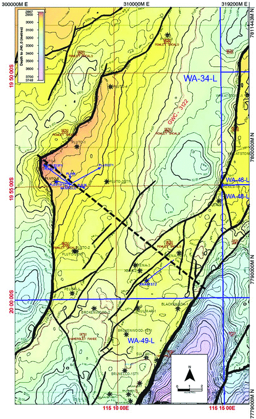
The Pluto and Xena gas fields are located on the North West Shelf of Australia, ~190 km north-west of Karratha and the West Australian coastline, within the WA-34-L production licence (Fig. 1). This region contains several other major gas fields, including Wheatstone (Palmer et al. 2005), Iago, Jansz/Io (Jenkins et al. 2003), Julimar/Brunello, Urania and Dionysus.

|
The Pluto and Xena fields are situated in water depths of 200 to 1000 m beneath the continental slope. The water depth map and associated dip map (Fig. 2) shows the outline of the Pluto field and the complex water bottom topography, comprising large seabed canyons trending north-west and steep scarps running along slope above the field. The presence of this complex topography and steep dips in the overburden have made repeatability of the 4D survey difficult, and we believe has potentially degraded parts of the 4D data (discussed later).

|
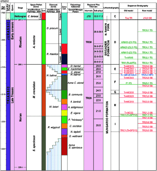
Since the publication of the original Pluto field paper in APPEA 2009 (Tilbury et al. 2009), Woodside has generated a new sequence stratigraphic framework for the North West Shelf of Australia. This new, more regionally consistent nomenclature has been published in various papers, including Adamson et al. (2013), and Marshall and Lang (2013).
The new nomenclature for the Triassic Mungaroo and Brigadier formations is shown in Fig. 3. Note the Pluto and Xena fields extend from the TR26.5 MFS (H.Balmei shale, which forms the base regional seal to the fields) to approximately TR36.1 TS in the Brigadier unit.
|
Overview of the Pluto field
The Pluto field (Fig. 4) is a tilted fault block bounded on the west and north by major bounding faults and sealed by overlying regionally extensive shales. The Triassic reservoir sequence dips gently to the east and subcrops against the regional Jurassic Unconformity (Fig. 5).
|

|
The Pluto field was discovered in 2005 when the Pluto-1 well encountered a gross gas column of around 209 m in Triassic sands of the Mungaroo Formation and Oxfordian sands, sealed by Cretaceous shales of the Forestier and Muderong formations (Tilbury et al. 2009). Petrophysical analyses of the conventional wireline dataset confirmed an average net porosity of 28% and average gas saturation (Sg) of 93% for the Mungaroo Formation (TR28 sands). A production test proved the high deliverability of the Mungaroo (TR28 sands) with the test producing 46.5 MMscf/d.
Since the discovery, the Pluto field has been appraised by a further five wells (Pluto-2 to -6), and the adjacent Xena field, discovered in September, 2006 has also been appraised (Xena-1 to -3). In total, since the Pluto final investment decision, two Woodside exploration wells, Pelion-1 and Eris-1, six development wells on Pluto, and one on Xena have been drilled. Five wells (Brulimar-1, Brunello-1, Brokenwood-1 and -2 and Black Chook-1) drilled in the adjacent acreage by Apache, before it was sold to Woodside, have provided additional information on the Pluto and Xena fields.
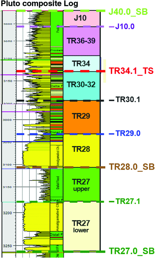
A composite type log of the Pluto field is shown in Fig. 6. This shows the thick amalgamated fluvial multi-valley sands of the Mungaroo (TR27 and TR28 sequences) and the high net-to-gross units of the Brigadier (TR34 sands), which were expected (from prior modelling) to display detectable 4D responses due to the production from the field.
|
Pluto field has been on production since April 2012 (Xena since July 2015) with an annualised loaded liquid natural gas production rate equivalent to 4.7 mtpa (100% project). Currently the Pluto field has six subsea development wells drilled from a single Pluto manifold/drill centre, and Xena has a single subsea well drilled from the Xena manifold.
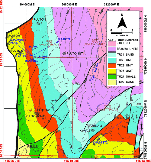
The Pluto wells each target a different reservoir unit from TR27 to TR34 (Fig. 7) to facilitate effective reservoir drainage. The Xena well is completed in the TR28 sands. All wells have targeted seismically defined sands.
|
4D feasibility studies
A 4D feasibility study is typically undertaken well ahead of any planning to determine whether a seismic monitoring program is likely to be successful. It consists of a series of rock physics studies that measure the change in physical (elastic) properties of the reservoir in response to production changes (pressure and saturation). The magnitude of expected changes in these reservoir parameters are compared against an expected level of noise (or normalised root mean square (NRMS)) for the area as a function of acquisition repeatability accuracy and overburden complexity. If this comparison is favourable, the optimal timing and frequency of the monitor surveys can also be estimated.
The first step in building the rock models for a 4D feasibility study consisted of sending several core samples, representative of the range of porosities and net-to-gross observed in all appraisal wells, to the laboratory so elastic properties could be measured using ultrasonic measurements. In this particular case, core samples were kept at confining pressures equivalent to the ones measured at reservoir depth and the pore pressure was gradually reduced to simulate the production method employed in the Pluto field (depletion drive). Then, at regular intervals, compressional and shear velocities were measured, and once all data is collected, a model of the relative change in elastic properties as a function of pressure was built. Additionally, a model can be built using fluid-substitution techniques calibrated to well response to determine the relative change in elastic properties as a result of aquifer drive. The combination of these two models constitutes a petroelastic model, which serves as a basis for a series of simulations.
The first feasibility studies were conducted using log data to which the petroelastic model was applied using saturation and pressure ranges expected from production rates. A large number of realisations were then overlain by the amount of coloured random noise representative of an average NRMS expected for the area as a function of acquisition repeatability, metocean conditions and overburden complexity. This initial study indicated that a decrease of 60% in Sg should be detectable for the high permeability reservoir observed in the area. The pressure signal change (due to modelled production) was expected to be at least 600 psi before a detectable seismic response could be observed above noise levels. As both production effects show the same manifestation on the 4D seismic data (that is seismic response ‘hardening’ with decreasing reservoir pressure and decreasing Sg), it was anticipated that there would be a maximum time for the first monitor survey to be acquired before both signals convolved together, hampering and rendering the interpretation of the 4D changes impossible.
The initial 4D feasibility study was undertaken in 2009 to establish the benefit and optimum timing of 4D seismic for the Pluto field that could be incorporated into the Pluto reservoir management plan. These models were derived from static models with poor reservoir connection into the aquifer. They essentially resulted in depletion drive only, and consequently, pressure changes were the dominant 4D responses expected in the seismic data.
Revised static modelling in 2013 increased the reservoir continuity into the aquifer and triggered a second round of 4D modelling. This second round of modelling used updated reservoir models of a P50 reference model and its P90 equivalent. Using times based on development sequence milestones, time steps selected for the study were 2015 (Xena startup), 2018, 2022 and 2025.
The 2013 reservoir models showed larger changes in Sg compared with the previous models assessed in 2009. The later study concluded that the seismic response associated with such change could be recognised after only a few years of production (for both P90 and P50 cases) and above expected random noise levels for the area.
4D Models—2013 study
The synthetic seismic response differences for the P50 dynamic model are shown in Figs 8 and 9 without any model property background to emphasise the actual response differences. The synthetic seismic difference for 2015–2011 (Fig. 8) shows that the large saturation response at the gas water contact (GWC) level is easily discernible from the lower pressure depletion responses in the overlying reservoirs. Note, however, this is noise-free modelled data, which adds significantly to the interpretability.

|

|
The synthetic seismic difference for 2018–2011 (Fig. 9) shows a large saturation response at the GWC level, but the larger pressure depletion responses in the overlying reservoirs makes the differentiation between saturation and pressure depletion more difficult. Again, however, this is noise-free modelled data, which adds significantly to the interpretability.
In order to gauge our ability to interpret water ingress, the study also investigated whether a saturation response could be seen above expected noise levels for a proposed 4D survey. In general, 20% NRMS is a reasonable noise level to expect for a dedicated monitor survey. As a comparison, Woodside’s Enfield 4D recorded noise levels at around 15% NRMS, although that figure was higher in areas of complex overburden, such as sea floor channels, which are also present in the Pluto field.
A panel of synthetic 4D responses with varying random background noise levels is shown in Fig. 10. At around 20% NRMS, the main saturation responses can still be seen above the background random noise. At 40% NRMS, which is a possibility in areas of complex overburden, the background noise is similar to the expected saturation response and is probably at or above the detection limit for the saturation signal, and hence, interpretation would be extremely difficult or impossible.

|
The 4D feasibility studies over Pluto showed that it was feasible to monitor water encroachment into the thick sand packages of the Mungaroo TR27 and TR28 sands and potentially the high net-to-gross units within the Brigadier (TR34 sands). Noise levels on the 4D survey had to be kept as low as possible to allow confident detection and interpretation of the 4D responses. Further, to be able to confidently interpret the 4D changes, the monitor surveys had to be run before pressure depletion reached ~800 psi, at which time the modelled seismic response differences for pressure depletion and saturation changes become approximately similar and therefore indistinguishable from one another. At expected rates of production, the 4D monitor surveys need to be run after approximately three to four years of production.
4D Models—2015 study
Further modelling was carried out in early 2015 to more accurately model the actual and expected production offtakes, as the field had now been on production for almost three years.
The 4D modelled seismic differences, together with Sg and pressure differences, were generated for time steps 2015 and 2017 (P50 models only). For interpretation purposes, the seismic differences were displayed as relative acoustic impedance (AI) sections rather than reflectivity to constrain the 4D differences to a single loop.
The modelled seismic difference, together with Sg and pressure difference volumes, for the dip line through PLA02, PLA03ST1 and PLA05 is shown in Fig. 11. Strong (hardening) responses, interpreted as water ingress and seen on the saturation property (Fig. 11 top panel), are obvious at the GWC level. Also note there is little or no response in the younger Brigadier units, as PLA05 is now shut-in and very little gas has been produced from these units.

|
The pressure difference property (Fig. 11 bottom panel) predicted strong depletion in the TR28 sands and underlying TR27.3 valley due to the high cumulative production from the associated wells. This strong depletion gives rise to a strong pressure depletion response, which is approaching the same magnitude as the saturation response, and hence, at this level of depletion, interpretation of the actual 4D results may be difficult.
Pluto 4D—Acquisition and processing
The Pluto 4D seismic survey was Australia’s first 4D survey acquired over a gas field and has been an outstanding success, despite the prior high technical risk of not being able to detect 4D differences above the background noise. 4D surveys over gas fields are not common, and only a handful have been published worldwide. The all-pervasive pressure depletion response in gas fields makes depletion drive fields almost impossible to interpret. Only gas fields with measurable saturation responses (i.e. water ingress) have a reasonable chance of success in terms of generating an interpretable 4D signal. The Pluto field falls in this latter category.
The Pluto 3DHD and 4D surveys were acquired by PGS using the PGS Apollo vessel between 18 November 2015 and 5 February 2016 (PGS 2016). The surveys were acquired using dual sources and 12 7050 m streamers (geostreamer configuration), each separated by 100 m. The surveys were processed by CGG to pre-stack depth migration (PreSDM), and data was delivered in August (Pluto 3DHD) and October 2016 (Pluto 4D) and used for reservoir management, infill well planning and reserves estimation.
Acquisition
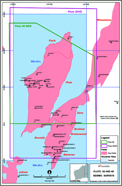
The proposed 4D survey required the close repeatability (with the 2004 Pluto 3D used as a base survey) to achieve the objective of seeing the dynamic changes in the reservoir. The objective of the proposed 3DHD survey was to obtain the best 3D resolution possible to drive improved definition of structural and stratigraphic architecture. These conflicting objectives were solved by acquiring two surveys: the new high-resolution Pluto 3DHD survey (Fig. 12) and the Pluto 4D survey (shot to mirror the Pluto 3D survey also shown in Fig. 12).
|
Of note was the use of steerable sources to assist with repeatability and towing the streamers deep (20 m) to minimise noise. A discussion on the acquisition and the detailed pre-survey planning is given in Fitzpatrick and Pemberton (2017). The acquisition report (PGS 2016) will be available once the seismic data is released by the National Offshore Petroleum Titles Administrator (NOPTA).
Processing
Considerable effort and several iterations of processing were required, especially for the 4D survey, to provide an excellent product for interpretation. For the 4D data, the original 2005 Pluto 3D data was used as the baseline survey and processed concurrently with the new Pluto 4D survey to provide the 4D time-lapse results. The new data had to be ‘dumbed down’ to match the original survey; for example, data from the long cables had to be truncated at 4600 m. The success of the 4D processing can be attributed to the attention to detail and the significant interaction from Woodside geoscientists (both processors and interpreters) and CGG personnel to ensure an excellent 4D product.
Details of the Pluto 4D PreSDM processing sequence are outlined in the final processing reports (CGG 2016) and will be available from NOPTA once the seismic data is released.
Comparison with original seismic data
The new broadband processing significantly improved the seismic data quality with consequent improvement in the resolution of faults and reservoir sequence continuity (Fig. 13).

|
The new PreSDM data has been inverted to AI and ‘fluid’ volumes, which better characterised the internal stratigraphy and delineation of the gas sands over the fields. In particular, apart from the better resolution within the gas leg due to the broadband data, the new inversion is much more definitive, especially within the aquifer.
Pluto 4D results
The Pluto 4D data was acquired between November 2015 and February 2016. For modelling and history matching, the survey was taken on 1 January 2016. At the time of the Pluto 4D, the Pluto field had been on production for three years and nine months and produced approximately 1 Tcf of gas.
Pluto 4D—Water ingress
The most obvious result from the Pluto 4D has been the confirmation of strong (hardening) responses, interpreted as water ingress, in the thick Mungaroo sands at GWC level, similar to those modelled in the 4D feasibility studies.
Hardening responses on the 4D difference volumes are seen in all reservoir sequences in the Triassic from the TR27 to the TR32 units and range from strong (obvious) to weak (possible). The following discussion of 4D results presents a range of examples to show the varying responses across the field and their potential implications.
TR27.3 Valley (Mungaroo)—Water ingress
The TR27.3 valley is a major sand valley extending north-west across the Pluto field in an otherwise shale prone unit. The appraisal well Pluto-6 targeted this valley initially to prove that the seismic inversion fluid volume could be used for development well placement (Tilbury et al. 2009). The well encountered the valley (as predicted) and contained 45 m of gas-filled amalgamated channel sands of the Mungaroo Formation.
A seismic PreSDM fluid line along the TR27.3 valley is shown in Fig. 14. The yellow/red tones are low fluid values (low AI, low Vp/Vs) and are interpreted as gas sands above the GWC. Blue tones are high fluid values interpreted as shales. The valley appears as a zone of strong yellow/red tones reflecting the thick amalgamated channel sands. The PLA01ST1 is completed in the TR27.3 valley and has been on production since 2012.

|
The 4D difference results for the TR27.3 valley are shown in section (Fig. 15) and map opacity slab (Fig. 16). The seismic 4D PreSDM difference line along the TR27.3 valley shows that the thick sands of the TR27.3 valley reservoir unit exhibit an obvious very strong (hardening) response, interpreted as water ingress, extending from the GWC up the valley towards the producing well PLA01ST1 (Fig. 15).

|

|
A 3D opacity view (Fig. 16) shows a striking example of water ingress. Fig. 16 shows the 4D difference (hardening) in blue tones overlain on a fluid volume slice with the TR27.3 valley highlighted in green/red tones. The strong 4D difference anomaly extends up into the valley from the GWC towards the producing well PLA01ST1. Note, in particular the striking correlation with the valley structure and the two small faults that cut the valley.
TR27 Sands (Mungaroo)—Water ingress
The TR27 sands are a major sand package at the base of the Pluto field reservoir sequence. These thick amalgamated channel sands (almost sheet-like) are present in all Pluto and Xena wells. In Pluto, the TR27 gas sands are trapped behind the major western bounding fault and have been appraised by the Pluto-5 and Pluto-6 wells.
A seismic PreSDM fluid line across the TR27 sands at the crest of the field is shown in Fig. 17. Again, the yellow/red tones are interpreted as gas sands above the GWC, and the blue tones are interpreted as shales. In particular, note the strong GWC response on this fluid volume, even though the true sand thickness extends unchanged into the aquifer.

|
The PLA02 development well is completed in the upper TR27 sand and has been on production since 2012. Although it was expected that this well would drain all of the TR27 sand, there was a downside risk that the intervening shale (as seen in the Pluto-5 gamma log shown in Fig. 17) could act as a barrier and only the upper sand would be drained. The Pluto 4D did resolve this downside risk, as it shows that the two sands within the TR27 (lower) unit are both being produced, even though the completion in PLA02 is only in the upper sand (Fig. 17).
The seismic 4D PreSDM difference line across the TR27 sands is shown in Fig. 18 with the TR27 sequence highlighted. The 4D difference (hardening – blue tones) clearly shows water ingress into the TR27 upper and lower sands and confirms that the producing well PLA02 is accessing the full TR27 sand unit.

|
Opacity slabs for both the sands in the TR27 sequence are shown in Fig. 19. These opacity slabs show the water ingress extending up from the GWC (shown in figure as white dashed lines) towards the producing PLA02 well. Note the water ingress is tending to follow the fault traces as the water moves up-dip.

|
The water ingress is reasonably defined in the north (closest to the wells and also outside the main seabed canyon area). Towards the south, the 4D response is nebulous and it is not known if this is due to either the possibility of an unswept area or more likely that the data quality of the baseline survey (from 2004) is poor beneath the strong submarine canyons where we know the seismic data is compromised.
The Pluto 4D data has been used to generate potential water ingress polygons in all the Mungaroo sequences from the TR27 sands to the TR32 sands. The Brigadier units (TR34) and the Xena area (Mungaroo and Brigadier) had insufficient production to show any discernible 4D differences relating to water ingress. The 4D signal varied significantly across the survey (presumably related to the poorer 2004 Baseline survey especially under the main scarp and seabed canyons) so several areas were not as definitive as those shown in the Mungaroo examples above. However, they did show 4D responses in places, and these have been identified for use in the dynamic reservoir modelling.
TR30.1 Sands (Brigadier)—Water ingress
An example of potential water ingress for the TR30.1 sands is shown in Fig. 20. The poorly expressed 4D hardening can be seen in the seismic line just above the interpreted TR30.1 horizon. The corresponding opacity horizon slice/slab shows a moderately defined hardening anomaly (interpreted as water ingress), extending upwards from the GWC. The hardening response is at a similar level to the background noise (as apparent in the seismic difference section of Fig. 20), and it is only its consistency on the opacity slice that indicates that it is most likely a real response. The anomaly is best expressed in the northern part of the field and becomes more nebulous/not present in the south. The anomaly is very consistent with the interpreted GWC in the north, but is poorly consistent in the south (which may indicate potential problems with the depth conversion in this area).

|
Pluto 4D—Gas expansion
One of the most unexpected results from the Pluto 4D has been the strong ‘softening’ responses seen just below the GWC and interpreted to be gas expansion into the aquifer. Gas expansion is not widespread, but where present is shown as a very strong softening response near the contact, which is readily discernible on the 4D difference data.
Seismic 4D difference line 5620 (Fig. 21) shows a strong softening event (yellow/red tones) just beneath the GWC, which is interpreted to be gas expansion into the aquifer.

|
TR27.2 channels/valleys—gas expansion
The gas expansion (strong softening) in the TR27.2 valleys/channels is better expressed in the horizon slices (i.e. parallel to stratigraphy). Three individual expansion ‘bubbles’ are apparent in the left panel of Fig. 22 and appear as small elongate features coincident with channels/valleys interpreted on the Pluto 3DHD inversion volumes. In the right panel of Fig. 22, a second horizon slice, approximately 20 m higher in the section, shows the strong hardening response interpreted as water ingress up the TR27.3 valley discussed previously.

|
The geological features (channels and valleys) can be seen in the horizon opacity slabs from the Pluto 3DHD PreSDM relative AI dataset shown in Fig. 23. The left panel is at the same level as the gas expansion panel above and shows several poorly expressed channels (labelled 2 and 3), which correlate well with the expansion bubbles. As these features are poorly expressed, they are interpreted to be thin (approximately 10 m). Valley 1 is poorly expressed at this level, but at a deeper level Valley 1 is expressed as strong as Valley 2 (shown on the right panel which is 20 m higher). The right panel is at the level of the main TR27.3 valley and shows this major valley extending to the south-east into the aquifer.

|
Combining the gas expansion and water ingress figures into one figure (Fig. 24) it can be seen that the interleaving channels and valleys form a network that is interpreted to be connected in the aquifer. The production from PLA01ST1 has resulted in both the water ingress in the TR27.3 valley, and through the connections in the aquifer, a u-tube effect causing gas expansion in the small channels/valleys, which then provide additional energy to the system.

|
Conclusions
The Pluto 4D Reservoir Monitoring Project, the first in Australia over a gas field, has been an outstanding success amongst a small number of similar projects worldwide.
The following 4D responses are seen in all reservoir sequences in the Triassic from the TR27 to the TR32 units currently being produced in the Pluto field:
-
Hardening responses interpreted as water ingress range from strong (obvious) to weak (possible), but all are consistent with the geology and extend upwards from the GWC.
-
Softening responses interpreted as gas expansion into the aquifer, and although not widespread, occur in several areas and highlight connectivity of gas reservoirs through the aquifer.
The Pluto 4D results/insights have provided an excellent, additional layer of control for the history matching of the field. The water ingress polygons have been used to assist with reservoir connectivity/plumbing and the resultant water movement into the field. They have resulted in a better understanding of the reservoir connection to the aquifer and help define overall aquifer connectivity. In addition, the water ingress polygons improve the history match quality of each dynamic model.
Conflicts of interest
The authors declare no conflicts of interest.
Acknowledgements
The authors would like to thank Woodside Energy Ltd, Tokyo Gas Australia Pty Ltd and Kansai Electric Power Australia Pty Ltd for permission to publish this paper. We also gratefully acknowledge and thank the other members of the Pluto and development teams. The Pluto 4D success has been built on an incredible attention to detail in the acquisition and processing of the new seismic data. We therefore acknowledge the strong contributions made by Jeremy Fitzpatrick for the success of the seismic acquisition and David Dickinson for the 4D seismic processing.
References
Adamson, K. R., Lang, S. C., Marshall, N. G., Seggie, R. J., Adamson, N. J., and Bann, K. L. (2013). Understanding the Late Triassic Mungaroo and Brigadier Deltas of the Northern Carnarvon Basin, North West Shelf, Australia. In Moss, S.J. & Keep, M. (eds) West Australian Basins Symposium 2013 Proceedings, Perth, WA.CGG. (2016) Pluto 4D PreSDM 2015: Final Processing Report. Australian Government.
Fitzpatrick, J., and Pemberton, G. (2017). Planning for Success; Acquiring Australia’s first 4D time lapse survey over a Gas Field, Pluto Reservoir, North West Shelf. In ‘79th EAGE Conference & Exhibition, Paris, France, June 2017’ (extended abstract)
Jenkins, C. C., Maughan, D. M., Acton, J. H., Duckett, A., Korn, B. E., and Teakle, R. P. (2003). The Jansz Gas Field, Carnarvon Basin, Australia. The APPEA Journal 43, 303–324.
| The Jansz Gas Field, Carnarvon Basin, Australia.Crossref | GoogleScholarGoogle Scholar |
Marshall, N. G., and Lang, S. C. (2013). A new Sequence Stratigraphic Framework for the North West Shelf, Australia. In ‘West Australian Basins Symposium 2013 Proceedings, Perth, WA’. (Eds S.J. Moss and M. Keep).
Palmer, N., Theologou, P., Korn, B. E., and Munckton, T. (2005). The Wheatstone gas discovery: A case study of Tithonian and Late Triassic fluvial reservoirs. The APPEA Journal 45, 333–347.
| The Wheatstone gas discovery: A case study of Tithonian and Late Triassic fluvial reservoirs.Crossref | GoogleScholarGoogle Scholar |
PGS (2016). Pluto 4D MSS 2015: Acquisition Operations Report – Final. Australian Government.
Tilbury, L. A., Clayton, C. J., Conroy, T. J., Philip, G., Boyd, G. A., Johnson, G. A., Rayfield, M. A., Hartanto, L., and Lance, D. P. (2009). Pluto – A major gas field hidden beneath the continental slope. The APPEA Journal 49, 243–268.
| Pluto – A major gas field hidden beneath the continental slope.Crossref | GoogleScholarGoogle Scholar |

Larry Tilbury graduated from the University of WA in 1971 with a BSc (Hons) in Physics and Mathematics. His working career spans more than 45 years, including 10 years (1971–81) as a geophysicist in the Marine Group of the BMR where he worked in acquisition, processing and interpretation in most of the offshore basins of Australia, and more than 35 years with Woodside (since 1981) working as an interpreter in exploration and development on the North West Shelf of Australia and the Gulf of Mexico. He is the Principal Geophysicist in the Pluto Development Subsurface Team currently working on the recently acquired Pluto 4D and high-resolution Pluto 3D. His main interests are 3D and 4D interpretation, particularly image processing and seismic inversion studies for reservoir characterisation. He is a member of SEG, ASEG, PESA and EAGE. |

Andre Gerhardt has been involved in a broad spectrum of geophysical technologies ranging from seismic acquisition and processing to quantitative interpretation and reservoir monitoring for almost 30 years. He is currently a Technology Manager with Woodside Energy and previously the Head of Quantitative Interpretation. He is also in charge of Seismic Amplitude Analysis and Risking, with broad experience analysing prospects and opportunities worldwide. Andre has worked on several time-lapse projects in Australia and abroad and is currently working on technologies that enable identification of residual gas, amongst others. Andre has previously worked for Petrobras and holds a BSc in Geosciences and an MSc in Computer Science. |