

Mapping anthropogenic fill with GPR for unmarked grave detection: a case study from a possible location of Mokare’s grave, Albany, Western Australia
Paul Bladon 1 5 Ian Moffat 1 2 David Guilfoyle 3 Alice Beale 4 Jennifer Milani 11 Department of Archaeology, Flinders University, GPO Box 2100, Adelaide, SA 5001, Australia.
2 Research School of Earth Sciences, The Australian National University, Canberra, ACT 0200, Australia.
3 Applied Archaeology, PO Box 4025, Albany, WA 6330, Australia.
4 Anthropology and Archaeology Department, Western Australian Museum, Locked Bag 49, Welshpool DC, WA 6986, Australia.
5 Corresponding author. Email: paul.bladon@gmail.com
Exploration Geophysics 42(4) 249-257 https://doi.org/10.1071/EG11018
Submitted: 8 April 2011 Accepted: 7 October 2011 Published: 23 November 2011
Abstract
Geophysical techniques are a commonly used, non-invasive method for the location of unmarked graves. Contrary to popular perception, most studies rely not on directly imaging skeletal material but instead on locating the subsurface disturbance created by grave digging. This approach is effective only when sufficient contrast exists between detectable properties (such as structure, mineralogy or porosity) of the grave fill and the surrounding sediment. Resolving these features can be particularly problematic in disturbed areas where other anthropogenic fill is in place, as it is often complex in character and lacks a natural stratigraphy.
In many cultural heritage projects, it is often more important to ensure that burials are not disturbed rather than to specifically locate them. Under these circumstances, ground penetrating radar (GPR) can be used to locate modern anthropogenic fill. This may show which areas of the site are younger than the targeted graves and therefore of no archaeological interest. This approach is trialled on a site thought to contain the grave of Mokare, a significant historical figure in the colonial settlement of the Albany area in Western Australia. The delineation of a package of modern fill in the shallow subsurface in the context of the probable history of earthworks on the site demonstrates that Mokare is not buried in the surveyed location. This approach, applied to suitable sites, could contribute to culturally sensitive non-invasive investigation of burial sites in other locations.
Key words: anthropogenic stratigraphy, ground penetrating radar, Mokare, unmarked graves.
Introduction
Geophysics has wide application in archaeological, geotechnical and environmental investigations. Application of geophysical techniques enables exploration of the subsurface in a non-invasive and non-destructive manner and in turn provides a culturally appropriate approach to surveying sensitive locations. Many geophysical techniques are applicable for burial detection; however, ground penetrating radar (GPR) is a particularly effective and widely applied technique. GPR has been used for geological applications since the 1960s, and since the mid-1980s has been increasingly adopted within the engineering and archaeological communities (e.g. Bevan, 1991; Cook, 1960; Imai et al., 1987; Gracia et al., 2000; Reynolds, 1997; Watters and Hunter, 2004).
GPR has been widely applied to the detection of graves, although the direct detection of skeletal material is difficult (Bevan, 1991; Schultz, 2003). Burials are most easily recognised in GPR by grave cuts, particularly where the soil has horizontal stratification (Bevan, 1991; Conyers, 2006). Grave shafts are visible because they cause the truncation of soil horizons and stratigraphic layers, and are then backfilled with mixed soil materials which differ in dielectric properties (Bevan, 1991; Miller, 1996; Vaughan, 1986). This approach is less successful in homogeneous regolith such as some lacustrine and aeolian soil materials (Doolittle and Bellantoni, 2010).
Another potentially fruitful approach is to locate metallic objects associated with the burials, such as metallic coffins or grave goods, which will likely result in high-frequency signatures in GPR data (Bevan, 1991; Novo et al., 2010). Additionally the void inside a coffin can be detectable with GPR (Bevan, 1991; Doolittle and Bellantoni, 2010), however untreated wooden coffins often decompose and collapse within a decade (Doolittle and Bellantoni, 2010). Metallic coffins will be most easily imaged based on their high contrast with soil and resistance to collapse (Doolittle and Bellantoni, 2010; Owsley and Compton, 1997).
To locate burials using GPR there must be minimal post-interment disturbance to the grave fill and surrounding stratigraphy (Conyers, 2006). This disturbance can be caused by animal, plant or human intrusions that alter the contact interface between the vertical shaft backfill and the substrate (Conyers, 2006) or introduce scattering (Bruzewicz et al., 1986; King et al., 1993; Nobes, 2000; Vaughan, 1986). Another impediment to locating graves may occur when a cluster of graves cause overlapping diffractions that are not individually identifiable (Nobes, 1999). This effect may be minimised by the choice of a higher frequency antenna (i.e. Rial et al., 2009) or through appropriate migration during data processing (Barton and Montagu, 2004)
GPR and stratigraphic investigations
GPR has great application to the delineation of geological or anthropogenic features in the subsurface (as summarised by Bristow and Jol (2003a)). GPR can be used for a range of applications including sedimentological investigations, (summarised in edited volumes by Baker and Jol, 2007, Bristow and Jol, 2003b), detection of kimberlite pipes (Power et al., 2004), fault detection (Dentith et al., 2010), landfill studies (Splajt et al., 2003), concrete testing (Grandjean et al., 2000) and a variety of other targets of economic importance (Francke, 2010).
Variations in GPR wave behaviour in sediment are predominately caused by variation in water content (Huggenberger, 1993; McCann et al., 1988). On a small scale, this variation reflects sedimentary structures and hence these may be visible with GPR (Van Dam, 2002). As a result, GPR has been extensively applied to the delineation of stratigraphy including mapping sedimentary facies and stratal geometry (Baker and Jol, 2007; Conyers and Goodman, 1997). For example, the characteristic steeply dipping parallel reflectors in aeolian sediments can be effectively imaged with GPR (Bristow et al., 1996).
GPR data can also be interpreted to calculate energy velocity through the subsurface stratigraphy, which not only establishes true depths, but can also assist in determining lithology (e.g. Pedley et al., 2000; Pringle et al., 2003; Smith and Jol, 1992; Whiting et al., 2001) although this can be compromised by small scale variations in soil moisture (Whiting et al., 2001). Smith and Jol (1992) demonstrate how GPR can be used to determine stratigraphic parameters including bed thickness, dip, and internal structure.
A history of Mokare
Mokare (also known as Mokaré, Mokkare, Mawcurrie, Mokoré and Mǒkarē (Mulvaney and Green, 1992)) is a significant figure in the colonial history of the Albany area in south-western Western Australia. Mokare was a Noongar man who lived in the area immediately surrounding Albany who, following an encounter with Dumont d’Urville in October 1826, became an informant, guide, intermediary and close friend to many members of the European community (Shellam, 2009).
European records of Mokare’s dialogue and actions provide some insights into the functioning of Indigenous society in the area both before the British arrival and during the garrison period (Shellam, 2009). Mokare is also significant to the joint narrative of Indigenous–European relations in his role as liaison and proponent of peace, which, along with other contributing factors, led to a uniquely harmonious co-existence between the Indigenous people and Europeans during this period. Prior to the King George Sound settlement coming under the authority of Captain James Stirling, Mokare had many discussions with Captain Barker, who was Lieutenant Governor of the Swan River Colony at the time, about the changes that might occur when the settlers replaced the garrison troops and convicts (Green, 1984). Mokare also provided Scott Nind with a detailed account of tribal life, which was published in England in 1831 (Nind, 1831).
Mokare died in August 1831 and was buried in an oval shaped grave of four by three by nine feet. The long axis of the grave was orientated east–west, inclining a little to the south-east and north-west. The digging ceased when they reached water at three and a half feet (Shellam, 2009). During the ceremony Mokare’s spear, meara, and kangaroo skin cap were placed on the surface of the burial mound (Goode, 2001).
On the 8th of November 1835 Alexander Collie died in Albany most likely from tuberculosis (Shellam, 2009). Collie’s dying wish was to be ‘laid beside the Native Chief Morkew, whom he himself buried, when Resident of that part of the colony’, a request which was respected with his interment beside Mokare’s grave (Shellam, 2009). However Collie’s dying wish was reneged five years later when Governor Hutt requested his burial be moved from the side of Mokare and re-interred in the new Albany cemetery on Middleton Road. The exact location of Mokare’s grave has been lost, although some evidence for its location is presented in the following section of this paper.
Case study area
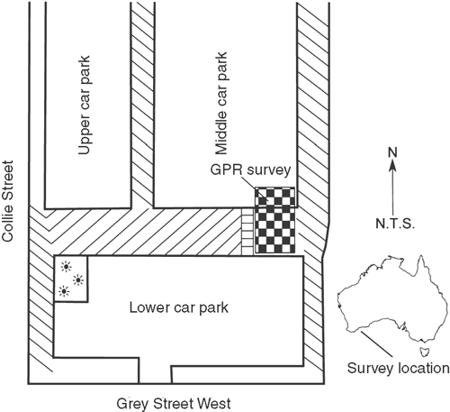
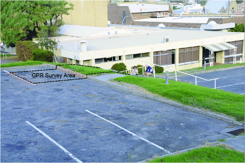
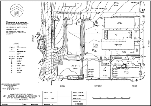
The area for the GPR case study investigation measures ~10 × 6 m and is located in Albany Town Lot S112 on the corner of Collie Street and Grey Street West. This block serves as a car park for the library and town hall located immediately to the east. The study area includes a small section (~6 × 3 m) of bitumen surface located in the south-east corner of the middle level car park and a larger (contiguous) section located on the eastern end of a grassy slope which connects the middle car park with the lower car park (see Figures 1, 2).
|
|
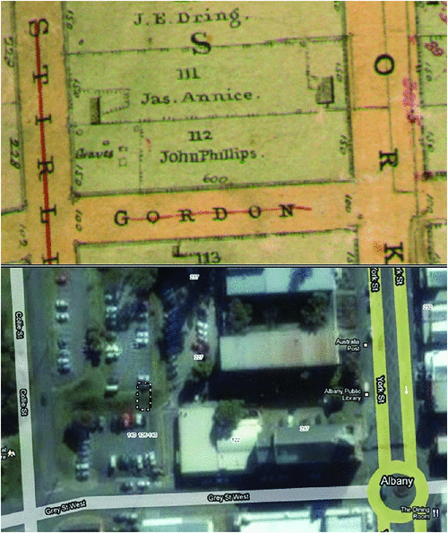
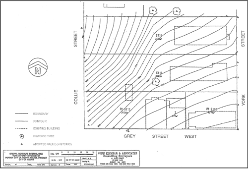
Although Collie (1834) provides a detailed record of Mokare’s burial ceremony, there are no historical records which indicate the exact location of the gravesite. The geophysical survey was undertaken in April 2009 with the study area being chosen based on guidance and advice from the local community. The chosen location conflicts with some oral histories and an early historical map by Chauncy (1851) who was the first town surveyor (an excerpt of this map is provided in Figure 3). An alternative site was suggested in an area of trees in the north-west corner of the lower car park (see Figure 1) where an oval shaped grave can be seen in the map drawn by Chauncy in 1851 (see Figure 3); unfortunately due the dense accumulation of trees GPR was not deemed a suitable method for investigating this location.
|
Historical research had not established definitively that Mokare was buried in Albany Town Lot S112, however anecdotal accounts and town plan maps by Clint (1832), Hillman (1836) and Chauncy (1851) have established that this lot was used informally for the town burial ground sometime from around 1832 (Goode et al., 2005). Chauncy (1851) has five graves drawn on the map (see Figure 3), located upon the north-western end of Lot S112. Four of these graves are drawn as rectangles (suggesting European practices) and one is drawn as an ellipse or an oval (suggesting traditional Indigenous burial practices). From the account by Collie (1834) of Mokare’s funeral it is clear that his grave was dug as an oval to create a burial mound. Collie was also known to be buried with Mokare in 1835 and later exhumed and transferred to Middleton Road in 1840 (Shellam, 2009), before Chauncy’s 1851 map was drawn. It is possible that other burials including that of Mokare’s brother Talwin, as well as numerous traditional Aboriginal people from the Albany area were also located on Lot S112 and the immediate environs of the Albany Town Hall (Goode, 2001).
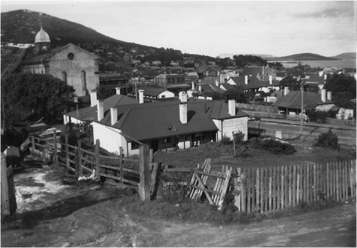
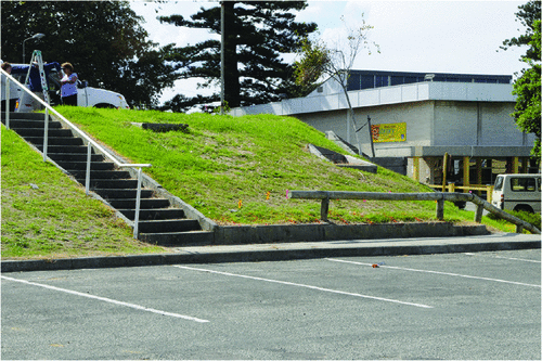
Lot S112 currently slopes to the east from Collie Street to the lawn, and has been subject to a considerable amount of earthmoving since Mokare’s death in 1831 (Goode, 2001). Between 1886 and 1888 a town hall was constructed on or near Mokare’s grave, next to what is now the main street of Albany (Goode, 2001). Two houses were also built to the rear of the Albany Town Hall (see Figure 4) and one of the houses would have stood approximately where currently the lane runs between the senior citizens centre and the car park on the western end of Albany Town Lot S112 (Goode, 2001). The western end of the site was used as a timber stockpile and vegetable garden in the period 1886 to 1954 (see Figure 4), although it is suggested that buildings were not placed over the interpreted location of graves during this period (Goode, 2001). In the 1950s a diesel generator was built on the north-west corner of the site (Goode, 2001). In 1963, during the excavation behind the town hall, two bodies were discovered wrapped in blankets, however there is no evidence that either was Mokare (Goode, 2001; Shellam, 2009). A car park was constructed on the western part of the site in 1970 with significant excavation carried out at this time (Goode, 2001). When the car park was built extensive earthwork was undertaken to make a series of flat ‘benches’ suitable to car park construction. This involved removing approximately 3 m of soil from some areas of the site and the fill shifted to add up to approximately 2 m of soil to other areas of the site (Goode, 2001) (see Figures 5, 6 and 7).
|
|
|
|
Comparison of the pre and post excavation topographies (Figures 5, 6) reveals that the top of the slope in the GPR survey area is at an elevation slightly lower than the original topography and that mid-slope the GPR survey area is slightly more elevated than the original topography.
The study area is underlain by Mesoproterozoic igneous felsic intrusive rock, most likely granite, and has a thin regolith cover (Geoscience Australia, 2010). Soil pH ranges from 4.3 to 4.9 (CSIRO, 2001a) and consists predominately of textured sand (CSIRO, 2001b) and less than 20% silt in the topsoil (CSIRO, 2001c). These geological conditions are excellent for undertaking GPR surveys due to the low clay content, however the high acidity of the soil is not amenable to the preservation of skeletal material.
Lot S112 has had numerous services emplaced in its immediate area including electricity, water, telecommunications, and gas. However no active service lines are shown to exist within the study area on available service plans.
Methods
Survey design
The survey consisted of nine parallel GPR lines trending approximately north–south with a spacing of 0.5 m between lines. The line Mokare1 is the westernmost in the survey and is placed parallel to and ~0.5 m to the east of the easternmost extent of the staircase leading from the middle car park to the lower car park (see Figure 1). All lines begin on the bitumen middle car park ~3 m from its southern boundary. All lines were collected in a southerly direction; initially on the bitumen car park, moving up the gutter on its southern boundary and then continuing south down the steeply inclined grass area between the middle and lower car park before terminating on the southern extent of this feature. Where lines (specifically lines 3, 4 and 5) reach an obstacle (a wooden planter box) they are terminated and a second line started on the southern side of the obstacle.
Instrumentation
The survey was conducted using a RAMAC/MALA X3M GPR with a shielded 250 MHz antenna. Acquisition was undertaken using a survey cart with an odometer that was calibrated against a measuring tape on a flat surface before the survey. Data were acquired using the RAMAC GroundVision program running on a Toshiba notebook computer.
Acquisition parameters
Data were collected using a sample frequency of 5791 MHz, a time window of 65 ns, 378 samples, trace increment of 0.02 m and eight stacks.
Positioning
The location of the GPR lines relative to surface features was measured on site using a survey tape. The start and finish location and line number of each survey line was marked on the site with spray paint.
Data processing
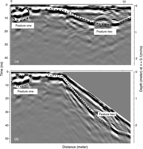
All geophysical data was processed and interpreted using the ReflexW program. Data was processed by correcting the start time based on a picked phase, a bandpass butterworth filter with a lower cutoff of 68 Mhz and an upper cutoff of 715 Mhz, a background remove and average trace filter and an FK migration. Display filters used included ACG and dewow. A processed line before topographic correction is shown in Figure 8a. Lines were topographically corrected using an approximate topography extracted from Figure 7 as shown in Figure 8b.
|
Results
The quality of GPR data acquired during the survey was excellent, with good resolution of features to a maximum of depth of 1 m. An example GPR transect image is shown in Figure 8a, and the same transect with topographic correction in Figure 8b.
Data analysis
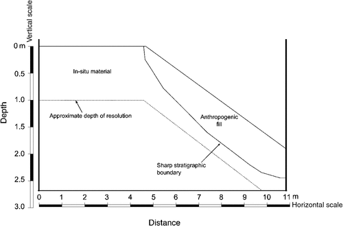
GPR data was consistently similar in all lines and consequently subsurface features could be confidently identified as being continuous between transects. At the beginning of all lines, an area of disturbed soil with numerous discrete hyperbola (removed through migration) was identified (Figure 8a, Feature 1). This feature is interpreted as buried services such as electrical pipes or sewer lines. A lateral discontinuity, as would be expected, is observed where the GPR cart mounts the curb at between 2 m and 3 m on all lines. Some small hyperbola are present in the in situ regolith between 2.5 m to 4.5 m along the lines. A buried surface is observed from 4.80 m to 10.58 m running from the ground level to a maximum depth of 0.82 m (Figure 8a, Feature Two). No interpretable data is present below this surface. A conceptual model of the site stratigraphy is provided in Figure 9.
|
Discussion
This radar survey found no features that could be interpreted as a grave. It did reveal a steeply dipping lens of soil which was ubiquitous to the southern 6 m of all GPR transects. The lower surface of this feature, shown by Feature Two in Figures 8a, 8b, and9, is far too steep to be a natural angle of repose (i.e. Carson and Petley, 1970). This angle suggests that a significant amount of natural regolith has previously been removed and subsequently filled. This indicates that substantial earth works have been undertaken on this site, most likely during the construction of the car park in 1970. Clearly, no burials emplaced before this time can be present in this fill, and no possible burials were revealed below it. Additionally, the ‘bench’ between the middle car park and the lower car park clearly cuts into the estimated original ground level modifying the elevation by ~1.5 m to 5 m along the bench (Figures 5, 6). This precludes the possibility that Mokare’s burial could be preserved intact in this area, due to an insufficient original burial depth.
The source of the anthropogenic fill is unknown, however inspection of early photography and the steep topography of the site (Figures 4, 7) suggests that the excavation was considerably larger than could be filled with the material available on the site. Also, the ethnographic survey conducted by Goode (2001) suggests that when the western end of Lot S112 was excavated in 1970, the resulting fill had been shifted to raise the ground levels adjacent to the lane-way. Modelling of the wave velocity of the fill using hyperbola fitting in the ReflexW program showed that the fill had a slightly faster velocity of 0.15 m/ns compared to 0.13 m/ns for the material interpreted to be in situ. This difference suggests that the fill material has somewhat different material properties than the local sediment. This may suggest either a non local source or that the air filled porosity of this material is higher, probably due to being less compacted.
It is not possible to interpret whether Mokare’s grave existed in the study area before the construction of the car park, nor can its presence in areas adjacent to the study area be excluded. If it is, or was, present in these adjacent areas it is likely that it may not be resolvable with a conventional GPR burial methodology due to the presence of tree roots or metallic interferences (such as Feature 1 in Figure 8a). The most likely source of metallic interferences in the area are obsolete services or buried metal related to activities from when the area was a timber stockpile or diesel generator installation. However, should any burials be located with GPR, the detailed account of Mokare’s distinctive burial including the specific size, shape, orientation, depth and slope provided by Collie (1834) as reported in Goode (2001) would assist in identifying this grave in particular.
Conclusions
A GPR survey of a possible location of Mokare’s grave showed a package of anthropogenic sediment to a maximum interpreted depth of 0.82 m. Given the depth and probable age of this feature, when compared to eye witness descriptions of Mokare’s grave, it is unlikely that this grave is currently located in the study area. This does not preclude that it may have been there before the building of the car park. A conventional view of this survey is that since it did not locate Mokare it is a failure. We argue that a far more important result is the demonstration that the detection of anthropogenic fill with GPR can show that an area is clear of burials. This outcome would have been difficult to achieve convincingly with a conventional GPR survey in which targets are subtle. In contrast, our survey provides a high degree of certainty that no burial is present in this package. This approach has the potential to be applied at many other potentially disturbed sites where non-invasive investigation is desirable.
Acknowledgements
Thank you to ‘The History Collection’ of the Albany Public Library and particularly Naree Ashford for providing historic maps and images. Aunty Vernice Gilles and Rosalie Glynn provided assistance in choosing the location of the GPR survey in Albany Town Lot S112. This survey was funded by the Albany Heritage Reference Group Aboriginal Corporation as part of investigations of Albany Memorial Cemetery. Thank you to staff and students from the ‘Archaeological Field Methods’ field course from the Department of Archaeology, Flinders University, who assisted with the field component of this research. Dr Max Aubert and the Dalmeny Research Station provided ocean front hospitality to Ian Moffat during the initial stages of data processing and analysis. Editorial and reviewer comments have contributed significantly to the brevity and clarity of this manuscript, although naturally the authors remain responsible for any errors.
References
Baker, G., and Jol, H., eds., 2007, Stratigraphic analyses using GPR: Geological Society of America, Colorado, Special Paper 432.Barton, C., and Montagu, K., 2004, Detection of tree roots and determination of root diameters by ground penetrating radar under optimal conditions: Tree Physiology, 24, 1323–1331
Bevan, B., 1991, The search for graves: Geophysics, 56, 1310–1319
| The search for graves:Crossref | GoogleScholarGoogle Scholar |
Bristow, C., and Jol, H., 2003a, An introduction to ground penetrating radar (GPR) in sediments, in C. Bristow, and H. Jol, eds., Ground penetrating radar in sediments: Geological Society, London, Special Publications 211 (1): 1–7.
Bristow, C., and Jol, H., eds., 2003b, Ground penetrating radar in sediments: Geological Society, London, Special Publications 211.
Bristow, C., Pugh, J., and Goodall, T., 1996, Internal structure of aeolian dunes in Abu Dhabi determined using ground penetrating radar: Sedimentology, 43, 995–1003
| Internal structure of aeolian dunes in Abu Dhabi determined using ground penetrating radar:Crossref | GoogleScholarGoogle Scholar |
Bruzewicz, A., Smith, C., Berwick, D., and Underwood, J., 1986, The use of ground penetrating radar in cultural resource management, in Technical Papers 1986: American Congress on Surveying and Mapping/American Society for Photogrammetry and Remote Sensing (ACSM-ASPRS) Annual Convention, Vol. 5, 233–242.
Carson, M., and Petley, D., 1970, The existence of threshold hillslopes in the denudation of the landscape: Transactions of the Institute of British Geographers, 49, 71–95
| The existence of threshold hillslopes in the denudation of the landscape:Crossref | GoogleScholarGoogle Scholar |
Chauncy, P., 1851, Albany, King George’s Sound (Map): Albany History Collection, Albany Public Library.
Clint, R., 1832, Albany Settlement (Map): Albany History Collection, Albany Public Library.
Collie, A., 1834, Anecdotes and Remarks relative to the Aborigines at King George’s Sound, The Perth Gazette and Western Australian Journal, Albany Public Library Local Studies Collection, in N. Green, ed., 1979, Nyungar – The people: Aboriginal customs in the southwest of Australia: Creative Research in association with Mount Lawley College of Advanced Education, North Perth.
Conyers, L., 2006, Ground penetrating radar techniques to discover and map historic graves: Historical Archaeology, 40, 64–73
Conyers, L., and Goodman, D., 1997, Ground-penetrating radar: an introduction for archaeologists: AltaMira Press, Walnut Creek, CA.
Cook, J., 1960, Proposed monocycle-pulse very-high-frequency radar for airborne ice and snow measurement: Journal of the American Institute of Electrical Engineers, Transactions on Communication and Electronics, 79, 588–594
Dentith, M., O’Neill, A., and Clark, D., 2010, Ground penetrating radar as a means of studying palaeofault scarps in a deeply weathered terrain, southwestern Western Australia: Journal of Applied Geophysics, 72, 92–101
| Ground penetrating radar as a means of studying palaeofault scarps in a deeply weathered terrain, southwestern Western Australia:Crossref | GoogleScholarGoogle Scholar |
Doolittle, J., and Bellantoni, N., 2010, The search for graves with ground-penetrating radar in Connecticut: Journal of Archaeological Science, 37, 941–949
| The search for graves with ground-penetrating radar in Connecticut:Crossref | GoogleScholarGoogle Scholar |
Francke, J., 2010, Applications of GPR in mineral resource evaluations, in L. Crocco, R. Persico, L. Orlando, and M. Pieraccini, eds., Proceedings of the 13th International Conference on Ground Penetrating Radar, Lecce, Italy, 21–25 June 2010, 719–723.
Geoscience Australia, 2010, MapConnect Geology Maps. Source Data: Published 1 : 250,000 scale geological maps Geological Survey of WA 1984 and Geoscience Australia, supplemented in parts by more recent stratigraphic classification in GSWA 1 : 500,000 scale Solid Geology dataset 2008, accessed 28 October 2010: http://www.ga.gov.au/mapconnect
Goode, B., 2001, Ethnographic survey of Albany Town Lot S112, Albany, Western Australia. Report prepared for the City of Albany: Albany History Collection, Albany Public Library.
Goode, B., Irvine, C., Harris, J., and Thomas, M., 2005, ’ Kinjarling’, the place of rain: the City of Albany and Department of Indigenous Affairs Aboriginal heritage survey. Report for the City of Albany and the Department of Indigenous Affairs: Albany History Collection, Albany Public Library.
Google Earth, 2010, Map, MapData Services Pty Ltd, DigitalGlobe, accessed 9 November 2010: http://maps.google.com.au
Gracia, V., Canas, J., Pujades, L., Clapes, J., Caselles, O., Garcia, F., and Osorio, R., 2000, GPR survey confirms the location of ancient structures under the Valencian Cathedral (Spain): Journal of Applied Geophysics, 43, 167–174
Grandjean, G., Gourry, J., and Bitri, A., 2000, Evaluation of GPR techniques for civil-engineering applications: study on a test site: Journal of Applied Geophysics, 45, 141–156
| Evaluation of GPR techniques for civil-engineering applications: study on a test site:Crossref | GoogleScholarGoogle Scholar |
Green, N., 1984, Broken spears: Aboriginals and Europeans in the southwest of Australia: Focus Education Services, Perth.
Hillman, A., 1836, Site of Albany 1836 (Map): Albany History Collection, Albany Public Library.
Huggenberger, P., 1993, Radar facies: recognition of facies patterns and heterogeneities within Pleistocene Rhine gravels, NE Switzerland, in J. Best, and C. Bristow, eds., Braided rivers: Geological Society, London, Special Publications 75 (1): 163–176.
Imai, T, Sakayama, T, and Kanemori, T, 1987, Use of ground-probing radar and resistivity surveys for archaeological investigations: Geophysics, 52, 137–150
| Use of ground-probing radar and resistivity surveys for archaeological investigations:Crossref | GoogleScholarGoogle Scholar |
King, J., Bevan, B., and Hurry, R., 1993, The reliability of geophysical surveys at historic-period cemeteries: an example from the Plains Cemetery, Mechanicsville, Maryland: Historical Archaeology, 27, 4–16
McCann, D., Jackson, P., and Fenning, P., 1988, Comparison of the seismic and ground probing radar methods in geological surveying, in Proceedings of the Institute of Electrical Engineering, Part F, 135 (4): 380–391.
Miller, P., 1996, Disturbances in the soil: finding buried bodies and other evidence using ground penetrating radar: Journal of Forensic Sciences, 41, 648–652
| 1:STN:280:DyaK283ovV2guw%3D%3D&md5=6774362db9bf6790f93a7e952400ba19CAS |
Mulvaney, D., and Green, N., eds., 1992, Commandant of solitude: the journals of Captain Collet Barker 1828–1831: Melbourne University Press, Carlton.
Nind, S., 1831, Description of the natives of King George’s Sound (Swan River colony) and adjoining country, The Journal of the Royal Geographical Society of London, in N. Green, ed., 1979, Nyungar – The people; Aboriginal customs in the southwest of Australia: Creative Research in association with Mount Lawley College of Advanced Education, North Perth, 21–51.
Nobes, D., 1999, Geophysical surveys of burial sites: a case study of the Oaro urupa: Geophysics, 64, 357–367
| Geophysical surveys of burial sites: a case study of the Oaro urupa:Crossref | GoogleScholarGoogle Scholar |
Nobes, D., 2000, The search for ‘Yvonne’: a case example of the delineation of a grave using near-surface geophysical methods: Journal of Forensic Sciences, 45, 715–721
| 1:STN:280:DC%2BD3czht1Kqtg%3D%3D&md5=c23fdac6274be34c41a3130439b5d9adCAS |
Novo, A., Lorenzo, H., Rial, F., and Solla, M., 2010, 3D GPR in forensics: finding a clandestine grave in a mountainous environment: Forensic Science International, 204, 134–138
| 3D GPR in forensics: finding a clandestine grave in a mountainous environment:Crossref | GoogleScholarGoogle Scholar |
Owsley, D., and Compton, B., 1997, Preservation in late 19th century iron coffin burials, in W. Haglund, and M. Sorg, eds., Forensic taphonomy: the postmortem fate of human remains: CRC Press, Boca Raton, Florida, 511–526.
Pedley, H., Hill, I., and Denton, P., 2000, Three dimensional modelling of a Holocene tufa system in the Lathkill valley, north Derbyshire, using ground penetrating radar: Sedimentology, 47, 721–737
| Three dimensional modelling of a Holocene tufa system in the Lathkill valley, north Derbyshire, using ground penetrating radar:Crossref | GoogleScholarGoogle Scholar |
Power, M., Belcourt, G., and Rockel, E., 2004, Geophysical methods for kimberlite exploration in northern Canada: The Leading Edge, 23, 1124–1129
| Geophysical methods for kimberlite exploration in northern Canada:Crossref | GoogleScholarGoogle Scholar |
Pringle, J., Westerman, A., Clark, J., Guest, J., Ferguson, R., and Gardiner, A., 2003, The use of vertical radar profiling (VRP) in GPR surveys of ancient sedimentary strata, in C. Bristow, and H. Jol, eds., Ground penetrating radar in sediments: Geological Society, London, Special Publications 211 (1): 225–246.
Reynolds, J., 1997, An introduction to applied and environmental geophysics: John Wiley and Sons, Chichester.
Rial, F., Pereira, M., Lorenzo, H., Arias, P., and Novo, A., 2009, Resolution of GPR bowtie antennas: an experimental approach: Journal of Applied Geophysics, 67, 367–373
| Resolution of GPR bowtie antennas: an experimental approach:Crossref | GoogleScholarGoogle Scholar |
Schultz, J., 2003, Detecting buried remains in Florida using ground-penetrating radar. Unpublished doctoral dissertation, University of Florida, Gainesville, UMI Dissertation Services.
Shellam, T., 2009, Shaking hands on the fringe: negotiating the Aboriginal world at King George’s Sound: University of Western Australia Press, Crawley.
Smith, D., and Jol, H., 1992, Ground penetrating radar investigation of a Lake Bonneville delta, Provo level, Brigham City, Utah: Geology, 20, 1083–1086
| Ground penetrating radar investigation of a Lake Bonneville delta, Provo level, Brigham City, Utah:Crossref | GoogleScholarGoogle Scholar |
Splajt, T., Ferrier, G., and Frostick, L., 2003, Application of ground penetrating radar in mapping and monitoring landfill sites: Environmental Geology, 44, 963–967
| Application of ground penetrating radar in mapping and monitoring landfill sites:Crossref | GoogleScholarGoogle Scholar |
The Commonwealth Scientific and Industrial Research Organisation (CSIRO), 2001a, Topsoil soil texture, Australian Soil Resource Information System, Commonwealth of Australia, accessed 9 November 2010: http://www.asris.csiro.au
The Commonwealth Scientific and Industrial Research Organisation (CSIRO), 2001b, Topsoil pH of areas of intensive landuse in Australia, Australian Soil Resource Information System, Commonwealth of Australia, accessed 9 November 2010: http://www.asris.csiro.au
The Commonwealth Scientific and Industrial Research Organisation (CSIRO), 2001c, Topsoil silt content of areas of extensive landuse in Australia, Australian Soil Resource Information System, Commonwealth of Australia, accessed 9 November 2010: http://www.asris.csiro.au
Van Dam, R., 2002, Internal structure and development of an aeolian river dune in The Netherlands, using 3-D interpretation of ground-penetration radar data: Geologie & Mijnbouw, 81, 27–37
Vaughan, C., 1986, Ground-penetrating radar surveys used in archaeological investigations: Geophysics, 51, 595–604
| Ground-penetrating radar surveys used in archaeological investigations:Crossref | GoogleScholarGoogle Scholar |
Watters, M., and Hunter, J., 2004, Geophysics and burials: field experience and software development, in K. Pye, and D. Croft, eds., Forensic geoscience: principles, techniques, and applications: Geological Society, London, Special Publications Vol. 232, 21–31.
Whiting, B., McFarland, D., and Hackenberger, S., 2001, Three-dimensional GPR study of a prehistoric site in Barbados, West Indies: Journal of Applied Geophysics, 47, 217–226
| Three-dimensional GPR study of a prehistoric site in Barbados, West Indies:Crossref | GoogleScholarGoogle Scholar |