

The predominantly fresh history of Lake Alexandrina, South Australia, and its implications for the Murray–Darling Basin Plan: a comment on Gell (2020)
John Tibby A B E , Deborah Haynes B C and Kerri Muller D
A Geography, Environment and Population, University of Adelaide, Adelaide, SA 5005, Australia.
B Sprigg Geobiology Centre, University of Adelaide, Adelaide, SA 5005, Australia
C Department of Earth Sciences, University of Adelaide, Adelaide, SA 5005, Australia.
D Kerri Muller NRM Pty Ltd, Victor Harbor, SA 5211, Australia.
E Corresponding author. Email: john.tibby@adelaide.edu.au
Pacific Conservation Biology 26(2) 142-149 https://doi.org/10.1071/PC19039
Submitted: 18 October 2019 Accepted: 29 January 2020 Published: 26 May 2020
Journal Compilation © CSIRO 2020 Open Access CC BY-NC-ND
Abstract
The pre-European settlement state of Lake Alexandrina, a lake system at the mouth of the River Murray has been the subject of some debate. Fluin et al. (2007) concluded on the basis of diatom evidence from sediment cores that ‘Marine water indicators were never dominant in Lake Alexandrina’. In a report to the South Australian Government, Fluin et al. (2009) stated, consistent with the earlier research, that ‘There is no evidence in the 7000 year record of substantial marine incursions into Lake Alexandrina’. Gell (2020) has argued both that Fluin et al. (2009) is in error and claims that it, and Sim and Muller’s (2004) book that describes early European settler accounts of the lake being fresh, underpin water provisions for Lake Alexandrina under the Murray–Darling Basin Plan. This response demonstrates that all these claims are untrue. Of the three diatom species suggested by Gell (2020) to be indicators of marine waters, Thalassiosira lacustris grows in the freshwater River Murray today, Cyclotella striata was never more than a minor component of the diatom flora and Paralia sulcata has not been detected in the lake in over 3000 years. Water provisions for Lake Alexandrina under The Basin Plan are founded on contemporary environmental water requirements and achievement of agreed socio-ecological-economic objectives, rather than the history of the lake. Nevertheless, the aim to maintain the lake as a freshwater ecosystem under The Murray–Darling Basin Plan is consistent with its history.
Introduction
Lakes Alexandrina and Albert, known colloquially as the Lower Lakes, are part of the Ramsar-listed Wetland of International Importance at the terminus of the Murray–Darling River system. The 142 500-ha site was listed in 1985 against multiple criteria including cultural significance and the provision of diverse habitats for migratory birds and native fish (Phillips and Muller 2006). The permanent and plentiful freshwater resources of the Lower Lakes have sustained Ngarrindjeri people for many thousands of years (Ngarrindjeri Nation and Hemming 2018) as well as a prime dryland and irrigated agricultural region surrounding the lakes since European settlement in the 1880s, thus making it a Priority Environmental Asset under the Murray–Darling Basin Plan (MDBA 2012), hereafter referred to as The Basin Plan.
Lake Alexandrina has been the subject of palaeolimnological research that has sought to infer the long-term history of the lake itself and as a recorder of past environmental and climate variability. The research has focused on the analysis of a relatively small number of sediment cores in essentially four studies: Barnett (1994), Fluin et al. (2007, 2009) and Herczeg et al. (2001). While Barnett’s Ph.D. thesis (Barnett 1993) analysed a total of 38 cores recovered from Lake Alexandrina, discussion of her work herein is restricted to Core 22, which was the subject of Barnett (1994) and was renamed core LA2 and reanalysed in Fluin et al. (2007). It is this core that is the focus of a recent comment by Gell (2020), to which this reply is directed. Herczeg et al. (2001) also analysed core records from Lake Alexandrina, focussing on much more recent environmental change since ~1865 Common Era.
As a result of the combined effects of unsustainable water resource development (MDBA 2012) and the substantial reductions in effective moisture associated with the Millennium Drought (1996–2010) (BoM 2019), water levels markedly declined in Lakes Alexandrina and Albert, desiccating littoral vegetation and exposing acid sulfate soils around the lakes’ margins. There was a high level of uncertainty as to when the drought would break and how low lake water quality would respond. Modelling by Hipsey et al. (2014) showed that if water levels dropped to trigger levels of −0.5 and −1.5 m Australian Height Datum for Lakes Albert and Alexandrina, respectively, the release of acid from exposed acid sulfate soils would overwhelm the neutralising capacity of the water. The consequent drop in pH levels to 4 or less across ~70% of the lakes would have effectively extirpated a large proportion of the freshwater aquatic biota in the exposed areas (Muller et al. 2018, p. 489).
In this context, a range of management options were considered including opening the barrages that separate Lake Alexandrina from the ocean and The Coorong to allow sufficient seawater ingress into Lake Alexandrina to keep the lakes above their acidification trigger depths (Muller et al. 2018). Given the potential environmental harm associated with the modelled hypersaline conditions (60–100 g L−1) associated with such an action (Muller et al. 2018, p. 489), Fluin et al. (2009) provided a report to the Department of Environment and Heritage (South Australia) that specifically addressed the issue of whether acidification events and marine incursions occurred in the past. Fluin et al. (2009) focused on the last 500 years of the history of Lake Alexandrina, although it drew the conclusion, consistent with previous research, that there was ‘no evidence in the 7000 year record of substantial marine incursions into Lake Alexandrina’ (Fluin et al. 2009, p. 2). The report also considered whether there was any evidence of natural acidification events in the lake and noted that the ‘pH at the sites examined has always remained well above seven’ (Fluin et al. 2009, p. 2).
In this paper we discuss the evidence from previous palaeolimnological studies, provide an explicit definition of ‘substantial marine incursions’, evaluate the merit of the diatom species identified in Gell (2020) as salinity indicators and plot the diatom data against age to demonstrate the evidence in historical context. We also summarise the key early European settlement archives that were used by Sim and Muller (2004) to conclude that Lakes Alexandrina and Albert were ‘predominately fresh’, and the governance pathways used to establish the environmental water provisions for the Lower Lakes in The Basin Plan. The Lower Lakes have also been the subject of significant independent anthropological, historical, ecological, hydrological and geomorphological study by experts from multiple disciplines, as captured recently in the book ‘Natural History of the Coorong, Lower Lakes and Murray Mouth region (Yarluwar-Ruwe)’ (Mosley et al. 2018). We do not provide a summary of this book but simply note that Gell (2020) makes no reference to it and that the multiple lines of evidence presented in it are consistent with the conclusions of Fluin et al. (2007, 2009) and Sim and Muller (2004) outlined below.
Methods
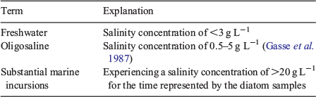
The study site and methods referenced in this paper have been described in Barnett (1994), Fluin et al. (2007) and Sim and Muller (2004). Where reference is made to historical sources their location in Sim and Muller (2004) or the original sources have been provided. The terminology used in this reply is summarised in Table 1.
|
Problems with Gell (2020)
Gell (2020) has erected a ‘straw man’ in three main ways: first, in our opinion, he misinterprets the palaeolimnological evidence by erroneously claiming that conclusions drawn by Fluin et al. (2009) were different from those in Fluin et al. (2007); second, he misrepresents the historical evidence by largely ignoring the conclusions of Sim and Muller’s (2004) comprehensive study; and third, in our opinion, he erroneously suggests that water provisions for Lake Alexandrina under the Murray–Darling Basin Plan are based on Fluin et al. (2009) and Sim and Muller (2004). We discuss these errors of fact and interpretation below in addition to other matters raised in Gell (2020).
Misinterpreting the palaeolimnological and diatom evidence
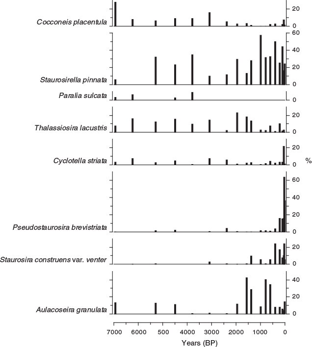
The debate about the history of Lake Alexandrina is essentially one that rests on the location of the boundaries between fresh water, marine water and the mixed zone (i.e. the estuary) between these. The RS1 diatom record from the Goolwa Channel (presented in Fluin et al. 2009; location shown in Fig. 1) has a mix of marine, freshwater and estuarine species. By contrast, it is clear from the diatom evidence that Lake Alexandrina upstream of Point Sturt has been dominated by fresh water, particularly in the last 3000 years. In this context, the conclusions from Fluin et al. (2007, p. 132), which include Gell as an author, are unambiguous: ‘The Holocene diatom assemblages of Lake Alexandrina reflect relatively freshwater conditions’ and ‘Marine water indicators were never dominant in Lake Alexandrina’.

|
Indeed, the very title of Fluin et al. (2007) argues for an ‘independent evolution’ of Lake Alexandrina and The Coorong. This observation arises from the distinct and different histories of Lake Alexandrina and The Coorong as inferred from the estuarine character of The Coorong compared with the freshwater nature of the Lower Lakes. Fluin et al. (2007, p. 132) also note: ‘The Holocene diatom assemblages of Lake Alexandrina reflect relatively freshwater conditions with longstanding and major inputs from the River Murray, particularly after ~2000 years b.p. at site LA2. In the protected site LA1, the freshwater flora is dominated by fresh to oligosaline littoral and facultative planktonic taxa’.
These conclusions are consistent with Barnett (1994), who presented earlier diatom analysis from the same core (named Core 22 in Barnett 1994): ‘It appears that conditions have been mostly oligosaline–freshwater following the formation of Lake Alexandrina, and an overall progressive increase in freshwater conditions could well reflect sea-level stabilisation with a combined influence of river flow variations or marine incursion through the mouth’ (Barnett 1994, p. 266).
The diatom record in Barnett (1994) was produced by Daniel Penny at Monash University, where the term ‘oligosaline’ was used, sensu Gasse et al. (1987), to indicate waters that were between 0.5 and 5 g L−1 salinity and certainly not in the range that indicates substantial marine incursions.
These observations are also consistent with Herczeg et al. (2001, p. 82), who show that the organic matter records indicated a shift in Lake Alexandrina from ‘… a dominantly freshwater system prior to about 1920, to an estuarine system by the late 1930s as a result of upstream diversions of water’, a conclusion made well before Fluin et al. (2007, 2009) or Sim and Muller (2004) were published.
Gell’s (2020) argument focuses on the abundance of three taxa claimed to be marine, namely Thalassiosira lacustris, Paralia sulcata, and Cyclotella striata, along with another taxon, Staurosirella pinnata, described as eurysaline. We discuss the representation and ecology of these taxa in turn, while noting that due to the low abundances of the so-called marine taxa, they should properly be considered in association with the dominant taxa, rather than as stand-alone indicators. Gell (2020) notes in the appendix of his comment that none of these taxa are exclusively restricted to marine waters. Indeed, two of these taxa are noted by Gell (2020) as regularly occurring in freshwater environments. One of these (T. lacustris) is found in the modern-day, permanently fresh, River Murray (Tibby and Reid 2004; Gell 2020). This observation alone calls into question the logic of Gell’s (2020) argument. Gell (2020) also suggests that Paralia sulcata is the best indicator of marine waters. While we concur that, of the three taxa discussed, P. sulcata is the least ambiguous, we note three very important points. First, P. sulcata is never more than 10% of the diatom assemblage in the LA2 record; second, P. sulcata has not been observed in sediments younger than 3000 years old in Lake Alexandrina; and third, as noted by Gell (2020), P. sulcata is found across a wide range of salinities, including oligosaline waters (i.e. waters with a salinity of less than 5 g L−1). In this context, the low representation of P. sulcata in the sediments of core LA2 supports the conclusion of Fluin et al. (2009) that there were never substantial marine incursions into Lake Alexandrina and, with regard to the present management of the lake, not at all in the 3000 years preceding European settlement. To clarify this discussion, we define ‘substantial marine incursions’ as those that would raise the salinity at core site LA2 (Fig. 1) to more than 20 g L−1 for the time represented by one or more sediment samples. A salinity of 20 g L−1 represents the boundary between mesosaline and polysaline salinity in Gasse et al. (1987).
Gell (2020) classifies Staurosirella pinnata as eurysaline and suggests that this species is an indicator of high salinities. While we accept that this taxon has been found in high-salinity waters (including in The Coorong) it is equally, if not more, abundant in fresh waters. Indeed, it has been reported from hundreds, if not thousands, of freshwater lakes and streams around the world (e.g. Bennion et al. 2001; Reid 2005; Morales 2010; Morales et al. 2013). It is also found in modern plankton from the River Murray (Fluin 2002) where it reaches over 10% in samples from Morgan and Swan Reach. S. pinnata was found in 31 of 104 south-east Australian freshwater wetlands in the dataset constructed by Tibby et al. (2003) and had a maximum relative abundance of 67% in that dataset. As such, S. pinnata provides no insight into the salinity of Lake Alexandrina as a stand-alone indicator. Indeed, although Gell (2020) fails to acknowledge this, there was a marked increase in this taxon in the RS1 core following barrage installation (Fluin et al. 2009). This evidence suggests a priori that S. pinnata is advantaged by decreased rather than increased salinity in the Lower Lakes. Consequently, any evaluation of the salinity history of Lake Alexandrina should not solely rely on this taxon but rather consider it as part of the suite of taxa in which unambiguously freshwater diatom species form a substantial part of the flora. The same is true for Cocconeis placentula, which is abundant in the LA2 sediments (maximum relative abundance >25%) (Fig. 2) but occurs in freshwater to hypersaline waters.
|
The LA2 diatom data are plotted by age rather than depth (Fig. 2) since this better represents the historical nature of the evidence. The relative abundance data are scaled as equal values on the x-axis. Gell (2020) has represented the LA2 diatoms by exaggerating the abundance of the so-called marine taxa relative to other taxa. This approach contrasts with numerous studies by Gell and colleagues and the notion of diatom ecology and palaeoecology that underpins the diatom research on which Gell (2020) draws. In quantitative prediction of water quality (e.g. Gell 1997) greatest weight is given to the species with the highest relative abundances.
Misinterpreting the historical evidence
Gell (2020) argues that Sim and Muller (2004) prepared ‘A Fresh History’ with funding from a regional government body and neglected to report the findings of the 1902 Interstate Royal Commission that were ‘contrary to their position’, focussing instead on ‘commentary within South Australia’. In fact, ‘A Fresh History’ was funded by the River Murray Catchment Water Management Board, which, although a statutory body under the South Australian Water Act 1997, was a community board consisting mostly of irrigator and dryland farming representatives.
The interpretations of Sim and Muller (2004) were founded on primary historical sources, in particular articles published in local newspapers. Local commentary from the 1820s to 1935 clearly described how European settlers witnessed the freshwater character of the lakes being altered such that seawater incursions were more common and extensive during the 1895–1902 Federation Drought. This was especially the case during periods of high winds, which is consistent with the 1902 Interstate Royal Commission’s statement about the lakes becoming ‘brackish’ after a ‘strong gale’ (Davis et al. 1902, p. 33) rather than the contrary, as argued by Gell (2020).
Prior to this, Captain Charles Sturt in 1838 described the narrow channels and the islands in the southern parts of Lake Alexandrina holding back the river, thereby creating freshwater lakes at a higher elevation than sea level (an observation consistent with the current geomorphological knowledge described by Bourman et al. 2018), as follows: ‘During my late visit I never observed the sea running in, but a strong current always setting out of the channel. I am led to think, that the level of the lake is above high water mark. The narrowness of the channel preventing the body of water thrown into it, by the Murray from being thrown out in the same proportion. The immense body of back water in the chain of lagoons, would be an argument in favour of this supposition’ Sim and Muller (2004, p. 17).
The ‘Overlanders’ who drove cattle long distances talked of the water of Lake Alexandrina being ‘perfectly fresh’ in 1839, with freshwater reedy flats half a mile wide and of losing control of cattle near Lake Albert when they ‘smelt’ freshwater and rushed towards it, stating that it was ‘fresh, and it was not salt; it had a vapid sweet taste, but it quenched our thirst’ Sim and Muller (2004, p. 17). Given the geomorphology of the lakes, Lake Albert is more likely to be the saltier of the two lakes and thus it is notable that in 1840 Surveyor General Frome recorded the water in Lake Albert to be ‘in some parts very good in others slightly brackish but quite fit for use, and from the permanent nature of the huts of the natives, and absence of native wells, I should imagine they continued so the greater part of the year’ Sim and Muller (2004, p. 19).
Local reports record a change in the salinity of the lake around the turn of the century. For example, a test groundwater well was sunk at Milang in 1903 to assess alternative supplies of fresh water for steamboats that had sourced their water direct from the lakes for 50 years. The local Mount Barker Courier paper reported ‘… where previously there was an unlimited supply of beautifully fresh water, fit for almost any purpose, there is now only salt water, and stock-owners and agriculturists are forced to bore for supplies of freshwater to meet their requirements’ Sim and Muller (2004, p. 2). Settlers around the Lower Lakes, who were reliant on them for fresh water, began to agitate for their ‘Riparian Rights’ in 1902 claiming ‘… land was decreasing in value owing to the growing saltiness of the water. The land had been purchased from the Government at high figures owing to the beautiful fresh water frontage which it then possessed’ Sim and Muller (2004, p. 2). In another account from 1902, the Superintendent of the Point McLeay Mission said ‘(previously) … when the lakes were fresh there was considerable feed actually in the water… that the fish have been driven out of the lakes by the salting of the water … Despite the long drought the waters of the lakes have always been sweet at this time of the year, and more or less through the hot weather so that their present condition is quite phenomenal’ Sim and Muller (2004, p. 2).
Long-time Goolwa resident Edward Leslie Goode told an enquiry in 1933 that he could remember ‘…when it was a remarkable thing when saltwater came up to the Goolwa wharf. Now we see saltwater in the lakes for months. In 1901 Lakes Albert and Alexandrina were fresh. Lucern [sic] at Meningie would grow to the water’s edge, and fresh waterweed grew for a mile out into the lake, and cattle stood in the water eating it. At Narrung reeds eight feet high grew, so that a sailing boat could shelter in them, and in the summer they were good stock feed. These also flourished at Point Sturt and in the Currency Creek. At Port Agnes willows were so thick that in a storm a vessel could lie in perfect calm behind them. On the jetty at Point McLeay Mission Station were wool scourers, and at Poltollock [sic] an engine pumping to the garden. Little by little all this has gone; and in my opinion, if we do not stop the flow of fresh water out and salt water in, we will hereafter have the sea up to Swan Reach’ Sim and Muller (2004, p. 64).
The management of the River Murray became a political issue in the 1860s, as the need to provide secure commercial arrangements and water-sharing contests arose (Sim and Muller 2004, p. 23). Reductions in river flows were raised in the South Australian Parliament from 1878. In 1885, the colonies of New South Wales and Victoria signed an agreement that stated ‘… each of the said colonies shall have the right to take and divert one-half …’ of the waters of the River Murray without provision for the downstream use or needs of South Australia (Sim and Muller 2004, p. 25).
The irrigation industry began with individual farmers along the River Murray, followed by larger irrigation schemes from the 1880s. As summarised by Mallen-Cooper and Zampatti (2018), there was a rapid increase from 1893 due to the construction of significant infrastructure (e.g. the Goulburn Weir). It is estimated that by 1901, when locals from the Lower Lakes area were noticing significant changes, 598 GL were being diverted from the Murray River and its tributaries for irrigation in Victoria and New South Wales (Mallen-Cooper and Zampatti 2018).
The River Murray by international standards had very low discharges in its predevelopment state, being only 16% of the River Nile, 3.5% of the Mississippi River and 0.24% of the Amazon River (Eastburn 1990). The River Murray was therefore highly susceptible to adverse impacts from even modest development of water resources. Rankine’s July 1887 statement that ‘… All the floodwaters were required to drive out the salt water [seawater] so as to keep the Lakes and a portion of the lower river fresh …’ and ‘… increase in saltness in the Murray Lakes [was] by reason of diversion of water from the river channel’ (Davis et al. 1902; cited by Gell 2020), are findings that refute those of the Royal Commission in 1902, regardless of ‘cross-state contests over water’ (cited by Gell 2020).
Gell (2020) also fails to acknowledge that Sim and Muller (2004) cite numerous and substantial cultural and linguistic references to obligate freshwater species in the lakes from the Ngarrindjeri people, who are the Traditional Owners of the Lower Lakes, Coorong and Murray Mouth and have continuously occupied this land and waters since before the creation of the modern lake system ~8000 years ago following the Holocene sea level transgression (see also Mosley et al. 2018, chapter 1.1).
Misinterpretation of the science underpinning The Basin Plan
The Basin Plan action to maintain the ecological character of the Lower Lakes and Coorong is not, as Gell (2020), implies based on the historical and/or palaeolimnological data in Sim and Muller (2004) and Fluin et al. (2009). Rather, the provision of water to the Lower Lakes and Coorong through The Basin Plan is focused on several interconnected objectives developed through extensive community engagement and based on best available science. Primarily, The Basin Plan needs to meet the international obligations to maintain the ‘ecological character’ of the site under the Ramsar Convention and the legislative requirements of the Commonwealth Water Act 2007. It also needs to achieve sustainable diversion limits that ensure sufficient river water is available to mitigate four key risks to the long-term health of the river detailed in The Basin Plan, namely: flush salts mobilised from the whole basin out to sea to meet salinity targets throughout the basin; prevent blackwater (hypoxic) events; prevent cyanobacterial blooms; and prevent acidification of the wetlands below Lock 1 by ensuring water levels remain above their respective acidification trigger levels (see MDBA 2014).
Where The Basin Plan policies have targeted specific ecological objectives, these are related to the environmental water requirements detailed by Lester et al. (2011). The salinity targets for the Lower Lakes, detailed therein, are based on the salinity tolerances of key species such as freshwater macrophytes, macroinvertebrates and small-bodied threatened native fish (e.g. Yarra and southern pygmy perch). The Basin Plan water-sharing policies are consistent with the evidence for a mostly freshwater Lake Alexandrina in the pre-European period but neither the Ramsar listing nor The Basin Plan targets are based on the palaeoenvironmental evidence or the historical evidence collated by Sim and Muller (2004). Indeed, this point is previously made by Gell (2017) in relation to the management of The Coorong, where he notes the absence of reference to palaeolimnological evidence in the formulation of management strategies.
Misinterpretation of the geomorphological and modelling evidence
Gell (2020) argues that Bourman and Barnett (1995) and Bourman et al. (2000) support his arguments about Lake Alexandrina being more saline in the past, but in fact they draw the opposite conclusion. Starkly, Bourman and Barnett (1995, p. 101–103) state ‘Under natural conditions, Lake Alexandrina was probably fresher than at present, except at times of low flows and high tides when elevated salinities resulted from seawater incursions’. Bourman et al. (2000, p. 160) noted that the tidal prism had reduced by 90% following barrage emplacement, which Gell (2020) cites as supporting his arguments. However, ‘According to Johnston (1917) the area of the estuary affected by tides was 97.3 km2 (or 9730 ha)’ (Bourman et al. 2000, p. 160), which largely corresponds to the boundary between predominantly fresh and more saline waters shown in Fig. 1. This area represents less than 15% of the total area of Lake Alexandrina proper, which has an approximate area of 76 000 ha (or 760 km2) (Phillips and Muller 2006). Moreover, the extent of tidal influence in 1917 is likely to have been expanded relative to its pre-European extent due to substantial upstream abstractions that drove increases in the salinity of the lakes by the early part of the 20th Century (Mallen-Cooper and Zampatti 2018).
Gell (2020) argues that a study modelling the hypothetical past salinity of Lake Alexandrina supports his conclusions. However, Helfensdorfer et al. (2019) made questionable assumptions in the model settings, none of which are supported by the available evidence, namely: past sea-level highstands of 2 m above current levels, configuration of the Younghusband Peninsula as a series of islands and inferring a very wide Murray Mouth, which at its most constricted is over 1.5 km wide (compared with ~150 m today). A recent review of Holocene sea levels in South Australia showed that sea-level highstands exceeding 2 m occurred only at locations distant from the continental shelf and that ‘[l]ower highstands (+1 m) were recorded at the more southern locations’ (Lewis et al. 2013, p. 129). Diatom data from Cores C3 and C7 in The Coorong, as presented in Fluin et al. (2007), show that the northern Coorong was predominantly estuarine, meaning that lake water penetrated to a distance of at least 20 km from the Murray mouth, a scenario unlikely to occur if the Younghusband Peninsula was a series of islands and the Murray Mouth was 1.5 km wide. Moreover, Helfensdorfer et al. (2019) claim their assumptions are supported by diatom data from Lake Alexandrina. However, the arguments presented here and, in particular, the total absence of marine diatoms in Core LA1 (Fluin et al. 2007, p. 122) indicate that the conclusions of Helfensdorfer et al. (2019) about the extent of marine incursions during the Holocene are not supported.
Gell (2020) makes two erroneous claims about diatom research in The Coorong. He claims, first, that the results of this work were presented at a meeting held in September 2004 (Gell 2020, p. 3) and, second, that he led the interpretation of the diatom records from The Coorong. This is essentially the only reference to Coorong research but we take the opportunity to correct these statements. The Coorong research was not presented at the September 2004 LIMPACS meeting; rather, there was a workshop on how to approach the (then forthcoming) work. Indeed, the coring for The Coorong research occurred over the period 21–25 March 2005 (Fluin et al. 2007, p. 119) and had patently not been undertaken at the time Gell (2020) claims to have presented the results. Moreover, we specifically contest that Gell ‘led’ the interpretation and note that such a claim undermines Haynes’ ability to submit this work as part of her Ph.D.
Conclusion
There are strong complementary lines of evidence indicating that Lake Alexandrina was fresh at the time of European settlement and that this predominantly fresh status existed for millennia before European occupation. This information has been in the public domain for 25 years and the interpretation proffered by Gell (2020) does nothing to alter this. Furthermore, assertions that the history of the Lower Lakes has been used to support water provisions under The Basin Plan are completely without foundation.
Conflicts of interest
John Tibby is married to Jennie Fluin, lead author of Fluin et al. (2007, 2009). Dr Fluin has chosen not to engage further in this debate. The authors declare no conflicts of interest other than this.
Acknowledgements
We acknowledge Lake Alexandrina and The Coorong as Ngarrindjeri Ruwe/Ruwar (Country) and thank the Ngarrindjeri community for permission to undertake research on country. We thank Bob Bourman, Jason Higham, Theresa Heneker and Luke Mosley for valuable discussions. The interpretations provided herein are our own.
References
Barnett, E. (1993). Recent sedimentary history of Lake Alexandrina and the Murray Estuary. Ph.D. thesis, School of Earth Sciences, Flinders University of South Australia, Adelaide.Barnett, E. (1994). A Holocene paleoenvironmental history of Lake Alexandrina, South Australia. Journal of Paleolimnology 12, 259–268.
| A Holocene paleoenvironmental history of Lake Alexandrina, South Australia.Crossref | GoogleScholarGoogle Scholar |
Bennion, H., Appleby, P. G., and Phillips, G. L. (2001). Reconstructing nutrient histories in the Norfolk Broads, UK: implications for the role of diatom–total phosphorus transfer functions in shallow lake management. Journal of Paleolimnology 26, 181–204.
| Reconstructing nutrient histories in the Norfolk Broads, UK: implications for the role of diatom–total phosphorus transfer functions in shallow lake management.Crossref | GoogleScholarGoogle Scholar |
Bourman, R. P., and Barnett, E. J. (1995). Impacts of River Regulation on the Terminal Lakes and Mouth of the River Murray, South Australia. Australian Geographical Studies 33, 101–115.
Bourman, R. P., Murray-Wallace, C. V., Belperio, A. P., and Harvey, N. (2000). Rapid coastal change in the River Murray estuary of Australia. Marine Geology 170, 141–168.
| Rapid coastal change in the River Murray estuary of Australia.Crossref | GoogleScholarGoogle Scholar |
Bourman, R. P., Murray-Wallace, C. V., Ryan, D. D., Belperio, A. P., and Harvey, N. (2018). Geomorphological evolution of the River Murray Estuary, South Australia. In ‘Natural History of the Coorong, Lower Lakes, and Murray Mouth Region (Yarluwar-Ruwe)’. (Eds L. Mosley, Q. Ye, S. Shepherd, S. Hemming, and R. Fitzpatrick.) pp. 71–102. (Royal Society of South Australia Inc., University of Adelaide Press: Adelaide.)
Bureau of Meteorology (BoM) (2019). Recent rainfall, drought and southern Australia’s long-term rainfall decline. Available at: http://www.bom.gov.au/climate/updates/articles/a010-southern-rainfall-decline.shtml [accessed 17 October 2019].
Davis, J., Murray, S., and Burchell, F. N. (1902). Interstate Royal Commission on the River Murray, representing the states of New South Wales, Victoria, and South Australia: report of the commissioners with minutes of evidence, appendices, and plans. Parliament of Victoria, Melbourne.
Eastburn, D. (1990). The river. In ‘The Murray’. (Eds N. Mackay, and D. Eastburn.) pp. 3–15. (Murray–Darling Basin Commission: Canberra.)
Fluin, J. (2002). A diatom-based palaeolimnological investigation of the lower River Murray, south eastern Australia. Ph.D. thesis, School of Geographical and Environmental Studies, Monash University, Melbourne.
Fluin, J., Gell, P., Haynes, D., Tibby, J., and Hancock, G. (2007). Palaeolimnological evidence for the independent evolution of neighbouring terminal lakes, the Murray Darling Basin, Australia. Hydrobiologia 591, 117–134.
| Palaeolimnological evidence for the independent evolution of neighbouring terminal lakes, the Murray Darling Basin, Australia.Crossref | GoogleScholarGoogle Scholar |
Fluin, J., Haynes, D., and Tibby, J. (2009). An environmental history of the Lower Lakes and The Coorong. A report for the Department of Environment and Heritage (South Australia). University of Adelaide, Adelaide.
Gasse, F., Fontes, J. C., Plaziat, J. C., Carbonel, P., Kaczmarska, I., De Deckker, P., Soulié-Marsche, I., Callot, Y., and Dupeuble, P. A. (1987). Biological remains, geochemistry and stable isotopes for the reconstruction of environmental and hydrological changes in the Holocene lakes from North Sahara. Palaeogeography, Palaeoclimatology, Palaeoecology 60, 1–46.
| Biological remains, geochemistry and stable isotopes for the reconstruction of environmental and hydrological changes in the Holocene lakes from North Sahara.Crossref | GoogleScholarGoogle Scholar |
Gell, P. A. (1997). The development of diatom database for inferring lake salinity, Western Victoria, Australia: towards a quantitative approach for reconstructing past climates. Australian Journal of Botany 45, 389–423.
Gell, P. A. (2017). Paleolimnological history of the Coorong: identifying the natural ecological character of a Ramsar wetland in crisis. In ‘Applications of Paleoenvironmental Techniques in Estuarine Studies’. (Eds K. Weckström, K. Saunders, P. Gell, and G. Skilbeck.) pp. 587–613. (Springer: Dordrecht.)
Gell, P. A. (2020). Watching the tide roll away – contested interpretations of the nature of the Lower Lakes of the Murray Darling Basin. Pacific Conservation Biology 26, 130–141.
| Watching the tide roll away – contested interpretations of the nature of the Lower Lakes of the Murray Darling Basin.Crossref | GoogleScholarGoogle Scholar |
Helfensdorfer, A. M., Power, H. E., and Hubble, T. C. T. (2019). Modelling Holocene analogues of coastal plain estuaries reveals the magnitude of sea-level threat. Scientific Reports 9, 2667.
| Modelling Holocene analogues of coastal plain estuaries reveals the magnitude of sea-level threat.Crossref | GoogleScholarGoogle Scholar | 30804465PubMed |
Herczeg, A. L., Smith, A. K., and Dighton, J. C. (2001). A 120 year record of changes in nitrogen and carbon cycling in Lake Alexandrina, South Australia: C:N, δ15N and δ13C in sediments. Applied Geochemistry 16, 73–84.
| A 120 year record of changes in nitrogen and carbon cycling in Lake Alexandrina, South Australia: C:N, δ15N and δ13C in sediments.Crossref | GoogleScholarGoogle Scholar |
Hipsey, M., Salmon, U., and Mosley, L. M. (2014). A three-dimensional hydro-geochemical model to assess lake acidification risk. Environmental Modelling & Software 61, 433–457.
| A three-dimensional hydro-geochemical model to assess lake acidification risk.Crossref | GoogleScholarGoogle Scholar |
Lester, R. E., Fairweather, P. G., and Higham, J. S. (Eds) (2011). Determining the environmental water requirements for the Coorong, Lower Lakes and Murray Mouth region — methods and findings to date. Department of Environment and Natural Resources, Adelaide.
Lewis, S. E., Sloss, C. R., Murray-Wallace, C. V., Woodroffe, C. D., and Smithers, S. G. (2013). Post-glacial sea-level changes around the Australian margin: a review. Quaternary Science Reviews 74, 115–138.
| Post-glacial sea-level changes around the Australian margin: a review.Crossref | GoogleScholarGoogle Scholar |
Mallen-Cooper, M., and Zampatti, B. P. (2018). History, hydrology and hydraulics: rethinking the ecological management of large rivers. Ecohydrology 11, e1965.
| History, hydrology and hydraulics: rethinking the ecological management of large rivers.Crossref | GoogleScholarGoogle Scholar |
Morales, E. (2010). Staurosirella pinnata. In ‘Diatoms of North America’. Available at: https://diatoms.org/species/staurosirella_pinnata [accessed 18 December 2019].
Morales, E. A., Guerrero, J. M., Wetzel, C. E., Sala, S., and Ector, L. (2013). Unraveling the identity of Fragilaria pinnata Ehrenberg and Staurosira pinnata Ehrenberg: research in progress on a convoluted story. Cryptogamie, Algologie 34, 89–102.
| Unraveling the identity of Fragilaria pinnata Ehrenberg and Staurosira pinnata Ehrenberg: research in progress on a convoluted story.Crossref | GoogleScholarGoogle Scholar |
Mosley, L., Ye, Q., Shepherd, S., Hemming, S., and Fitzpatrick, R. (Eds) (2018). ‘Natural History of the Coorong, Lower Lakes, and Murray Mouth Region (Yarluwar-Ruwe).’ (Royal Society of South Australia Inc., University of Adelaide Press: Adelaide.)
Muller, K. L., Seaman, R. L., Eaton, J., and Mosley, L. M. (2018). Management in a crisis: responses to the Millennium Drought. In ‘Natural History of the Coorong, Lower Lakes, and Murray Mouth Region (Yarluwar-Ruwe)’. (Eds L. Mosley, Q. Ye, S. Shepherd, S. Hemming, and R. Fitzpatrick.) pp. 477–494. (Royal Society of South Australia Inc., University of Adelaide Press: Adelaide.)
Murray–Darling Basin Authority (MDBA) (2012). The Murray Darling Basin Plan. Murray–Darling Basin Authority, Canberra.
Murray–Darling Basin Authority (MDBA) (2014). Drought emergency framework for Lakes Alexandrina and Albert. MDBA publication no. 23/14. Murray Darling Basin Authority, Canberra.
Ngarrindjeri Nation and Hemming, S. (2018). Ngarrindjeri Nation Yarluwar-Ruwe Plan: caring for Ngarrindjeri Country and Culture: Kungun Ngarrindjeri Yunnan (Listen to Ngarrindjeri People Talking). In ‘Natural History of the Coorong, Lower Lakes, and Murray Mouth Region (Yarluwar-Ruwe)’. (Eds L. Mosley, Q. Ye, S. Shepherd, S. Hemming, and R. Fitzpatrick.) pp. 3–20. (Royal Society of South Australia Inc., University of Adelaide Press: Adelaide.)
Phillips, W. and Muller, K. (2006) ‘Ecological character of the Coorong, Lakes Alexandrina and Albert: wetland of international importance.’ (SA Department of Environment and Heritage: Adelaide.)
Reid, M. (2005). Diatom-based models for reconstructing past water quality and productivity in New Zealand lakes. Journal of Paleolimnology 33, 13–38.
| Diatom-based models for reconstructing past water quality and productivity in New Zealand lakes.Crossref | GoogleScholarGoogle Scholar |
Sim, T., and Muller, K. (2004). ‘A Fresh History of the Lakes: Wellington to Murray Mouth, 1800s to 1935.’ (River Murray Catchment Water Management Board: Strathalbyn).
Tibby, J., and Reid, M. A. (2004). A model for inferring past conductivity in low salinity waters derived from Murray River (Australia) diatom plankton. Marine and Freshwater Research 55, 597–607.
| A model for inferring past conductivity in low salinity waters derived from Murray River (Australia) diatom plankton.Crossref | GoogleScholarGoogle Scholar |
Tibby, J., Reid, M. A., Fluin, J., Hart, B. T., and Kershaw, A. P. (2003). Assessing long-term pH change in an Australian river catchment using monitoring and palaeolimnological data. Environmental Science & Technology 37, 3250–3255.
| Assessing long-term pH change in an Australian river catchment using monitoring and palaeolimnological data.Crossref | GoogleScholarGoogle Scholar |