

Quantifying the woody component of savanna vegetation along a density gradient in the Kalahari Bushveld: a comparison of two adapted point-centered quarter methods
Niels Dreber A B E , Christiaan J. Harmse A , Albie Götze C , Winston S. W. Trollope D and Klaus Kellner AA School of Biological Sciences, North-West University, Private Bag X6001, Potchefstroom, 2520, South Africa.
B Biodiversity, Evolution and Ecology of Plants, Biocentre Klein Flottbek and Botanical Garden, University of Hamburg, Ohnhorststrasse 18, 22609 Hamburg, Germany.
C Environment Research Consulting, PO Box 20640 Noordbrug (Potchefstroom), 2522, South Africa.
D Working on Fire International, 22 River Road, Kenton On Sea, 6191, South Africa.
E Corresponding author. Email: n.dreber@gmx.de
The Rangeland Journal 36(1) 91-103 https://doi.org/10.1071/RJ13060
Submitted: 1 June 2013 Accepted: 14 November 2013 Published: 13 January 2014
Abstract
Bush encroachment is a serious problem in savanna rangelands of southern Africa. There is a strong interest in practical and reliable assessment methods to quantify related vegetation changes in the woody layer such as the widely applied point-centred quarter (PCQ) methods. Several variations of these distance methods exist but their results differ due to differences in sampling effort and methodological accuracy. The aim of this study was to compare the performance of two recently developed adapted PCQ methods. These methods were used to estimate density, productivity and diversity of the woody layer of a semiarid savanna along a degradation gradient in the Kalahari rangelands. It was found that both adapted PCQ methods (APCQ10 and APCQ20, with the APCQ20 method using less recording points but a larger sampling area and higher sampling intensity per recording point) provided similar results for density, phytomass, available browse and browsing capacity in open, dense and encroached savanna types. Significant differences between the methods were obtained in differentiating height classes, which were, however, largely restricted to the woody layer above 2 m in open savanna types. There, applying the APCQ20 method avoided an under-sampling of larger shrubs and trees and increased precision in data assessment. This was confirmed by a better representation of species frequency distributions, as well as the density, phytomass and diversity status of the woody layer. These differences disappeared as the woody vegetation became denser with the APCQ10 method providing similar results to that of the APCQ20 method in densely vegetated and encroached savanna types. From a practical point of view, the APCQ10 method has a range of advantages in dense vegetation, where restricted movement impedes effective data collection. It is concluded that the APCQ20 method should be used to quantify open savanna communities, whereas the APCQ10 method is more suitable in dense stands of >1200 tree equivalents ha–1. Overall, the two APCQ methods were effective for assessing and monitoring woody savanna layers for management purposes but, for research, their accuracy still needs to be investigated in comparison to other assessment methods.
Additional keywords: bush encroachment, monitoring, PCQ, range management, sampling method, vegetation assessment.
Introduction
The sand-covered Kalahari basin forms part of the Savanna Biome and encompasses ~2.5 million km2 of the southern African sub-continent from Zambia to South Africa. There is a gradient of decreasing woody plant biomass and a shift from broad-leaved savannas and woodlands in the north towards fine-leaved savannas in the south. These changes are related to a north–south annual precipitation gradient from above 1200 mm to 150 mm (Scholes et al. 2002). At the drier end of the gradient, increasing grazing and browsing pressure by livestock is changing local vegetation patterns. This may lead to either the loss of vegetation cover and increase in erodible soils (Rutherford and Powrie 2010; Bhattachan et al. 2012) or the formation of thickets of increaser shrubs and trees (Dougill et al. 1999; Moleele and Mainah 2003). The latter phenomenon is commonly referred to as bush encroachment, a process common in African savannas receiving less than a mean annual rainfall of 650 mm (Sankaran et al. 2005). It can alter socioeconomic environments considerably by affecting essential ecosystem services such as the primary forage production of grasses and its related negative effect on the grazing capacity of the affected rangeland (Richter et al. 2001; Smit 2004). Rangeland ecologists, therefore, expend great effort into disentangling the effects of abiotic and biotic drivers and their interactions on savanna dynamics in order to better understand responses of woody increaser species such as Acacia mellifera, Dichrostachys cinerea and Terminalia sericea (Skarpe 1990; Ward and Esler 2011; Kgosikoma et al. 2012; Joubert et al. 2013).
There is a great interest in assessment methods to quantify vegetation change related to the woody layer of savannas and to detect critical shifts in plant communities over time. Recent developments in remote-sensing, aerial photography and spatial modelling to assess savanna dynamics (e.g. Fensham and Fairfax 2003; Oldeland et al. 2010a) provide powerful technical support for improved land management, restoration planning or environmental monitoring. However, objective on-ground assessments that are simple, rapid and repeatable still remain indispensable for ground truthing and gathering essential information at a site scale (Trollope et al. 2004; Gibbons and Freudenberger 2006; Seefeldt and Booth 2006). It may be necessary to adapt established assessment techniques and compare alternatives with respect to performance, depending on the overall aim of the study or assessment, the ecosystem type and/or habitat properties (Stohlgren et al. 1998; Seefeldt and Booth 2006; Godínez-Alvarez et al. 2009; Barrett and Brown 2012).
Measurement of range condition in savannas involves assessing the herbaceous layer with special emphasis on the grass component, as well as the woody layer or bush component. In general, assessing the woody layer aims at describing species composition, density, structure and biomass production related to tree/shrub dimensions and canopy volume (Smit 1989a; Barrett and Brown 2012; Trollope et al. 2013). Farmers in the savannas of the Kalahari use several density-related vegetation indicators to help decision-making in response to environmental and management change (e.g. Fraser et al. 2006; Harmse et al. 2013). However, the varying ways to quantify the woody layer, based on density and productivity measures, produce varied results due to differences in sampling effort and methodological accuracy. Therefore, identifying the most appropriate assessment technique for farm managers and environmental practitioners is an important objective in rangeland conservation of southern Africa and other savanna ecosystems worldwide. In this respect, appropriateness is determined by the purpose of the assessment. For example in commercial ranching systems, the condition of a certain plant community is valued primarily for a specific land-use objective: the formulation of appropriate stocking rates or livestock ratios. Cattle farmers, aiming at profitable primary production, need to estimate the tree/shrub density to maintain a suitable woody : grass ratio; game farmers are particularly interested in the browsing capacity of the rangeland, which is determined by the abundance, spatial patterning and leaf biomass of preferred woody species in a certain height class; restoration practitioners rely on an effective assessment technique to evaluate the success of methods to control bush encroachment; and researchers need reliable data for analysing vegetation dynamics such as shifts in community composition, density patterns or the physiognomic structure of the woody layer.
Plant density and structure of woody vegetation can be assessed using either fixed-area techniques or plot-less distance methods. Several variations of these distance methods exist (Engeman et al. 1994) but one of the most widely used in ecological studies of woody plant communities is the plot-less point-centred quarter (PCQ) method developed and described by Cottam and Curtis (1956). There are several variations of the PCQ method, but they have been criticised for reasons largely related to the assumption of randomness in spatial plant distribution (for a critical discussion see e.g. Mueller-Dombois and Ellenberg 1974; Lamacraft et al. 1983; Engeman et al. 1994; Bryant et al. 2005; Dahdouh-Guebas and Koedam 2006). However, in recognition of other strengths of the PCQ methods, they are frequently used to obtain estimates in a variety of southern African vegetation types (Skarpe 1990; Trollope et al. 2004; Smet and Ward 2005; Morgenthal and Kellner 2008; Mukwada 2009; Puttick et al. 2011). The widely acceptance and continued use of the PCQ methods point to their practicality and sampling efficiency, as well as their capability of producing credible estimates. Unfortunately, an objective comparison of PCQ methods used for rangeland assessments and in conservation management is rarely found in the scientific literature. To our knowledge, no published study has compared estimates of density, productivity and diversity of woody plant communities made using different PCQ methods.
The present study compared the performance of two adapted (A-) PCQ methods (Trollope et al. 2004; Trollope 2011), which have been developed and refined for multiple requirements of range condition assessments in semiarid to arid vegetation types. In contrast to the classical approach of recording the nearest plant from a recording point in the PCQ method (Cottam and Curtis 1956), estimates based on the APCQ methods are derived from records of nearest plants of different height classes. This adapted procedure overcomes the problem that the PCQ method commonly under- or overestimate plant individuals of a certain size (Mark and Esler 1970; Trollope 2011). In addition to measuring density of the woody component in different height classes, we estimated phytomass, available browse, browsing capacity and diversity due to their overall interest for a range of practitioners and rangeland ecologists. The study was conducted in the Molopo Bushveld (sensu Rutherford et al. 2006) covering vast ranching areas of the south-eastern Kalahari, where bush encroachment is a widespread and serious phenomenon. Two APCQ methods were tested over a range of ecosystem states following a gradient in tree/shrub density caused by mismanagement such as a lack of browsing animals in the cattle-ranching areas and a lack of prescribed burning based on the ecological status of the grass sward and woody vegetation. The research questions were 3-fold: (1) does the description of the woody savanna component assessed by the two APCQ methods differ significantly; (2) does the currently refined APCQ method of Trollope (2011) result in a more balanced, i.e. representative, sampling of different woody height classes; and (3) how practical is the application of both methods in semiarid savannas? Results are critically discussed and recommendations outlined for reliable and easy-to-apply methods.
Materials and methods
Study area and site selection
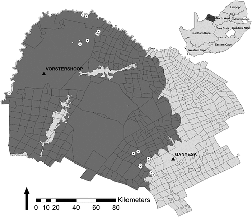
The study was conducted in the ranching area of the Kagisano-Molopo Local Municipality (in the following referred to as Molopo) of the North-West Province of South Africa (Fig. 1). The area is located in the south-eastern part of the Kalahari basin where the major rural land uses comprise large livestock farming and game farms for both hunting and ecotourism purposes.
|
The climate of the study area is semiarid. Rainfall occurs predominantly during the summer months from November to April, peaking in January. Mean annual precipitation ranges from 274 mm in the south-west of the study area [South African Weather Service (SAWS), weather data Severn (station 0428635 1), period 1981–2011] to 316 mm in the north-eastern regions [SAWS, weather data Bray (station 0541297 5), period 2000–2011], with an overall coefficient of variation of ~45%. The mean annual temperature for the Molopo is 19.1°C (Rutherford et al. 2006). The climatic conditions limit the agricultural potential in the Molopo, and the rangelands easily deteriorate if management does not accommodate the unpredictability of the seasonal climate, particularly rainfall.
The topography varies between 1000 and 1300 m above sea level and is characterised by undulating to flat sandy plains with no permanent rivers. Soils in the area are predominantly well drained Arenosols formed by aeolian Kalahari sands of recent age. They are usually more than 1.2 m deep (Rutherford et al. 2006).
The vegetation is known as the Molopo Bushveld (sensu Rutherford et al. 2006) and consists of open savanna to closed shrubland. Most common species found in the woody layer include Acacia erioloba, A. hebeclada and Boscia albitrunca, as well as the locally most serious increaser species A. mellifera, A. luederitzii, Dichrostachys cinerea, Grewia flava and Terminalia sericea. Abundant grasses include Aristida congesta, Eragrostis lehmanniana, Schmidtia kalahariensis and Stipagrostis uniplumis (Richter et al. 2001; Rutherford et al. 2006). The long-term grazing capacity for this vegetation type is ~10 ha LSU–1 (large stock unit) (Mostert et al. 1971 cited in Richter et al. 2001).
Data were collected on four commercially-managed cattle farms, two game farms and two communally-managed rangelands. Sampling sites on these farms were predefined in the PRACTICE project, testing an integrated and participatory environmental evaluation protocol in the Molopo (Harmse et al. 2013). Following the protocol, a total of 17 sampling sites (Fig. 1) were subjectively chosen by local farmers who were asked to indicate a rangeland in good and poor condition on their farmland. Criteria used by the farmers included, among others, abundance and composition of non-preferred woody species, grass species composition, standing biomass of grasses and accessibility for livestock. Field assessments covered a range of conditions spanning a gradient from open to heavily bush-encroached savanna.
Sampling design
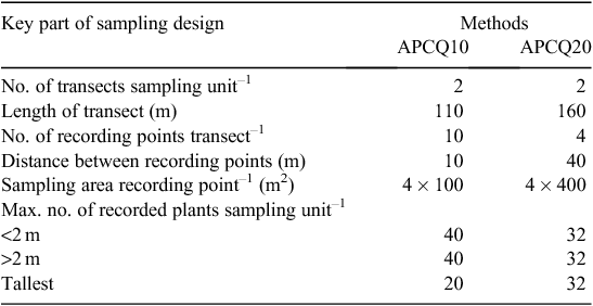
The first APCQ method tested follows Stuart-Hill (1989) with the addition of considering different height classes of shrubs and trees, which are recorded in a 10-m radius around recording points as described in Trollope et al. (2004). This APCQ method is referred to as the APCQ10 method in the present study. The second APCQ method resembles the method described by Trollope (2011), which was developed to obtain a more representative sample of tall shrubs and trees – which generally have a lower density in savanna ecosystems – and thus, an overall more balanced sample of different height classes. This method differs from APCQ10 method in several key ways (Table 1) including a 20-m sampling radius around recording points. For clarity, this APCQ method is referred to as the APCQ20 method in the present study.
|
At each site, data were collected in homogeneous vegetation stands along two parallel transects, which formed the sampling unit. The starting point of the first transect was determined at random and the second transect was laid out at a distance of 40 m in concordance with the sampling design of the APCQ20 method. Originally, the transect lines of the APCQ10 method were 25 m apart (Trollope et al. 2004). However, for better comparability and practicality both APCQ methods were tested on the same transect lines.
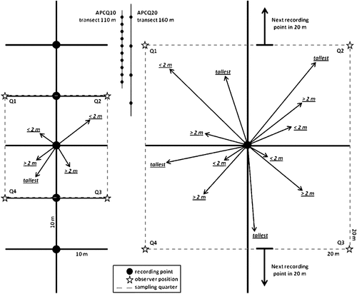
The transects of the APCQ10 method were 110 m in length, with 10 contiguous recording points at 10-m intervals (total of 20 recording points per sampling unit). The transects of the APCQ20 method were 160 m in length with 40 m between recording points (total of eight recording points per sampling site) (Fig. 2). Instead of sampling shrubs and trees growing exclusively within a radius of 10 and 20 m around each recording point [as described in Trollope et al. (2004) and Trollope (2011), respectively], at each recording point four quarters with side lengths of 10 m (APCQ10 method) and 20 m (APCQ20 method) were marked out (Fig. 2). This approach was found to be more practical and quicker than the use of a circular quadrat in considering the area of the whole quarter by positioning one observer in an outer corner of the quarter in order to decide if individual plants growing at the fringes were in or out the quarter (Fig. 2). Data recorded for woody individuals in each quarter include species, distance from recording point, and biometric characteristics (see below).
|
For the APCQ10 method, the distance to the nearest shrub or tree below 2 m in height was recorded in quarters 1 and 2, and the nearest shrub or tree above 2 m was recorded in quarters 3 and 4. In quarter 4, the tallest woody individual was also recorded if it differed from the nearest shrub or tree above 2 m. Quarters 1 and 2 of each recording point became quarters 3 and 4 of the following recording point, but due to the different height classes sampled no individual was recorded twice (Fig. 2). For the APCQ20 method, the nearest individual of the three height classes (i.e. <2 m; >2 m; tallest) was recorded in each quarter (Fig. 2). All distance measurements were from the recording point to the trunk or, in case of multi-stemmed plant individuals or ramets, the centre of the plant (group).
Mueller-Dombois and Ellenberg (1974) pointed out two general limitations when sampling the quarters: (1) an individual must be located in each quarter, and (2) an individual must not be measured twice, which may be problematic in sparsely wooded vegetation. Trollope et al. (2004) and Trollope (2011) suggested that, in cases where there are no trees or shrubs within the designated area around the recording point, zero plants should be recorded for the respective height class. However, this inevitably leads to a slight overestimation of tree density ha–1, because in open, sparsely wooded savanna types, fewer shrubs and trees are found within distances of 10 and 20 m, respectively, from the recording points, resulting in an overall lower average recording distance, which in turn implies a denser structure of the woody component. In order to reduce the error, plants growing left or right of the transect line up to a distance of 30 m were also considered if no suitable plants were found within the original quarters. This considerably increased the probability of recording a plant and better reflected the more open spacing of respective woody communities. Care was taken not to record the individuals twice, which could happen while sampling the second transect.
Biometric measurements and calculations
Data were recorded in late October 2012 after the onset of the first seasonal rains. The measurements of woody plant communities followed Smit (1989a) and were: (1) height of the tree or shrub, (2) height of maximum canopy diameter, (3) height of lowest browseable material (leaves or potential leaf-bearing stems), (4) two maximum canopy diameters perpendicular to each other, and (5) canopy diameter at height of lowest browseable material. Measurements were only made of live vegetation. Plastic poles 2 m in length and marked in 10-cm intervals were used for distance measurements from the recording points and direct measurements of plants. The height of large trees and the diameters of high canopies were estimated by placing one pole next to the tree and estimating the required dimension from a distance. In order that data could be compared and to minimise among-observer variance, all data were collected exclusively by the same team of two experienced ecologists. A third person recorded the measurements.
Four calculations were made to determine the condition of the woody layer:
-
Woody density [plants (P) ha–1] = 10 000 m2/D2, where D2 is the mean distance of the trees or shrubs from the recording points in square metres (Cottam and Curtis 1956). The density of shrubs and trees was calculated separately for each height class (i.e. <2 m, >2 m, tallest), with the total woody density being the sum of mean densities calculated for the three different height classes (Trollope 2011).
-
Phytomass of shrubs and trees was expressed as tree equivalents (TE) ha–1, defined as a woody individual 1.5 m tall (Teague et al. 1981). For each height class, the number of TE = n × h × 1.5−1, where n is the number of plants ha–1 and h is the mean height of the shrub or tree (m). Total phytomass is the sum of TE ha–1 calculated in the height classes (Trollope 2011).
-
The available browse was calculated as a function of the browsing potential of the shrubs and trees present, i.e. the number of woody species in a certain height class which were preferred by both domestic livestock (e.g. goats) and game. It was expressed in browsing units (BU) ha–1 and calculated by multiplying the phytomass (TE ha–1) in each height class by the proportion of preferred species. The height classes were ‘<2 m’ and ‘>2 m’; the latter was the sum of the height classes ‘>2 m’ and ‘tallest’ (Trollope 2011).
-
Browsing capacity (ha BU–1), i.e. productivity of the browseable portion of a unit of vegetation, was expressed as the area of land required to maintain a single animal unit over an extended number of years without deterioration to vegetation or soil (Trollope et al. 1990). It was calculated after Smit (2006) as d × (DM × f × r–1)–1, where d is the total number of days in a year (365), DM is the total leaf dry matter yield ha–1, f is the utilisation factor [the average 0.35 (35%) is commonly used] and r the daily DM required per browser animal [2.5% of body mass for a Kudu (140 kg), thus 3.5 kg DM day–1]. A leaf quantification technique [Biomass Estimates from Canopy Volume model (Smit 1989b)] was used to determine the DM yield of the woody component based on the volumetric measures listed above. The browsing capacities were calculated for both height classes because browser animal species, such as goats, impala, kudu and eland, are only able to utilise the available browse below 2 m, whereas larger browsers, such as giraffes, also utilise the ‘>2 m’ height class (Trollope 2011).
In addition, two measures of diversity were compared in the study: species richness (the total number of woody species encountered along the transects); and the Simpson diversity index (D = 1 – Σ Pi2, where Pi is the proportional frequency of a species i).
Statistical analyses
Data were analysed for the vegetation gradient from open to heavily bush-encroached savanna, and three density classes. The density classes were determined by grouping the sampling sites with the agglomerative hierarchical Ward’s clustering method based on Euclidean distances (Fielding 2007), using the calculated density data (trees ha–1) for the three height classes ‘<2 m’, ‘>2 m’ and ‘tallest’. This minimum-variance method considers the total sum of squared deviations from the mean of a cluster. Clusters are joined such that the smallest possible increase in the error sum of squares is produced (Fielding 2007). The clustering was performed separately for each of the two APCQ methods and the resulting dendrograms (available from the author) were compared with respect to the best match in clusters. This resulted in three density classes corresponding well with the local farmers’ perceptions of rangeland condition and with the researchers’ expert knowledge: open (rangeland condition good; mean of 367 trees ha–1; n = 7), dense (rangeland condition moderate to poor; mean of 1031 trees ha–1; n = 6), and encroached (rangeland condition very poor; mean of 3250 trees ha–1; n = 4).
General relationships between estimates of density and productivity variables and diversity measures obtained by the two APCQ methods were analysed using Spearman’s rank correlations (Quinn and Keough 2002) based on data of the whole density gradient. Differences in the performance of the APCQ methods along the gradient and in the three density classes were tested using the paired t-test as the two methods were applied at exactly the same location on the same day. While t-test-based comparisons of groups with equal sample sizes are quite robust to violations of the assumption of normally distributed populations, the assumption of equal variances and the presence of extreme values are more critical. Accordingly, prior application boxplots were examined with respect to symmetry of distributions and outliers, and data were log-transformed where necessary (Quinn and Keough 2002). If the distribution was still asymmetrical, the non-parametric Wilcoxon signed-rank test for paired observations based on an exact randomisation method was used (Quinn and Keough 2002). The precision of the results of the APCQ10 and APCQ20 methods was estimated by calculating coefficients of variation and significant differences determined by means of the two-tailed Fligner–Killeen test (Fligner and Killeen 1976).
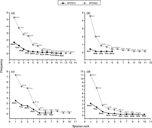
Due to the expected underestimation of tall shrubs and trees using the APCQ10 method, abundance patterns of species recorded in the height class ‘tallest’ by the APCQ10 and APCQ20 methods were visually compared using rank-frequency diagrams (Mouillot and Lepretre 2000). The diagrams display species frequencies (y-axis) against species ranks in descending order (x-axis) from most common (rank 1) to rarest (rank S; total species richness). The comparison of resulting curves depicts at a glance, rank, shifts of species between a common, intermediate and rare occurrence, as well as differences in species richness and evenness (steep curve = low evenness due to few dominant species) of the communities (Oldeland et al. 2010b).
All analyses were done using PAST v. 2.15 (Hammer et al. 2001). Only untransformed values are shown.
Results
Overall performance of methods along the density gradient
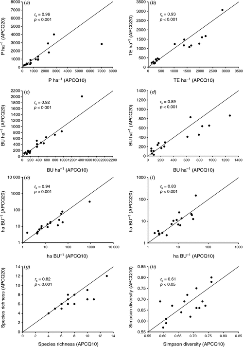
All structure and productivity estimates obtained with the two APCQ methods correlated very well along the whole density gradient (Fig. 3). The coefficients of variation for both APCQ methods were similar and the only significant differences in mean values were found in pair-wise comparisons of the diversity measures (Table 2). The APCQ20 method underestimated species richness (Fig. 3g) as significantly fewer species were detected when all height classes of shrubs and trees were lumped together (P < 0.01; Table 2). In contrast, the APCQ20 method detected significantly more ‘tallest’ species and individuals than the APCQ10 method, as shown by the greater species richness and a higher abundance-based Simpson diversity in that height class (P < 0.01; Table 2). For the latter, the correlation between both APCQ methods was found to be the weakest (Fig. 1h), which could also be deduced from the species frequency distributions of ‘tallest’ individuals along the whole density gradient. Respective rank-frequency curves depicted overall lower frequency values for ‘tallest’ species detected by the APCQ10 method than by the APCQ20 method (Fig. 4a).
|

|
|
Performance of methods in specific density classes
In open, dense and encroached savannas, no differences between the APCQ methods were found if all height classes were lumped together and in the height class ‘<2 m’, with the coefficients of variation indicating a similar precision for all density, productivity and diversity estimates (Table 2). In contrast, the performance of the APCQ methods differed for the height classes ‘>2 m’ and ‘tallest’ depending on the density structure of the woody community. While results for the height class ‘>2 m’ did not differ between APCQ10 and APCQ20 methods in the density class ‘open’ and ‘dense’, they slightly differed under encroached conditions: the APCQ20 method resulted in a significantly higher browsing capacity (P < 0.05), whereas the APCQ10 method resulted in a higher estimate for available browse (P < 0.01) (Table 2). In the height class ‘tallest’, a significantly higher species richness (P < 0.05), Simpson diversity (P < 0.05), woody density (P < 0.01) and phytomass (P < 0.01) were recorded using the APCQ20 method rather than the APCQ10 method in the density class ‘open’ (Table 2). This indicates that the APCQ10 method under-samples taller individuals in sparsely wooded savannas while the APCQ20 method increases the probability of recording one of the scattered growing tall trees or shrubs. This pattern is likely to account for the significantly lower coefficients of variation for woody density using the APCQ20 method (Table 2) because the APCQ10 method was found to be quite consistent in under-sampling ‘tallest’ plants (see below). In the density class ‘encroached’, the APCQ10 method indicated a significantly higher phytomass production (P < 0.01) of the tallest shrubs and trees than the APCQ20 method.
Species frequency distribution of tallest individuals
The comparison of the APCQ10 and APCQ20 methods, using rank-frequency curves for species recorded in the height class ‘tallest’, revealed different diversity and frequency patterns across the density classes (Fig. 4b–d). The shape of the curves displayed a diversity pattern of lower species richness for the APCQ10 method than the APCQ20 method [except for density class ‘encroached’ (Fig. 4d)] and overall lower frequency values, indicating a high evenness in species distribution (Fig. 4b, c). In contrast, the APCQ20 method revealed a higher species richness [except for ‘encroached’ (Fig. 4d)] and higher frequency values for all ‘tallest’ species recorded, showing that the APCQ10 method consistently under-sampled ‘tallest’ shrubs and trees (Fig. 4b–d). The species frequency distributions derived by the APCQ20 method indicated a lower evenness in the frequency pattern than those derived by the APCQ10 method with a steep initial slope (1–2 relatively abundant species), a few species of intermediate abundance and a long tail of rare species (Fig. 4b–d). In the density class ‘open’ most of these rare species were not detected by the APCQ10 method at all (Fig. 4b).
Discussion
Performance of APCQ methods
The suitability of the APCQ methods for describing the woody savanna component was found to be determined by the purpose of assessment, particularly if a discrimination of woody layers was relevant. If the aim is not to examine different height classes of shrubs and trees and the focus is on density and productivity parameters, the APCQ methods provide comparable results with similar precision, irrespective of the overall condition of the woody community. Thus, both APCQ methods can be applied for an assessment across woody communities of varying density structure – provided no subsequent analyses of different woody layers is conducted – and solely practical considerations may determine the choice of the method (see below). However, one of the strengths of the APCQ methods is their ability to allow for a height-stratified analysis of the woody layer. This is for many management and/or research purposes critical, as a more differentiated description of the condition of the woody savanna component is obtained.
Differences in density, productivity and diversity estimates
The separate examination of different height classes showed that the APCQ10 and the APCQ20 methods can result in different density, productivity and diversity estimates, depending on the density structure of the woody community. These differences were, however, largely restricted to the height classes ‘>2 m’ and ‘tallest’ in open savanna types. Although the APCQ10 method theoretically records more shrubs/trees per sampling unit (a total of 40 per height class versus 32 by the APCQ20 method; Table 1), the effective number is lower due to the underestimation of shrubs and trees above 2 m in height. It is evident that the APCQ20 method avoids under-sampling of larger shrubs and trees and, hence, precision in data assessment is increased in open savannas. This is illustrated by a better representation of the density, phytomass and diversity status of the woody layer in that density class. In addition, the rank-frequency diagrams clearly showed that applying the APCQ20 method detects an increased frequency of occurrence of a range of species in the height class ‘tallest’ than the APCQ10 method. These results suggest that the APCQ20 method indeed allows a more representative sampling of different woody height classes, and confirm Trollope’s (2011) adaptations for a more balanced quantification of the woody layer in range condition assessments. This is an important aspect for managers, especially on game ranches, where the composition of different height classes and the associated available phytomass determines the suitability of the woody layer for browser species. An assessment allowing a clearer differentiation between the three height classes, i.e. whose results are more representative, has direct implications for decision-making regarding stocking rates and mixture of game in a paddock.
The APCQ10 method under encroached conditions gave a significantly higher estimate of phytomass production and availability of preferred browse for woody plant species above 2 m than did the APCQ20 method. This may be because the heavily encroached woody communities were sporadically interspersed with open patches, which are more likely encountered along a 160-m transect (APCQ20 method) than along a 110-m transect (APCQ10 method). In these less dense patches, there is a lower phytomass production and potentially fewer species preferred by browsing animals. Therefore, it can be assumed that the APCQ10 method over-samples the woody layer in dense to encroached stands due to the combined effect of more recordings (eight more per height class than by the APCQ20 method) and increased likelihood of encompassing less environmental heterogeneity. The finding that variables, such as woody density and phytomass of shrubs below 2 m in height, tended to be generally higher when using the APCQ10 method (even if not significantly) support this assumption. It is, therefore, desirable to compare the APCQ methods with other methods to establish which one better deals with natural heterogeneity and better describes the real condition, respectively (see also below).
Differences in species frequency distributions
The rank-frequency diagrams provided further support for the APCQ20 method being the method giving a better representation of the species composition, diversity and commonness versus rarity in the height class ‘tallest’ of the woody layer. This was particularly true for open savannas, where the APCQ10 method implied rarity of actually common species, which leads to false conclusions, e.g. with respect to the age structure of the community, demographic patterns at the population level and/or the spread of increaser or invasive species. The ability to identify rare and common species, and to detect and trace occurring shifts in the population structure and community composition, is highly important for environmental management. For example, applying the APCQ10 method missed or underestimated the occurrence of already established mature individuals of typical increaser species, such as A. mellifera, D. cinerea and T. sericea, in the sampled open and dense rangelands (Fig. 4b, c). The same applied to important key species, such as A. erioloba, whose disappearance would indicate a critical shift in the ecosystem. Therefore, the APCQ20 method appears to be more suitable for monitoring open savanna vegetation and prioritising actions for sustainable range management.
Practical implications
The general impression of applying both APCQ methods in the Molopo Bushveld was that the underlying approach is practical and time-efficient for the quantification of the woody component of savanna vegetation. The APCQ methods require only a little expert knowledge and can be effectively conducted by a team of two people. The ability of the APCQ methods to generate repeatable results in combination with its simplicity and inexpensiveness make them suitable for a broad range of users. The greatest advantage of the APCQ methods is that they allow assessment of a variety of structural, compositional and productivity variables with a single assessment, as shown in the present study. The derived ecologically-based descriptions of the tree and shrub vegetation can help decision-making in range management and/or nature conservation. A practical example of this is provided by the vegetation monitoring developed and used on the Mun Ya Wana Private Game Reserve in the KwaZulu-Natal province of South Africa where the APCQ20 method is used for controlling the prescribed burning program and the stocking rate of browsing animals (Trollope et al. 2013). Plot-less distance methods like the APCQ methods are regarded as a credible ground-truth for remote-sensing products or aerial photographs (Dahdouh-Guebas and Koedam 2006; Puttick et al. 2011), making them a practical complementary tool in large-scale environmental assessments.
The systematic procedure for density measurements largely excludes an estimator bias. This is an advantage over fixed-area techniques in combination with ocular estimates, which lack precision (Godínez-Alvarez et al. 2009). Density estimates based on sampling techniques other than plot-less distance measures may be less practical than the APCQ methods. For example, belt transects have the disadvantage that they are unsuitable in dense vegetation due to the physical sampling effort of recording each plant within the sampling unit (Trollope et al. 2004; Puttick et al. 2011). Where the assessment is for inventory with the target being very scattered, large trees – such as A. erioloba or B. albitrunca, alternatives to the APCQ methods, such as plot-based assessments, are rather impractical. This is because sampling areas need to be large enough to also include a reasonable proportion of the scattered growing species; or a high number of smaller plots is needed, which is very labour-intensive (Engeman et al. 1994; Elzinga et al. 1998; Bullock 1999). In this regard, the PCQ methods offers increased sampling efficiency over fixed-area plots (Bryant et al. 2005; Dahdouh-Guebas and Koedam 2006).
A use-oriented contrast of the APCQ10 and APCQ20 methods shows that, despite an increased sampling intensity of plant individuals, the reduced number of recording points per sampling unit using the APCQ20 method allows a much faster assessment of condition in open savanna than the APCQ10 method. Conversely, while both APCQ10 and APCQ20 methods are simple to conduct, the APCQ10 method is the faster and much more practical in dense vegetation: the transect is shorter and quarters sampled only 100 m2 in size. This has clear advantages: in dense vegetation it is challenging to extend the transect tape in a straight line to avoid following ‘a path of least resistance’ (Puttick et al. 2011), thus having shorter distances is less time-consuming; and identifying the nearest plant of a certain height class in a closer range around the recoding point is much easier. In addition, the APCQ10 method may provide an advantage in fitting the sampling unit into the sampling site. If the site of concern is spatially restricted, shorter transects – or their equivalent in suitable segments – increase flexibility.
Accuracy of the APCQ methods
There is evidence from various studies that the APCQ20 method provides scientifically credible results. It has been tested quantitatively and under experimental conditions in different vegetation types of South Africa and shown to give realistic predictions of density and phytomass (Trollope et al. 2013), as well as realistic estimates of browsing capacities and formulations of stocking rates for goats and browsing game (Trollope 2011). Moreover, the APCQ20 method features an increased sampling intensity per recording point, which is a pre-requisite to address the inability of most plot-less distance methods to accurately deal with clumped plant distributions (Elzinga et al. 1998). The present study suggests that, except for the tallest plants in open savanna systems, similarly credible results can be obtained applying the APCQ10 method, as can also be inferred from the calculated coefficients of variation. However, precision is not readily related to accuracy. There was no opportunity to assess the actual density of the naturally occurring woody communities at the sampling sites, which would have been a suitable basis to contrast estimates derived from the two APCQ methods and evaluate their accuracy by the deviation from true values (Dahdouh-Guebas and Koedam 2006; Seefeldt and Booth 2006). Alternatively, testing the two APCQ methods against other well established sampling methods would allow evaluating them with respect to accuracy, representativeness and comparability of the quantitative descriptions of woody plant communities. For example, fixed-area plots can provide unbiased results for density, abundance and composition data (Bryant et al. 2005). Estimates based on data collected using belt transects would offer a close approximation of true values as each woody plant within the belt is recorded (e.g. Smit 1989a; Higgins et al. 2007; O’Connor and Chamane 2012). Although Trollope et al. (2013) recently showed, in a comparative study, a significant relationship between density (trees/shrubs ha–1) and phytomass (TE ha–1) recorded with the APCQ20 method versus total count data in the same sampling sites, the coefficient of determination at least for density was low (r2 = 36.2%). It should therefore be noted that the tested APCQ methods are effective techniques for assessing and monitoring vegetation for management purposes but may lack the accuracy necessary for certain scientific assessments. Similarly, Bryant et al. (2005) concluded that estimates of density, diversity and community structure, based on PCQ methods, should be interpreted with caution.
Conclusions
This comparative study has shown that the APCQ20 method avoids an under-sampling of larger shrubs and trees as observed using the APCQ10 method in open savanna sites, and results in a better representation of the density, phytomass and diversity status of the associated woody layer, as well as the frequency distribution of species. This advantage disappears as vegetation becomes denser. Then, the APCQ10 method provides similar results to that of the APCQ20 method, particularly in encroached sites. From a practical point of view, the APCQ10 method has a range of advantages in dense vegetation, where restricted space impedes effective data collection. It is concluded that the APCQ20 method should be used to quantify open savanna communities and that the APCQ10 is more suitable in dense stands of more than ~1200 TE ha–1.
Overall, the two APCQ methods investigated provide effective techniques for assessing and monitoring the condition of woody layers in semiarid savannas for management purposes. Their simplicity also allows for landholder self-assessment. The data, that are gathered, suit a range of applications for farmers, environmental consultants and game managers. Despite the mentioned biases inherent to plot-less distance methods, they are frequently and often uncritically used in research. Therefore, the accuracy of both APCQ methods still needs to be investigated in comparison to other assessment methods in different savanna types of varying condition.
Acknowledgements
The authors thank the land users and farm managers for providing access to their properties, as well as their support during data collection. Anthony Pressland, John Milne and an anonymous reviewer gave valuable comments on an earlier version of this manuscript. The study was partly conducted within the framework of the PRACTICE project sponsored by the European Commission grant GA226818.
References
Barrett, A. S., and Brown, L. R. (2012). A novel method for estimating tree dimensions and calculating canopy volume using digital photography. African Journal of Range & Forage Science 29, 153–156.| A novel method for estimating tree dimensions and calculating canopy volume using digital photography.Crossref | GoogleScholarGoogle Scholar |
Bhattachan, A., D’Odorico, P., Baddock, M. C., Zobeck, T. M., Okin, G. S., and Cassar, N. (2012). The Southern Kalahari: a potential new dust source in the Southern Hemisphere? Environmental Research Letters 7, 024001.
| The Southern Kalahari: a potential new dust source in the Southern Hemisphere?Crossref | GoogleScholarGoogle Scholar |
Bryant, D. M., Ducey, M. J., Innes, J. C., Lee, T. D., Eckert, R. T., and Zarin, D. J. (2005). Forest community analysis and the point-centered quarter method. Plant Ecology 175, 193–203.
| Forest community analysis and the point-centered quarter method.Crossref | GoogleScholarGoogle Scholar |
Bullock, J. (1999). Plants. In: ‘Ecological Census Techniques. A Handbook’. (Ed. W. J. Sutherland.) pp. 111–138. (Cambridge University Press: Cambridge, UK.)
Cottam, G., and Curtis, J. T. (1956). The use of distance measures in phytosociological sampling. Ecology 37, 451–460.
| The use of distance measures in phytosociological sampling.Crossref | GoogleScholarGoogle Scholar |
Dahdouh-Guebas, F., and Koedam, N. (2006). Empirical estimate of the reliability of the use of the Point-Centered Quarter Method (PCQM): solutions to ambiguous field situations and description of the PCQM+ protocol. Forest Ecology and Management 228, 1–18.
| Empirical estimate of the reliability of the use of the Point-Centered Quarter Method (PCQM): solutions to ambiguous field situations and description of the PCQM+ protocol.Crossref | GoogleScholarGoogle Scholar |
Dougill, A. J., Thomas, D. S. G., and Heathwaite, A. L. (1999). Environmental change in the Kalahari: integrated land degradation studies for non-equilibrium dryland environments. Annals of the Association of American Geographers 89, 420–442.
| Environmental change in the Kalahari: integrated land degradation studies for non-equilibrium dryland environments.Crossref | GoogleScholarGoogle Scholar |
Elzinga, C. L., Salzer, D. W., and Willoughby, J. W. (1998). ‘Measuring and Monitoring Plant Populations.’ BLM/RS/ST-98/005+1730. (Bureau of Land Management: Denver, CO.)
Engeman, R. M., Sugihara, R. T., Pank, L. F., and Dusenberry, W. E. (1994). A comparison of plot-less density estimators using Monte Carlo simulation. Ecology 75, 1769–1779.
| A comparison of plot-less density estimators using Monte Carlo simulation.Crossref | GoogleScholarGoogle Scholar |
Fensham, R. J., and Fairfax, R. J. (2003). Assessing woody vegetation cover change in north-west Australian savanna using aerial photography. International Journal of Wildland Fire 12, 359–367.
| Assessing woody vegetation cover change in north-west Australian savanna using aerial photography.Crossref | GoogleScholarGoogle Scholar |
Fielding, A. H. (2007). ‘Cluster and Classification Techniques for the Biosciences.’ (Cambridge University Press: Cambridge, UK.)
Fligner, M. A., and Killeen, T. J. (1976). Distribution-free two sample tests for scale. Journal of the American Statistical Association 71, 210–213.
| Distribution-free two sample tests for scale.Crossref | GoogleScholarGoogle Scholar |
Fraser, E. D. G., Dougill, A. J., Mabee, W. E., Reed, M., and McAlpine, P. (2006). Bottom up and top down: analysis of participatory processes for sustainability indicator identification as a pathway to community empowerment and sustainable environmental management. Journal of Environmental Management 78, 114–127.
| Bottom up and top down: analysis of participatory processes for sustainability indicator identification as a pathway to community empowerment and sustainable environmental management.Crossref | GoogleScholarGoogle Scholar |
Gibbons, P., and Freudenberger, D. (2006). An overview of methods used to assess vegetation condition at the scale of the site. Ecological Management & Restoration 7, S10–S17.
| An overview of methods used to assess vegetation condition at the scale of the site.Crossref | GoogleScholarGoogle Scholar |
Godínez-Alvarez, H., Herrick, J. E., Mattocks, M., Toledo, D., and Van Zee, J. (2009). Comparison of three vegetation monitoring methods: their relative utility for ecological assessment and monitoring. Ecological Indicators 9, 1001–1008.
| Comparison of three vegetation monitoring methods: their relative utility for ecological assessment and monitoring.Crossref | GoogleScholarGoogle Scholar |
Hammer, Ø., Harper, D. A. T., and Ryan, P. D. (2001). PAST: Paleontological Statistics Software Package for Education and Data Analysis. Palaeontologia Electronica 4, .
Harmse, C. J., Dreber, N., Kellner, K., and Kong, T. M. (2013). Linking farmer knowledge and biophysical data to evaluate actions for land degradation mitigation in savanna rangelands of the Molopo, South Africa. In: ‘Revitalising Grasslands to Sustain our Communities. Proceedings of the 22nd International Grassland Congress’. Sydney, NSW, 15–19 September 2013. (Eds D. L. Michalk, G. D. Millar, W. B. Badgery and K. M. Broadfoot.) pp. 1128–1131. (New South Wales Department of Primary Industry: Orange, NSW.)
Higgins, S. I., Bond, W. J., February, E. C., Bronn, A., Euston-Brown, D. I. W., Enslin, B., Govender, N., Rademan, L., O’Regan, S., Potgieter, A. L. F., Scheiter, S., Sowry, R., Trollope, L., and Trollope, W. S. W. (2007). Effects of four decades of fire manipulation on woody vegetation structure in savanna. Ecology 88, 1119–1125.
| Effects of four decades of fire manipulation on woody vegetation structure in savanna.Crossref | GoogleScholarGoogle Scholar | 17536398PubMed |
Joubert, D., Smit, G. N., and Hoffman, M. T. (2013). The influence of rainfall, competition and predation on seed production, germination and establishment of an encroaching Acacia in an arid Namibian savanna. Journal of Arid Environments 91, 7–13.
| The influence of rainfall, competition and predation on seed production, germination and establishment of an encroaching Acacia in an arid Namibian savanna.Crossref | GoogleScholarGoogle Scholar |
Kgosikoma, O. E., Harvie, B. A., and Mojeremane, W. (2012). Bush encroachment in relation to rangeland management systems and environmental conditions in Kalahari ecosystem of Botswana. African Journal of Agricultural Research 7, 2312–2319.
| Bush encroachment in relation to rangeland management systems and environmental conditions in Kalahari ecosystem of Botswana.Crossref | GoogleScholarGoogle Scholar |
Lamacraft, R. R., Friedel, M. H., and Chewings, V. H. (1983). Comparison of distance-based density estimates for some arid rangeland vegetation. Australian Journal of Ecology 8, 181–187.
| Comparison of distance-based density estimates for some arid rangeland vegetation.Crossref | GoogleScholarGoogle Scholar |
Mark, A. F., and Esler, A. E. (1970). An assessment of the point-centred quarter method of plot-less sampling in some New Zealand forests. Proceedings of the New Zealand Ecological Society 17, 106–110.
Moleele, N. M., and Mainah, J. (2003). Resource use conflicts: the future of the Kalahari ecosystem. Journal of Arid Environments 54, 405–423.
| Resource use conflicts: the future of the Kalahari ecosystem.Crossref | GoogleScholarGoogle Scholar |
Morgenthal, T. L., and Kellner, K. (2008). ‘Operational Manual for FIXMOVE. Proposed methodology to sample vegetation for the national fixed site monitoring programme.’ Project GW51/069, Report No. GW/A/2008/. (National Department of Agriculture: Pretoria, Gauteng, South Africa.)
Mouillot, D., and Lepretre, A. (2000). Introduction of Relative Abundance Distribution (RAD) indices, estimated from the Rank-Frequency Diagrams (RFD), to assess changes in community diversity. Environmental Monitoring and Assessment 63, 279–295.
| Introduction of Relative Abundance Distribution (RAD) indices, estimated from the Rank-Frequency Diagrams (RFD), to assess changes in community diversity.Crossref | GoogleScholarGoogle Scholar |
Mueller-Dombois, D., and Ellenberg, H. (1974). ‘Aims and Methods of Vegetation Ecology.’ (John Wiley & Sons: New York.)
Mukwada, G. (2009). The influence of anthropogenic phenomena and contingency in tree resource distribution in Mufurudzi resettlement area, Zimbabwe. Journal for Nature Conservation 17, 1–14.
| The influence of anthropogenic phenomena and contingency in tree resource distribution in Mufurudzi resettlement area, Zimbabwe.Crossref | GoogleScholarGoogle Scholar |
O’Connor, T. G., and Chamane, S. C. (2012). Bush clump succession in grassland in the Kei Road region of the Eastern Cape, South Africa. African Journal of Range & Forage Science 29, 133–146.
| Bush clump succession in grassland in the Kei Road region of the Eastern Cape, South Africa.Crossref | GoogleScholarGoogle Scholar |
Oldeland, J., Dorigo, W., Wesuls, D., and Jürgens, N. (2010a). Mapping bush encroaching species by seasonal differences in hyperspectral imagery. Remote Sensing 2, 1416–1438.
| Mapping bush encroaching species by seasonal differences in hyperspectral imagery.Crossref | GoogleScholarGoogle Scholar |
Oldeland, J., Dreber, N., and Wesuls, D. (2010b). Diversity measures in comparative rangeland studies: application and advantages of species abundance distributions and diversity profiles. Dinteria 31, 50–66.
Puttick, J. R., Hoffman, M. T., and Gambiza, J. (2011). Historical and recent land-use impacts on the vegetation of Bathurst, a municipal commonage in the Eastern Cape, South Africa. African Journal of Range & Forage Science 28, 9–20.
| Historical and recent land-use impacts on the vegetation of Bathurst, a municipal commonage in the Eastern Cape, South Africa.Crossref | GoogleScholarGoogle Scholar |
Quinn, G. P., and Keough, M. J. (2002). ‘Experimental Design and Data Analysis for Biologists.’ (Cambridge University Press: Cambridge, UK.)
Richter, C. G. F., Snyman, H. A., and Smit, G. N. (2001). The influence of tree density on the grass layer of three semi-arid savanna types of southern Africa. African Journal of Range & Forage Science 18, 103–109.
| The influence of tree density on the grass layer of three semi-arid savanna types of southern Africa.Crossref | GoogleScholarGoogle Scholar |
Rutherford, M. C., and Powrie, L. W. (2010). Severely degraded dunes of the southern Kalahari: local extinction, persistence and natural re-establishment of plants. African Journal of Ecology 48, 930–938.
| Severely degraded dunes of the southern Kalahari: local extinction, persistence and natural re-establishment of plants.Crossref | GoogleScholarGoogle Scholar |
Rutherford, M. C., Mucina, L., Lötter, M. C., Bredenkamp, G. J., Smit, J. H. L., Scott-Shaw, C. R., Hoare, D. B., Goodman, P. S., Bezuidenhout, H., Scott, L., Ellis, F., Powrie, L. W., Siebert, F., Mostert, T. H., Henning, B. J., Venter, C. E., Camp, K. G. T., Siebert, S. J., Matthews, W. S., Burrows, J. E., Dobson, L., van Rooyen, N., Schmidt, E., Winter, P. J. D., du Preez, P. J., Ward, R. A., Williamson, S., and Hurter, P. J. H. (2006). Savanna biome. In: ‘The Vegetation of South Africa, Lesotho and Swaziland’. (Eds L. Mucina and M. C. Rutherford.) pp. 439–538. (Strelitzia 19, South African National Biodiversity Institute: Pretoria, South Africa.)
Sankaran, M., Hanan, N. P., Scholes, R. J., Ratnam, J., Augustine, D. J., Cade, B. J., Gignoux, J., Higgins, S. I., Le Roux, X., Ludwig, F., Ardo, J., Banyikwa, F., Bronn, A., Bucini, G., Caylor, K. K., Coughenour, M. B., Diouf, A., Ekaya, W., Feral, C. J., February, E. C., Frost, P. G. H., Hiernaux, P., Hrabar, H., Metzger, K. L., Prins, H. H. T., Ringrose, S., Sea, W., Tews, J., Worden, J., and Zambatis, N. (2005). Determinants of woody cover in African savannas. Nature 438, 846–849.
| Determinants of woody cover in African savannas.Crossref | GoogleScholarGoogle Scholar | 1:CAS:528:DC%2BD2MXht1ynsrrP&md5=7c457f9f2f5cd24abdbc76aa83f4d967CAS | 16341012PubMed |
Scholes, R. J., Dowty, P. R., Caylor, K., Parsons, D. A. B., Frost, P. G. H., and Shugart, H. H. (2002). Trends in savanna structure and composition along an aridity gradient in the Kalahari. Journal of Vegetation Science 13, 419–428.
| Trends in savanna structure and composition along an aridity gradient in the Kalahari.Crossref | GoogleScholarGoogle Scholar |
Seefeldt, S. S., and Booth, D. T. (2006). Measuring plant cover in Sagebrush steppe rangelands: a comparison of methods. Environmental Management 37, 703–711.
| Measuring plant cover in Sagebrush steppe rangelands: a comparison of methods.Crossref | GoogleScholarGoogle Scholar | 16485162PubMed |
Skarpe, C. (1990). Shrub layer dynamics under different herbivore densities in an arid savanna, Botswana. Journal of Applied Ecology 27, 873–885.
| Shrub layer dynamics under different herbivore densities in an arid savanna, Botswana.Crossref | GoogleScholarGoogle Scholar |
Smet, M., and Ward, D. (2005). A comparison of the effects of different rangeland management systems on plant species composition, diversity and vegetation structure in a semi-arid savanna. African Journal of Range & Forage Science 22, 59–71.
| A comparison of the effects of different rangeland management systems on plant species composition, diversity and vegetation structure in a semi-arid savanna.Crossref | GoogleScholarGoogle Scholar |
Smit, G. N. (1989a). Quantitative description of woody plant communities: Part I. An approach. Journal of the Grassland Society of Southern Africa 6, 186–191.
| Quantitative description of woody plant communities: Part I. An approach.Crossref | GoogleScholarGoogle Scholar |
Smit, G. N. (1989b). Quantitative description of woody plant communities: Part II. Computerized calculation procedure. Journal of the Grassland Society of Southern Africa 6, 192–194.
| Quantitative description of woody plant communities: Part II. Computerized calculation procedure.Crossref | GoogleScholarGoogle Scholar |
Smit, G. N. (2004). An approach to tree thinning to structure southern African savannas for long-term restoration from bush-encroachment. Journal of Environmental Management 71, 179–191.
| An approach to tree thinning to structure southern African savannas for long-term restoration from bush-encroachment.Crossref | GoogleScholarGoogle Scholar | 1:STN:280:DC%2BD2c3jslGrtA%3D%3D&md5=14242dad0efe03e5687dd59f74d16764CAS | 15135951PubMed |
Smit, G. N. (2006). Calculation of grazing capacity and browse capacity for game species. In: ‘Game Ranching in Central South Africa’. (Ed. F. Schutte.) pp. 18–28. (Charmainé Albers Design & Marketing: Brandfort, South Africa.)
Stohlgren, T. J., Bull, K. A., and Otsuki, Y. (1998). Comparison of rangeland vegetation sampling techniques in the Central Grasslands. Journal of Range Management 51, 164–172.
| Comparison of rangeland vegetation sampling techniques in the Central Grasslands.Crossref | GoogleScholarGoogle Scholar |
Stuart-Hill, G. C. (1989). Assessing the condition/ecological status of Valley Bushveld. In: ‘Veld Management in the Eastern Cape’. (Eds J. E. Danckwerts and W. R. Teague.) pp. 103–108. (Department of Agriculture and Water Supply: Stutterheim, Eastern Cape Region, South Africa.)
Teague, W. R., Trollope, W. S. W., and Aucamp, A. J. (1981). Veld management in the semi-arid bush-grass communities of the Eastern Cape. Proceedings of the Annual Congresses of the Grassland Society of Southern Africa 16, 23–28.
| Veld management in the semi-arid bush-grass communities of the Eastern Cape.Crossref | GoogleScholarGoogle Scholar |
Trollope, W. S. W. (2011). ‘Assessment of Veld Condition using the Adapted Centred Quarter Method.’ Special Report. (Working on Fire International: Nelspruit, South Africa.)
Trollope, W. S. W., Trollope, L. A., and Bosch, O. J. H. (1990). Veld and pasture management terminology in southern Africa. Journal of the Grassland Society of Southern Africa 7, 52–61.
| Veld and pasture management terminology in southern Africa.Crossref | GoogleScholarGoogle Scholar |
Trollope, W. S. W., Van den Broeck, D., Brown, D., Webber, L., and Nibe, S. (2004). Assessment of veld condition in the thicket communities of the Great Fish River Reserve in the Eastern Cape Province of South Africa. In: ‘Proceedings of the 2004 Thicket Forum’. Addo, RSA, 26–27 May 2004. (Ed. S. L. Wilson.) pp. 91–105. (Centre for African Conservation Ecology: Port Elizabeth, South Africa.)
Trollope, W. S. W., Trollope, L. A., Goode, R., de Bruyn, P., and van den Broeck, D. (2013). ‘Assessment of Veld Condition Using the Adapted Point Centred Quarter Method for Bush Surveys.’ Special Report. (Working On Fire International: Nelspruit, South Africa.)
Ward, D., and Esler, K. J. (2011). What are the effects of substrate and grass removal on recruitment of Acacia mellifera seedlings in a semi-arid environment? Plant Ecology 212, 245–250.
| What are the effects of substrate and grass removal on recruitment of Acacia mellifera seedlings in a semi-arid environment?Crossref | GoogleScholarGoogle Scholar |