

Assessment of vulnerability to climate change in the Inner Mongolia steppe at a county scale from 1980 to 2009
Tingting Yang A , Peng Li A , Xinhong Wu A , Xiangyang Hou A D , Pengtao Liu B and Guozheng Yao CA Institute of Grassland Research, Chinese Academy of Agricultural Sciences, Hohhot, 010010, China.
B Ecology and Agrimeteorology Centre of Inner Mongolia, Hohhot, 010051, China.
C College of Ecology and Environmental Science, Inner Mongolia Agricultural University, Hohhot, 010018, China.
D Corresponding author. Email: houxy16@126.com
The Rangeland Journal 36(6) 545-555 https://doi.org/10.1071/RJ14011
Submitted: 13 May 2013 Accepted: 11 October 2014 Published: 11 November 2014
Journal Compilation © Australian Rangeland Society 2014
Abstract
Most of Inner Mongolia is covered with natural grassland and is highly sensitive to global climate change because of the physical geography, the highly variable climate, and the complicated socioeconomic conditions. The climate is generally wetter in the east becoming drier towards the west of the region. Using a Pressure-State-Response model to select climate-related assessment indicators, a vulnerability assessment to climate change framework of counties in Inner Mongolia was built, which included three layers and 17 indicators. Climate change vulnerability of eight counties in the steppe area of Inner Mongolia was assessed from 1980 to 2009. The results showed that in the past 30 years, climate change vulnerability of eight counties has decreased with the decrease more pronounced after 2000. The lowest value for vulnerability was in 2008. The vulnerability of the western region was higher than that of the eastern region. Counties with a desert ecological system had a higher vulnerability than counties with steppe. Under the background of exposure increasing and sensitivity slightly decreasing, a continuing significant improvement in adaptive capacity is the key reason for a reduction invulnerability of the Inner Mongolia steppe area to climate change. The volatility of the climate on an inter-annual scale can cause changes in vulnerability between years. With the development of the rural economy and increases in national investment in the environment, the vulnerability of the Inner Mongolian steppe has been significantly reduced, but, overall, the vulnerability remains high. Most of the counties are moderately vulnerable, some counties are seriously vulnerable, even extremely vulnerable, and strong measures need to be adopted to strengthen the ability to adapt to climate change.
Additional keywords: adaptive capacity, deserts, exposure, grasslands, sensitivity, steppe area.
Introduction
The study of climate change is important because of its impacts on human and natural systems (Milly et al. 2005; Yuan et al. 2013). The United Nations Intergovernmental Panel on Climate Change (IPCC) forecast that future changes would include increases in temperature, increased temporal and spatial variation in precipitation, and more frequent climatic disasters (IPCC 2007; Qin and Luo 2008). According to these forecasts, the average temperature may rise by 1.3°C (1.1–1.4°C) between 2010 and 2060 (Davis et al. 2010). Forecast climate change in China has the same features as the global trends, but the change in the main indicators is slightly greater (Zhai and Zou 2005; Ding et al. 2012). In the past 50 years, a rise in temperature has occurred in the north of China, where the rise in mean annual temperature in Inner Mongolia reached 0.8°C 10 year–1, that is, annual temperature has risen by more than 4°C in the past 50 years (Qin et al. 2005). Against the background of this rise in temperature, a variety of frequent extreme weather events and meteorological disasters have had far-reaching and significant impacts on the natural environment and the socioeconomic development of China (Yin et al. 2012). In 2006, high temperatures and drought events hit Sichuan and Chongqing provinces, 2800 million people were affected, and the direct economic loss reached 21.6 billion Yuan (Xiong 2013). In 2008, southern China suffered freezing rain and heavy snow, which led to serious consequences. In the winter of 2009, northern China suffered extreme drought and in some areas, there was no precipitation during the whole of the winter (Chen 2012). Then, in 2010, five provinces in south-western China suffered critical water shortages, which had rarely happened before, and at the same time, northern China suffered severe low temperatures in the spring (Chen 2012).
The natural rangelands in northern China extend over an area of 313 million ha, accounting for 79.7% of the total area of the natural rangelands in China. These rangelands are important in maintaining national and regional ecological security, promoting regional economic development and ensuring social stability (Wu et al. 2009). Over the last century, large changes have taken place in the temperate grassland ecosystems in northern China at different levels of social and biological organisation. These have brought about serious and adverse effects on the economic and social development of these steppe regions. These effects vary with the strength of the regional adaptive capacity to cope with climate change (Zhang et al. 2008). Therefore, it is important to evaluate the vulnerability to climate change in the Northern China steppe and to explore ways to reduce it (Blaikie et al. 1994; Hou 2010; Mechler et al. 2010; Yuan et al. 2013).
Historically, different indicators have been applied to evaluate vulnerability to climate change. Christensen et al. (2004) examined the vulnerability of grassland vegetation in Inner Mongolia to climate change and grazing using an ecosystem model. Using the Vulnerability-resilience Indicator Prototype (VRIP) model, Brenkert and Malone (2005) evaluated the vulnerability of India and Indian states to climate change. He et al. (2012) assessed the vulnerability of the areas of China that could be affected by freezing weather conditions from 2001 to 2020 and from 2001 to 2050 using seven indices. Pandey and Jha (2012) assessed the vulnerability to climate change to communities using a climate Vulnerability index taking rural Lower Himalaya in India as an example. Yuan et al. (2013) evaluated China’s regional vulnerability to drought and proposed some policy recommendations to alleviate the impacts of drought under climate change. Kim and Chung (2013) used various multi-criteria decision-making (MCDM) methods to assess the vulnerability of a water-resource system in South Korea to climate change, which were performed at a provincial level. Polsky et al. (2007) built vulnerability assessments using a global-change model, facilitating the comparison of assessments with dissimilar measures. Sun et al. (2010) analysed the vulnerability to climate change of ecosystems in the Shiyang River Basin by building an assessment index system of 13 indicators. Liu and Lu (2008) built a numerical evaluation model of eco-environment vulnerability using spatial principal component analysis and Geographical Information System (GIS) technologies, and analysed the eco-environmental vulnerability in the Hulunbuir steppe. Hou et al. (2012) studied the vulnerability to drought in the eastern Qinghai Province using the Analytic Hierarchy Process (AHP) and a mathematic classification method, based on 20 indices of meteorology, agriculture and the economy in 22 counties and districts. Yu et al. (2008) developed a new quantitative approach to assess the vulnerability of terrestrial ecosystems based on an ecosystem process model with two aspects: vegetation changes and ecosystem function changes.
To estimate the vulnerability to climate change in the Inner Mongolia steppes, we adopted a Pressure-State-Response (P-S-R) model, which involved building an index system based on indicators which had obvious causality (Wang 2010). From the perspective of system theory, the vulnerability to climate changes in steppes conforms to a P-S-R model, that is, external factors put pressure on the system, stimulate and change the status of the system, then produce positive or negative impacts, which illustrate the vulnerability or the adaptive capacity of the ecosystem. Specific processes can be as follows: economic development, as a driver, makes a demand on the natural resources of a grassland area and causes overgrazing, desertification and grassland degradation, thus producing stresses on economic development. In addition, economic developments also affect the sensitivity and adaptive capacity of the system. Therefore, we adopted a P-S-R model to devise a Vulnerability index to climate change in steppe areas.
Although vulnerability has been conceptualised in many different ways, the scientific use of this concept has its roots in the existence of natural hazards and reflects the interactions between humans and the environment (Füssel 2007; Polsky et al. 2007). Basically, regional vulnerability to climate change was considered as a function of exposure, sensitivity and adaptive capacity (Brenkert and Malone 2005; IPCC 2007; Pandey and Jha 2012; Liu et al. 2013). Therefore, there is a need to understand the relationships among these three elements and reduce regional vulnerability to climate change by altering those in which change is possible.
In this paper, based on the P-S-R model, an index of the vulnerability to climate change for China’s northern steppes was built, which involves three layers (target, component and indicator). Based on previous research, the building of the index system was guided by the following principles: scientific, representativeness, typicality, operability, general adaptability, independence and comparability.
-
Scientific: the index system should be built based on science and encompasses the essential objectivity.
-
Representativeness: the index system should reflect key elements including vulnerability to climate change.
-
Typicality: the construction of the index system should highlight the characteristics of climate change in rangeland areas.
-
Operability: indicators should be easy to implement in practice and easy to operate and understand. Relevant data should be accessible.
-
General adaptability: the name and algorithms of the indicators should be international far as possible.
-
Independence and comparability: the indicators should be independent.
The main purpose of this study was to develop an integrated index to evaluate the vulnerability to climate change of the Inner Mongolia steppe at a county scale and propose mitigation strategies for future climate change. The integrated index containing exposure, sensitivity and adaptive capacity was calculated using the AHP, which revealed the vulnerability to climate change. Finally, we discussed the available mitigation strategies for areas with different vulnerabilities to climate change.
Materials and methods
Study area
Inner Mongolia has a total area of 1 183 000 km2, accounting for 12.3% of China’s land area (Fig. 1). It has a temperate continental monsoon climate with strong winds and large variations in temperature. Rainfall generally decreases and temperature increases from north-east to south-west (Shi et al. 1989). The average annual precipitation declines from 450 mm in the eastern part to 50 mm in the western part (Niu 2001). On the contrary, the annual average temperature increases, being −4°C in the east part, and 8°C in the west part. There is a gradation in the vegetation from zonal forest in the east, to meadow steppe, typical steppe, desert steppe and desert in the west.

|
The rangelands of Inner Mongolia, with a variety of grassland types, account for 22% of the total area of rangelands in northern China, comprising the main body of the temperate grassland in the country (Zhang et al. 2009). Eight counties in Inner Mongolia were selected as the area of the case study to assess the vulnerability to climate change. These counties were Zhenglan Banner (ZLQ), Xianghuang Banner (XHQ), Dong Ujimqin Banner (DWQ), Xilinhot (XLHT), Sonid Youqi (SYQ), Sonid Zuoqi (SZQ), Alxa Zuoqi (AZQ), Alxa Youqi (AYQ) (Fig. 1). The first four counties are in the typical steppe zone, the last two in the desert region and the remaining two are in the desert steppes.
Building the index system
Components of vulnerability to climate change
Vulnerability is defined as ‘the degree that a natural or social system is vulnerable to suffer or does not have the ability to cope with the adverse effects of climate change (including climate variability and extreme weather events)’ (IPCC 2001). Vulnerability is a function of exposure, sensitivity and adaptive capacity (IPCC 2007; Polsky et al. 2007) and depends on the relationships among these three dimensions (Yuan et al. 2013), which can be described as follows (Pandey and Jha 2012):

The relationship among all three independent elements is not specified, and is governed by local circumstances. Vulnerability is a positive function of the system’s exposure and sensitivity, and a negative function of the system’s adaptive capacity (Ford and Smit 2004).
According to this interpretation, the composition of county vulnerability to climate change is based on the regional vulnerability to drought (Yuan et al. 2013) and a vulnerability scoping diagram (Polsky et al. 2007).
Selection of indicators and building the assessment system
We used the following approach for producing an integrated set of indicators. First, the authors collected 124 related indicators from the relevant literature. Second, 20 scientists discussed and developed a list of principles for vulnerability to climate change. Third, these scientists selected key indicators from the 124 suggested indicators. The scientists were from different fields including grassland science, water and soil conservation, ecology and environmental science. If more than 33% of the scientists believed an indicator to be unimportant, this indicator was eliminated. Thirty-five indicators were eliminated, for example heavy rain days, industrial input-output ratio, shelterbelt ratios, forest cover, and the proportion of water-saving irrigation. In addition, 48 indicators were eliminated because information on them was difficult to obtain, such as critical period of variability of precipitation, accumulated temperature change in the key growth period, non-agricultural water consumption rate, the degree of salinity, soil bulk density, species diversity index and the loss rate of industrial resources. A further 31 indicators, which were similar to one another, were eliminated, for example relating to precipitation and aboveground biomass. Finally, 17 key indicators for Inner Mongolia steppe vulnerability to climate change were identified (Table 1).

|
Exposure indicators Exposure is location-dependent and refers to the nature and extent of climate changes of variables such as temperature, precipitation, extreme weather events and sea level (Brenkert and Malone 2005). The following five indicators were included: aridity, relative variability of precipitation, annual precipitation, accumulated temperature and number of disasters per year (including snowstorms, drought, sandstorms and biological hazards).
Sensitivity indicators Sensitivity refers to how systems might be affected by climate change (Brenkert and Malone 2005). For example, how much might biomass, vegetation cover, or carrying capacity change? In this study, four aspects, vegetation, land use, production and population were taken into account using the following eight sensitivity indicators: water resources, land cover type, vegetation cover, aboveground biomass, proportion of shifting sandy land, the proportion of the population engaged in the agricultural sector, the Engel coefficient, and optimum carrying capacity (Table 1). The Engel coefficient is the proportion spent on food of total consumer spending.
Adaptive capacity indicators Adaptive capacity refers to the capability of a society to adapt to climate changes so that welfare is maintained or any gain maximised and loss minimised (Brenkert and Malone 2005). Three aspects were identified, namely industrial structure, per capita income and total financial investment. Correspondingly, the measurement indicators were the Gross Domestic Production per capita, the proportion of non-agricultural output value, net income per capita of herdsman and financial investment (Table 1).
Data sources and calculations
Meteorological data - Meteorological data in this paper are from the China Meteorological Data Sharing Service (CMDSS 2009) and Inner Mongolia Meteorological Bureau (Inner Mongolia Autonomous Region Bureau of Statistics 1980–2010); each station lists daily data from 1980 to 2009. The major indicators acquired were daily mean temperature (°C), daily precipitation (mm), annual precipitation (mm) and annual accumulated temperature (≥0°C), which were used to calculate precipitation variability (Q) and aridity (K). The equations used were as follows:

where Ri is actual precipitation in a period of the i year (mm) and R is the average precipitation in the same period of several years.
Aridity (K) was calculated using the following equation (Meng et al. 2004; Sun et al. 2010):

where r is the annual average precipitation and Σ ≥ 10°C is annual accumulated temperature of more than 10°C.
Socioeconomic data - Socioeconomic data were from the Statistical Yearbook (Inner Mongolia Autonomous Region Bureau of Statistics 1980–2010) for all counties between 1980 and 2009, such as Gross Domestic Product per capita, the proportion of non-agricultural output value, the net income per capita of herdsmen, financial investment, water resources, agriculture and animal husbandry, the proportion of the population, and the Engel coefficient.
Vegetation coverage and biomass - Satellite imagery data (NOAA/AVHRR NDVI) from 1981 to 2006 with a spatial resolution of 8 by 8 km and a time resolution of 2 weeks were used and converted into a time step of 1 month. Monthly MODIS NDVI data from 2000 to 2009 with a spatial resolution of 1 km were also used. Based on MODIS and NOAA data for 2000–06, the average NDVI was calculated. A productivity model of different grassland types in Inner Mongolia was used (Zhang et al. 2008). The average aboveground biomass of every county was calculated and the proportion of shifting sandy land was obtained from the vegetation classification.
Vegetation cover (VFC) was estimated using the relationship between VFC and NDVI; the equation used was as follows (Xu et al. 2005):

where, for the study area, NDVImin is the NDVI minimum value of bare land, NDVImax is the NDVI maximum value for vegetation and C is the maximum vegetation cover.
Aboveground biomass of vegetation (Y, g m–2) was estimated using the following equation (Zhang et al. 2008):

Other data
Number of disasters was obtained by analysing data and information from newspapers and the Meteorological Bureau. Vegetation types were from China’s grassland types maps at 1 : 4 000 000. Optimum carrying capacity per ha (S) and per capita (Sper) were calculated from the following equations:


where A is available grassland area (ha), Y is grassland yield in period (kg ha–2), E is the proportion of grassland utilised (%), D is the number of grazing days, I is daily intake of one sheep unit (kg DM day–1) and P is human population of the county.
Weights of indicators
The AHP was used in this study to determine the weights of the indicators (Saaty 1980). The AHP is a method of analysis that combines qualitative and quantitative factors to quantify the relative importance of each factor. The development of an evaluation matrix helps identify the weight and relative importance of every indicator. The weight of every indicator was obtained from 15 well known scientists in the field of grassland science, water and soil conservation, ecology and environmental science. The assessment matrix was constructed using the approach described in Table 2.
|
First, a judgment matrix of A-B, B1-C, B2-C and B3-C was built based on Table 1. The weight of every expert was used to build the judgment matrix and to calculate the weight of every indicator, then the average of the weight obtained from the 15 experts was used as the weight of each indicator.
The method of geometric means was used to calculate the judgment matrix (Deng et al. 2012). First, the root values ( ) and Eigenvectors (Wi) were calculated from the following equations:


where αij is all elements in every row of matrix, n is the order of the judgment matrix. Eigenvectors (Wi) were the final weight vectors of the assessment matrix, that is, the weight of indicators in the criterion layer.
The ratio of random consistency (CR) was also calculated to identify the consistency of the results of the analytic hierarchy process. If CR <0.1, the consistency of the results was acceptable, and the distribution of weighting vectors was acceptable.

where RI is the proportional coefficient, which is related with the order(n) of judgment matrix (Table 3) and CI is the coincidence indicator.
|

where B is the value of judgment matrix and is the maximum feature root in the judgment matrix.
All assessment matrices in this study passed the consistency test, and the CR <0.1, which means that the consistency of the results was acceptable. Finally, the weights of the indicators were ranked and calculated, and the final weights of the 17 indicators were obtained (Table 4). These indicators were normalised to restrict the range from 0 to 1.

|
Calculation of vulnerability index to climate change
There were no uniform evaluation criteria for the vulnerability assessment to climate change; each of the indicators was measured on a different scale, so the original data needed to be standardised through an index in order to improve the comparability of indicators and time segments. The measured values of the various indicators were transformed into a dimensionless standard value. The index was formed using the following approach for each component:

where Bi is standard scores of each indicator, Xi is the indicator value of a component for a county, and Xmax and Xmin are the maximum and minimum values of a component.
After standardisation for all indicators, each component (Exposure, Sensitivity, and Adaptive capacity) was calculated as follows:

where Ak is one of the components for the climate change vulnerability index (CCVI), Bi are standard scores of each indicator, and m is the number of indicators in each component.
Then, the CCVI was calculated as follows:

where CCVI is the climate change vulnerability index, Ak is the score of each component, and Wj is the weight of each component.
Statistical methods
Correlation analyses in this paper were completed using the software SPSS 10.0 (Huang et al. 2001).
Results
Exposure indicator
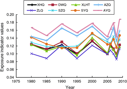
Different counties had different values for the exposure indicator from 1980 to 2009 (Fig. 2). County AYQ had the highest value of the exposure indicator, ranging from 0.143 to 0.190 whereas the values in county AZQ were lower than those in county AYQ (range 0.132–0.170), throughout this period, and counties SZQ and SYQ, which are adjacent to one another, had similar exposure indicators, with the highest value in 2000 (0.150) and the lowest value in 2008 (0.116). The inter-annual variation in exposure indicators in counties DWQ, XLHT and XHQ were similar, with the highest and lowest values being in 2000 and 2008, respectively. The exposure indicators in county ZLQ were the lowest of the eight counties, especially in the 1980s. Counties AZQ and AYQ, in the arid desert area, belong to the warm temperate zone located in western Inner Mongolia, had the highest values of the exposure indicator. Counties SZQ and SYQ, located in the middle of Inner Mongolia, belong to transition ecosystems from desert to steppe, and their values for the exposure indicator were intermediate. Counties ZLQ, XHQ and XLHT in the east of the region had the lowest values of the exposure indicator, and have a semiarid continental climate. County DWQ had an intermediate exposure indicator and has a semiarid and semi-humid continental climate.
|
Exposure indicators of the same area in different years were different, but from 1980 to 2009, there were no significant differences between years. Exposure indicators for XHQ, DWQ and XLHT counties showed a slight decrease over the years of the study whereas exposure indicators of the other counties showed a slight increase.
The relationships between the values of each exposure indicator and the values of its five components were analysed (Table 5), and showed that the number of disasters (P < 0.01) was the only component with a highly significant correlation.

|
Sensitivity indicator
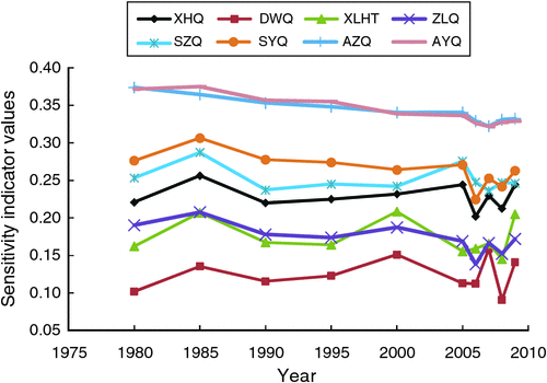
The values of the sensitivity indicator of DWQ county showed a slight increase from 1980 to 2009 whereas the values for the other seven counties declined, in particular for counties AZQ and AYQ (Fig. 3). The highest values were found in AZQ and AYQ counties, followed by counties SZQ and SYQ with DWQ having the lowest values. Values for the Sensitivity index were higher in the western part of the region than in the eastern part of the region.
|
Values for the Sensitivity index for the same vegetation types in adjacent counties were different, such as SYQ and SZQ counties, but the values for the Sensitivity index differed due to different values for the optimum carrying capacity. For the four counties of typical steppe, the differences in values of the Sensitivity index were due to the following indicators: water resources, the proportion of agricultural population and optimum carrying capacity.
The correlations between the values of the components of the Sensitivity index and the values of the Sensitivity index (Table 6) show that, for counties XHQ, DWQ, XLHT and SZQ, the Sensitivity index was highly significantly correlated with VFC and aboveground biomass (P < 0.01) for county ZLQ, and with aboveground biomass (P < 0.05). For county SYQ, there were significant correlations with the proportion of shifting sandy areas, the proportion of agricultural population and the Engel coefficient. For counties AZQ and AYQ, the Sensitivity index had highly significant correlations with the proportion of agricultural population, the Engel coefficient, and the optimal carrying capacity per capita.

|
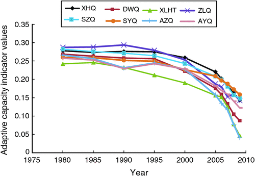
Adaptive capacity indicator
The values of the adaptive capacity indicator in the eight counties showed a significant reduction (the smaller the value the greater the adaptive capacity) from 1980 to 2009, particularly over the past few years of the period. The significant increases in adaptive capacity (reductions in the indicators) mainly came from increases in financial investment, the growth of the Gross Domestic Product per capita, increases in net income per capita, and increases in the proportion of non-agricultural output value. XLHT had the lowest value of the adaptive capacity indicator (i.e. the highest capacity) (Fig. 4). In 1980, the differences in the values for adaptive capacity of the eight counties were not great, but by 2009, the gap had significantly increased. The XLHT and AZQ counties had the largest decreases in the values of adaptive capacity indicator (i.e. the largest increases in adaptive capacity), which are the seats of government.
|
The relationship between the values of adaptive capacity indicator and the four component indicators (Table 7) show that adaptive capacity has highly significant correlation with Gross Domestic Product per capita, proportion of non-agricultural output value, net income per capita and financial investment.

|
Vulnerability
The vulnerability indicators to climate change of eight counties in Inner Mongolia decreased from 1980 to 2009 especially after the year 2000, with the lowest value in 2008 (Table 8). The vulnerability of the western part of the region was higher than in the eastern part. Counties with desert vegetation had the highest values for vulnerability, followed by counties with desert steppe vegetation; the lowest value was for counties with typical steppe. For counties with the same vegetation type, the vulnerability of neighbouring counties was similar.

|
Against the background of the Exposure index increasing and the Sensitivity index slightly decreasing, the continuing significant increase in adaptive capacity is the key reason for a reduction in vulnerability to climate change of the steppe area.
Classification of vulnerability
According to classification criteria of vulnerability (Table 9), vulnerability to climate change of the eight counties in Inner Mongolia from 1980 to 2009 was classified into five categories. The results in Table 8 show that three counties (DWQ, XLHT and ZLQ) belong to the moderate vulnerability category; two counties (SZQ and SYQ) belong to the serious vulnerability category; and a further two counties (AZQ and AYQ) belong to the extreme vulnerability category, which is located in the western part of the region. In addition, the classification of vulnerability of the county XHQ is between moderate and serious.

|
Analysis of the cause of vulnerability variations
Exposure, Sensitivity, and Adaptation indices were examined to analyse the causes of variations in vulnerability to climate change in eight different counties of the Inner Mongolia steppe. The results show that the trends in the exposure and sensitivity indices in the past 30 years fluctuated whereas the trend in adaptive capacity showed a decline. The relationships between vulnerability and 17 indicators (Table 10), showed that six indicators were significantly and positively related to vulnerability, and these were aboveground biomass, VFC, land cover types, proportion of shifting sandy land, water resources, and net income per capita of herdsmen.

|
Discussion
This study found that the counties in the western, more arid parts of Inner Mongolia are the most vulnerable to climate change. Similar results were found with more widespread studies where the more vulnerable regions to climate change were found in the north and west areas of China, and the most highly vulnerable ecosystems were found to be distributed in north-western China, Inner Mongolia, and some areas of northern and north-eastern China (Liu 1995; Zhao and Zhang 1998; Yu et al. 2008). The vulnerable ecosystems were mainly scattered in transition eco-zones and grassland-desert ecosystems in north-western China (Yu et al. 2008). Sun et al. (2010) assessed the vulnerability to climate change of ecosystems in the Shiyang River Basin using the comprehensive index analysis. Ecosystems appear extremely vulnerable to climate change, where it is extremely arid, where the desert steppes are dominant and the adaptability to climate change is quite limited.
Other studies, using quite different methodologies, also reached similar conclusions to this study. Wang et al. (2005) built a regional ecological Vulnerability index using remote-sensing images as the basic source of information. Tao and Zhao (2002) built an ecological Vulnerability index taking the Hexi Corridor in Gansu as an example. Some other regional studies have also shown that China’s vulnerable ecological areas are mainly distributed in the western arid region, the Loess Plateau, and the Tibetan Plateau (Li et al. 2005).
Assessment of vulnerability to climate change in the Inner Mongolian steppe area provides decision-making and scientific support to policy-making. In order to improve the adaptive capacity to climate change, and to avoid the adverse effect of climate change on the society, ecology and environment in this region, we need to combine ecological and environmental protection with a strategy for dealing with climate change, through adaptation and mitigation. Based on the main findings of the above assessment, the following suggestions are put forward.
For areas of moderate vulnerability (counties DWQ, ZLQ and XLHT), ecological management and vegetation restoration should be used to reduce vulnerability, and financial investment increased to improve adaptive ability, thereby reducing the vulnerability. For county XHQ, between moderate and serious vulnerability, the following strategies should be adopted: increase financial investment, implement ecological compensation mechanisms, strictly control the number of livestock and implement ecological management projects, to improve the environment. For seriously vulnerable areas, such as counties SZQ and SYQ, ecological management should aim to control shifting sand movement and increase VFC. Financial investment should also be increased, and population transfer should be considered to reduce the pressure on grasslands. For extreme vulnerability areas, such as counties AZQ and AYQ, where the natural conditions are extremely harsh, ecological protection and development should be restricted, together with continued strengthening of national policy and funding support. There is also the need to construct lines of ecological defence to manage the source of dust storms. At the same time, industry structure to control the proportion of the population in agriculture should be considered.
Conclusion
In this paper, an assessment framework of vulnerability to climate change for the steppe area in northern China was built, which included three layers and 17 indices. A Vulnerability index was used to represent integrated vulnerability to climate change for the steppe area of northern China, taking eight counties of different grassland types in Inner Mongolia as examples. Integrated vulnerability over a 30-year time interval was calculated to identify and evaluate key issues and key areas of climate change vulnerability in the region. It was found:
-
The Vulnerability index showed a decreasing trend over time. Vulnerability before the year 2000 was higher than that after the year of 2000, with the lowest value appearing in 2008.
-
Overall, the Inner Mongolia steppe region is still a sensitive and vulnerable area to climate change. Among the eight counties, three counties showed moderate vulnerability, two counties showed serious vulnerability and two counties showed extreme vulnerability, with another one between moderate and serious vulnerability. The vulnerability of the western part of the region was higher than that of the eastern region.
-
Against the background of exposure increasing and sensitivity slightly decreasing, the continuing significant increase in adaptive capacity is the key reason for vulnerability to climate change decreasing in the steppe area. Specifically, the main elements impacting on vulnerability of the Inner Mongolia steppe include VFC, aboveground biomass, vegetation types, proportion of shifting sandy land, water resources, the net income per capita of herdsmen and financial investment.
-
The adaptive capacity of XLHT and AZQ counties was higher than that of the other counties.
Acknowledgements
We thank the editors and two anonymous reviewers of The Rangeland Journal for their thoughtful comments, which helped in improving the manuscripts. The authors also thank Pengtao Liu and Guozheng Yao for their help in the calculation of the weights and in data processing. This study was financially supported by The National Key Basis Research Program of China (2014CB138806), The Important National Natural Science Foundation of China (70933004), The Basic Research Expenses Special Funds of the Central Public Welfare Scientific Research Institutes (1610332014028), The National Natural Science Foundation of China (71103185, 71311120089) and The Natural Science Foundation of Inner Mongolia (2014BS0331).
References
Blaikie, P., Cannon, T., and Wisner, B. (1994). ‘At Risk: Natural Hazards, People’s Vulnerability, and Disasters.’ (Routledge: London, UK.)Brenkert, A. L., and Malone, E. L. (2005). Modeling vulnerability and resilience to climate change: a case study of India and Indian states. Climatic Change 72, 57–102.
| Modeling vulnerability and resilience to climate change: a case study of India and Indian states.Crossref | GoogleScholarGoogle Scholar | 1:CAS:528:DC%2BD2MXhtVyisr%2FE&md5=e0efab263371551e6e993a9e58badbc7CAS |
Chen, D. L. (2012). Study on China’s major agricultural meteorological disaster forecasting under the background of climate change. Science and Technology Review 30, 3.
Christensen, L., Coughenour, M. B., Ellis, J. E., and Chen, Z. Z. (2004). Vulnerability of the Asian typical steppe to grazing and climate change. Climatic Change 63, 351–368.
| Vulnerability of the Asian typical steppe to grazing and climate change.Crossref | GoogleScholarGoogle Scholar | 1:CAS:528:DC%2BD2cXhsl2ns7g%3D&md5=d21cce45d4d2f4f47f938dc8b606d012CAS |
CMDSS (2009). Available at: http://cdc.cma.gov.cn/home.do (accessed 16 June 2014).
Davis, A. J., Caldeira, K., and Matthews, H. D. (2010). Future CO2 emissions and climate change from existing energy infrastructure. Science 329, 1330–1333.
| Future CO2 emissions and climate change from existing energy infrastructure.Crossref | GoogleScholarGoogle Scholar | 1:CAS:528:DC%2BC3cXhtFajs7rI&md5=2fddf38d7d88eda1e70b3c5ebe5ebb87CAS |
Deng, X., Li, J. M., and Zeng, H. J. (2012). Research on computation methods of AHP weight vector and its applications. Mathematics in Practice and Theory 7, 93–100.
Ding, Y., Hou, X. Y., Leonid, U., Wu, X. H., Yin, Y. T., Li, X. L., and Yun, X. J. (2012). An overview of climate change of temperate grassland and its impacts on vegetation. Chinese Agricultural Science Bulletin 28, 310–316.
Ford, J. D., and Smit, B. (2004). A framework for assessing the vulnerability of communities in the Canadian Arctic to risks associated with climate change. Arctic 57, 398–400.
| A framework for assessing the vulnerability of communities in the Canadian Arctic to risks associated with climate change.Crossref | GoogleScholarGoogle Scholar |
Füssel, H. M. (2007). Vulnerability: a generally applicable conceptual framework for climate change research. Global Environmental Change 17, 155–167.
| Vulnerability: a generally applicable conceptual framework for climate change research.Crossref | GoogleScholarGoogle Scholar |
He, Y., Wu, Y. F., and Liu, Q. F. (2012). Vulnerability assessment of areas affected by Chinese cryospheric changes in future climate change scenarios. Chinese Science Bulletin 57, 4784–4790.
| Vulnerability assessment of areas affected by Chinese cryospheric changes in future climate change scenarios.Crossref | GoogleScholarGoogle Scholar |
Hou, X. Y. (2010). Making great efforts to write a large composition based on science and technique. Chinese Journal of Grassland 32, 1–5.
Hou, G. L., Xiao, J. Y., and Li, S. M. (2012). Vulnerability assessment of drought based on climate change: a case study of eastern Qinghai Province. Journal of Natural Disasters 21, 163–168.
Huang, H., Luo, Y. F., and Chen, Z. Y. (2001). ‘SPASS 10.0 for Windows Statistical Analysis.’ (Posts and Telecom Press: Beijing, China.) [In Chinese]
Inner Mongolia Autonomous Region Bureau of Statistics (1980–2010). ‘Inner Mongolia Statistical Yearbook.’ (China Statistics Press: Beijing, China.) [In Chinese]
IPCC (2001). ‘Climate Change 2001: Synthesis Report. A Contribution of Working Groups I, II, and III to the Third Assessment Report of the Intergovernmental Panel on Climate Change.’ (Cambridge University Press: Cambridge, UK.)
IPCC (2007). ‘Climate Change: the Physical Science Basis.’ Contribution of Working Group I to the Fourth Assessment Report of the Intergovernmental Panel on Climate Change [R]. (Cambridge University Press: Cambridge, UK.)
Kim, Y., and Chung, E.-S. (2013). Assessing climate change vulnerability with group multi-criteria decision making approaches. Climatic Change 121, 301–315.
| Assessing climate change vulnerability with group multi-criteria decision making approaches.Crossref | GoogleScholarGoogle Scholar |
Li, K. R., Cao, M. K., Yu, L., and Wu, S. H. (2005). Assessment of vulnerability of natural ecosystems in China under the changing climate. Geographical Research 5, 653–663.
Liu, Y. H. (1995). Classification and indicator system of critical environment in China. In: ‘Synthesis Renovation and Resume of Eco-environment’. (Eds G. J. Zhao, Y. H. Liu and M. Zhao.) pp. 8–17. (Beijing Science and Technology Press: Beijing, China.) [In Chinese]
Liu, D. X., and Lu, X. S. (2008). Evaluation of eco-environmental vulnerability of grassland in Hulunbeier steppe. Journal of China Agricultural University 13, 48–54.
Liu, X. Q., Wang, Y. L., Peng, J., Braimoh, A. K., and Yin, H. (2013). Assessing vulnerability to drought based on exposure, sensitivity and adaptive capacity: a case study in middle Inner Mongolia of China. Chinese Geographical Science 23, 13–25.
| Assessing vulnerability to drought based on exposure, sensitivity and adaptive capacity: a case study in middle Inner Mongolia of China.Crossref | GoogleScholarGoogle Scholar |
Mechler, R., Hochrainer, S., Aaheim, A., Salen, H., and Wreford, A. (2010). Modeling economic impacts and adaptation to extreme events: insights from European case studies. Mitigation and Adaptation Strategies for Global Change 15, 737–762.
| Modeling economic impacts and adaptation to extreme events: insights from European case studies.Crossref | GoogleScholarGoogle Scholar |
Meng, M., Ni, J., and Zhang, Z. G. (2004). Aridity index and its applications in Geo-ecological study. Acta Phytoecologica Sinica 28, 853–861.
Milly, P. C. D., Dunne, K. A., and Vecchia, A. V. (2005). Global pattern of trends in stream flow and water availability in a changing climate. Nature 438, 347–350.
| Global pattern of trends in stream flow and water availability in a changing climate.Crossref | GoogleScholarGoogle Scholar | 1:CAS:528:DC%2BD2MXht1WksbfJ&md5=7322d4766cef6351bd57cbb8f70d40c1CAS |
Niu, J. M. (2001). Impacts prediction of climate change on distribution and production of grassland in Inner Mongolia. Acta Agrestia Sinica 9, 277–282.
Pandey, R., and Jha, S. (2012). Climate vulnerability index-measure of climate change vulnerability to communities: a case of rural Lower Himalaya, India. Mitigation and Adaptation Strategies for Global Change 17, 487–506.
| Climate vulnerability index-measure of climate change vulnerability to communities: a case of rural Lower Himalaya, India.Crossref | GoogleScholarGoogle Scholar |
Polsky, C., Neff, R., and Yarnal, B. (2007). Building comparable global change vulnerability assessments: the vulnerability scoping diagram. Global Environmental Change 17, 472–485.
| Building comparable global change vulnerability assessments: the vulnerability scoping diagram.Crossref | GoogleScholarGoogle Scholar |
Qin, D. H., and Luo, Y. (2008). The reason for global climate change and its future trend. Impact of Science on Society 2, 16–21.
Qin, D. H., Ding, Y. H., and Su, J. L. (2005). Assessment of climate and environment changes in China (I): climate and environment changes in China and their projection. Advances in Climate Change Research 1, 4–9.
Saaty, T. L. (1980). ‘The Analytic Hierarchy Process.’ (McGraw-Hill: New York.)
Shi, Y. Z., Shi, Y. H., and Bai, Z. F. (1989). ‘Geography in Inner Mongolia.’ (Inner Mongolia People’s Publishing House: Hohhot, China.)
Sun, L. D., Yue, L., and Guo, H. (2010). Assessment on climate change vulnerability of ecosystems in the Shiyang River Basin. Arid Zone Research 27, 204–210.
| Assessment on climate change vulnerability of ecosystems in the Shiyang River Basin.Crossref | GoogleScholarGoogle Scholar |
Tao, X. D., and Zhao, H. J. (2002). Study on the vulnerability assessment, restoration and regeneration of ecology in the Hexi Corridor. Arid Zone Research 19, 7–11.
Wang, Y. (2010). Theories and methodologies of climate change vulnerability comprehensive assessment and their application in an urban area case study in an estuary city of Shanghai in China. PhD Thesis, Fudan University, Shanghai, China. [In Chinese]
Wang, J. Y., Zhao, G. X., and Du, C. X. (2005). Analysis on the regional ecological environment vulnerability based on the information of spatial structure of landscapes – a case study in Kenli Country located in the Yellow River Delta. Arid Zone Research 22, 317–321.
| 1:CAS:528:DC%2BD28XmtFKgtQ%3D%3D&md5=000be1f5e5154486d3180e2f2eb3c5a4CAS |
Wu, M. X., Qian, S., and Hou, Y. Y. (2009). Estimation of forage yield in Northern China based on NDVI data. Transactions of the CSAE 25, 149–155.
Xiong, Y. J. (2013). Advances of research about high temperature events and its meteorological disaster in China. Journal of Arid Meteorology 13, 194–198.
Xu, H. M., Gao, Q. Z., and Zhao, Y. L. (2005). Vegetation cover and its dynamics in the Changchuan watershed on soft rock area of Middle Yellow River, Inner Mongolia. Journal of Desert Research 25, 880–885.
Yin, S. Y., Huang, C. C., and Cha, X. C. (2012). On extreme flood disasters and global climate change: a case study of flooding of the Hanjiang River and Weihe River. Journal of Natural Disasters 21, 41–48.
Yu, L., Cao, M. K., and Tao, B. (2008). Quantitative assessment of the vulnerability of terrestrial ecosystems of China to climate change based on potential vegetation. Journal of Plant Ecology 32, 521–530.
Yuan, X. C., Wang, Q., Wang, K., Wang, B., Jin, J. L., and Wei, Y. M. (2013). China’s regional vulnerability to drought and its mitigation strategies under climate change: data envelopment analysis and analytic hierarchy process integrated approach. Mitigation and Adaptation Strategies for Global Change , .
| China’s regional vulnerability to drought and its mitigation strategies under climate change: data envelopment analysis and analytic hierarchy process integrated approach.Crossref | GoogleScholarGoogle Scholar |
Zhai, P. M., and Zou, X. K. (2005). Changes in temperature and precipitation and their impacts on drought in China during 1951–2003. Advances in Climate Change Research 1, 16–18.
Zhang, L. Y., Zhang, J. X., Sai, Y. J. Y., Bao, H. X., Tan, J. G., and Guo, Z. Z. (2008). Remote sensing monitoring model for grassland vegetation biomass monitoring in typical steppe – a case study from Xilinguole. Pratacultural Science 25, 31–34.
Zhang, H. B., Tang, H. J., Yang, G. X., Li, G., Cjen, B. R., and Xin, X. P. (2009). Changes of spatial-temporal characteristics based on MODIS NDVI data in Inner Mongolia grassland from 2000–2008. Transactions of the CSAE 25, 168–175.
Zhao, Y. L., and Zhang, L. J. (1998). Study on method of quantitative assessment of fragile environment. Scientia Geographica Sinica 18, 73–79.