

Breaking the wildfire cycle: progressive fire management can shift fire regimes and improve ecosystem condition. A case study from a large conservation reserve in northern Australia
Lea Ezzy A *A Department of Environment and Science, Queensland Parks and Wildlife Service, Townsville, Qld 4810, Australia.
The Rangeland Journal - https://doi.org/10.1071/RJ22021
Submitted: 30 March 2022 Accepted: 31 August 2022 Published online: 20 September 2022
© 2022 The Author(s) (or their employer(s)). Published by CSIRO Publishing on behalf of the Australian Rangeland Society. This is an open access article distributed under the Creative Commons Attribution-NonCommercial-NoDerivatives 4.0 International License (CC BY-NC-ND)
Abstract
Extensive late dry season fires in northern Australia have long been considered detrimental to biodiversity conservation, pastoral production and other cultural and landscape values. Fire management programs in these landscapes typically aim to shift the fire regime from wildfires occurring predominately in the late dry season (LDS), when they tend to be extensive and destructive, to prescribed burns in the early dry season (EDS), when fires are generally smaller and less intensive. The intent is to create heterogeneity in vegetation age classes, reduce the scale of LDS fires and, in doing so, retain long-unburnt vegetation, a critical asset for biodiversity in a flammable landscape. Boodjamulla National Park, in Queensland’s Gulf Country, experienced a cycle of large LDS wildfires every 5 years for most of its history as a pastoral property and park until a progressive EDS burning program was introduced. Although there is limited information for defining the ideal fire regime for spinifex (Triodia spp.) rangelands, this program has improved a range of spatial metrics which the Queensland Parks and Wildlife Service (QPWS) believes can only benefit biodiversity; these include decreased annual and LDS area burnt; a greater number of small burnt patches; shorter distances between recently burnt and long-unburnt spinifex; and, consequently, a greater area of long-unburnt spinifex embedded in the mosaic across the landscape. There has been an improvement in the ecological parameters of these landscapes, as well as the protection and persistence of fire-sensitive vegetation communities and species, because of the burn program.
Keywords: fire management, heterogeneity, prescribed burning, spatial metrics, spinifex.
Introduction
Fire is a key natural ecological process in the tropical savannas and rangelands of northern Australia (Bowman et al. 2010; Russell-Smith et al. 2020). The tropical climate is typically characterised by high wet-season rainfall followed by an extended dry season, resulting in a cycle of prolific summer vegetation growth and then rapid curing, creating ideal fire conditions (Russell-Smith and Edwards 2006). Fire management in Australia was a core cultural and land management activity conducted by Aboriginal people over many thousands of years, and the ecology and patterning of wildlife naturally evolved to be resilient to this management (Andersen et al. 2005). However, fire in northern Australia was largely unmanaged after European colonisation, characterised by a shift from smaller early dry-season (EDS) burns to a regime of frequent, large, and high-intensity wildfires in the late dry season (LDS; Gill et al. 2003; Russell-Smith et al. 2009). This change caused substantial negative effects on the flora and fauna of this significant ecoregion (Andersen 2021).
Fire regimes are defined by their frequency, intensity, scale, season, and type (Gill et al. 2003). LDS wildfires are typically intense, and have the most negative effect when they occur frequently. These impacts include a reduction of spatial and temporal habitat heterogeneity, including the loss of unburnt refugia (e.g. Franklin 1999; Crowley et al. 2009) and structural and floristic changes resulting in decreased resources for wildlife, and then subsequent wildlife population declines (Woinarski and Legge 2013). Frequent, intense LDS wildfires can also promote invasive species that respond quickly to disturbance or are disturbance tolerant (Rossiter et al. 2003; van Wilgen et al. 2010; Alba et al. 2015), reduce cultural values and pastoral production, and increase greenhouse-gas emissions (Corey et al. 2020).
Fire management on conservation land in northern Australia typically aims to reduce LDS wildfires and re-establish the patchy EDS fires more characteristic of Aboriginal cultural burning (Andersen et al. 2005). The heterogeneity or patchiness resulting from an EDS fire regime promotes structural complexity beneficial to tropical savanna fauna (Price et al. 2005). Landscapes that contain a mix of different-aged vegetation, including older age classes, are considered to represent high ecological-condition ecosystems (Radford et al. 2020). The patchiness of EDS burns and the reduction in dry-season wildfires increase the total unburnt area, which provides measurable biodiversity benefits (Andersen et al. 2005; Radford et al. 2020; Shaw et al. 2021). Such benefits are often defined using Geographic Information Systems (GIS)-derived metrics, with an underlying ecological rationale to demonstrate improved fire management (Price et al. 2005; Legge et al. 2011; Evans and Russell-Smith 2020; Edwards et al. 2021). A recognition of the importance of this strategic shift in fire management has led to well resourced broad-scale burning programs across large tracts of northern Australia, often using aircraft-mounted incendiary machines (Legge et al. 2011; Edwards et al. 2021).
In this study, I review 21 years of fire management in a large (>380 000 ha) and significant conservation reserve (Boodjamulla National Park) in the tropical savannas of Queensland, Australia. At gazettal of the reserve in 1984, a 5-year cycle of large-scale and high-intensity LDS wildfires was entrenched, resulting in young, even-aged, contiguous stands of the very fire-prone spinifex grass (Trioda spp.), the dominant vegetation type of the reserve (Wright et al. 2021). These extensive LDS wildfires caused significant environmental and financial cost. For example, in November 2006, a LDS wildfire that burnt over 60% of the reserve cost the QPWS approximately AU$180 000 to manage (L. Ezzy, unpubl. data). Similarly, an assessment of the vegetation of the reserve after this wildfire rated the ecological parameters of both fire-adapted and fire-sensitive vegetation communities as critical (Melzer et al. 2019). The fire regime was also implicated in the decline of the endangered Carpentarian grasswren (Amytornis dorotheae), a species dependent on old unburnt spinifex and areas of fire refuge (Harrington et al. 2011; Harrington and Murphy 2015). The fire management guidelines for this region recommend fire-free intervals between 4 and 10 years, a retention of some unburnt areas for 10–20 years, and widespread, but patchy, EDS fire regimes (Queensland Government 2013).
Appropriate fire regimes are critical for conservation in fire-prone environments, especially when extreme weather patterns caused by climate change can create catastrophic fires and severe impacts on biodiversity (Ward et al. 2020). I present the history and outcome of a long-term landscape-scale prescribed burn program at Boodjamulla National Park, the aim of which was to break the cycle of large LDS wildfire. This paper assesses the burn program and documents the change in the fire regime at Boodjamulla between 2000 and 2020, by using an associated improvement in key spatial metrics that are known to, or are likely to, influence biodiversity. These are the annual and seasonal area burnt, burnt patch characteristics, fire heterogeneity, the average distance between long-unburnt and recently burnt spinifex, and the extent of long-unburnt spinifex (≥5 years old).
Methods
Study area
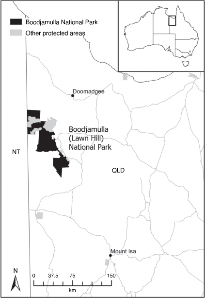
Boodjamulla National Park, comprising 10 adjoining protected areas, covers 388 363 ha in north-western Queensland (Fig. 1). The park is managed by the Queensland Parks and Wildlife Service (QPWS) and protects a landscape of spinifex (Triodia spp.)-dominated rangelands, as well as restricted fire-sensitive vegetation communities such as springs, riparian forests, and lancewood (Acacia shirleyi Maiden) outcrops. The spinifex rangelands are a highly fire-prone semi-arid landscape (average annual rainfall between 400 and 600 mm), with high spring and summer temperatures (mean maximum November and February temperatures are 39.1°C and 36.5°C respectively), and a long austral winter dry season (Bureau of Meteorology 2022).
|
Prescribed burn planning
The QPWS manages the implementation of prescribed burn programs on protected estates as part of its legislative obligations and responsibilities. The process follows the guidelines described in the QPWS Bioregional Planned Burn Guidelines, and involves three main steps, namely (i) planning, (ii) implementation and (iii) assessment, monitoring and evaluation (Melzer and Hines 2022). Although this study reports on changing fire metrics for the period from 2000 to 2020, between 2000 and 2011 fire management at Boodjamulla was more reactive, and did not involve a consistent, sustained approach to regular prescribed burning. The following methodology for planning and implementation, therefore, refers to the period between 2012 and 2020 when there was more focus and emphasis on rigorous EDS burning approaches.
A critical component of the annual prescribed-burn program is a review of fire-history mapping to ensure a strategic approach to ignition. The main source of fire-history data in northern Australia is the North Australia Fire Information website (NAFI – www.firenorth.org.au) which provides annual fire scar vector mapping at 250 m resolution, derived from MODIS imagery (NASA MODIS, http://modis.gsfc.nasa.gov/). These data were downloaded and clipped to the park boundary (see Fig. 1) and attributed by year, month, and season. Boodjamulla is situated between the tropical savanna region of northern Australia and the semi-arid rangelands further south, and experiences highly variable rainfall; as such, the QPWS define the EDS as February to July and the LDS as August to January.
The metric, time since last burnt, was used as a proxy for spinifex age class (where 1 year since last burnt is 1 year old spinifex) and therefore fuel load (where 0–4 years old is classified as low fuel loads, and >4 years old is high fuel loads), and indicates where EDS prescribed burns might have been required. Extensive stands of contiguous older-aged spinifex were prioritised for ignition, the aim being to fragment older spinifex into smaller patches to insure against total combustion in the LDS. Areas that were sufficiently patchy (at least three age classes of spinifex within a 1000 ha2) or were recently burnt were not targeted for treatment in the year. The fire history maps were overlain with vegetation maps (Queensland Herbarium 2021) showing the location of fire-sensitive vegetation communities. Together these data were used to determine where EDS burning was recommended, and the number and location of transects along which to undertake annual burn program ignition.
Prescribed burn implementation
Due to the large spatial scale and inaccessibility of Boodjamulla, most of the prescribed-burn program was delivered by aerial incendiary. Operations were conducted from Robinson 44 helicopters by using an aerial incendiary machine, which dispenses small capsules (potassium permanganate and glycol), that ignite approximately 20 s after release. The ignition transects were typically 1 km apart, and capsules were dropped at approximately 200 m spacings, although the ignition pattern was adjusted during operations according to the observed fire behaviour, distribution of fuel types and fuel loads, and any changes in prevailing weather patterns.
The prescribed burning was conducted during mild conditions with high humidity and soil moisture in the late wet/early dry seasons (typically March–May). This ensured that fires were of low intensity and would extinguish overnight or along natural features such as rivers and escarpments. In most years, the burns were completed within a 1–2 week period. In wetter years, the program was staggered over several months, with areas revisited when the fuels were more cured. The aim was to ensure a sufficient number and distribution of burnt patches to help minimise the risk of extensive LDS wildfires.
Spatial metrics analysis
Assessment, monitoring and evaluation are important components of fire management (Melzer and Hines 2022). As indicated above, the core metrics used for planning prescribed burns are proxy fuel loads (time since last burn) and patch sizes of long-unburnt vegetation. The availability of long-term fire history data from the NAFI website allows managers to look at the success of long-term fire programs retrospectively, and examine new metrics known to represent improved fire patterns for biodiversity outcomes (e.g. pyrodiversity Jones and Tingley 2022). In recognising the shift in fire management at Boodjamulla between 2000–2011 and 2012–2020, I examined a range of fire metrics to contrast the fire-regime change between 2000 and 2020.
Annual and seasonal area burnt
This metric identifies the area of vegetation burnt annually and by season, and is the foundation for all annual prescribed-burn planning by QPWS. I examined fire-scar data between 2000 and 2020 by season and year, applying procedures recommended by Fisher and Edwards (2015). The fire-management objective for this metric is a decrease in the annual fire extent and the proportion of area burnt in the LDS (Russell-Smith and Edwards 2006).
Burnt patch characteristics
This metric identifies the number of patches burnt and the mean annual patch area at Boodjamulla from 2000 to 2020. These were calculated separately for EDS and LDS periods. Although this metric is not used in prescribed-burn planning, it is valuable for assessing the patchiness of a fire regime. The fire-management objective for this metric is to decrease the area of burnt patches and increase the frequency of smaller EDS patches, as a patch area below 100 ha (1 km2) is considered ideal for biodiversity conservation in savanna and spinifex rangelands (Felderhof 2007; Radford 2012).
Heterogeneity index
This metric identifies the heterogeneity of the fire landscape by using a GIS model (Price et al. 2005) based on the MODIS-derived fire history with 250 m pixels. The index is calculated by using a 5 × 5 (25 ha) moving ‘window’, provides a count of the number of burnt and unburnt patches surrounding the central cell, and then re-calibrates the entire dataset to a percentage from the least to the most heterogeneous state. The value of each cell is then averaged for 5-year periods to obtain the final heterogeneity index score (Price et al. 2005). I examined this heterogeneity index for three 7-year time ranges between 2000 and 2020 (2000–2006; 2007–2013; 2014–2020) as a proxy for mosaic patchiness, although it is not currently used in prescribed-burn planning. The fire management objective for this metric is to increase landscape fire heterogeneity, as it is linked to the persistence and population increases in taxonomic groups such as ground dwelling mammals (Swan et al. 2020).
Average distance between long-unburnt and recently burnt spinifex
This metric identifies the average distance from recently burnt spinifex (<1 year) to the nearest long-unburnt (≥5 years old) patch that is larger than 62 ha. The GIS model for this analysis selected any unburnt patches larger than nine cells (a single cell size is 6.25 ha). This was to ensure that unburnt patches in the analysis were sufficiently large to be considered beneficial for biodiversity, and to account for potential mapping error with the imagery. The distance from recently burnt vegetation to longer-unburnt vegetation is used as an index for assessing whether the availability of unburnt habitat has changed as measured by the increase or decrease in the mean distance between unburnt patches (Edwards et al. 2021). I examined this metric for the period 2000–2020, although it is not currently used in prescribed-burn planning. The fire-management objective for this metric is to reduce the distances between recently burnt patches and long-unburnt refugia, so that fauna can persist in or near their pre-fire ranging area (Radford 2012).
Extent of long-unburnt spinifex (≥5 years old)
This metric identifies the distribution of spinifex ages across the park. I examined this metric for the period 2000–2020, although it too is not currently used in prescribed-burn planning. The aim for improved fire management for this metric is to increase the area of long-unburnt spinifex patches, as the retention of long-unburnt vegetation in flammable landscapes is considered critical for biodiversity, particularly small-mammal and bird taxa, ensuring that animals that rely on unburnt vegetation can persist in the landscape (Woinarski and Recher 1997; Andersen et al. 2005; Woinarski and Legge 2013; Shaw et al. 2021).
Results
Over the 21-year period (2000–2020), at Boodjamulla, EDS prescribed burning was conducted annually except for 2001, 2002, 2006, 2007 and 2008. The timing of burn operations varied across the EDS, the earliest being February and the latest being July.
Annual and seasonal area burnt
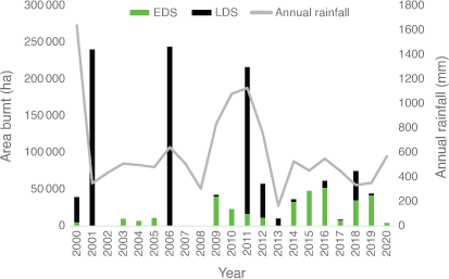
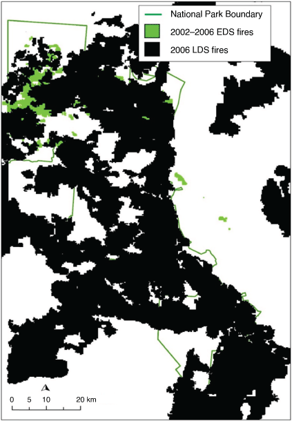
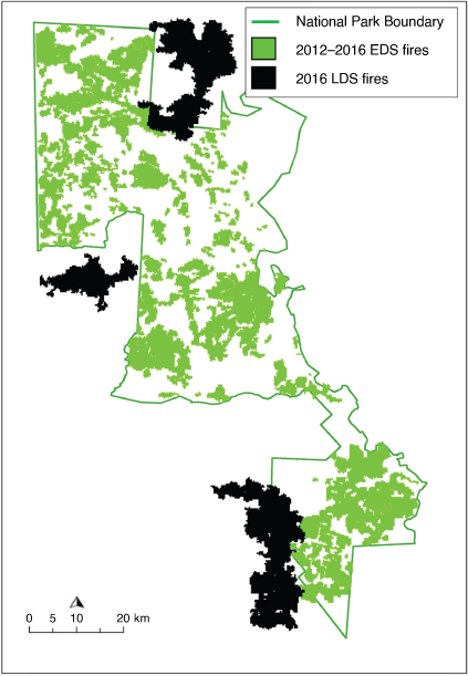
The average total area of Boodjamulla burnt annually between 2000 and 2020 was 56 234 ha, ranging from 244 229 ha in 2006 to no burns in 2002 and 2008. The 5-year wildfire cycle is evident in the large areas burnt in LDS wildfires in 2001, 2006 and 2011, with very low total area burnt in the intervening years (Fig. 2). Prior to the 2006 LDS wildfire, only 27 571 ha had been burnt in EDS prescribed burns between 2002 and 2006, with 80 594 ha burnt in EDS prescribed burns between 2007 and 2011 prior to the 2011 wildfire (Fig. 2). Fig. 3 shows the lack of EDS burns leading up to the 2006 LDS wildfire. With the effort to break the wildfire cycle by increasing EDS prescribed burns after 2011, EDS burns were an increasing proportion of the annual burnt area (Fig. 2). Between 2012 and 2016, 146 531 ha were burnt in EDS prescribed burns, compared with 67 644 ha in LDS wildfires. When three LDS wildfires approached the park boundaries in 2016, they largely extinguished on the young fuel created by previous EDS prescribed burns, effectively breaking the 5-year wildfire cycle (Fig. 4). Average annual area burnt declined between 2012 and 2020 (69 557 ha pre-2012, 38 469 ha post 2012), and LDS wildfires were a minor component after 2011 (3% of average annual area burnt).
|
|
|
Burnt patch characteristics
The low number of patches and high mean patch size associated with large LDS wildfires are evident in the data for 2001 and 2006. The regime shift after 2011 is evident in the increasing number of EDS patches, with the mean annual number of EDS patches increasing from seven between 2000 and 2011 to 45 between 2012 and 2020. As patch number increased, both mean LDS and mean annual patch size decreased between the 2000–2011 and 2012–2020 periods (184.8–17 km2; 157.3–9.9 km2 respectively, Table 1). The mean EDS patch size also nearly halved from 11.3 km2 in 2000–2011 to 6.4 km2 in 2012 to 2020.

|
Heterogeneity index
There was a shift from a more to a less homogenous fire environment over the 2000–2006, 2007–2013 and 2014–2020 periods (Fig. 5). The uniformity of the landscape in the first two periods, which includes the effect of the 2001, 2006 and 2011 fires, is evident in the dominance of lower scores. In 2014–2020, the mosaic effect of the prescribed-burn program is evident, the higher scores (15–18) most likely emerging as a result of the patchiness of the EDS burns over those years.

|
Average distance between long-unburnt and recently burnt spinifex
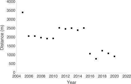
Because spatial data were unavailable prior to 2000, Fig. 6 begins at 2005 (the previous 5 years of fire history are used to calculate the availability of spinifex of at least 5 years in age). The average distance between recently burnt (<1 year) to long-unburnt (≥5 years) spinifex declined from 3.4 km in 2005 to 940 m in 2020 (Fig. 6), with a noticeable decline in 2016.
|
Extent of long-unburnt spinifex (≥5 years old)
Similarly, Fig. 7 begins at 2009 to include the previous 10 year fire history. In 2009, there were six spinifex age classes represented, the most frequent being 4 years (Fig. 7). In 2011, the most frequent was 1 year, and by 2020 the spinifex was more evenly distributed across all age classes. The proportion of long-unburnt spinifex (≥5 years) increased markedly from 26% in 2009 and 33% in 2011 to 67% in 2020. Fig. 8 shows an example of the loss of long-unburnt spinifex in a large LDS wildfire (2006) compared with its retention in a mosaic of mixed age classes (2018).

|

|
Discussion
Over time, with a clear focus on planning and implementation of EDS prescribed burning, fire regimes in large conservation reserves can change from being largely extensive wildfire-mediated systems with potential long-term negative consequences for biodiversity, to landscapes with a greater heterogeneity and long-unburnt vegetation. This has been demonstrated elsewhere in northern Australia (Evans and Russell-Smith 2020), including the benefits for biodiversity (Shaw et al. 2021). From its gazettal in 1984 until 2011, fire management at Boodjamulla National Park was largely reactionary. It included a negligible amount of annual EDS prescribed burning, punctuated by a large LDS wildfire response every 5 years. Fire management over those years failed to establish a landscape-scale EDS prescribed-burn program that created sufficiently extensive areas of young age-class spinifex to contain LDS wildfires. From 2012, fire management at Boodjamulla moved to a proactive program of extensive annual EDS burning. This was largely a result of consistent practitioners at an operational level using spatial data and aerial resources to ensure the annual burn program met the objectives of the Bioregional Planned Burn Guidelines.
By progressively burning patchy, low-intensity fires on a park-wide scale every year, the landscape was unable to carry the previous extensive LDS wildfires. I have presented some key metrics that have demonstrated how the change from LDS wildfires to EDS burning created tangible changes in the vegetation and landscape patterns. There are various approaches to quantifying fire-induced patchiness (Russell-Smith et al. 2015; Edwards et al. 2021). Although there are limitations associated with applying the heterogeneity index without statistical analysis, this metric provides an effective spatial representation of landscape-scale patchiness. The progressive increase in fire-induced heterogeneity was evident over the years that the landscape mosaic developed, and the wildfire cycle was broken. This pattern is supported by the burnt-patch characteristics of an increase in number of EDS patches, a reduction in mean patch size with the change in fire regime, and a mean patch size being close to the recommended 100 ha by 2020. Landscape patchiness has also promoted shorter distances between recently burnt and long-unburnt patches, and a more even spread of spinifex age classes. These metrics complement other park monitoring data that have demonstrated improvement in the ecological parameters of the spinifex rangelands and fire-sensitive vegetation communities at Boodjamulla (Melzer et al. 2019), and that the population of Carpentarian grasswrens on the park is persisting (BirdLife Australia, unpubl. data).
The most significant outcome from breaking this 5 year wildfire cycle at Boodjamulla has been the expansion of long-unburnt spinifex in the landscape that has increased within the diverse mosaic of age classes. This has created a landscape more resilient to occasional LDS wildfires, but no longer dominated by them. Although a large extensive wildfire in spinifex dominated systems is considered a natural component of arid Australia (Wright et al. 2021), in multi-use semi-arid savannas where rainfall can promote shorter fire-return periods, there is clear recognition that prescribed burning to promote more mosaic landscapes is critical for threatened species (Radford et al. 2020).
The QPWS have reached a point where a more nuanced approach to EDS burning can be adopted. The heterogeneity of the landscape is such that only small areas of the park require burning on an annual basis, with specific areas selected for ignition on the basis of the fine-scale distribution of spinifex ages. Apart from a conservation benefit, this has a significant effect on the annual budget for prescribed burning, as well as wildfire management. For example, fire management at Boodjamulla no longer includes wildfire response, and now costs approximately AU$75000 over 5 years, and consists entirely of EDS burn-program funding. This is a significant reduction from the 5 years of combined EDS burning and wildfire response expenses between 2002 and 2006, which cost over AU$230 000 (L. Ezzy, unpubl. data).
Strong associations between high-rainfall events and large LDS wildfires are well documented across Australia (Wright et al. 2021). For Boodjamulla, it is difficult to separate the contribution of high rainfall from that of limited EDS prescribed burning in driving large LDS wildfire events in its recent history. Rainfall is highly variable across Boodjamulla, owing to its 130 km-long latitudinal gradient in the semi-arid tropics. Accurate long-term rainfall data are available only at one weather station on the park (Lawn Hill Gorge, mean rainfall 595 mm). The significant wet seasons prior to the large 2001 and 2011 fires may have contributed to fire extent, particularly considering the lack of EDS prescribed burns. However, the large LDS fire in 2006 was preceded by average to below-average seasons and occurred prior to the implementation of the more thorough program of EDS burns. This suggests that rainfall alone is not necessarily the catalyst for large wildfire events; even-aged spinifex vegetation can carry fire if the fuel load is sufficient and contiguous. Therefore, an effective EDS burn program can reduce the likelihood of large LDS wildfires, irrespective of large rainfall events, owing to the disruption to the continuous fuel load (i.e. greater heterogeneity).
Some limitations exist with the MODIS imagery and analysis used for this program. MODIS is considered moderate-resolution satellite imagery. However, the overall accuracy derived from MODIS-based studies is not markedly lower than that obtained using higher-resolution satellite imagery, such as Landsat (Edwards et al. 2018). Given that MODIS under-represents the incidence of small (<250 ha) patch sizes (Roteta et al. 2019), there is likely to be more patchiness, and therefore unburnt area, in the EDS burn program than this review suggests. The QPWS consider the applied imagery scale to be generally adequate for park management purposes; however, the use of finer-scale imagery such as Landsat and Sentinel should enhance future work at Boodjamulla by providing more detail on fine-scale patterns. The management of extensive landscapes for conservation are always faced with trade-offs among technology, resources, and application (Campagnolo et al. 2021; Wysong et al. 2022). However, it is important to adopt the most appropriate tools for fire planning and implementation and monitor long-term outcomes and change.
Conclusions
Although the Boodjamulla burn program has succeeded in creating a landscape of diverse age classes and more long-unburnt refugia than did the previous regime, it is not a simple matter of translating these metrics into tangible improvements in biodiversity conservation. This challenge is not unique to Boodjamulla. Within the Australian context, studies linking faunal responses to fire regimes are usually correlative (Griffiths et al. 2015; Corey et al. 2020; Jones and Tingley 2022). Considering the complexity of biodiversity monitoring and the fact that biodiversity responses may take years to be realised, it is unsurprising that this remains a challenging area for fire managers.
Indeed, the broad adoption of EDS burn programs across northern Australia has prompted debate on the risk of ‘bioperversity’ occurring, namely, unintended outcomes for biodiversity that may result from the mosaic burning paradigm (Corey et al. 2020). A common assertion is that by reducing the frequency, severity and extent of fires, particularly in greenhouse-gas (GHG) abatement programs, there are inherent co-benefits for biodiversity. However, in most cases, the ecological significance of different burning patterns remains poorly understood and seldom scrutinised (Parr and Andersen 2006; Woinarski and Legge 2013). In contrast to the Boodjamulla burn program in the spinifex rangelands, the application of EDS prescribed burning in northern Australian savannas has not always resulted in an increase in longer-unburnt areas (Corey et al. 2020).
Boodjamulla straddles the transition zone between the mesic tussock grass-dominated savannas of the north and the more arid interior hummock grasslands. Whereas there has been considerable focus on taxa-specific responses to fire in the northern savannas (Andersen et al. 2012; Woinarski and Legge 2013; Radford et al. 2020; Andersen 2021), there has been limited research in the semi-arid spinifex rangelands (Williams et al. 2006; Felderhof 2007). Williams et al. (2006) recommended a minimum recurring post-fire interval of approximately 5 years to ensure reproductive success of most obligate-seeder shrub taxa. Felderhof (2007) developed a fauna fire-response model that allowed a ‘best guess’ recommendation of 100 ha as an ideal patch area in the Mount Isa Inlier. Although there are clear objectives in prescribed-burn guidelines for land managers, these revolve around fire indices and vegetation and are still considered ‘educated guesses’ with regard to appropriate scale, frequency and heterogeneity for biodiversity (Felderhof 2007). Specific monitoring of biodiversity responses to fire would further enhance the Boodjamulla burn program and provide a better understanding of the more subtle ecological requirements of this landscape.
Although the mosaic burning program has demonstrated the possibility of reducing extensive LDS wildfires in spinifex rangelands, it is not the intention of the QPWS to exclude such fires from Boodjamulla altogether, and LDS wildfires are still considered a natural and important dynamic of the landscape. For example, regrowth in spinifex usually responds more rapidly after a LDS wildfire than after an EDS prescribed burn because of subsequent wet-season rain (Felderhof 2007). It is important to recognise such trade-offs when managing a fire-adapted landscape that should ultimately be sufficiently resilient to accommodate fire throughout the year. The question of what defines the most suitable landscape condition for biodiversity conservation remains unanswered. In the meantime, as understanding of the ecology improves, QPWS will continue to employ a flexible adaptive management approach that sets objectives on the basis of current evidence, and acknowledges uncertainty.
Data availability
The data that support this study are available on North Australia & Rangelands Fire Information website at https://firenorth.org.au/nafi3/.
Conflicts of interest
The author declares no conflicts of interest.
Declaration of funding
This research did not receive any specific funding.
Acknowledgements
Boodjamulla National Park is within the Traditional lands of Waanyi; I acknowledge the ongoing custodianship and connection of Waanyi to their country. Grateful thanks to Dr Rhonda Melzer, Dr Alex Kutt, Dr Steve Murphy, Aidan Joseph, Dr Andrew Edwards, Mike Harte and QPWS&P Central Region staff for their various contributions to this work. This paper is dedicated to the memory of rangeland ecologist Dr Tony Grice.
References
Alba, C, Skálová, H, McGregor, KF, D’Antonio, C, and Pyšek, P (2015). Native and exotic plant species respond differently to wildfire and prescribed fire as revealed by meta-analysis. Journal of Vegetation Science 26, 102–113.| Native and exotic plant species respond differently to wildfire and prescribed fire as revealed by meta-analysis.Crossref | GoogleScholarGoogle Scholar |
Andersen, AN (2021). Faunal responses to fire in Australian tropical savannas: insights from field experiments and their lessons for conservation management. Diversity and Distributions 27, 828–843.
| Faunal responses to fire in Australian tropical savannas: insights from field experiments and their lessons for conservation management.Crossref | GoogleScholarGoogle Scholar |
Andersen, AN, Cook, GD, Corbett, LK, Douglas, MM, Eager, RW, Russell-Smith, J, Setterfield, SA, Williams, RJ, and Woinarski, JCZ (2005). Fire frequency and biodiversity conservation in Australian tropical savannas: implications from the Kapalga fire experiment. Austral Ecology 30, 155–167.
| Fire frequency and biodiversity conservation in Australian tropical savannas: implications from the Kapalga fire experiment.Crossref | GoogleScholarGoogle Scholar |
Andersen, AN, Woinarski, JCZ, and Parr, CL (2012). Savanna burning for biodiversity: fire management for faunal conservation in Australian tropical savannas. Austral Ecology 37, 658–667.
| Savanna burning for biodiversity: fire management for faunal conservation in Australian tropical savannas.Crossref | GoogleScholarGoogle Scholar |
Bowman, DMJS, Brown, GK, Braby, MF, Brown, JR, Cook, LG, Crisp, MD, Ford, F, Haberle, S, Hughes, J, Isagi, Y, Joseph, L, McBride, J, Nelson, G, and Ladiges, PY (2010). Biogeography of the Australian monsoon tropics. Journal of Biogeography 37, 201–216.
| Biogeography of the Australian monsoon tropics.Crossref | GoogleScholarGoogle Scholar |
Bureau of Meteorology (2022) Climate Data Online. Available at http://www.bom.gov.au/climate/data/ [accessed 15 February 2022]
Campagnolo, ML, Libonati, R, Rodrigues, JA, and Pereira, JMC (2021). A comprehensive characterization of MODIS daily burned area mapping accuracy across fire sizes in tropical savannas. Remote Sensing of Environment 252, 112115.
| A comprehensive characterization of MODIS daily burned area mapping accuracy across fire sizes in tropical savannas.Crossref | GoogleScholarGoogle Scholar |
Corey, B, Andersen, AN, Legge, S, Woinarski, JCZ, Radford, IJ, and Perry, JJ (2020). Better biodiversity accounting is needed to prevent bioperversity and maximize co-benefits from savanna burning. Conservation Letters 13, e12685.
| Better biodiversity accounting is needed to prevent bioperversity and maximize co-benefits from savanna burning.Crossref | GoogleScholarGoogle Scholar |
Crowley, G, Garnett, S, and Shephard, S (2009). Impact of storm-burning on Melaleuca viridiflora invasion of grasslands and grassy woodlands on Cape York Peninsula, Australia. Austral Ecology 34, 196–209.
| Impact of storm-burning on Melaleuca viridiflora invasion of grasslands and grassy woodlands on Cape York Peninsula, Australia.Crossref | GoogleScholarGoogle Scholar |
Edwards, AC, Russell-Smith, J, and Maier, SW (2018). A comparison and validation of satellite-derived fire severity mapping techniques in fire prone north Australian savannas: extreme fires and tree stem mortality. Remote Sensing of Environment 206, 287–299.
| A comparison and validation of satellite-derived fire severity mapping techniques in fire prone north Australian savannas: extreme fires and tree stem mortality.Crossref | GoogleScholarGoogle Scholar |
Edwards, A, Archer, R, De Bruyn, P, Evans, J, Lewis, B, Vigilante, T, Whyte, S, and Russell-Smith, J (2021). Transforming fire management in northern Australia through successful implementation of savanna burning emissions reductions projects. Journal of Environmental Management 290, 112568.
| Transforming fire management in northern Australia through successful implementation of savanna burning emissions reductions projects.Crossref | GoogleScholarGoogle Scholar |
Evans, J, and Russell-Smith, J (2020). Delivering effective savanna fire management for defined biodiversity conservation outcomes: an Arnhem Land case study. International Journal of Wildland Fire 29, 386–400.
| Delivering effective savanna fire management for defined biodiversity conservation outcomes: an Arnhem Land case study.Crossref | GoogleScholarGoogle Scholar |
Felderhof L (2007) The fire patchiness paradigm: a case study in northwest Queensland. PhD Thesis, James Cook University, Townsville, Qld, Australia.
Fisher R, Edwards AC (2015) Fire extent mapping: procedures, validation and website application. In ‘Carbon accounting and savanna fire management’. (Eds B Murphy, A Edwards, M Meyer, J Russell-Smith) pp. 57–72. (CSIRO Publishing: Melbourne, Vic., Australia)
Franklin, DC (1999). Evidence of disarray amongst granivorous bird assemblages in the savannas of northern Australia, a region of sparse human settlement. Biological Conservation 90, 53–68.
| Evidence of disarray amongst granivorous bird assemblages in the savannas of northern Australia, a region of sparse human settlement.Crossref | GoogleScholarGoogle Scholar |
Gill, AM, Allan, G, and Yates, C (2003). Fire-created patchiness in Australian savannas. International Journal of Wildland Fire 12, 323–331.
| Fire-created patchiness in Australian savannas.Crossref | GoogleScholarGoogle Scholar |
Griffiths, AD, Garnett, ST, and Brook, BW (2015). Fire frequency matters more than fire size: testing the pyrodiversity-biodiversity paradigm for at-risk small mammals in an Australian tropical savanna. Biological Conservation 186, 337–346.
| Fire frequency matters more than fire size: testing the pyrodiversity-biodiversity paradigm for at-risk small mammals in an Australian tropical savanna.Crossref | GoogleScholarGoogle Scholar |
Harrington, GN, and Murphy, SA (2015). The distribution and conservation status of Carpentarian grasswrens (Amytornis dorotheae), with reference to prevailing fire patterns. Pacific Conservation Biology 21, 291–297.
| The distribution and conservation status of Carpentarian grasswrens (Amytornis dorotheae), with reference to prevailing fire patterns.Crossref | GoogleScholarGoogle Scholar |
Harrington G, Freeman A, Murphy S, Venables B, Edwards C (2011) Carpentarian Grasswren survey: Boodjamulla National Park, 15–30 June 2011. Internal Report, BirdLife Australia, North Queensland.
Jones, GM, and Tingley, MW (2022). Pyrodiversity and biodiversity: a history, synthesis and outlook. Diversity and Distributions 28, 386–403.
| Pyrodiversity and biodiversity: a history, synthesis and outlook.Crossref | GoogleScholarGoogle Scholar |
Legge, S, Murphy, S, Kingswood, R, Maher, B, and Swan, D (2011). EcoFire: restoring the biodiversity values of the Kimberley region by managing fire. Ecological Management & Restoration 12, 84–92.
| EcoFire: restoring the biodiversity values of the Kimberley region by managing fire.Crossref | GoogleScholarGoogle Scholar |
Melzer R, Hines HB (2022) Queensland Parks and Wildlife Service Bioregional Planned Burn Guideline: Introductory Volume. Unpublished report, Department of Environment and Science, Queensland Government.
Melzer, R, Ezzy, L, and Hines, HB (2019). Health Checks: a simple tool for assessing the condition of values and effectiveness of reserve management. Parks 25, 67–78.
| Health Checks: a simple tool for assessing the condition of values and effectiveness of reserve management.Crossref | GoogleScholarGoogle Scholar |
Parr, CL, and Andersen, AN (2006). Patch mosaic burning for biodiversity conservation: a critique of the pyrodiversity paradigm. Conservation Biology 20, 1610–19.
| Patch mosaic burning for biodiversity conservation: a critique of the pyrodiversity paradigm.Crossref | GoogleScholarGoogle Scholar |
Price, O, Edwards, A, Connors, G, Woinarski, J, Ryan, G, Turner, A, and Russell-Smith, J (2005). Fire heterogeneity in Kakadu National Park, 1980–2000. Wildlife Research 32, 425–433.
| Fire heterogeneity in Kakadu National Park, 1980–2000.Crossref | GoogleScholarGoogle Scholar |
Queensland Government (2013) Planned Burn Guidelines: Northwest Highlands Bioregion of Queensland. Available at https://parks.des.qld.gov.au/__data/assets/pdf_file/0020/157025/pbg-nothwest-highlands.pdf
Queensland Herbarium (2021) Regional Ecosystem Description Database (REDD). Version 12.1 (December 2021). Queensland Department of Environment and Science, Brisbane, Qld, Australia.
Radford, IJ (2012). Threatened mammals become more predatory after small-scale prescribed fires in a high-rainfall rocky savanna. Austral Ecology 37, 926–935.
| Threatened mammals become more predatory after small-scale prescribed fires in a high-rainfall rocky savanna.Crossref | GoogleScholarGoogle Scholar |
Radford, IJ, Woolley, L-A, Corey, B, Vigilante, T, Wunambal Gaambera Aboriginal Corporation, Hatherley, E, Fairman, R, Carnes, K, and Start, AN (2020). Prescribed burning benefits threatened mammals in northern Australia. Biodiversity and Conservation 29, 2985–3007.
| Prescribed burning benefits threatened mammals in northern Australia.Crossref | GoogleScholarGoogle Scholar |
Rossiter, NA, Setterfield, SA, Douglas, MM, and Hutley, LB (2003). Testing the grass-fire cycle: alien grass invasion in the tropical savannas of northern Australia. Diversity and Distributions 9, 169–176.
| Testing the grass-fire cycle: alien grass invasion in the tropical savannas of northern Australia.Crossref | GoogleScholarGoogle Scholar |
Roteta, E, Bastarrika, A, Padilla, M, Storm, T, and Chuvieco, E (2019). Development of a Sentinel-2 burned area algorithm: generation of a small fire database for sub-Saharan Africa. Remote Sensing of Environment 222, 1–17.
| Development of a Sentinel-2 burned area algorithm: generation of a small fire database for sub-Saharan Africa.Crossref | GoogleScholarGoogle Scholar |
Russell-Smith, J, and Edwards, AC (2006). Seasonality and fire severity in savanna landscapes of monsoonal northern Australia. International Journal of Wildland Fire 15, 541–550.
| Seasonality and fire severity in savanna landscapes of monsoonal northern Australia.Crossref | GoogleScholarGoogle Scholar |
Russell-Smith, J, Murphy, BP, Meyer, CP, Cook, GD, Maier, S, Edwards, AC, Schatz, J, and Brocklehurst, P (2009). Improving estimates of savanna burning emissions for greenhouse accounting in northern Australia: limitations, challenges, applications. International Journal of Wildland Fire 18, 1–18.
| Improving estimates of savanna burning emissions for greenhouse accounting in northern Australia: limitations, challenges, applications.Crossref | GoogleScholarGoogle Scholar |
Russell-Smith, J, Yates, CP, Edwards, AC, Whitehead, PJ, Murphy, BP, and Lawes, MJ (2015). Deriving multiple benefits from carbon market-based savanna fire management: an Australian example. PLoS One 10, e0143426.
| Deriving multiple benefits from carbon market-based savanna fire management: an Australian example.Crossref | GoogleScholarGoogle Scholar |
Russell-Smith, J, Edwards, AC, Sangha, KK, Yates, CP, and Gardener, MR (2020). Challenges for prescribed fire management in Australia’s fire-prone rangelands: the example of the Northern Territory. International Journal of Wildland Fire 29, 339–353.
| Challenges for prescribed fire management in Australia’s fire-prone rangelands: the example of the Northern Territory.Crossref | GoogleScholarGoogle Scholar |
Shaw, RE, James, AI, Tuft, K, Legge, S, Cary, GJ, Peakall, R, and Banks, SC (2021). Unburnt habitat patches are critical for survival and in situ population recovery in a small mammal after fire. Journal of Applied Ecology 58, 1325–1335.
| Unburnt habitat patches are critical for survival and in situ population recovery in a small mammal after fire.Crossref | GoogleScholarGoogle Scholar |
Swan, M, Christie, F, Steel, E, Sitters, H, York, A, and Di Stefano, J (2020). Ground-dwelling mammal diversity responds positively to productivity and habitat heterogeneity in a fire-prone region. Ecosphere 11, e03248.
| Ground-dwelling mammal diversity responds positively to productivity and habitat heterogeneity in a fire-prone region.Crossref | GoogleScholarGoogle Scholar |
van Wilgen, BW, Forsyth, GG, de Klerk, H, Das, S, Khuluse, S, and Schmitz, P (2010). Fire management in Mediterranean-climate shrublands: a case study from the Cape fynbos, South Africa. Journal of Applied Ecology 47, 631–638.
| Fire management in Mediterranean-climate shrublands: a case study from the Cape fynbos, South Africa.Crossref | GoogleScholarGoogle Scholar |
Ward, M, Tulloch, AIT, Radford, JQ, Williams, BA, Reside, AE, Macdonald, SL, Mayfield, HJ, Maron, M, Possingham, HP, Vine, SJ, O’Connor, JL, Massingham, EJ, Greenville, AC, Woinarski, JCZ, Garnett, ST, Lintermans, M, Scheele, BC, Carwardine, J, Nimmo, DG, Lindenmayer, DB, Kooyman, RM, Simmonds, JS, Sonter, LJ, and Watson, JEM (2020). Impact of 2019–2020 mega-fires on Australian fauna habitat. Nature Ecology & Evolution 4, 1321–1326.
| Impact of 2019–2020 mega-fires on Australian fauna habitat.Crossref | GoogleScholarGoogle Scholar |
Williams, P, Collins, E, Mason, D, Prince, J, and Anchen, G (2006). Variation in the age at first flowering for seedlings of 15 fire-killed shrubs and trees on sandstone outcrops and sand plains in central and north-western Queensland. Ecological Management and Restoration 7, 61–63.
| Variation in the age at first flowering for seedlings of 15 fire-killed shrubs and trees on sandstone outcrops and sand plains in central and north-western Queensland.Crossref | GoogleScholarGoogle Scholar |
Woinarski, JCZ, and Legge, S (2013). The impacts of fire on birds in Australia’s tropical savannas. Emu - Austral Ornithology 113, 319–352.
| The impacts of fire on birds in Australia’s tropical savannas.Crossref | GoogleScholarGoogle Scholar |
Woinarski, JCZ, and Recher, HF (1997). Impact and response: a review of the effects of fire on the Australian avifauna. Pacific Conservation Biology 3, 183–205.
| Impact and response: a review of the effects of fire on the Australian avifauna.Crossref | GoogleScholarGoogle Scholar |
Wright, BR, Laffineur, B, Royé, D, Armstrong, G, and Fensham, RJ (2021). Rainfall-linked megafires as innate fire regime elements in arid Australian spinifex (Triodia spp.) grasslands. Frontiers in Ecology and Evolution 9, 666241.
| Rainfall-linked megafires as innate fire regime elements in arid Australian spinifex (Triodia spp.) grasslands.Crossref | GoogleScholarGoogle Scholar |
Wysong, M, Legge, S, Clark, A, Maier, S, Bardi Jawi Rangers, Nyul Nyul Rangers, Yawuru Country Managers, Cowell, S, and Mackay, G (2022). The sum of small parts: changing landscape fire regimes across multiple small landholdings in north-western Australia with collaborative fire management. International Journal of Wildland Fire 31, 97–111.