

A case study of liquefaction risk analysis based on the thickness and depth of the liquefaction layer using CPT and electric resistivity data in the Hinode area, Itako City, Ibaraki Prefecture, Japan
Motoharu Jinguuji 1 3 Selcuk Toprak 21 National Institute of Advanced Industrial Science and Technology, 1-1-1-C7 Higashi, Ibaraki 305-8567, Japan.
2 Department of Civil Engineering, Pamukkale University, Kinikli Campus Denizli, 20070, Turkey.
3 Corresponding author. Email: m.jinguuji@aist.go.jp
Exploration Geophysics 48(1) 28-36 https://doi.org/10.1071/EG16137
Submitted: 10 November 2016 Accepted: 14 November 2016 Published: 22 December 2016
Abstract
The Hinode area of Itako City in Ibaraki Prefecture, Japan, suffered some of the most severe liquefaction damage of any areas in the Great Eastern Japan Earthquake in 2011. This liquefaction damage has been investigated by Itako City, as well as by universities and research institutes in Japan. The National Institute of Advanced Industrial Science and Technology (AIST) has carried out numerous investigations along the Tone River, and in particular, intensive surveys were done in the Hinode area. We have conducted a risk analysis based on the thickness and depth of the liquefaction layer measured using cone penetration testing (CPT) data and electric resistivity data obtained in the Hinode area. The distribution of the risk estimated from CPT at 143 points, and that obtained from analysis of the resistivity survey data, agreed with the distribution of actual damage. We also carried out conventional risk analyses method using the liquefaction resistance factor (FL) and liquefaction potential index (PL) methods with CPT data. The results show high PL values over the entire area, but their distribution did not agree well with actual damage in some parts of the study area. Because the analysis of the thickness and depth of the liquefaction layer, using geophysical prospecting methods, can cover a widespread area, this method will be very useful in investigating liquefaction risk, especially for gas and water pipelines.
Key words: 2011 Great Eastern Japan Earthquake, CPT, electric resistivity survey, liquefaction.
Introduction
The Great Eastern Japan Earthquake in 2011 caused tremendous liquefaction damage in the Tohoku and Kanto areas, particularly along the lower reaches of the Tone River and around Tokyo Bay. The damage caused by liquefaction was at a remarkably huge scale, particularly in residential areas. Much of the infrastructure, such as roads and water and gas pipelines, that was not designed or constructed to stand up against liquefaction, was terribly damaged. Investigations after the earthquake revealed that the liquefaction damage was concentrated in artificial land along rivers and channels or in former wetlands (Komatsubara et al., 2014). Because liquefaction occurred over such a widespread area, the need for a new technique to enable rapid investigation over wide areas was recognised, especially for evaluating liquefaction risk to water and gas pipelines. A geophysical exploration method that includes the electric resistivity method can investigate the geological structure of the liquefiable layer from the surface.
The National Institute of Advanced Industrial Science and Technology (AIST) carried out research on liquefaction and very large-scale geological and geophysical investigations along the lower reaches of the Tone River. In this paper, we present a case study in which we map the liquefaction risk for the Hinode area of Itako City, Ibaraki Prefecture, Japan using an analysis of the thickness and depth of the liquefaction layer. We demonstrate a method that uses electric resistivity survey data and cone penetration testing (CPT) data to estimate a quantity related to the liquefaction damage. We compare the results to the actual liquefaction damage, and to those of the conventional liquefaction analysis method.
Evaluation of the near-surface geological structure of the experimental site in the Hinode area
Hinode is a residential area that suffered heavy liquefaction damage in the Great Eastern Japan Earthquake in 2011. The area is located in the eastern part of Itako City, at the confluence of the Tone River and Lake Kasumigaura. The area was drained and reclaimed for use as a residential district in the 1970s. Sand used for reclamation was obtained from Lake Kasumigaura and distributed without performing any modern liquefaction countermeasures such as sand compaction. Liquefaction damage was concentrated in this drained and reclaimed area. Manifestations of liquefaction such as land subsidence or sand boil phenomena were not confirmed outside of the reclaimed Hinode area. Therefore, we can easily infer that reclaimed sand from Lake Kasumigaura caused the liquefaction. We subsequently refer to the reclaimed sand (Fs) layer as the liquefiable layer, and the silty clay (Ac) layer below it as non-liquefiable.
AIST investigated the liquefaction along the lower reaches of the Tone River from 2012 to 2014 (Mitsuhata et al., 2014). In the Hinode area, many studies including boring, penetration tests, and geophysical exploration were conducted. CPT was performed in the Hinode area to confirm its geological structure and to evaluate the liquefaction that had occurred. CPT, an in situ investigation method, can be used to estimate geotechnical parameters such as N-value and the fine particle fraction of the soil, and can determine soil type without taking any samples. CPT measurements were carried out in a dense survey of 143 points as shown in Figure 1.

|
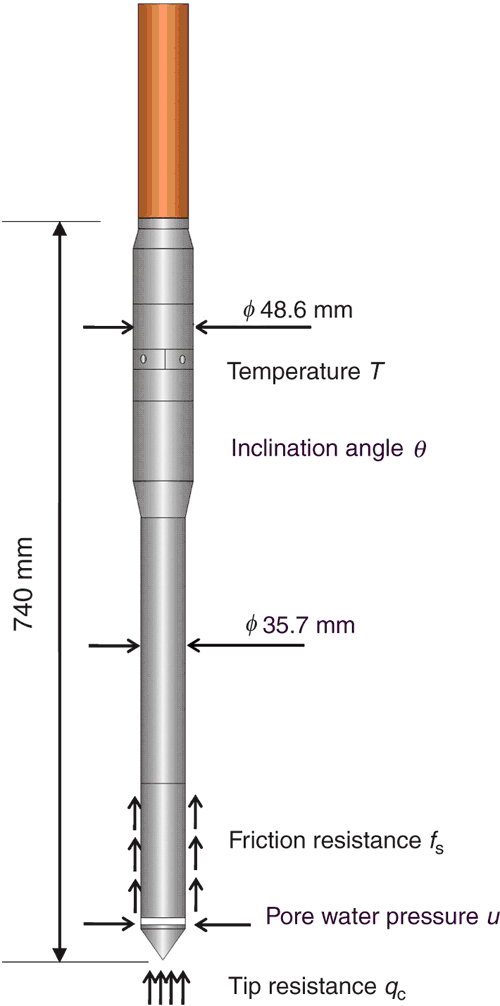
An example of a CPT probe, which is used all over the world, is shown in Figure 2. It has three main sensors: two load cells for detecting friction and tip resistance and a sensor to measure pore water pressure. The probe is pushed into the ground using a hydraulic jack with a penetration speed of 2 cm/s. Geotechnical parameters such as N-value and soil types (sand, silt, clay, etc.) can be evaluated from the sensor measurements.
|
We used a truck-mounted CPT that employs the truck’s own mass as a counterweight. The CPT truck moves easily from one investigation point to the next and carries out the operation without requiring special procedures such as setting up anchor pillars to provide the necessary counter weight. In this research, we used a crawler-type CPT truck for the investigation. The truck itself weighed 8 tons.
Using the CPT data, we created very detailed (almost 3D) soil profiles of the area. Figure 3 presents an example of the soil profiles, taken along the line A-A’ shown in Figure 1.

|
Figure 3 shows that sand fill (Fs) overlies silty clay (Ac). The thickness of the sand fill ranges from ~2 m to 6 m, and the thickness of the silty clay (Ac) varies from 0 m to 14 m. Maps of the thicknesses of the sand fill (Fs) and the silty clay (Ac), and the depth of the water table are shown in Figures 4, 5 and 6, respectively. The sand fill is thickest in the southern and north central parts of the Hinode area. The silty clay (Ac) is thickest in the south, where the water table is shallowest.

|

|

|
Liquefaction risk analysis using thickness and depth of the liquefiable layer
We present two damage maps showing the extent of structural damage of building in Figure 7 (The Geological Society of Japan, 2013) and the distribution of sand boils in Figure 8 (Itako City, 2014).

|

|
Comparing the damage maps in Figures 7 and 8, and the three maps that detail the thickness of the sand fill (Fs), silty clay (Ac), and water table depths presented in Figures 4–6, it can be seen that the areas where the sand fill (Fs) is thicker and the depth of the water table is shallower coincide well with zones that suffered larger liquefaction damage. Liquefaction damage is generally more prominent on thick sand with a shallow water table. Focusing on the thickness of the liquefiable layer and the depth of the water table, we apply a simple method for evaluating liquefaction risk that uses the thicknesses of the liquefiable and non-liquefiable layers (Architectural Institute of Japan, 2008) as depicted in Figure 9. If we know the geological structure and can estimate the thickness or depth of the liquefiable layer and water table, we can estimate H1 (the thickness of the non-liquefiable layer) and H2 (the thickness of the liquefiable layer). When all the layers are deemed to be liquefiable (case (a) in Figure 9) and the water table is located in the estimated liquefiable layer, H1 is the depth of the water table and H2 equals the total thickness of the estimated liquefiable layer minus H1. When a non-liquefiable layer covers the liquefiable layer (case (b) in Figure 9) and the water table is located in the estimated non-liquefiable layer, H1 is the estimated thickness of the non-liquefiable layer and H2 is the estimated thickness of the liquefiable layer. When the water table is located in a layer that is deemed to be liquefiable and lies underneath a non-liquefiable layer (case (c) in Figure 9), H1 is the depth of the water table and H2 is the sum of the thicknesses of the estimated non-liquefiable and liquefiable layers minus the depth of the water table.

|
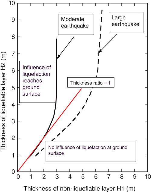
If we have enough information about the near-surface geological structure to determine H1 and H2 as in Figure 9, we can predict the influence of liquefaction at the ground surface using the criteria shown in Figure 10 (e.g. Architectural Institute of Japan, 2008; Hitomi, 2002). Figure 10 indicates that, for a moderate earthquake, when H2 is sufficiently larger than H1 above the black line, the influence of liquefaction will reach the ground surface.
|
We define the ratio of the layers as r = H2/H1. When this ratio (r) exceeds 1 and the non-liquefiable layer is less than 3 m in thickness in moderate earthquakes (assumed surface acceleration is 200 Gal), liquefaction appears to influence the ground surface. For large earthquakes (assumed surface acceleration is 300 Gal), we define the layer ratio as r = 1.25 × H2/H1. When this ratio (r) exceeds 1 and the non-liquefiable layer is less than 6 m in thickness, the influence of liquefaction appears on the ground surface. This method may be useful in evaluating the liquefaction risk of wide areas where the geological structure is well known, such as reclaimed land.
A case study of liquefaction risk analysis using the thickness and depth of the liquefiable layer in the Hinode area
As is known from the soil profile in the Hinode area shown in Figure 3, sand fill (Fs) overlies silty clay (Ac) and the water table is shallow. This geological structure corresponds to the case (a) in Figure 9. We assumed the top of the non-liquefiable layer (H1) to be at the depth of the water table, and the thickness of the liquefiable layer (H2) to be the thickness of the sand fill minus the depth of the water table. Thus, if we know the thickness of the sand layer and the depth of the water table, we can calculate the liquefaction risk using the H2/H1 ratio.
In order to know the thickness of the sand fill (Fs) and to calculate the liquefaction risk based on the ratio of H2/H1, we tried two methods. One is a method using CPT data for 143 points, from which we compiled a liquefaction risk map based on the H2/H1 ratio, and the other is a method using 2D electric resistivity survey, from which we obtained liquefaction risk based on the H2/H1 ratio for specific points. In the method using the CPT data, we calculated H2/H1 ratios using the thickness of the fill sand (Figure 4) and the depth of the water table (Figure 6) obtained from the CPT data.
In the electric resistivity method, we carried out 2D electric resistivity surveys in the Hinode area, taking measurements at six locations, mainly in public parks or schoolyards. Geophysical prospecting methods, including the electric resistivity survey method, can delineate subsurface geological structure such as the depth and thickness of liquefiable sand layers, from the surface of the ground. Therefore, we designed our electric resistivity surveys to image geological structures from the surface to ~10 m in depth with a 30 m measurement line.
A Wenner array configuration of 46 electrodes at 1 m intervals was used in the electric resistivity survey. We employed a McOHM Profiler-4 with a power amplifier (OYO Corporation) as the data acquisition system, and we used 8 mm diameter stainless steel rods as electrodes. We stuck the electrodes into the ground and checked that the current value was always over 100 mA for each of the current dipoles. The raw data were inverted by using Res2Dinv (Geotomosoft Solutions, Penang, Malaysia).
To detect the water table, we used a small-diameter rod that we pushed into the ground using a small vibrating hammer, and a very simple water table checker with electrodes at the bottom of a 3 m long stick.
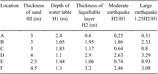
Figure 11 presents an example of the electric resistivity cross section at the point D in Figure 12. Higher resistivity indicates fill sand and lower resistivity shows the presence of silty clay below 4 m in depth. The water depth of 1.1 m was obtained by direct rod measurement from the surface. Therefore, H1 equals 1.1 (water table depth) and H2 equals 2.9 m (4 m−1.1 m), and the thickness ratio is calculated as 2.63 at this location. In Figure 10, this value is plotted above the black line, indicating that the influence of liquefaction would be expected to reach the ground surface. Table 1 shows the thickness ratio H2/H1 obtained from the electric resistivity surveys.

|

|
|
Figure 12 is a map of the thickness ratios (H2/H1) obtained from the CPT data for 143 points and those from the electric resistivity surveys for six locations denoted by letters A to F in Figure 12. The depth precision of the electric resistivity survey is at most 0.5 m. However, in spite of this low resolution, the thickness ratios are a good match with those derived from the CPT data.
Figures 7, 8 and 12 show a similarity in the distributions of the actual and the predicted damage. The locations with thickness ratios less than 1 agree with the locations that did not suffer liquefaction damage. In addition, estimates from the electric resistivity data agree with those from the CPT data.
Comparison of liquefaction potential analysis using thickness and depth of the liquefaction layer and conventional method
The liquefaction resistance factor (FL) and liquefaction potential index (PL) procedures are the most conventional methods for evaluating liquefaction. They both involve the use of CPT data. The FL and PL methods are based on Iwasaki et al. (1978). The FL method is similar to the ‘simplified procedure’ developed by H. Bolton Seed and his colleagues (e.g. Seed and Idriss, 1971; Youd et al., 2001). The procedure, which was originally based on standard penetration testing (SPT), has been extended to include CPT (Robertson and Wride, 1997). The PL method was developed in Japan to estimate the potential for liquefaction to cause foundation damage at a site (e.g. Iwasaki et al., 1982; Holzer et al., 2002). Iwasaki et al. (1982) concluded that severe liquefaction is likely to occur at sites with PL values greater than 15 and unlikely at sites with PL less than 5. Toprak and Holzer (2003) used CPT soundings at historic liquefaction sites in California to evaluate the predictive capability of the PL method. In this study, we employed the guidelines of the Architectural Institute of Japan (1988), which is the most popular analysis in Japan.
The FL method calculates the FL value as the ratio of R (liquefaction resistance of the soil) to L (shearing stress ratio of the soil). When FL is less than 1.0, the soil is deemed liquefiable. To estimate the inputs R and L, researchers commonly use the N-value or tip resistance measured by CPT. In addition, to evaluate liquefaction, the ground acceleration on the ground surface, the fine fraction of the soil (weight fraction of soil particles whose grain size is smaller than 75 μm), and the depth to the water table are required. Typical values assumed for ground acceleration on the ground surface during earthquakes are 200 Gal for a moderate earthquake and 300 Gal for a large earthquake in Japan. The larger value, 300 Gal, corresponds to the maximum ground acceleration observed in the Western Tottori prefecture earthquake, Japan, in 2000. In FL liquefaction analyses, the liquefaction resistance factor is calculated at each depth.
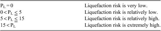
A PL value is often used as a liquefaction indicator in Japan. The PL value is the integral from the surface to a depth of 20 m of the value of FL, multiplied by a weight factor for depth. As shown in Table 2, if the PL value is less than 5, the liquefaction risk is low, while for PL values over 15, the liquefaction risk is extremely high.
|
We calculated FL values at each depth based on CPT data and also evaluated PL for the points investigated. The ground acceleration used to calculate the FL value is 200 Gal and the earthquake magnitude is 9.0. These values correspond to the ground acceleration observed near Itako City and the magnitude of the 2011 Great Eastern Japan Earthquake. Figure 13 is a map of PL values calculated from the CPT data for the Hinode area.

|
All over the Hinode area, PL values exceed 5, so the entire area is classified as ‘Liquefaction risk is relatively high’ or ‘Liquefaction risk is extremely high’. PL values are particularly high in the south, north, and north-east parts.
Figures 7 and 8 show that the largest liquefaction damage occurred in the southern part of the Hinode area. Comparing the PL map in Figure 13 to these figures, we see that major damage actually occurred in the central part of the southern area even though the PL values there are lower (see Figure 13). Thus, there are differences between the PL map and the actual damage. It must be kept in mind, however, that the PL values are over 5, indicating ‘Liquefaction risk is relatively high’, meaning that damage in those areas is not unexpected.
Conclusions
AIST carried out high-density CPT at 143 points in the Hinode area, Itako City, Ibaraki Prefecture, Japan. The Hinode area was extensively damaged by the Great Eastern Japan Earthquake in 2011. We demonstrate a method for analysing liquefaction risk based on the thickness and depth of the liquefiable layer estimated by electric resistivity data. The results of the analysis using the thickness ratios from the electric resistivity cross section and the CPT data agreed well with each other. A thickness ratio map produced also matched the real damage very well.
We also analysed the major liquefaction potential using the conventional FL and PL methods. The PL values in the Hinode area were greater than 5 across the entire area, showing that the liquefaction risk is relatively high overall, but the PL distribution and actual damage did not agree well in some parts of the study area. The reason may come from the PL analysis using the FL data for the silty layers because FL analysis relates to the evaluation of the fine fraction of soil.
The thickness analysis method is based on the liquefiable layer structure, which can be estimated by the geophysical exploration methods such as electric resistivity surveys. If other geophysical prospecting methods such as the capacitive coupled electric resistivity and near-surface EM methods, which are suitable for wide area surveys, can be also applied, this method could be very useful in investigating liquefaction risk, especially for gas and water pipelines buried at shallow depths.
Acknowledgements
The authors wish to thank the people of Itako City for supporting investigations in the Hinode area and DIA Consultants Co. Limited for conducting the cone penetration tests and for their FL/PL analysis, as well as K. Nagao of Sato Kogyo Co., Ltd, for supporting the electric resistivity survey and investigating the depth of the water table. This project was included in Japan’s third supplementary budget for recovery from the 2011 Great Eastern Japan Earthquake disaster.
References
Architectural Institute of Japan, 1988, Recommendations for Design of Building Foundations, 67–71.Architectural Institute of Japan, 2008, Recommendations for Design of Small Building Foundations, 88–92.
Hitomi, T., 2002, Risk Evaluation of Soil Liquefaction for Earthquake Resistant Design of Residential Land, research report of Urban Renaissance Agency, No. 133. [Web document]. Available at http://www.ur-net.go.jp/lab/kiho133/133-09.pdf (accessed 12 May 2016).
Holzer, T. L., Toprak, S., and Bennett, M. J., 2002, Liquefaction potential index and seismic hazard mapping in the San Francisco Bay area, California: Seventh U.S. National Conference on Earthquake Engineering, Theme: Urban Earthquake Hazard, Boston, II 1699 1706
Itako City, 2014, A report on the project of liquefaction measures at Hinode area, Chapter 1, Outline. [Web document]. Available at <http://www.city.itako.lg.jp/cms/data/doc/1385542213_doc_1_0.pdf> (accessed 29 September 2015).
Iwasaki, T., Tatsuoka, F., Tokida, K., and Yasuda, S., 1978, A practical method for assessing soil liquefaction potential based on case studies at various sites in Japan: Proceedings of the 2nd International Conference on Microzonation, San Francisco, 885–896.
Iwasaki, T., Tokida, K., Tatsuoka, F., Watanabe, S., Yasuda, S., and Sato, H., 1982, Microzonation for soil liquefaction potential using simplified methods: Proceedings of the 3rd International Earthquake Microzonation Conference, Seattle, 1319–1330.
Komatsubara, J., Mizuno, K., Ishihara, Y., Ishihara, T., Yasuhara, M., Inamura, A., and Kazaoka, O., 2014, Relationship between liquefaction and geology in the downstream basin of the Tone River: Reports of research and investigation on multiple geological hazards caused by huge earthquakes, GSJ Interim Report, 245–272.
Mitsuhata, Y., Mizuno, K., Jinguuji, M. Matsuoka, M., 2014, Summary of investigation and evaluation study on liquefaction risk in the 2011 Great East Japan Earthquake disaster: Reports of research and investigation on multiple geological hazards caused by huge earthquakes, GSJ Interim Report, 173–177.
Robertson, P. K., and Wride, C. E., 1997, Cyclic liquefaction and its evaluation based on the SPT and CPT, in T. L. Youd, and I. M. Idriss, eds., Proceedings of National Center for Earthquake Engineering Research Workshop on Evaluation of Liquefaction Resistance of Soils, Technical Report No. NCEER-97–0022: NCEER, 41–87.
Seed, H. B., and Idriss, I. M., 1971, Simplified procedure for evaluating soil liquefaction potential: Journal of the Geotechnical Engineering Division, 97, 1249–1273
The Geological Society of Japan, 2013, [Web document in Japanese]. Available at http://www.geosociety.jp/hazard/content0079.html (accessed 29 September 2015).
Toprak, S., and Holzer, T. L., 2003, Liquefaction potential index: a field assessment: Journal of Geotechnical and Geoenvironmental Engineering, 129, 315–322
| Liquefaction potential index: a field assessment:Crossref | GoogleScholarGoogle Scholar |
Youd, T. L., Idriss, I. M., Andrus, R. D., Arango, I., Castro, G., Christian, J. T., Dobry, R., Liam Finn, W. D., Harder Jr, L. H., Hynes, M. E., Ishihara, K., Koester, J. P., Liao, S. S. C., Marcuson, W. F., Marting, G. R., Mitchell, J. K., Moriwaki, Y., Power, M. S., Robertson, P. K., Seed, R. B., and Stokoe, K. H., 2001, Liquefaction resistance of soils: summary from the 1996 NCEER and 1998 NCEER/NSF workshops on evaluation of liquefaction resistance of soil: Journal of Geotechnical and Geoenvironmental Engineering, 127, 817–833
| Liquefaction resistance of soils: summary from the 1996 NCEER and 1998 NCEER/NSF workshops on evaluation of liquefaction resistance of soil:Crossref | GoogleScholarGoogle Scholar |