

S-wave reflection and surface wave surveys in liquefaction affected areas: a case study of the Hinode area, Itako, Ibaraki, Japan
Toshiyuki Yokota 1 3 Motoharu Jinguuji 1 Yoshiaki Yamanaka 2 Kazunori Murata 21 National Institute of Advanced Industrial Science and Technology, 1-1-1-C7, Higashi, Tsukuba, Ibaraki 305-8567, Japan.
2 SUNCOH Consultants Co. Ltd, 1-8-9, Kameido, Koto-ku, Tokyo 136-8522, Japan.
3 Corresponding author. Email: yokota-t@aist.go.jp
Exploration Geophysics 48(1) 1-15 https://doi.org/10.1071/EG16099
Submitted: 9 August 2016 Accepted: 11 August 2016 Published: 3 October 2016
Abstract
Property damage results from liquefaction that occurs easily in soft sandy layers. Moreover, liquefaction damage tends to be more serious at locations where earthquake ground motions are locally amplified. It is commonly understood that ground stiffness is correlated with S-wave velocity (Vs); in addition, the structure of the local subsurface is important for predicting local earthquake ground motion. Surface wave and S-wave reflection surveys are efficient, non-destructive techniques used to obtain two-dimensional S-wave velocity distributions and to map subsurface structures. In this study, we performed surface wave and S-wave reflection surveys to investigate the Hinode area of Itako, Ibaraki, Japan. This area suffered serious liquefaction damage during the Great Eastern Japan Earthquake of 2011. Using subsurface boundaries imaged by the reflection surveys and the Vs structures obtained by surface wave analyses, it is possible to extrapolate geological and hydraulic information obtained by boring and cone penetration tests (CPTs). The combined information was used to delineate the layer in which liquefaction occurred, identified as an artificial layer of sandy dredged material, formed after 1970. The results of this study confirmed the effectiveness and applicability of geophysical surveys to the evaluation of the liquefaction potential. These methods enable us to predict the spatial distribution of liquefiable soils for future large earthquakes.
Key words: artificial unconformity, Great Eastern Japan Earthquake, liquefaction, reflection method, S-wave, surface wave survey.
Introduction
The Great East Japan Earthquake occurred on 11 March 2011 and caused serious damage to people’s lives and livelihoods, not only through direct damage from the ground motion but also from the subsequent tsunami, land subsidence, and liquefaction. In particular, liquefaction-related damage was experienced across a wide area of eastern Japan. The Tokyo Bay and Tone River downstream regions (Figure 1), the most highly developed and densely populated areas in Japan, were most seriously damaged by liquefaction (Komatsubara et al., 2014b).

|
Estimating the liquefaction resistance of soil is quite important in the civil engineering field, especially in countries with frequent earthquakes (e.g. Japan). Estimates have conventionally been based on bore surveys and on laboratory tests of soil samples. A simplified procedure to estimate the liquefaction resistance of soil using the blow count (N value) of standard penetration tests (SPTs) was first developed by Seed and Idriss (1971). Stark and Olson (1995) determined a relationship between cone penetration test (CPT) tip resistance and liquefaction resistance. These kinds of approaches require invasive methods, such as bore surveys or penetration tests; thus, data are limited to drill-hole or penetration test locations, which provide only sparse spatial coverage.
In the Tokyo Bay and Tone River downstream region, both widespread earthquake damage and the high population and infrastructure density pose significant difficulties for using invasive methods. In such cases, simplified procedures for evaluating liquefaction resistance based on S-wave velocity (Vs) are applicable (Seed et al., 1983; Tokimatsu and Uchida, 1990; Andrus and Stokoe, 1997; Andrus et al., 1999; Andrus and Stokoe, 2000; Kayabali, 1996; Juang et al., 2001; Lin et al., 2004; Kayen et al., 2013). There are some examples in which evaluation of liquefaction in Japan has been based on Vs (Tokimatsu and Uchida, 1990; Hayashi et al., 2006). The Vs distribution can be obtained by non-destructive geophysical surveys, including reflection, refraction and surface wave surveys, and these can also solve spatial coverage problems because geophysical surveys can acquire data over a wider area, and even from subsurface locations that are difficult to reach using invasive methods (e.g. beneath paved roads).
In this study, we carried out both S-wave seismic reflection and surface wave surveys in the same areas, because each technique has advantages and disadvantages. Seismic reflection surveys are well suited to detecting layer boundaries and have a deeper survey capability. On the other hand, they performed poorly when obtaining information at extremely shallow depths because of their resolution limit. In contrast, surface wave surveys are better suited to assessing extremely shallow regions (< 5 m), although their results show ambiguity in the identification of layer boundaries and they have a limited survey depth. The relatively deeper portions of subsurface structures, which can be imaged by reflection surveys, are useful for predicting the local amplification of earthquake ground motions. The information can be used to predict maximum ground surface acceleration, which is necessary for accurately assessing liquefaction potential using Vs values. The distribution of Vs at shallow depths, which can be obtained by surface wave surveys, is useful for estimating liquefaction potential. By applying both techniques together, we derived more accurate subsurface information.
We performed seismic surveys in Itako, Ibaraki, Japan, with a particular focus on the Hinode area of Itako City, which has suffered from serious and widespread liquefaction damage (Figure 2; Komatsubara et al., 2014b). Our research complements other surveys carried out in the Hinode area, included boring (Itako City, 2014a, 2014b; Kazaoka et al., 2014; Tanabe et al., 2014), trenching (Komatsubara et al., 2014a), and direct-push type surveys (Jinguuji and Nakashima, 2014; Jinguuji and Toprak, 2016) in which measurements were carried out using CPT with several sensors attached to the CPT rod, Ram-sounding, and vibration probe penetration tests (VPT; Jinguuji et al., 2001, 2003, 2006). The basic concept of VPT is forcibly liquefying a liquefiable layer using artificial vibrations, and measuring the accompanying changes in physical properties.

|
We were able to extrapolate geological and hydraulic information obtained by boring and CPT by using the information on subsurface boundaries obtained from the reflection surveys and the Vs distribution obtained from the surface wave analyses as guides. On the basis of our results, the subsurface was classified into multiple layers, among which liquefaction occurred inside the uppermost artificial sandy soil layer, the spatial distribution of which was delineated using the Vs sections. By investigating the relationship between Vs and liquefaction potential, we confirmed that liquefaction prediction using Vs distribution is applicable to this area. The results of this study will assist in future subsurface imaging and liquefaction prediction for areas with limited numbers of drill holes.
Survey area
The Hinode area (Figure 1) was once a lagoon called ‘Uchi-nasaka-ura’. The area was reclaimed in the 1940s in order to increase food production, and was used as water-filled paddy fields for 30 years. During this first land reclamation, an enclosure bank was created to discharge internal water. In the 1970s, further reclamation work was carried out. As a result, the lagoon became desiccated, the land was filled in for use as a housing site. During this second reclamation, sand pumping was used to in-fill the area (i.e. the area was filled with dredged soil sourced from surrounding lakes and rivers using pipes from dredger boats; Kazaoka, 2003; Itako City, 2014a, 2014b). At this time, an artificial unconformity was formed between the natural and artificial (human-made) strata. The artificial unconformity is significant from the viewpoint of geo-hazard prevention. Since artificial strata are younger than natural strata, they are generally unconsolidated and have greater porosity. The boundaries between artificial and natural strata can act as landslide surfaces because of the difference in their properties. When an earthquake occurs, ground motion tends to be amplified more in artificial strata because they are soft and their rigidity is low. Therefore, artificial ground with a high groundwater level is easily liquefied.
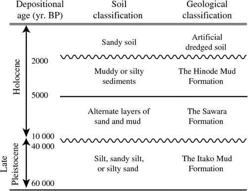
The regional strata that accumulated in the Holocene, include the Sawara Formation, the Hinode Mud Formation, and the artificial sandy dredged soil (Itako City, 2014a, 2014b; Tanabe et al., 2014). Figure 3 shows a schematic stratigraphic column of the Hinode area. The Sawara Formation is composed of alternate layers of sand and mud accumulated during a Holocene glacial retreat (i.e. marine transgression at ~5000–10 000 years BP). The Hinode Mud Formation contains muddy or silty sediments that accumulated during a regression period (~2000–5000 years BP) when the Hinode area was a lagoon. Beneath the Holocene layers (i.e. just below the Sawara Formation) is the Itako Mud Formation, which has a depositional age of about 40 000–60 000 years BP (Late Pleistocene).
|
Three survey lines were run across the Hinode and adjacent areas (Figure 4). Survey line GS13-ITK1 followed a road crossing the central portion of the Hinode area from east to west, while survey lines GS13-ITK2 and GS13-ITK3 ran north to south. The results of boring (Tanabe et al., 2014) and CPT (Jinguuji and Nakashima, 2014; Jinguuji and Toprak, 2016) close to the survey lines were used in this study (Figure 4). Survey lines GS13-ITK1, GS13-ITK2, and GS13-ITK3 were 1236 m, 1395 m, and 1634 m in length, respectively.

|
Data acquisition and processing
Land seismic surveys generally use spiked geophones as receivers. Since they are firmly fixed to the ground, this type of receiver can acquire high quality data; however, in this study we used a land streamer receiver system (Inazaki, 1992). Although the data quality acquired by the land streamer system is generally lower than that of the spiked geophone system, deployment and movement of the whole spread was easier and greatly reduced the data acquisition time.
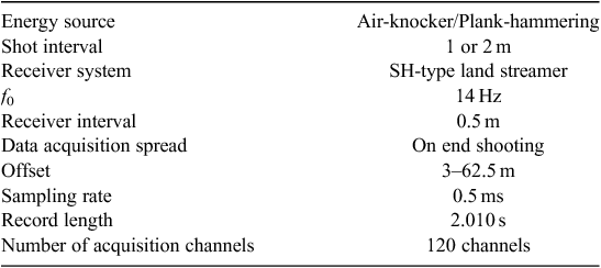
S-wave reflection survey
In the S-wave reflection survey (Table 1), we used a DAS-1 system (OYO-Geospace Co., Houston, TX, USA) for data recording. A horizontal impact perpendicular to a survey line made by a human powered sledgehammer onto a heavy plate was used as the primary SH energy source (i.e. the plank-hammering method). We also used a mechanical source (‘air-knocker’) using compressed air for some portions of the survey line. The standard shot interval was 1 m. For the 0–1000 m segment of survey line GS13-ITK2, and the 0–1030 m segment of survey line GS13-ITK3, the shot point interval was set to 2 m. The standard number of shots at each shot point (vertical stack number) was four. We attached 120 single-channel horizontal geophones perpendicular to a survey line with a natural frequency (f0) of 14 Hz to the land streamer at intervals of 0.5 m. Receiver spread was ‘on end shooting’ and offset coverage was 3–62.5 m. The sampling rate was set to 0.5 ms and the total record length was 2.010 s.
|
We carried out conventional S-wave reflection data processing based on common midpoint (CMP) stacking, and created S-wave reflection sections. In pre-processing, we eliminated surface wave energy and applied a static correction assuming Vs = 160 m/s. Then, we applied a whitening deconvolution filter. The normal moveout (NMO) stacking velocity was obtained by velocity analysis at every 250 m CMP location. The estimated NMO velocity was interpolated in the time-and-space direction, and a two-dimensional NMO stacking velocity table was created. We applied post-stack f-k migration to the NMO-stacked section. For the migration velocity, we used the NMO stacking velocity function smoothed in the survey line direction.
Surface wave survey
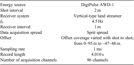
For the surface wave survey (Table 2), we used a DSS12 system (SUNCOH consultants Co., Tokyo, Japan) for data recording and a DigiPulse AWD-1 (GeoSurvey Systems Co., Conroe, TX, USA) as the energy source. This is a weight-drop-type energy source that generates an impulsive P-SV wave by striking a weight accelerated using the elastic energy of a rubber band and the potential energy of the weight, against a plate which is placed on the ground. The shot interval was 2 m and the standard number of shots at each shot point (vertical stack number) was two. We attached 96 single-channel vertical geophones with a natural frequency (f0) of 4.5 Hz to the land streamer at intervals of 1 m. Receivers were in a ‘split-spread’ array, and offset coverage varied from 0–95 m to –47–48 m. The source shots from 0 to 48 m were performed with the position of the land streamer fixed. When the source had finished the 48 m shot position, the land streamer was moved 48 m forward. The sampling rate was set to 1 ms and the total record length was 4.010 s.
|
The surface wave survey data were processed using the multichannel analysis of surface waves (MASW; Park et al., 1999, 2001; Miller et al., 1999; Hayashi et al., 2001). We picked peaks on the colour contour panel of the frequency phase-velocity relationship and obtained the dispersion curves corresponding to the fundamental and higher modes. We used the f-k method (Capon, 1969; 1973) to obtain the relationship between frequency and phase-velocity. First, the f-k method obtained the power spectrum in frequency wavenumber (f-k) domain by the two-dimensional Fourier transform of the acquired data in time distance (t-x) domain, which were sorted into CMP gathers. Next, we obtained the power spectrum in frequency phase-velocity (f-vϕ) domain by converting the wavenumber to the phase-velocity ( ) where vϕ is phase-velocity, ω is angular velocity, and k is wave number. Then we obtained the dispersion curve by picking the maximum amplitude on the power spectrum in the frequency phase-velocity (f-vϕ) domain. Using the picked values as inputs, we obtained the one-dimensional (horizontally layered) Vs structure by a nonlinear least-squares inversion (Hayashi et al., 2001), which simultaneously took fundamental and higher modes into consideration (see Appendix A for the necessity of this step and for justification of including higher modes in the inversion). During the inversion process, Vs models for a 15-layer structure were used. To stabilise the inversion, we kept layer thicknesses at constant values, and only the Vs value of each layer was estimated. The values of Vp, Vs, and density are necessary to define the Rayleigh wave velocity. However, if we try to estimate these values simultaneously, the inversion will become unstable. Moreover, occasionally such a procedure can result in a physically impossible model. Accordingly, in this study, we introduced the assumption that Vp and density values could be calculated from the Vs value in order to stabilise the inversion. Specifically, we estimated Vp and density values from empirical equations between those values and Vs. The equations were obtained by linear regression using experimental data (Sakai, 1968; Kitsunezaki et al., 1990; Society of Exploration Geophysicists of Japan, 1990). Finally, two-dimensional Vs sections were obtained by interpolating between the series of one-dimensional inversion results.
In the inversion procedure, we first created an initial velocity model by extracting rough estimations of the relationships between phase-velocity and depth from the obtained dispersion curve. First, by using the phase-velocity frequency relationship, we converted the phase-velocity into the wavelength at every frequency. Next, we plotted the phase-velocity at the depth corresponding to one-third of its wavelength. In this way, an apparent Vs structure was obtained, which was then used as the initial velocity model of the inversion after spatial smoothing. Finally, we created horizontal-layered initial models with 15 layers. We limited analysis to a maximum depth of 35 m.
Estimation of liquefaction potential by Vs
Seed and Idriss (1971) proposed a simple approach for evaluating liquefaction potential. They introduced the external force of the earthquake as a cyclic stress ratio (CSR) and resistance to liquefaction in a soil deposit as cyclic resistance ratio (CRR), and assumed that the liquefaction occurred when the two values became equal (CRR = CSR). Since subsequent studies have shown that scaling by earthquake magnitude is necessary, a magnitude scaling factor (MSF) was also introduced (Andrus and Stokoe, 1997; Andrus et al., 1999). As a result, the boundary between liquefaction and no-liquefaction can be written using CSR, CSS, and MSF:

There are various ways to give the MSF value, as summarised in Table 2 of Andrus and Stokoe (1997). In this study, we used the values recommended for the upper-bound value in the National Center for Earthquake Engineering Research (NCEER) 1996 workshop (Youd and Idriss, 2001).

where Mw is the moment magnitude.
CSR is generally expressed as:

where σv is total overburden stress, σʹv is initial effective vertical stress, g is acceleration of gravity, amax is peak ground surface acceleration and rd is a shear stress reduction factor to adjust for flexibility of the soil profile. For the value of rd, we used (Liao et al., 1988):

where z is the depth below the ground surface in metres. Many empirical relationships concerning the boundary of liquefaction and no-liquefaction have been suggested using CRR and Vs (Seed et al., 1983; Tokimatsu and Uchida, 1990; Andrus and Stokoe, 1997; Andrus et al., 1999; Andrus and Stokoe, 2000; Kayabali, 1996; Juang et al., 2001; Kayen et al., 2013). In this study, we used the relationship for magnitude 7.5 earthquakes proposed by Andrus and Stokoe (1997), where the fine-grained fraction content is around 20%.

where Vs1 is stress corrected shear wave velocity, defined as:

where Pa is reference stress 100 kPa (approximately atmospheric pressure) and Vs is observed shear wave velocity.
Results
S-wave reflection surveys
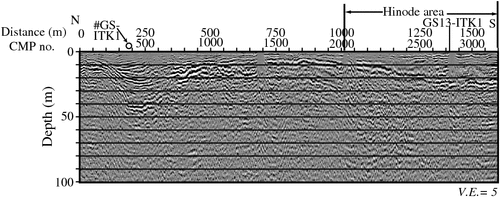
We identified two notable reflection boundaries in the depth section of survey line GS13-ITK1 (Figure 5): (1) a relatively flat reflection boundary at a depth of about 10–15 m, which extended from the western end of the survey line for 700 m; and (2) a slightly west-dipping reflection boundary at a depth of about 15–30 m. A syncline (or pair of anticlines) was observed extending from the western end of the survey line for 500 m, at a depth of around 20–40 m.
|
For Line GS13-ITK2 (Figure 6), the interval between a point at a distance of 1000 m and the southern end of the survey line falls within the Hinode area. A relatively flat reflection boundary at a depth of around 10–15 m, which was observed extending from the northern end of the survey line to 800 m, rapidly increased in depth from the boundary of the Hinode area. From a point with a distance of about 1200 m to the southern end of the line, the deep reflection boundary was observed at a depth of around 50 m.
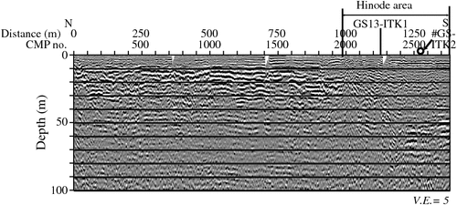
|
For Line GS13-ITK3 (Figure 7), a remarkable syncline (valley-like structure) was observed from the northern end of the survey line to approximately 400 m. The centre of the syncline was located at about 230 m from the northern end of the line, while the depth of the deepest part was about 42 m. Elsewhere, a reflection boundary with a gently changing depth (5–15 m) was observed between distances of 500 and 1500 m. The depth of the boundary gradually increased from the boundary of the Hinode area (at ~1000 m), reaching 25 m depth at the southern end of the survey line.
|
Surface wave survey
For survey line GS13-ITK1 (Figure 8), a layer with a Vs of around 180 m/s was observed at the ground surface. Just beneath the surface layer, a low-velocity layer with a Vs of about 150 m/s or lower was observed. This layer maintained a 15 m thickness from the western end of the survey line for 700 m, but rapidly thinned from this point towards the eastern end of the survey line. Where the low-velocity layer became thinner, the depth to the underlying high-velocity layer (Vs higher than 250 m/s) appeared to decrease.

|
In the northern neighbouring zone of the Hinode area, covering the distance range of 0–1000 m along survey line GS13-ITK2 (Figure 9), the subsurface structure was classified into three parts. In the shallowest layer, a zone with a Vs of 180 m/s was intermittently observed. Below the uppermost zone, a low-velocity layer with a Vs of 150 m/s or slower was observed at depths of 1–5 m; and below a depth of 5 m, a layer with Vs of 250 m/s or higher was observed. The thickness of the second layer was almost constant within the zone. The Hinode area also had a three-layered structure. The uppermost layer (Vs of ~180 m/s) was horizontally continuous. The low-velocity second layer gradually increased in thickness from north to south, and rapidly thickened from ~1100 m.

|
For survey line GS13-ITK3 (Figure 10), a triangle-shaped low-velocity zone (Vs of 150 m/s or lower) was observed in the shallow layer (0–10 m depth) at 0–270 m distance (near the northern end of the survey line). This low-velocity zone was located at almost the same position as a characteristic syncline structure observed in the reflection section of the same survey line (Figure 7). The subsurface structure to the south of this low-velocity layer showed almost the same trend as that observed on survey line GS13-ITK2 (Figure 9). At other points along the survey line, the features of the subsurface structures were similar to those seen in GS13-ITK2. The subsurface structure to the north of the Hinode area showed an almost horizontally layered velocity distribution. The surface layer had a Vs of about 180 m/s, the middle layer was low-velocity, while the deepest layer had a Vs of 250 m/s or more. Horizontal continuity of the surface layer was much better than that observed for survey line GS13-ITK2. In the Hinode area, the low-velocity layer gradually increased in thickness from north to south, rapidly becoming thicker from about 1500 m.

|
Interpretation and discussion
We show the interpretation results for GS13-ITK1, GS13-ITK2 and GS13-ITK3 in Figures 11, 12 and 13, respectively. Each figure consists of three panels: (1) the reflection images obtained from the S-wave reflection survey (Figures 11a, 12a and 13a); (2) the Vs structures obtained from the surface wave survey (Figures 11b, 12b and 13b); and (3) geological interpretation (Figures 11c, 12c and 13c). The figures are vertically exaggerated by a factor of 10. The intersections of the survey lines, borehole locations and positions of CPT are also shown in the figures. The uppermost boundary between artificial sandy soil and the Hinode Mud Formation (broken green line) was interpreted in the Vs sections and overlaid on the S-wave reflection sections, while the other boundaries were interpreted in the S-wave reflection sections and overlaid on the Vs sections. In the Hinode area, the groundwater level is around 1–1.5 m below the ground surface.

|

|

|
GS13-ITK1
As shown in Figure 11a, four reflection boundaries in the depth section of survey line GS13-ITK1 were interpreted. The top reflection boundary (green line) marked the boundary between the artificial sandy soil and the Hinode Mud Formation. The second reflection boundary (blue line) marked the boundary between the Hinode Mud and the Sawara Formations. The third reflection boundary (red line) marked the bottom of the Sawara Formation. We interpreted these three layers as nearly flat structures. Beneath these layers, from the western end of the survey line to a distance of about 300 m, an additional reflection boundary was observed and we interpreted this to represent an internal feature of the Late Pleistocene formation.
For survey line GS13-ITK1, we observed a ground surface layer (the artificial sandy soil) with Vs values of 150 to 180 m/s and qc (CPT tip resistance) values obtained from CPT of more than 5 MPa (Figure 11b). Beneath this layer, we observed a low-velocity zone (the Hinode Mud Formation) with Vs values of 100–150 m/s and qc values of less than 2 MPa. Below the low-velocity layer, we observed a high-velocity zone (the Sawara Formation) with Vs greater than 200 m/s and qc values of over 10 MPa.
GS13-ITK2
The two almost horizontal reflection boundaries corresponding to the bottom of the Hinode Mud Formation and the Sawara Formation were observed from the northernmost end of survey line GS13-ITK2 for about 500 m (Figure 12a). Between distances of 500 and 1000 m, three reflection boundaries were interpreted, consisting of the above-mentioned two reflection boundaries and the bottom of the subjacent Late Pleistocene layer, which dipped slightly to the north. Within the Hinode area, located to the east at a distance of 1000 m and greater, the inclination of the layered structure was large. In particular, the reflection boundary within the Late Pleistocene inclined significantly and its depth reached 50 m at the southern end of the survey line.
In the Hinode area (from 1000 m to the southern end of survey line GS13-ITK2; Figure 12b) we observed a three-layer Vs structure consisting of a relatively high-velocity surface layer (the artificial sandy soil) and subsiding low and high-velocity layers (the Hinode Mud and the Sawara Formations) similar to those observed in survey line GS13-ITK1. Outside the Hinode area, the surface layer was not observed; however, the low- and high-velocity layers were continuous towards the northern end of the survey line.
GS13-ITK3
In the Hinode area (from 1000 m to the southern end of the survey line), three reflection boundaries were interpreted from survey line GS13-ITK3 (Figure 13a). The uppermost reflection boundary, representing the bottom of the dredged sandy soil, was delineated as an almost flat layer. The second reflection boundary, that between the Hinode Mud and the Sawara Formations, and the third reflection boundary, that at the bottom of the Sawara Formation were delineated as west-dipping reflection boundaries. To the north of the Hinode area (distance range of 0–1000 m) an additional reflection boundary was identified, which was observed to continue to the bottom of the characteristic syncline structure. Considering the depositional age of the Sawara Formation (~5000–10 000 years BP), we interpreted that the sediments between this additional reflection boundary and the one above accumulated during the Late Pleistocene. This depositional age was consistent with the results of the boring survey (Itako City, 2014a, 2014b; Tanabe et al., 2014). ‘Basal Gravel Beds of Alluvium’ are widely observed across Japan, including in the Kanto district, and are thought to have accumulated during the Last Glacial Maximum (~21 000 years BP during the Late Pleistocene). Thus, we interpreted the localised bottom reflection boundary to represent the top of the ‘Basal Gravel Beds’. Finally, from the depositional age and its characteristic shape, we interpreted the syncline structure to represent an erosional valley formed in the Pleistocene upland. Subterranean topography of this nature could locally enlarge earthquake ground motion and may be an important factor for future liquefaction predictions.
In the Hinode area (from 1000 m to the southern end of survey line GS13-ITK3; Figure 13b) we observed a three-layer structure similar to that seen in survey lines GS13-ITK1 and GS13-ITK2. The qc and Vs values of each layer were almost the same as those along survey line GS13-ITK1. The thickness of the surface layer increased to the south, and as a result, the top depth of the low-velocity layer appeared to increase slightly to the south. The low-velocity layer also dipped towards the south, and the depth of the high-velocity layer increased accordingly. To the north of the Hinode area, a relatively high-velocity layer was observed at the ground surface within a distance range of 350–800 m. The origin of this high-velocity zone is not the reclamation because the area is located outside of the Hinode area; thus, we distinguished the layer from the dredged sandy soil. Just beneath the surface layer, we observed a low-velocity layer. We also observed a syncline structure filled with low-velocity sediment, extending from the northern end of the survey line to a point with a distance of about 300 m. The deepest point along the low-velocity layer was only approximately 12 m, whereas the depth of the ‘erosional valley’ (Figure 13a) was more than 40 m; however, their horizontal locations were identical. By considering the N values and velocities, we interpreted the low-velocity zone to be the same as that observed in the Hinode area. Over the distance range of ~290–330 m, a notable velocity anomaly was observed. It can be interpreted as a relic of Tone River bank; however in this study, we interpreted this to contain artefacts produced by the inversion procedure as a result of erroneous input values. These data were contaminated by noise (e.g. traffic, a waterway laid under the crossing road), which caused problems when picking the dispersion curve.
Reliability of Vs values obtained from the surface wave survey
At some points, the trends observed in the qc values obtained from CPT did not agree with those of the Vs obtained by our surface wave surveys (e.g. CPT2–26 on survey line GS13-ITK1; Figure 11b). Although the lowest-velocity portion of the low-velocity layer was observed at 2–3 m deep in the surface wave survey results, qc values of less than 2 MPa at CPT2–26 occurred between depths of 3 and 5 m. This discrepancy may be explained by the difference in the survey position, with CPT2–26 located ~8 m south of the survey line GS13-ITK1. According to the result from survey line GS13-ITK3 (Figure 13b), the low-velocity layer at this position dips to the south, and the depth of first appearance of the layer is greater in the south. This observation explains the source of the discrepancy. We conclude that the appearance depth of the silt layer derived from the qc value of CPT2–26 located south of survey line GS13-ITK1 was deeper than that derived from the surface wave survey results.
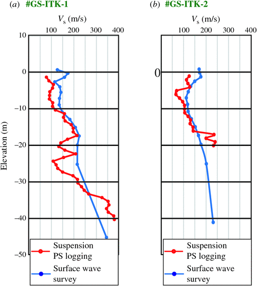
We compared the overall velocity trends for boreholes GS-ITK1 (survey line GS13-ITK3; Figure 14a) and GS-ITK2 (survey line GS13-ITK2; Figure 14b) obtained by suspension PS logging and extracted from the surface wave survey results, and found them to show similar velocity trends; although the surface wave survey results were much smoother. However, the inversion of dispersion curves using the surface wave survey data was unable to reconstruct the local low-velocity anomaly observed in the PS logging results. These two features originated from the differences between the Vs values obtained by the surface wave surveys and those obtained by PS logging. We also found that the surface layer velocities obtained from the surface wave survey results were higher. The distance between the drillholes and the survey line, which were metres apart, may explain this observation. Several other sources of this discrepancy are also possible. The Vs values of the surface layer obtained by the surface wave surveys may also have increased due to the existence of the high-velocity paved road and roadbed, which are just 1 m in thickness but may impact to a depth of up to 5 m. Inaccuracy of the suspension PS logging results in the shallowest layer (especially near the groundwater level) can also be a source.
|
Estimation of liquefaction potential by Vs
We examined the liquefaction potential at CPT6–9 at a depth of 2.5 m (Figure 11b) based on CSR and CRR using Equations 1–6. For the values of total overburden stress (σv) and initial effective vertical stress (σʹv) in Equations 3 and 6, we used the CPT survey result of CPT6–9. The earthquakes used for the examination were the Great East Japan Earthquake in 2011 (Mw = 9.0) and the Chiba-Ken-Toho-Oki (off the eastern coast of Chiba prefecture) Earthquake in 1987 (Mw = 6.1). Plotting Vs values obtained by the surface wave surveys on the horizontal axis and peak ground surface acceleration (amax) on the vertical axis, the boundaries of liquefaction and no-liquefaction were delineated (Figure 15).

|
According to Japan Meteorological Agency (2012) and National Institute for Land and Infrastructure Management (2011), the range of peak ground surface acceleration at CPT6–9 was 50–250 gal and 250–550 gal for the Chiba-Ken-Toho-Oki Earthquake and the Great East Japan Earthquake, respectively. The blue and red arrows on Figure 15 show the range of peak ground surface acceleration corresponding to each earthquake. A broken black line indicates 155 m/s, which is the surface wave survey result for CPT6–9 at a depth of 2.5 m. In addition, we added grey shading to show the Vs range (150–180 m/s) in the artificial sandy dredged soil of the whole Hinode area. The broken black line exists to the right of the blue arrow and to the left of the red arrow. If we assume that Vs values of this area have not changed since 1987, we can conclude from Figure 15 that the point (2.5 m deep at CPT6–9) did not liquefy during the Chiba-Ken-Toho-Oki Earthquake, but did liquefy during the Great East Japan Earthquake. Moreover, most of the grey shaded zone lies to the right of the blue arrow, but some of the dredged soil range is to the left of the red arrow. This implies that most of the artificial sandy dredged soil of the Hinode area did not liquefy during the Chiba-Ken-Toho-Oki Earthquake, but did liquefy during the Great East Japan Earthquake. These conclusions agree well with the geological facts. According to the National Institute for Land and Infrastructure Management and Building Research Institute (2011), only a few limited spots of the Hinode area were liquefied by the Chiba-Ken-Toho-Oki Earthquake. Since CPT6–9 is distant from these liquefied spots, it was assumed that liquefaction did not occur during the Chiba-Ken-Toho-Oki Earthquake at the location of CPT6–9. On the other hand, most of the Hinode area was liquefied during the Great East Japan Earthquake, including the location of CPT6–9.
According to previous research (Tanabe et al., 2014; Komatsubara et al., 2014a), large-scale liquefaction in 2011 occurred mainly in the artificial sandy soils. Our results suggest that the liquefied layer is represented by high Vs zones just beneath the ground surface. It can be assumed that this layer will again liquefy during future large-scale earthquakes. The existence of the silty-muddy Hinode Mud Formation, which lies just beneath the liquefiable artificial sandy soil, also plays a role in the liquefaction behaviour. The low permeability of the formation prevents groundwater from infiltrating the deeper subsurface. Therefore, the water content of the uppermost sandy layer is kept high. Consequently, we can say that the liquefaction probability of the layer is kept high because it is difficult to relieve the excess pore water pressure in the layer, brought about by an earthquake.
Conclusions
We performed S-wave seismic reflection and surface wave surveys in Itako, Ibaraki, Japan, an area that suffered from extensive liquefaction damage during the Great Eastern Japan Earthquake of 2011. We were able to image the subsurface structure and obtain the Vs distribution beneath the Hinode area and its surroundings. The relatively deeper subsurface structures imaged by the reflection surveys are useful for predicting the local amplification of the earthquake ground motion. The Vs distribution obtained by the surface wave survey showed that the survey area is mainly characterised by three layers: a relatively high-velocity surface layer, a low-velocity middle layer, and a high-velocity base layer. By comparing our results with data from drilling and other geological research we were able to interpret these layers as: (1) a relatively high-velocity surface layer (Vs of 150–180 m/s, qc values greater than 5 and N values greater than 10), which represents the dredged sandy soil that experienced significant liquefaction; (2) a low-velocity layer (Vs of 100–150 m/s, qc values lower than 2 and N values lower than 5), which represents the Hinode Mud Formation; and (3) a high-velocity layer (Vs of higher than 200 m/s, qc values greater than 10 and N values greater than 20), which represents the sandy part of the Sawara Formation (alternating layers of sand and mud). The results of this study showed that geophysical (S-wave reflection and surface wave) surveys are economical approaches to quantifying liquefaction predictions with sufficient spatial coverage. Our results showed that Vs distribution can be used to efficiently map the distribution of artificial sandy soil, which is prone to liquefaction.
Understanding the relationship between liquefaction and seismic survey results is challenging. However, the results of this study showed that it is possible to identify the spatial distribution of liquefiable soil by comparing survey results with qc values, N values and other geological data obtained by drilling and CPT. Furthermore, our results suggest that the Vs distribution is applicable for liquefaction prediction.
Acknowledgements
The authors wish to thank the public officers of Itako City, Ibaraki for their cooperation during the seismic surveys. They also wish to thank the liquefaction risk group members of the ‘multiple geological hazards caused by huge earthquakes’ project (National Institute of Advanced Industrial Science and Technology) for their assistance with the interpretation of the survey results. The authors also thank Dr Kiyohide Mizuno for providing PS logging data acquired in the above-mentioned project, and Dr Ikuo Cho for fruitful discussions on the surface wave surveys; two anonymous reviewers for their useful comments and suggestions; and Dr Lindsay Thomas for proof-reading.
References
Andrus, R. D., and Stokoe, K. H., II, 1997, Liquefaction resistance based on shear wave velocity: Proceedings of the National Center for Earthquake Engineering Research Workshop on Evaluation of Liquefaction Resistance of Soils, Technical Report NCEER97–0022, 89–128.Andrus, R. D., and Stokoe, K. H., 2000, Liquefaction resistance of soils from shear-wave velocity: Journal of Geotechnical and Geoenvironmental Engineering, 126, 1015–1025
| Liquefaction resistance of soils from shear-wave velocity:Crossref | GoogleScholarGoogle Scholar |
Andrus, R. D., Stokoe, K. H., II, and Chung, R. M., 1999, Draft guidelines for evaluating liquefaction resistance using shear-wave velocity measurements and simplified procedure, NISTIR6277: National Institute of Standards and Technology, Gaithersburg, MD.
Capon, J., 1969, High-resolution frequency-wavenumber spectrum analysis: Proceedings of the IEEE, 57, 1408–1418
| High-resolution frequency-wavenumber spectrum analysis:Crossref | GoogleScholarGoogle Scholar |
Capon, J., 1973, Signal processing and frequency-wavenumber spectrum analysis for a large aperture seismic array: Methods in Computational Physics, 13, 1–59
Hayashi, K., Suzuki, H., and Saito, H., 2001, Surface wave method using artificial sources – Development and application to civil engineering investigations: Oyo Technical Report, 21, 9–39
Hayashi, K., Tamura, M., Cristian, N., Kikuchi, Y., Ando, K., and Ito, Y., 2006, Seismic investigations in residential area liquefied by Mid Niigata Prefecture Earthquake: Proceedings of the 114th SEGJ Conference, 154–157.
Inazaki, T., 1992, Report of development of ground survey techniques and development of the technology of using subsurface space, No. 3, Ministry of Construction, 2–26.
Itako City, 2014a, A report on the project of liquefaction measures at Hinode area, Chapter 1, Outline. [Web document]. Available at http://www.city.itako.lg.jp/cms/data/doc/1385542213_doc_1_0.pdf (accessed 13 August 2015).
Itako City, 2014b, A report on the project of liquefaction measures at Hinode area, Reference materials. [Web document]. Available at http://www.city.itako.lg.jp/cms/data/doc/1397117186_doc_1_0.pdf (accessed 13 August 2015).
Japan Meteorological Agency, 2012, Report on the 2011 off the Pacific coast of Tohoku Earthquake: Technical report of the Japan Meteorological Agency, no. 133.
Jinguuji, M. and Nakashima, Y., 2014, The liquefaction positional investigations and those estimations along lower reaches of Tone River: Reports of research and investigation on multiple geological hazards caused by huge earthquakes, National Institute of Advanced Industrial Science and Technology (AIST), 319–342.
Jinguuji, M., and Toprak, S., 2016, A case study of liquefaction risk analysis based on the thickness and depth of the liquefaction layer using CPT and electric resistivity data in the Hinode area, Itako City, Ibaraki Prefecture, Japan, damaged by the Great Eastern Japan Earthquake: Exploration Geophysics, ,
Jinguuji, M., Kunimatsu, S., Izumi, H., and Mochizuki, T., 2001, Development of visualization technique of relative density of sand during liquefaction using resistivity and consideration of the results: Journal of Japan Society of Civil Engineers, 680, 201–209
Jinguuji, M., Kunimatsu, S., and Toprak, S., 2003, A monitoring and visualization technique for liquefaction using resistivity: Multidisciplinary Center for Earthquake Engineering Research Technical Report, MCEER-03–0003, 385–394.
Jinguuji, M., Toprak, S., and Kunimatsu, S., 2006, Development of vibration penetration test (VPT) and results of laboratory and field experiments: Proceedings of First European Conference on Earthquake Engineering and Seismology, 1c7.
Juang, C. H., Chen, C. J., and Jiang, T., 2001, Probabilistic framework for liquefaction potential: Journal of Geotechnical and Geoenvironmental Engineering, 127, 670–678
| Probabilistic framework for liquefaction potential:Crossref | GoogleScholarGoogle Scholar |
Kayabali, K., 1996, Soil liquefaction evaluation using shear wave velocity: Engineering Geology, 44, 121–127
| Soil liquefaction evaluation using shear wave velocity:Crossref | GoogleScholarGoogle Scholar |
Kayen, R., Moss, R., Thompson, E., Seed, R., Cetin, K., Kiureghian, A., Tanaka, Y., and Tokimatsu, K., 2013, Shear-wave velocity–based probabilistic and deterministic assessment of seismic soil liquefaction potential: Journal of Geotechnical and Geoenvironmental Engineering, 139, 407–419
| Shear-wave velocity–based probabilistic and deterministic assessment of seismic soil liquefaction potential:Crossref | GoogleScholarGoogle Scholar |
Kazaoka, O., 2003, Lowlands of the Tone River lower stream, reclaimed land of the Tokyo Bay shore: Urban Kubota, 40, 5–13
Kazaoka, O., Mizuno, K., Yoshida, T., Miyachi, Y., Morisaki, M., Tanabe, S., Kagawa. A., Komatsubara, J., Furuno, F., and Komatsubara, T., 2014, Horizons of liquefaction-fluidization strata in the Holocene formation on the Tonegawa Lowland, central Japan, by the 2011 off the Pacific coast of Tohoku Earthquake and paleo-earthquakes: Reports of research and investigation on multiple geological hazards caused by huge earthquakes, National Institute of Advanced Industrial Science and Technology (AIST), 289–296.
Kitsunezaki, C., Goto, N., Kobayashi, Y., Ikawa, T., Horiike, M., Saito, T., Kuroda, T., Yamane, K., and Okuzumi, K., 1990, Estimation of P- and S-wave velocities in deep soil deposits for evaluating ground vibrations in earthquake: Journal of Natural Disaster Science, 9, 1–17
Komatsubara, T., Miyachi, Y., Mizuno, K., Kazahaya, O., Saitou M., and Hosoya, T., 2014a, Trenching survey of liquefaction-fluidization layers: Reports of research and investigation on multiple geological hazards caused by huge earthquakes, National Institute of Advanced Industrial Science and Technology (AIST), 273–288.
Komatsubara, J., Mizuno, K., Ishihara, Y., Ishihara, T., Yasuhara, M., Inamura, A., and Kazaoka, O., 2014b, Relationship between liquefaction and geology in the downstream basin of the Tone River: Reports of research and investigation on multiple geological hazards caused by huge earthquakes, National Institute of Advanced Industrial Science and Technology (AIST), 245–272.
Liao, S. C. C., Veneziano, D., and Whitman, R., 1988, Regression models for evaluating liquefaction probability: Journal of Geotechnical and Geoenvironmental Engineering, 114, 389–411
| Regression models for evaluating liquefaction probability:Crossref | GoogleScholarGoogle Scholar |
Lin, C.-P., Chang, C.-C., and Chang, T.-S., 2004, The use of MASW method in the assessment of soil liquefaction potential: Soil Dynamics and Earthquake Engineering, 24, 689–698
| The use of MASW method in the assessment of soil liquefaction potential:Crossref | GoogleScholarGoogle Scholar |
Miller, R. D., Xia, J., Park, C. B., and Ivanov, J. M., 1999, Multichannel analysis of surface waves to map bedrock: The Leading Edge, 18, 1392–1396
| Multichannel analysis of surface waves to map bedrock:Crossref | GoogleScholarGoogle Scholar |
National Institute for Land and Infrastructure Management, 2011, Analysis of strong-motion earthquake records concerning liquefaction, material of the review meeting of the liquefaction countermeasure technique, Ministry of Land, Infrastructure, Transport and Tourism. [Web document]. Available at http://www.nilim.go.jp/lab/rdg/earthquake/liq.pdf (accessed 12 December 2015).
National Institute for Land and Infrastructure Management and Building Research Institute 2011, Quick report of field survey and research on ‘The 2011 off the Pacific cost of Tohoku Earthquake’ (the Great East Japan Earthquake), Technical Note, National Institute for Land and Infrastructure Management 636, Building research data, 132. [Web document]. Available at http://www.nilim.go.jp/lab/bcg/siryou/tnn/tnn0636pdf/ks063610.pdf (accessed 13 November 2015).
Park, C. B., Miller, R. D., and Xia, J. H., 1999, Multichannel analysis of surface waves: Geophysics, 64, 800–808
| Multichannel analysis of surface waves:Crossref | GoogleScholarGoogle Scholar |
Park, C. B., Ivanov, J., Miller, R. D., Xia, J., and Ryden, N., 2001, Multichannel analysis of surface wave (MASW) for pavement: feasibility test: Proceedings of the 5th SEGJ International Symposium, 25–30.
Sakai, Y., 1968, A study on determination of S-wave’s velocity by soil-penetrometer-test: Bulletin of the Faculty of Engineering, Hokkaido University, 51, 1–8
Seed, H. B., and Idriss, I. M., 1971, Simplified procedure for evaluating soil liquefaction potential: Journal of the Soil Mechanics and Foundations Division, 97, 1249–1273
Seed, H. B., Idriss, I. M., and Arango, I., 1983, Evaluation of liquefaction potential using field performance data: Journal of Geotechnical and Geoenvironmental Engineering, 109, 458–482
| Evaluation of liquefaction potential using field performance data:Crossref | GoogleScholarGoogle Scholar |
Society of Exploration Geophysicists of Japan, 1990, Elastic velocity of soil and rocks – measurements and utilisation: Society of Exploration Geophysicists.
Stark, T. D., and Olson, S. M., 1995, Liquefaction resistance using CPT and field case histories: Journal of Geotechnical Engineering, 121, 856–869
| Liquefaction resistance using CPT and field case histories:Crossref | GoogleScholarGoogle Scholar |
Tanabe, S., Miyata,Y., Nakashima, R., and Mizuno, K., 2014, Results of sediment core analysis of the post-LGM incised-valley fills in the left bank area of the Tone River: Reports of research and investigation on multiple geological hazards caused by huge earthquakes, National Institute of Advanced Industrial Science and Technology (AIST), 297–318.
Tokimatsu, K., and Uchida, A., 1990, Correlation between liquefaction resistance and shear wave velocity: Soil and Foundation, 30, 33–42
| Correlation between liquefaction resistance and shear wave velocity:Crossref | GoogleScholarGoogle Scholar |
Youd, T. L., and Idriss, I. M., 2001, Liquefaction resistance of soils: Summary report from the 1996 NCEER and 1998 NCEER/NSF workshops on evaluation of liquefaction resistance of soils: Journal of Geotechnical and Geoenvironmental Engineering, 127, 297–313
| Liquefaction resistance of soils: Summary report from the 1996 NCEER and 1998 NCEER/NSF workshops on evaluation of liquefaction resistance of soils:Crossref | GoogleScholarGoogle Scholar |
Appendix A
Necessity and justification of including higher modes in the inversion
Figures A-1 and A-2 show numerical examples of frequency and phase-velocity relationships obtained by the f-k method. Figure A-1 shows an example where Vs increases with depth. Figure A-2 shows an example where a low-Vs zone exists and Vs does not increase according to depth. As shown in Figure A-1, the fundamental mode is dominant when Vs increases monotonically with depth. Moreover, there is a normal dispersion trend, where phase-velocity is reduced as frequency is increased. In contrast, as shown in Figure A-2, higher order modes mix when the Vs structure had a velocity inversion zone. In this case, there was an inverse dispersion (anomalous dispersion) trend, where phase-velocity increased as frequency increased.
Figure A-3 shows observed field data examples of the power spectrum in the frequency phase-velocity domain. In Figure A-3, we can observe a mixture of higher order modes and an inverse dispersion trend similar to that in Figure A-2. We found that the observed power spectrum in the frequency phase-velocity domain in Hinode area (Figure A-3) was similar to that of the numerical example with a low-velocity zone (Figure A-2). As a result, we concluded that Vs in the study area does not increase monotonically with depth, and that higher modes should be considered in the inversion process.

|

|

|