

The usefulness of GPS bicycle tracking data for evaluating the impact of infrastructure change on cycling behaviour
Kristiann C. Heesch A C and Michael Langdon BA School of Public Health and Social Work and Institute of Health and Biomedical Innovation, Queensland University of Technology, Victoria Park Road, Herston, Qld 4059, Australia.
B Infrastructure Management and Delivery Division, Department of Transport and Main Roads, Floor 11, 313 Adelaide Street, Brisbane, Qld 4000, Australia.
C Corresponding author. Email: k.heesch@qut.edu.au
Health Promotion Journal of Australia 27(3) 222-229 https://doi.org/10.1071/HE16032
Submitted: 19 April 2016 Accepted: 18 July 2016 Published: 1 September 2016
Abstract
Issue addressed: A key strategy to increase active travel is the construction of bicycle infrastructure. Tools to evaluate this strategy are limited. This study assessed the usefulness of a smartphone GPS tracking system for evaluating the impact of this strategy on cycling behaviour.
Methods: Cycling usage data were collected from Queenslanders who used a GPS tracking app on their smartphone from 2013–2014. ‘Heat’ and volume maps of the data were reviewed, and GPS bicycle counts were compared with surveillance data and bicycle counts from automatic traffic–monitoring devices.
Results: Heat maps broadly indicated that changes in cycling occurred near infrastructure improvements. Volume maps provided changes in counts of cyclists due to these improvements although errors were noted in geographic information system (GIS) geo-coding of some GPS data. Large variations were evident in the number of cyclists using the app in different locations. These variations limited the usefulness of GPS data for assessing differences in cycling across locations.
Conclusion: Smartphone GPS data are useful in evaluating the impact of improved bicycle infrastructure in one location. Using GPS data to evaluate differential changes in cycling across multiple locations is problematic when there is insufficient traffic-monitoring devices available to triangulate GPS data with bicycle traffic count data.
So what?: The use of smartphone GPS data with other data sources is recommended for assessing how infrastructure improvements influence cycling behaviour.
Key words: built environment, evaluation, exercise, physical activity.
Introduction
Transport cycling produces significant benefits to health, traffic congestion, air quality, noise pollution, greenhouse gas emissions and urban liveability.1–4 Health benefits include reduced risk of cardiovascular disease and all-cause mortality.5,6 Most health benefits are due to increases in physical activity, and these benefits far outweigh the health risks from increases in traffic accidents.4,7
Given the benefits, most Australian state governments have strategies to encourage transport cycling. The most effective strategies are those that create supportive built environments.1 These include making improvements in bicycle facilities and road and path connectivity.1 In Europe and North America, the most common intervention to increase cycling rates has been increasing and improving bicycle paths and lanes.8 Countries like Denmark and the Netherlands, which have invested the most in developing the safest bicycle facilities as part of comprehensive suites of measures to create supportive environments, have >25% of their population cycling regularly for transport.9 In contrast, in Australia, which is only starting to use best practice to develop supportive environments, <2% of the population cycles for transport.10 The Ottawa Charter11 and ecological models recognise that a crucial strategy for encouraging health-enhancing behaviour is the creation of supportive environments.
Evaluating outcomes of improving bicycle facilities is difficult due to methodological complexities. Rigorous, randomised controlled trials are challenging to implement due to the lack of settings that can serve as appropriate control groups, priority given to funding facility construction rather than evaluation, and the conduct of evaluations by practitioners rather than researchers.3,12 Therefore, evaluators have used natural experimental, quasi-experimental, cross-sectional and cohort designs, and results have been mixed.12–15 Some studies suggest that the introduction of bicycle infrastructure has increased cycling while other studies have found no change in cycling pre- to post-introduction of new infrastructure. The lack of consistency across studies could be due in part to the reliance on outcome measures that are prone to bias. For example, travel behaviour diaries and surveys are prone to recall, self-selection, and social desirability bias. Objective measures (e.g. bicycle counts recorded by traffic monitoring devices) are limited to certain locations (e.g. on bikeways) and provide no details on cycling routes or purpose.
An alternative data source that may overcome some limitations of traditional data sources is global positioning systems (GPS). Most GPS-based studies of cyclists16–20 recruit participants to wear stand-alone GPS devices for a set time, during which the devices record cycling trips. These devices improve the accuracy of the data collected compared with that collected through self-report measures;21 although, previous researchers21 note that signal problems cause errors in the accuracy and completeness of travel behaviour data from these devices. Also noteworthy is that significant resources are required for purchasing devices, recruiting participants and data processing; as a result, studies typically recruit relatively small samples of cyclists and/or collect data over short time periods.
Few studies have analysed cycling data collected passively on smartphone applications (apps).22,23 GPS-based data from apps are aggregated into big datasets that provide bicycle volumes for large geographic areas. To date, analyses of these data have typically assessed the benefits of GPS systems for revealing cycling behaviour and route preferences.2,23,24 Evaluations show that smartphone GPS systems capture data more cheaply and easily over long time periods and cover larger geographic areas than other data sources but must be used with traditional data sources as GPS systems capture data from self-selected samples.2,22,24,25 Also, with the variety of smartphones available, the quality of GPS sensors can be variable. Evidence of the usefulness of these systems for evaluating the impact of health-promoting interventions, like the provision of supportive environments, has not yet been well researched.
The aim of this study is to evaluate the usefulness of GPS-based data for evaluating the impact of bicycle infrastructure improvements on cycling behaviour. The objectives were to explore the representativeness of the data, geographic coverage, precision of data-point locations, sensitivity of data to changes in behaviour over time in one location, and the differential usage of the app across locations. The final objective was critical to evaluating whether the data could be used to compare cycling behaviour between a location that receives new infrastructure and locations that do not.
Methods
Data sources
The main data source for these analyses was a commercial GPS tracking system. Other sources were bicycle traffic counts and survey data collected for surveillance. The University Human Research Ethics Committee (HREC) assessed this research as meeting the conditions for exemption from HREC review and approval in accordance with section 5.1.22 of the National Statement on Ethical Conduct in Human Research (2007).
GPS data
The Queensland Department of Transport and Main Roads (TMR) commissioned Strava Metro26 to provide GPS tracking information on cycle routes and volumes across Queensland for 2013–2014.27 Strava collects raw GPS data on cycling trips from cyclists who use their own GPS device or the smartphone Strava app to record their trips.12,27 Time, date and travel route are collected. The Strava Metro product removes personal data, aggregates the data as cyclist counts per transport corridor (segment of road or path) and stores the data in a database.28 The data are then attached to corridors on the open street map and displayed as counts on ‘heat’ and ‘traffic route’ volume maps. Heat maps show densities of cycling events whereas volume maps provide numerical counts.
The database included aggregated demographic data (age and gender) for Queensland from 2011–2014;27 cycling purpose (transport or recreation) for 2013 was also provided to TMR.27 Strava determines that a cycling trip is for transport by three methods: users tag a trip as a ‘commute’ trip, trip origin and destination (within certain duration and distance parameters) suggest the trip was for transport, and a fuzzy description-matching process determines from the title given by a cyclist that the trip was for transport.29
Surveillance data
The 2013–2014 Australian Bureau of Statistics’ (ABS) Multipurpose Household Survey included questions on participation in sports and physical recreation over the previous 12 months.30 Respondents were asked to report any activity that they considered to fit within these activity categories. For our analysis, Queensland respondents who reported any cycling activity were included. As previous work suggests that most Queensland cyclists, including transport-only cyclists, cycle for ‘improving fitness’, ‘fun and enjoyment’ and ‘relaxation’,31 we reasoned that respondents who cycled in the previous year would report their cycling as ‘sport and physical recreation’. The data from the survey comprised the largest dataset of cycling behaviour in Australia.
Traffic counts
TMR installed automatic bicycle traffic–monitoring devices on some bikeways in urban areas of Queensland. These were piezoelectric strips, which are metallic strips that generate an electric charge under pressure (details in Section S1 of online supplementary material). Counts recorded by the devices were aggregated into daily, weekly and monthly counts.
Analysis
To assess representativeness, the percentage of cyclists who used Strava in 2014 was divided into age and gender categories. These percentages were weighted to the 2014 projected Queensland population and compared with the percentages of cyclists recorded in the surveillance data.
Next, geographic coverage of Strava data was assessed: Strava heat maps were inspected to assess how widely the data captured cycling behaviour across the state. Second, the precision of cyclists’ exact locations on volume maps was explored. For a given geographic location cyclist counts shown on a volume map were compared to cyclist counts recorded in the raw dataset of counts that Strava uses to produce the volume map. This comparison allowed us to document any errors in plotting counts from the dataset onto the open street map. Next, the sensitivity of the Strava data to changes in cycling behaviour over time in one location was assessed. For locations that received improved infrastructure, heat and volume maps were produced both pre- and post-infrastructure improvement. For each location the pre- and post-improvement maps were compared visually. Last, we assessed whether usage of Strava differed across locations: for a given geographic location, cyclist counts shown on a volume map were compared to traffic counts recorded at the same location from traffic monitoring devices at the same time. The percentage of cyclists recorded in the traffic counts who were Strava users was computed for the location.
Results
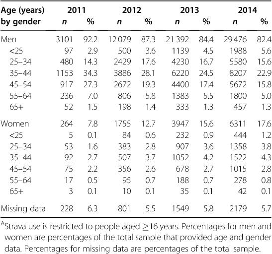
The number of Queensland cyclists who used Strava grew from 3490 in 2011 to 38502 in 2014. Most users were men, but over time the percentage of female users increased (Table 1). Most users were aged 35–44 years. Over one-third of trips in 2013 (31.5%) were transport trips.
|
Representativeness
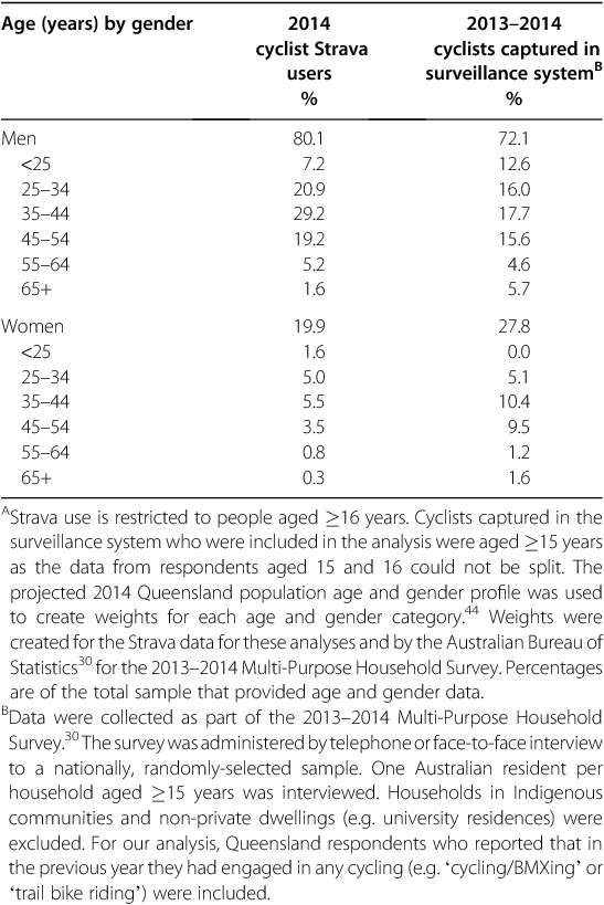
Compared with cyclists captured by ABS for surveillance, more cyclists captured by Strava were men aged 25–65 years (Table 2). Fewer cyclist captured by Strava than by ABS for surveillance were women aged ≥ 35 years.
|
Coverage
Heat maps provided a high level of accuracy in displaying street-level coverage of bicycle trips across the state, including coverage of regional areas (see Fig. S1 in the online supplementary material for a colour version). Such data are not available elsewhere.27 Heat maps also detailed amenities along a route (e.g. public toilet) and end-of-trip facilities (e.g. cafes) frequented by cyclists (Fig. 1b). These data provided a good indication of where cycling was occurring.

|
Precision
There was a drift of +/−10 m when attaching cycling counts onto the open street map. The coding error occurred when a road was split (directional) or ran parallel to, above or below another road ‘type’, such as a motorway overpass or a busway tunnel (where cyclists are prohibited). There were also drifts of +/−10 m on short segments of transport corridors (<10 m). The GPS signal provided the most precise location of cyclists on a segment of a transport corridor that was ≥20 m as the analysis required a ‘buffering tolerance’, which was set at 20 m. For example, if a slip lane (dedicated left-turn lane) was 10 m, the buffer would cover a portion of road as well, which resulted in incorrect counting of cyclists. The error occurred because GPS-enabled smartphones are typically not sub-metre accurate. Fig. 2 shows an example of a coding error. The error can be seen by comparing Fig. 2a to Fig. 2b (see Fig. S2 for a colour version). Also noted were ‘black spots’, where GPS signals were not recording and thus cyclist counts were under-reported.

|
Changes in cycling could be detected on infrastructure improvements, but changes in behaviour were most visible on volume maps of stretches of dedicated bikeway (≥ 200 m). Therefore, the volume maps appear well suited for evaluating changes in behaviour pre- to post-construction of bikeways. Behaviour changes were also detected on upgrades to existing infrastructure.
Sensitivity to changes in cycling behaviour at one location
TMR commissioned detailed maps for locations where new bicycle infrastructure had been built.27 Fig. 3 shows changes between January and March 2014 in weekday cycling pre- to post-expansion of a Brisbane bikeway. A heat map indicated fewer cyclists used the main north to south road, Bowen Bridge Road, after the change than before it, with suggested movement of cyclists to the expanded Victoria Park Bikeway. The Strava Metro product provided cyclist counts from volume maps pre- to post-intervention: the changes in counts on the maps indicated that 60.3% of weekly bicycle trips and 52.4% of cyclists moved from Bowen Bridge Road to the bikeway. Additional mapping of the area surrounding the change showed that cycle counts on quiet streets that connect to the new bikeway experienced small increases in cyclist numbers while cyclist numbers on nearby major roads decreased. Overall, such maps provided an indication that the new infrastructure changed cyclist behaviour.

|
In an evaluation of another expanded bikeway in Brisbane,32 heat and volume maps were inspected to evaluate changes in the number of cycling trips from southern suburbs into the city centre. Cyclist counts on the volume maps suggested a 15% increase over 3 months in cyclist trips from the southern suburbs into the city pre- to post-opening of the expanded bikeway. Heat maps showed 3-month decreases in cycling trips being made on other major cycling routes into the city centre pre- to post-opening of the bikeway expansion.
Changes in cycling behaviour as indicated by Strava data could be due to increases in the number of Strava users over time. Large yearly changes were observed between 2011 and 2014. However, such variability may not be evident in shorter timeframes. Evaluating the short-term effect of an infrastructure improvement on cycling behaviour could still be useful for an evaluation. To examine this possibility, 3-month cyclist numbers from volume maps were compared with cyclist traffic counts on corridors that had received no infrastructure upgrades. Examination of transport corridors in Cairns showed that the percentage of cyclists who were captured by traffic counts and using Strava varied little between March and May, 2013. On one road 7.1% of cyclists captured by traffic counts were Strava users at both time periods. On two other roads, the percentage of Strava users decreased slightly over this time, from 5.2–4.7% on one and from 2.5–2.2% on the other. These findings suggest minimal variability in the short term, making Strava data attractive for evaluating short-term changes in cycling behaviour.
Differential usage of the GPS tracking system across locations
There was large variability across transport corridors in the percentage of cyclists who used Strava. For example, Strava data suggested that similar numbers of cyclists travelled daily across two Brisbane bridges (mean n = 26 and n = 31 for Kurilpa Bridge and Toowong Overpass, respectively); however, traffic count data revealed that only 2.7% of cyclists on the Kurilpa Bridge were using Strava while 6.6% of cyclists on the Toowong Overpass were users. These findings suggest that it is not appropriate to use the Strava data to compare the number of cyclists riding at one location with the number riding at another unless adjustments are made in the analysis for the percentages of cyclists who are using Strava at each of the locations. To make such adjustments, data from bicycle traffic counts are needed.
Discussion
This study assessed the usefulness of Strava cycling tracking data for evaluating the impact of improved bicycle infrastructure on cycling behaviour. GPS tracking data have been useful for examining cycling behaviour previously.2,16–20,22,23,33–35 Our findings extend this research by showing that Strava data are useful for evaluating the impact on cycling of infrastructure improvement at a single location but that Strava data are problematic for making inferences about differential changes in cycling across a region without adjustment for differential Strava use. Moreover, the findings support previous research2,22,25,36 that indicated smartphone GPS data like those from Strava should be triangulated with other data sources.
Compared with population-level survey data from cyclists, middle-aged men who cycled for recreation were over-represented among Strava users. Likewise, US researchers found fewer female than male cyclists used a bicycle smartphone app, compared with the proportion reporting cycling on a population-level survey.23 Other US researchers found that middle-aged men were the main Strava users.22 Therefore, generalising the findings to the greater cycling population is not appropriate. Use of other data sources along with Strava data can help with capturing cycling behaviour from a broader population of cyclists.
For example, Strava data can complement data collected from intercept surveys. Intercept surveys are brief surveys administered to cyclists at events or by stopping them while they are cycling. Recent work41 suggests that combining Strava data with intercept survey data results in a more rigorous evaluation of the impact of infrastructure improvements on cycling behaviour than would the use of either data source alone. Intercept surveys are useful for capturing individual demographic and trip details (e.g. trip origins and destinations, cycling frequency)37 not available from Strava. These surveys can also collect data from a greater diversity of cyclists than can Strava. However, trip data collected from these surveys require expensive and time-consuming manual geo-coding. Consequently, survey data collection is limited to specified time periods. In contrast, Strava collects data automatically and continuously, and geo-coding of trip data is automated. However, as found in other studies that used smartphone GPS technology,21,23,45,46 our study found errors in attaching GPS data to the open street map, which limits the ability of GPS technology to precisely locate cyclists geographically. Given the strengths and limitations of each data source, we recommend that the two be used together for evaluation.
Strava data can complement data from travel and targeted surveys. Surveys can be administered to random samples of a population for making population-level inferences. They can also provide details about residents and their travel patterns, and targeted surveys can collect data on attitudes about, and motivations for, active transport.37 For example, in US16 and Australian19 studies, participants wore a GPS device and completed surveys about their travel patterns and attitudes. Surveys though are prone to self-report biases, and, like intercept surveys, usually only capture behaviour at single time points, as they are too expensive for routine data collection.37 However, when survey data are collected from the same people over time, individual-level change can be assessed. In contrast, Strava users can ‘opt-in’ and opt-out’ at any time,22 and thus some cyclists recorded pre-intervention may not be the same recorded post-intervention. Indeed, a study that used another smartphone app25 found that only a few people tracked large numbers of cycling events over 2.5 years. Our findings indicate little variability in Strava use over the short-term (3 months), and thus Strava appears to be appropriate for examining short-term changes. Unlike survey data, Strava only provides data on cycling trips, not on cyclists, and it may not be clear from evaluations that rely on Strava data if increases in cycling trips reflect increases in the number of cyclists who make trips or increases in the frequency of cycling trips made by current cyclists. Due to privacy restrictions, detailed metadata are not available in Strava. Previous researchers have suggested that for use in public health planning, features that would allow for the recording of metadata would improve the accuracy of Strava data.22 Notably, research with dedicated GPS devices16–20 or that recruit participants into a study that uses a study app23,24 can overcome this limitation by gaining participant permission to collect and release individual-level. Overall, our findings suggest that Strava maps can indicate where cycling is happening and if it is changing in the short term at a location, and survey data can indicate characteristics of cyclists and their motivations for cycling.
In this study, Strava data were cross-referenced with bicycle traffic count data, which are available from most Australia transport departments. Other researchers have combined the data from GPS devices and traffic counts for assessing route choices.16 These data are useful for evaluations as they are accurate38 and sensitive to changes in cycling behaviour.39 However, monitoring devices are not ubiquitous across Australia. In contrast, Strava counts were found in the study to provide state-wide, street-level data on cycling behaviour. Thus, Strava data can be used to indicate changes in cycling in areas where monitoring devices are not present. The study also found that to use Strava data to compare changes in cycling across transport corridors, data from monitoring devices on these corridors are critical. The traffic counts they produce can be used to adjust Strava counts based on differential use of Strava across corridors.
Limitations of this study include the reliance on Strava. Other apps offered internationally include MapMyRide40 and Cyclemeter.42 Apps have also been developed for local use (Cycle Tracks, AggieTrack, and Cycle Atlanta in the US; Mon Reso Velo in Canada; RiderLog in Australia).2,23,43 Strava is the only company providing such data globally. Currently, the incentives built into Strava (belonging to a social media cycling community; speed competitions among users)27 are most likely to encourage use by only the most enthusiastic, regular cyclists.22 Another limitation is the reliance on a survey for comparison with GPS tracking data. The survey requires respondents to recall behaviour over one year, which can result in recall bias, and as with all surveys, behaviour is self-reported. However, these data were collected from a large random sample of residents. Such data have been used previously to assess bias of data generated from GPS users23 as no other data on population-levels of cycling are available.
Conclusion
This study suggests that smartphone GPS data are useful for evaluating the impact of improved infrastructure on cycling behaviour at one location. Using these data to evaluate differential changes in cycling behaviour across locations is problematic when there is an insufficient number of traffic-monitoring devices available to triangulate the GPS data with bicycle traffic count data. We recommend that smartphone GPS data be used in combination with existing data sources because each has its own inherent strengths and limitations. Triangulating Strava data with other data sources can enhance our understanding of the influence of the improved infrastructure on cycling behaviour.
Acknowledgements
We are grateful to the Queensland Department of Transport and Main Roads (TMR) for supporting this work, with a special thank-you to Adam Rogers, Director (Cycling Program). We wish to thank Strava for providing TMR with the Strava Metro product for analysis. Special thanks and acknowledgement to Brian Riordan of Strava Inc. for providing technical clarification about the Strava Metro product.
References
[1] Litman T. Evaluating active transport benefits and costs: guide to valuing walking and cycling improvements and encouragement programs. Victoria, Canada: Victoria Transport Policy Institute; 2015.[2] Figliozzi M, Blanc B. Evaluating the use of crowdsourcing as a data collection method for bicycle performance measures and identification of facility improvement needs. Salem, Oregon: Oregon Department of Transportation and Federal Highway Administration; 2015.
[3] Garrard J. Evaluating cycle promotion interventions. In Bonham J, Johnson M, editors. Cycling futures. (pp. 429–52). Adelaide: University of Adelaide Press; 2015.
[4] Götschi T, Garrard J, Giles-Corti B (2016) Cycling as a part of daily life: a review of health perspectives. Transport Rev 36, 45–71.
| Cycling as a part of daily life: a review of health perspectives.Crossref | GoogleScholarGoogle Scholar |
[5] Garrard J, Rissel C, Bauman A. Health benefits of cycling. In Pucher J, Buehler R, editors. City cycling (pp. 31–55). Cambridge, MA: MIT Press; 2012.
[6] Kelly P, Kahlmeier S, Götschi T, Orsini N, Richards J, Roberts N, et al (2014) Systematic review and meta-analysis of reduction in all-cause mortality from walking and cycling and shape of dose response relationship. Int J Behav Nutr Phys Act 11, 132
| Systematic review and meta-analysis of reduction in all-cause mortality from walking and cycling and shape of dose response relationship.Crossref | GoogleScholarGoogle Scholar | 25344355PubMed |
[7] Mueller N, Rojas-Rueda D, Cole-Hunter T, de Nazelle A, Dons E, Gerike R, et al (2015) Health impact assessment of active transportation: a systematic review. Prev Med 76, 103–14.
| Health impact assessment of active transportation: a systematic review.Crossref | GoogleScholarGoogle Scholar | 25900805PubMed |
[8] Pucher J, Buehler R, Seinen M (2011) Bicycling renaissance in North America? An update and re-appraisal of cycling trends and policies. Transport Res A-Pol 45, 451–75.
[9] Koorey G. Spaces for cycling. In Bonham J, Johnson M, editors. Cycling futures (pp. 251–82). Adelaide: University of Adelaide Press; 2015.
[10] Australian Bicycle Council. Australian Census 2011 Travel to work by bicycle only. Sydney: Australian Bicycle Council; 2013.
[11] World Health Organization. The Ottawa Charter for Health Promotion. Geneva, Switzerland: WHO; 2016 Available from: http://www.who.int/healthpromotion/conferences/previous/ottawa/en/. [Verified 31 March 2016].
[12] Petrunoff N, Rissel C, Wen LM (2016) The effect of active travel interventions conducted in work settings on driving to work: a systematic review. J Transp Health 3, 61–76.
| The effect of active travel interventions conducted in work settings on driving to work: a systematic review.Crossref | GoogleScholarGoogle Scholar |
[13] Pucher J, Dill J, Handy S (2010) Infrastructure, programs, and policies to increase bicycling: an international review. Prev Med 50, S106–25.
| Infrastructure, programs, and policies to increase bicycling: an international review.Crossref | GoogleScholarGoogle Scholar | 19765610PubMed |
[14] Rissel C, Greaves S, Wen LM, Crane M, Standen C (2015) Use of and short-term impacts of new cycling infrastructure in inner-Sydney, Australia: a quasi-experimental design. Int J Behav Nutr Phys Act 12, 129
| Use of and short-term impacts of new cycling infrastructure in inner-Sydney, Australia: a quasi-experimental design.Crossref | GoogleScholarGoogle Scholar | 26444001PubMed |
[15] Scheepers CE, Wendel-Vos GCW, den Broeder JM, van Kempen EEMM, van Wesemael PJV, Schuit AJ (2014) Shifting from car to active transport: a systematic review of the effectiveness of interventions. Transport Res A-Pol 70, 264–80.
[16] Broach J, Dill J, Gliebe J (2012) Where do cyclists ride? A route choice model developed with revealed preference GPS data. Transport Res A-Pol 46, 1730–40.
[17] Casello JM, Usyukov V (2014) Modeling cyclists’ route choice based on GPS data. Transport Res Rec 2430, 155–61.
| Modeling cyclists’ route choice based on GPS data.Crossref | GoogleScholarGoogle Scholar |
[18] Dill J (2009) Bicycling for transportation and health: the role of infrastructure. J Public Health Policy 30, S95–110.
| Bicycling for transportation and health: the role of infrastructure.Crossref | GoogleScholarGoogle Scholar | 19190585PubMed |
[19] Johnson M, Chong D, Carroll J, Katz R, Oxley J, Charlton J. Naturalist cycling study: identifying risk factors for cyclists in the Australian Capital Territory. Report No. 322. Melbourne: MUARC, Monash University, Amy Gillett Foundation; 2014.
[20] Menghini G, Carrasco N, Schussler N, Axhausen KW (2010) Route choice of cyclists in Zurich. Transport Res A-Pol 44, 754–65.
[21] Shen L, Stopher PR (2014) Review of GPS travel survey and GPS data-processing methods. Transport Rev 34, 316–34.
| Review of GPS travel survey and GPS data-processing methods.Crossref | GoogleScholarGoogle Scholar | 1:CAS:528:DC%2BC2cXptlKhsL4%3D&md5=1f8c4be7d910b84e6896a0acd309da4aCAS |
[22] Griffin GP, Jiao J (2015) Where does bicycling for health happen? Analysing volunteered geographic information through place and plexus. J Transp Health 2, 238–47.
| Where does bicycling for health happen? Analysing volunteered geographic information through place and plexus.Crossref | GoogleScholarGoogle Scholar |
[23] Hood J, Sall E, Charlton B (2011) A GPS-based bicycle route choice model for San Francisco, California. Transport Lett 3, 63–75.
| A GPS-based bicycle route choice model for San Francisco, California.Crossref | GoogleScholarGoogle Scholar |
[24] Hudson JG, Duthie JC, Rathod YK, Larsen KA, Meyer JL. Using smartphones to collect bicycle travel data in Texas. UTCM Project 11–35–69. College Station, Texas: Texas Transportation Institute; 2012.
[25] Oksanen J, Bergman C, Sainio J, Westerholm J (2015) Methods for deriving and calibrating privacy-preserving heat maps from mobile sports tracking application data. J Transp Geogr 48, 135–44.
| Methods for deriving and calibrating privacy-preserving heat maps from mobile sports tracking application data.Crossref | GoogleScholarGoogle Scholar |
[26] Strava Inc. Strava Metro: better data for better cities. Hanover, New Hampshire: Strava Inc. 2014. Available from: http://metro.strava.com [Verified 15 July 2016].
[27] Riordan B, Langdon M. Using Strava Metro data for cycling policy and planning. Paper presented at the Asia-Pacific Cycling Congress; 13–16 September 2015. Brisbane, Qld.
[28] Gordon M. What is Strava Metro? Hanover, New Hampshire: Strava Inc.; 2016. Available from https://support.strava.com/hc/en-us/articles/216918877-What-is-Strava-Metro- [Verified 15 July 2016].
[29] Norman G, Kesha N. Using smartphones for cycle planning. Paper presented at the IPENZ Transportation Group Conference; 22–24 March 2015. Christchurch, NZ. Available from http://conf.hardingconsultants.co.nz/workspace/uploads/paper-norman-graham-using-54fe436fb2a3e.pdf. [Verified 31 March 2016].
[30] Australian Bureau of Statistics. Participation in sport and physical recreation, Australia, 2013–14. Canberra: ABS; 2015. Available from: http://www.abs.gov.au/AUSSTATS/abs@.nsf/Lookup/4177.0Explanatory%20Notes12013-14?OpenDocument. [Verified 25 March 2016].
[31] Heesch KC, Sahlqvist S, Garrard J (2012) Gender differences in recreational and transport cycling: a cross-sectional mixed-methods comparison of cycling patterns, motivators, and constraints. Int J Behav Nutr Phys Act 9, 106
| Gender differences in recreational and transport cycling: a cross-sectional mixed-methods comparison of cycling patterns, motivators, and constraints.Crossref | GoogleScholarGoogle Scholar | 22958280PubMed |
[32] Burke M, James B, Heesch K, Washington TL. Analysis and evaluation of use of the V1 and the South East Freeway Bicycleway post-completion of Stage C of the V1. Brisbane: Transport and Main Roads; 2015.
[33] Dill J, Gliebe J. Understanding and measuring bicycling behavior: a focus on travel time and route choice. Portland, OR: Oregon Transportation Research and Education Consortium (OTREC); 2008.
[34] Madsen T, Schipperijn J, Christiansen LB, Nielsen TS, Troelsen J (2014) Developing suitable buffers to capture transport cycling behavior. Front Public Health 2, 61
| Developing suitable buffers to capture transport cycling behavior.Crossref | GoogleScholarGoogle Scholar | 24926478PubMed |
[35] Mavoa S, Oliver M, Witten K, Badland HM (2011) Linking GPS and travel diary data using sequence alignment in a study of children’s independent mobility. Int J Health Geogr 10, 64
| Linking GPS and travel diary data using sequence alignment in a study of children’s independent mobility.Crossref | GoogleScholarGoogle Scholar | 22142322PubMed |
[36] Nitsche P, Widhalm P, Breuss S, Brandle N, Maurer P (2014) Supporting large-scale travel surveys with smartphones – a practical approach. Transport Res A-Pol 43, 212–21.
[37] Langdon M. An evidence-based assessment of the impact of cycling infrastructure in South East Queensland. Paper presented at the Australian Institute of Traffic Planning and Management 2015 National Conference, 28–31 July 2015, Brisbane. Available from http://www.aitpm.com.au/conference/papers/2015-papers/2015-transport-planning [Verified 29 July 2016].
[38] Munro C. Australian cycling participation 2013. Report No. AP-C91–13. Sydney, NSW: Austroads Ltd; 2013.
[39] Rissel CE, New C, Wen LM, Merom D, Bauman AE, Garrard J (2010) The effectiveness of community-based cycling promotion: findings from the Cycling Connecting Communities project in Sydney, Australia. Int J Behav Nutr Phys Act 7, 8
| The effectiveness of community-based cycling promotion: findings from the Cycling Connecting Communities project in Sydney, Australia.Crossref | GoogleScholarGoogle Scholar | 20181019PubMed |
[40] MapMyFitness Inc. MapMyRide. Austin, TX: MapMyFitness; 2016. Available from: http://www.mapmyride.com. [Verified 15 July 2016].
[41] Heesch KC, James B, Washington T, Zuniga K, Burke M Evaluation of the Veloway 1: a natural experiment of new bicycle infrastructure in Brisbane, Australia. J Transport Health In press.
[42] Abvio Inc. Cyclemeter. USA; 2015. Available from: https://abvio.com/cyclemeter. [Verified 15 July 2016].
[43] Pettit CJ, Lieske SN, Leao SZ. Big bicycle data processing: from personal data to urban applications. Paper presented at the XXIII International Society for Photogrammetry and Remote Sensing Conference; 12–19 July 2016. Prague, Czech Republic.
[44] Australian Institute of Health and Welfare. NACDC: Population projections, 2012 (base) to 2027 for all states and territories at Statistical Area Level 2 (SA2) by sex and age. Canberra: AIHW; 2016. Available from http://www.aihw.gov.au/nacdc/population-projections/. [Verified 25 March 2016].
[45] Gong H, Chen C, Bialostozy E, Lawon CTA (2012) GPS/GIS method for travel mode detection in New York City. Comput Environ Urban Syst 36, 131–9.
| GPS/GIS method for travel mode detection in New York City.Crossref | GoogleScholarGoogle Scholar |
[46] Li H, Kulik L, Ramamohanarao R (2015) Robust inferences of travel paths from GPS trajectories. Int J Geogr Inf Sci 29, 2194–222.
| Robust inferences of travel paths from GPS trajectories.Crossref | GoogleScholarGoogle Scholar |