

No. 14 Lands of the Port Moresby–Kairuku Area, Territory of Papua New Guinea
Land Research Surveys
2010(1) 1 - 192
Published: 2010
Abstract
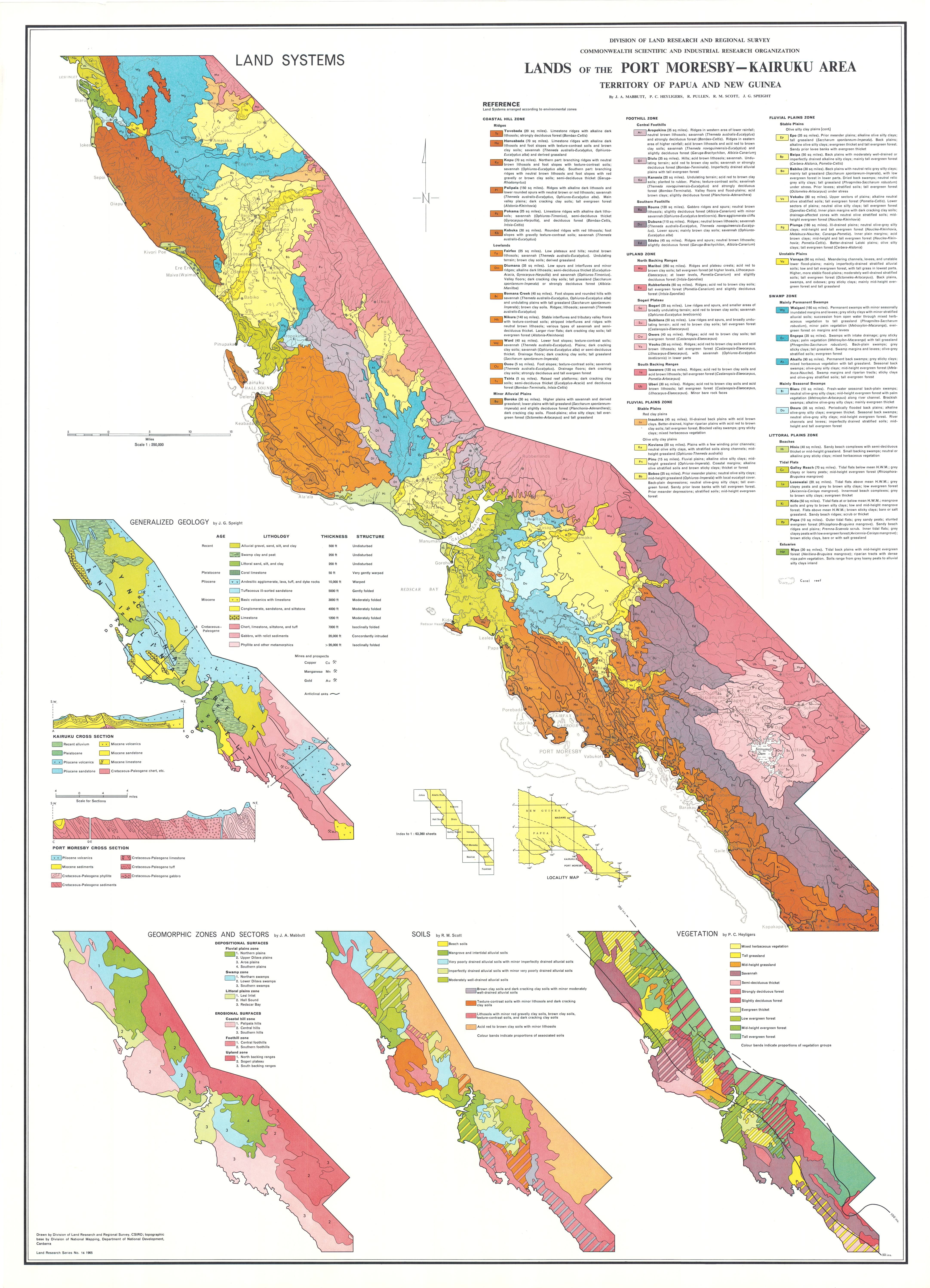
The Port Moresby–Kairuku survey covered approximately 7,125 km2 mainly of the Kairuku–Hiri and Rigo Districts of the Central Province of Papua with six major environmental zones parallel to the coast — Uplands, Foothills, Fluvial Plains, Swamps, Coastal Hills and Littoral Plains.
Like previous surveys, this area presented some difficulties. Changes in river courses and patterns of shifting cultivation meant that aerial photography coverage was out-of-date for some areas. Access was by jeep, motorcycle, boat and foot traverses, but road access for many traverses made site observations somewhat simpler.
The survey identified 233 land units in 49 land systems ranging from 13 km2 to 673 km2 with between two and nine land units each which are covered in the report. Tables show the diagnostic features of each land system in the framework of the major zones. The relative area, landform, vegetation, soil and land capability class is recorded for each land unit and their positions are shown on block diagrams.
Individual chapters describe:
- Climate — describes climatic controls, general characteristics and relations to plant growth and land use
- Geology — describes relationships between land systems and geology in terms of age, structure and lithology and notes on economic geology
- Geomorphology — describes land systems of the six major zones in terms of characteristic landforms and geomorphic processes
- Soils — describes 49 Soil Families in 13 soil groups and their distribution in the land systems
- Vegetation and Ecology — describes six major groups and 67 vegetation types and their distribution in the land systems of each major zone; and outlines ecological relations between vegetation and the area’s moisture regimes
- Land Classes — outlines present land use and describes land classes and their area, distribution and relations to soils and land use
Map 1 — Lands of the Port Moresby–Kairuku area, Territory of Papua and New Guinea by JA Mabbutt, PC Heyligers, R Pullen, RM Scott and JG Speight. One sheet: Land Systems. Scale 1:250,000. With insets: Generalized Geology by JG Speight; Geomorphic Zones and Sectors by JA Mabbutt; Soils by RM Scott; Vegetation by PC Heyligers. CSIRO Land Research Series No. 14, 1965.
Editor's Note: The area’s population of almost 71,000 in 1960 has grown to about 300,000 in 2011.
https://doi.org/10.1071/LRS14
© CSIRO 2010