

No. 17 Lands of the Safia–Pongani Area, Territory of Papua and New Guinea
Land Research Surveys
2010(1) 1 - 217
Published: 2010
Abstract
The Safia–Pongani survey covered an area of approximately 7,000 km2 mostly located in the Ijivitari District in Oro Province of Papua with altitude ranging from sea level to 3,350 m in six physiographic regions. The survey identified 45 land systems in eleven groups distinguished by the nature of their erosional surfaces, relief and altitude. The land systems range from 10 km2 to 518 km2 and have between three and nine units except for one with a single land unit.
The report provides a general description for the geology, geomorphology, soils, drainage status and vegetation of each land system. The relative area, landform, soil, vegetation and land capability class is recorded for land units and their positions are shown on block diagrams.
Individual chapters describe:
- Geology — describes six tectonic regions and arranges land systems according to rock groups and geological age
- Geomorphology — recognises six physical regions, describes regional drainage, geomorphic history and relationships between land systems and landforms
- Pedology — describes the classification, characteristics, distribution and area of 74 soil families in reference to land systems, details their distinguishing lithology, landform, vegetation and the range of selected chemical properties, and describes the formation and distribution of nine soil sequences
- Vegetation — outlines methods and a vegetation classification, describes 10 groups encompassing 39 vegetation types and shows relationships to land systems; also provides notes on special features of the vegetation and some individual tree species
- Forest Resources — outlines survey methods and 14 forest types and indicates ‘stocking rates’ and the frequency of occurrence of tree species in each type
- Agricultural Potential — outlines the land capability classification, shows areas of each sub-class across land systems, describes 12 land use capability groups and discusses aspects of climatic controls, population and communications
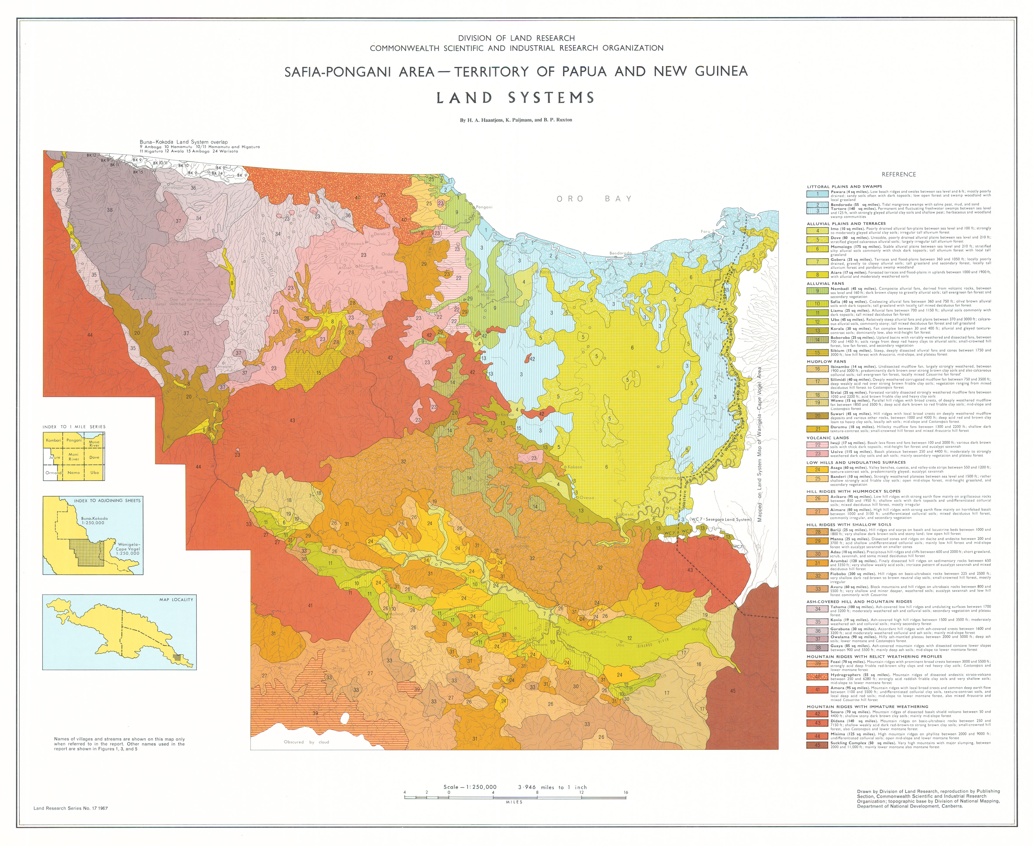
Map 1 — Safia–Pongoni area, Territory of Papua and New Guinea, Land Systems by HA Haantjens, K Paijmans and BP Ruxton. Scale 1:250,000. CSIRO Land Research Series No. 17, 1967.
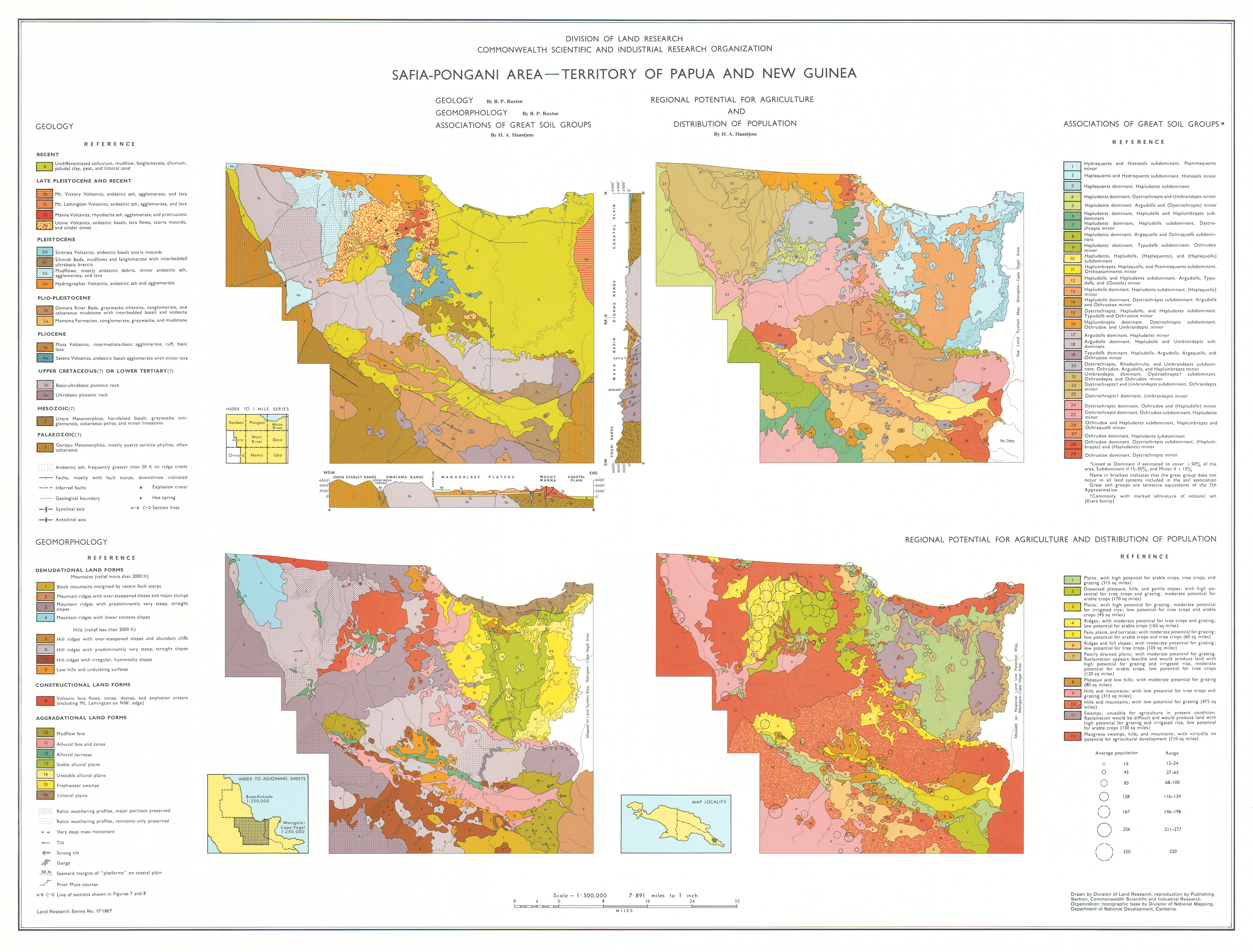
Map 2 — Safia–Pongoni area, Territory of Papua and New Guinea. Four maps on sheet, each scale 1:500,000: Geology by BP Ruxton; Geomorphology by BP Ruxton; Associations of Great Soil Groups by HA Haantjens; Regional Potential for Agriculture and Distribution of Population by HA Haantjens. CSIRO Land Research Series No. 17, 1967.
Map 3 — Safia–Pongoni area, Territory of Papua and New Guinea, Vegetation and Forest Resources by K Paijmans and JC Saunders. Scale 1:250,000. CSIRO Land Research Series No. 17, 1967.
Editor's Note: The population at the time of the survey was about 12,600 and by 2011 has approximately doubled.
https://doi.org/10.1071/LRS17
© CSIRO 2010