

No. 23 Lands of the Kerema–Vailala Area, Territory of Papua and New Guinea
Land Research Surveys
2010(1) 1 - 170
Published: 2010
Abstract
The Kerema–Vailala survey covered an area of ~ 8,475 km2, which is almost all of present day Kerema District and part of the Kikori District of Gulf Province and a small area in the vicinity of Aseki in Morobe Province, with altitude rangiing from sea level to 2,235 m.
The survey identified 29 land systems ranging from 29 km2 to 1,329 km2 in five characteristic environments. Each land system has with between two and eight land units. The report provides general descriptions for the geology, geomorphology, terrain parameters, population and land use and an agricultural capability assessment of each land system, with a thumbnail showing its location and extent. The area, landforms, vegetation, soils and physical and chemical limitations are recorded for 145 identified land units with their positions shown on block diagrams.
Individual disciplinary chapters describe:
- Climate — principal features and controls, rainfall and other characteristics and their relation to water balance and plant growth
- Geology — stratigraphy, chemical and mineralogical composition of sediments, and relation of geology to land systems
- Geomorphology — history and processes and geomorphology of land systems
- Pedology — soil classification and characteristics of 54 soil families in 26 groups, with selected physical properties and their distribution in relation to land systems
- Vegetation — methods and classification of seven major groups, with detail of included types, anthropogenic influences and ecological factors in the five environments
- Forest Resources — timber quality groups and details of 11 forest types and frequency of significant tree species in each type
- Population and Land Use — size, density, settlements and social groups and relationships of land use to environmental settings, with notes on land capability and cash crops
- Land Use Capability — assessments and maps of capability classes for arable crops, tree crops, improved pastures and irrigated rice
Map 1 — Land Systems of the Kerema–Vailala area, Territory of Papua and New Guinea by BP Ruxton, K Paijmans, P Bleeker and BJ Leach. Scale 1:250,000. CSIRO Land Research Series No. 23, 1969.
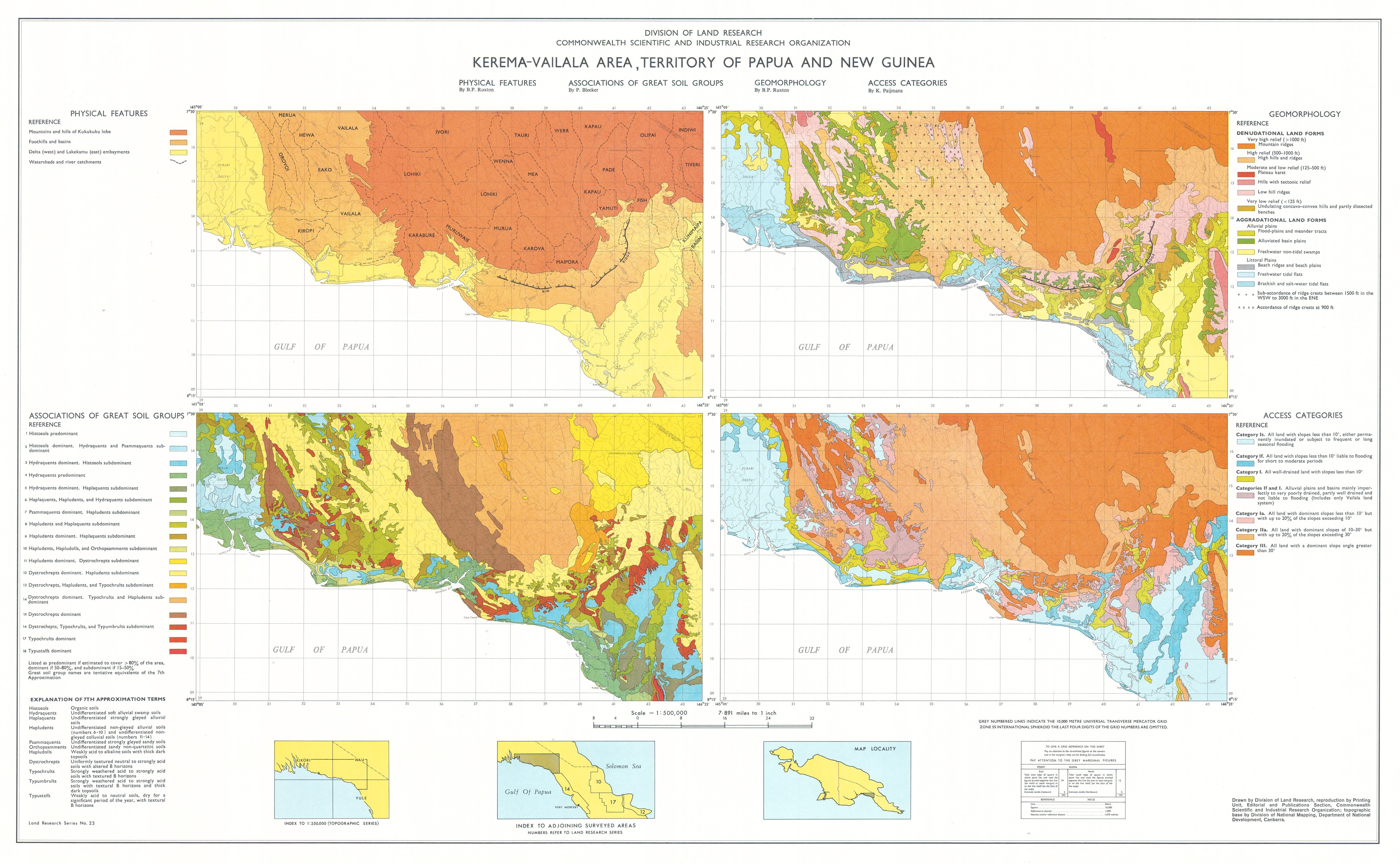
Map 2 — Physical Features, Associations of Great Soil Groups, Geomorphology and Access Categories of the Kerema–Vailala area, Territory of Papua and New Guinea. Four maps on sheet, scale each 1:500,000: Physical Features by BF Ruxton; Associations of Great Soil Groups by P Bleeker; Geomorphology by BP Ruxton; Access Categories by K Paijmans. CSIRO Land Research Series No 23, 1969.
Map 3 — Vegetation and Forest Resources of the Kerema–Vailala area, Territory of Papua and New Guinea by K Paijmans. Scale 1:250,000. CSIRO Land Research Series No. 23, 1969.
Editor's Note: The population of about 32,000 at the time of the survey exceeds 40,000 in 2011.
https://doi.org/10.1071/LRS23
© CSIRO 2010