Case studies of atmospheric rivers over China and Australia: new insight into their rainfall generation
Jingjing Chen A B , Huqiang Zhang C F , Chengzhi Ye B , Hongzhuan Chen D and Ruping Mo EA College of Meteorology and Oceanography, National University of Defense Technology, Nanjing, China.
B Hunan Meteorological Observatory, Changsha, China.
C Australian Bureau of Meteorology, GPO Box 1289k, Vic. 3001, Australia.
D Huaihua Meteorological Bureau, Huaihua, China.
E National Lab-West, Environment and Climate Change Canada, Vancouver, BC, Canada.
F Corresponding author. Email: Huqiang.Zhang@bom.gov.au
Journal of Southern Hemisphere Earth Systems Science 70(1) 17-35 https://doi.org/10.1071/ES19026
Submitted: 29 March 2019 Accepted: 11 September 2019 Published: 2 September 2020
Journal Compilation © BoM 2020 Open Access CC BY-NC-ND
Abstract
While the Australia–Asian (A-A) monsoon is a prominent feature of weather and climate in China and Australia, there are significant differences in their dominant weather patterns and climate drivers. In order to explore different characteristics of atmospheric rivers (ARs) affecting weather and climate in these two countries, this paper compares two typical AR events that occurred in the boreal summer (austral winter) in 2016. The event in China produced record-breaking rainfall in North China, whereas the event in Australia was accompanied by a classic Northwest Cloud Band (NWCB) and produced a rainfall belt across the continent. Using global reanalysis products and ground-based observational data, we analysed the synoptic backgrounds, vertical structures, water vapour sources and relationship between ARs and cloud distributions. In both China and Australia, heavy precipitation was triggered by strong water vapour transport by ARs ahead of midlatitude frontal systems. The main differences between these two AR events and their associated rainfall effectiveness were that (i) the AR intensity in the Asian summer monsoon was stronger than that in the austral winter season over Australia; (ii) the centre of AR maximum moisture transport in China was around 850 hPa, whereas in Australia, it was located at around 700 hPa; and (iii) the AR-induced rainfall was heavier in China than in Australia. These differences were caused by numerous factors, including a lack of topographic influence, a dry climate background in Australia, and different interactions between warm and moist air conveyed by ARs from the tropics with cold air from the midlatitudes. We paid particular attention to the relationship between the Australian AR and its associated cloud structure and rainfall to understand precipitation efficiency of the NWCB. In addition, we assessed the forecast skills of an Australian numerical weather prediction system (ACCESS-APS2) for the two events with different lead times. The model produced reasonable forecasts of the occurrence and intensity of both AR events several days in advance, and the AR forecast skill was better than its forecasts of rainfall location and intensity. This demonstrates the value of using AR analysis in guiding extreme rainfall forecasts with longer lead time.
Keywords: ACCESS-APS2, atmospheric river, cloud structures, extreme rainfall, monsoon, Northwest Cloud Band, numerical weather prediction, water vapour transport.
1 Introduction
Dominated by the East Asian monsoon that brings abundant warm and moist air from the tropics into the subtropics, the eastern part of China frequently experiences extreme rainfall and severe floods during its warm season. However, as there are many factors contributing to such extreme rainfall events, including the combined effect of West Pacific Subtropical High (WPSH), midlatitude blocking, low-level vortex and varying strengths of monsoon flows, extreme rainfall forecasting remains a significant challenge (Chen et al. 1991; Ding 2004; Wang 2006). Although numerical weather prediction (NWP) has made great progress in the past decade (Bauer et al. 2015), warm season heavy precipitation forecasts still cannot meet the social demand. For example, the extreme rainfall event that occurred in North China from 19 to 21 July 2016 caused over 30 fatalities and significant social and economic losses. For this event, the NWP forecasting system operated at the National Meteorological Center (NMC) of China showed poor skill in its short- and medium-term forecasts of rainfall location and intensity, and it underestimated the intensity of this event with a very short lead time (Wang et al. 2017). Therefore, improving our understanding of the underlying atmospheric dynamics and physics contributing to the extreme rainfall process in East Asia has been a key research area for many decades. As part of these efforts, recent studies used the atmospheric river (AR) concept to characterise detailed features of moisture transport within the Asian monsoon system and explore the connection between ARs and rainfall variations during the monsoon season (He et al. 2007; Gimeno et al. 2016; Yang et al. 2018). Assessing the current NWP system skill for forecasting ARs and the use of AR diagnosis to support and improve rainfall forecasts has become one of the areas of active research (Gimeno et al. 2014; Stan et al. 2017; Mo et al. 2019; Ralph et al. 2017, 2019).
Australia is an arid continent, with significant year-to-year rainfall fluctuations (Speer et al. 2011; Lavender and Abbs 2013). Its southwest and southeast parts are increasingly prone to drought. Recent studies, such as Cai and Cowan (2008) and Ummenhofer et al. (2008, 2011), linked rainfall variations in these regions with sea surface temperature (SST) conditions in tropical oceans. Yet, there is a lack of understanding of the role of moisture transport in the teleconnections between tropical SSTs in the Indian and Pacific oceans and the Australian rainfall variations. As reviewed by Ye et al. (2020) in this Research Front, Northwest Cloud Bands (NWCBs) are an important synoptic feature caused by tropical–extratropical interactions in Australia (Wright 1997), but there is a lack of understanding of the connections between NWCBs and their associated rainfall. Therefore, exploring moisture transport in the Australian region associated with ARs is of significant value for improving our understanding of the weather and climate in the region.
As discussed in Ye et al. (2020), an AR can be generally defined as a long, narrow and transient corridor of strong water vapour transport in the lower atmosphere, usually originating from tropical oceans and closely associated with a low-level jet ahead of the cold front of an extratropical cyclone (American Meteorological Society 2019). ARs are responsible for most (>90%) of the atmospheric water vapour transport in the midlatitudes (Newell et al. 1992; Zhu and Newell 1994, 1998), and their close relationships with heavy precipitation events have been demonstrated in many studies (e.g. Ralph et al. 2004, 2019; Bao et al. 2006; Neiman et al. 2008a, 2008b; Lavers et al. 2012; Gimeno et al. 2014; Jiang et al. 2014; Mahoney et al. 2016; Stan et al. 2017; Mo and Lin 2019; Mo et al. 2019). It has been shown that the primary characteristic of an AR is its high water vapour content in the lower atmosphere, which can cause heavy precipitation and trigger severe natural disasters, such as floods, mudslides and avalanches, when it makes its landing and meets with coastal mountain uplift (Ralph et al. 2006). Therefore, AR forecasting can play an important role in producing early warning of heavy rainfall events.
As pointed out by Ye et al. (2020), a large body of AR research is focused on North America and Europe (Ralph et al. 2004, 2013, 2017; Neiman et al. 2008a, 2008b; Dettinger et al. 2011; Lavers et al. 2011; Lavers and Villarini 2013, 2015; Mahoney et al. 2016; Browning 2018; Viale et al. 2018; Zhang et al. 2019). The established AR conceptual model is most applicable to the heavy precipitation events caused by landfalling ARs along the mountainous west coast of North America, where the AR-induced warm, moist airflows can be orthogonally blocked and forced to lift by coastal mountains (Gimeno et al. 2014; American Meteorological Society 2019). However, given that there are different orographic features and climatic backgrounds, how ARs affect East Asian and Australian weather and climate may be different to the conceptual model developed in North America.
It is generally believed that water vapour affecting precipitation in East Asia mainly comes from the tropical Indian Ocean, the Western Pacific Ocean and the South China Sea (e.g. Huang et al. 1998; Simmonds et al. 1999; Ding 2004; Zhang 2010). Note that the presence of the Tibetan Plateau acts mainly to channel the moisture around the terrain, rather than to orthogonally block the moist flows from penetrating into the interior of East Asia. Therefore, although several recent studies have detected ARs in the East Asian monsoon region (Zhu and Newell 1998; Wick et al. 2013; Wick 2014; Guan and Waliser 2015; Yang et al. 2018), it is unclear if the mechanisms associated with the North American west coast landfalling ARs remain valid in the East Asian monsoon climate, and many unanswered questions remain, such as what are the unique characteristics of ARs affecting East Asia? Does topography also play a key role in the generation of heavy precipitation caused by ARs? Can ARs also bring heavy precipitation to the monsoon region during the cool season?
Furthermore, although both weather and climate in China and Australia are influenced by monsoons that result from tropical–extratropical interactions, it is unclear if the ARs in the Asian monsoon region have different characteristics from those operating in the Australian monsoon region. Note that the East Asian summer monsoon region is characterised by a wet climate and influenced by complex terrains, whereas the Australian climate is dominated by a weak monsoon in its north and a dry, arid climate in a large part of the continent with relatively weak orographic forcing. Therefore, comparing ARs in these two regions can help to consolidate our understanding of ARs operating in the Australia–Asian (A–A) region. As part of the activities under the collaborative project between the Australian Bureau of Meteorology (BoM) and the China Meteorological Administration (CMA) (Ye et al. 2020), in this study we have not only analysed the extremely heavy rain event that occurred in North China during 18–21 July 2016, but also a large-scale rain event that occurred in Australia during 28–30 August 2016. During the later event, a classic long and narrow NWCB occurred and produced a rainfall belt across the continent from the northwest to southeast. Our study focuses on comparing these events to assess differences in their AR structural characteristics, water vapour sources, and relationship between ARs, cloud profiles and heavy precipitation. We further demonstrate the value of AR diagnosis in supporting rainfall forecasts with longer lead times.
In Section 2 we introduce the analytical method and dataset used in our analysis. Cumulative rainfall distributions, synoptic patterns, AR vertical characteristics, AR water vapour sources and budgets of the two AR events in China and Australia are analysed in Section 3. Furthermore, we pay particular attention to the relationship between the AR and NWCB in the Australian event. In Section 4, we assess the forecast skills from the BoM global NWP system, known as ACCESS-APS2, for the two events with different lead times. We compare the model’s skill in forecasting ARs and rainfall to demonstrate the potential benefit of using AR diagnosis to improve rainfall forecasts with longer lead times. Finally, Section 5 summarises the main conclusions from our study and highlights some possible follow-on research.
2 Data and methods
In this study, we have used the AR database developed by the bilateral BOM–CMA project, as described in Wu et al. (2020) and Ye et al. (2020), in which the Japanese Re-Analysis of 55 years (JRA-55) data at 1.25° × 1.25° horizontal resolution was used to detect ARs. NCEP Climate Forecast System Version 2 reanalysis data (Saha et al. 2014) was used to explore atmospheric circulation and moisture transport associated with the AR events in China (18–21 July 2016) and Australia (28–30 August 2016). Note that for the AR analysis results were very similar when using either JRA-55 or NCEP data. To study the AR-rainfall connections, more than 2400 station rainfall records of mainland China were collected by the CMA (available at http://data.cma.cn) from 18 to 21 July 2016. The gridded Australian Water Availability Project daily rainfall dataset at 0.25° × 0.25° resolution (Jones et al. 2009) were used for the Australian event. As previously mentioned, one important component of our AR study was to assess the skill of current NWP models in forecasting ARs. Therefore, we assessed NWP operational forecasts from the BoM ACCESS-APS2 global model (http://www.bom.gov.au/australia/charts/bulletins/APOB105.pdf) for the two AR events. This was the operational system available when our analysis was conducted, but it has been recently upgraded to ACCESS-APS3. Detailed information on the ACCESS system can be found in the webpage above (BNOC 2016). The ACCESS-APS2 global model resolution is 25 km, and in this study, we have only evaluated its forecasts from a 0000 UTC start time.
The definition and detection of ARs in this study are the same as those introduced by Ye et al. (2020) and used by other studies in the BoM–CMA project. ARs are defined as vertically Integrated Vapour Transport (IVT):

where g is gravitational acceleration, q is specific humidity, V is horizontal wind vector, p is atmospheric pressure, and psfc and ptop are atmospheric pressure values at the surface and top of the atmosphere, respectively. In practical application, IVT is generally integrated to 300 hPa (close to the tropopause). As shown in detail in Section 3, the two cases that we analysed in China and Australia met with the AR thresholds of Guan and Waliser (2015): a long and narrow corridor of strong IVT, bound by the positions of IVT = 250 kg m−1 s−1, a minimum length ≥2000 km and a length/width ratio ≥2.
3 AR events in China and Australia
3.1 Synoptic background
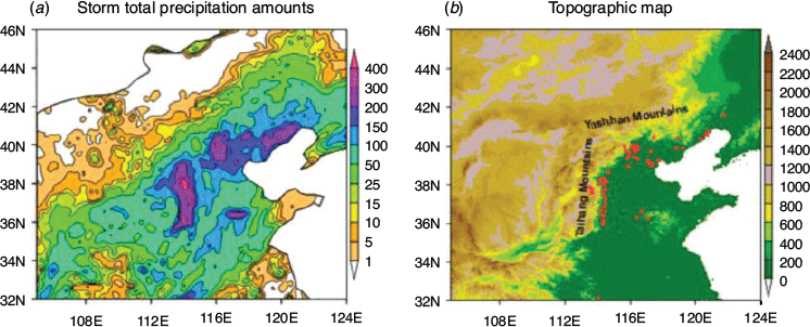
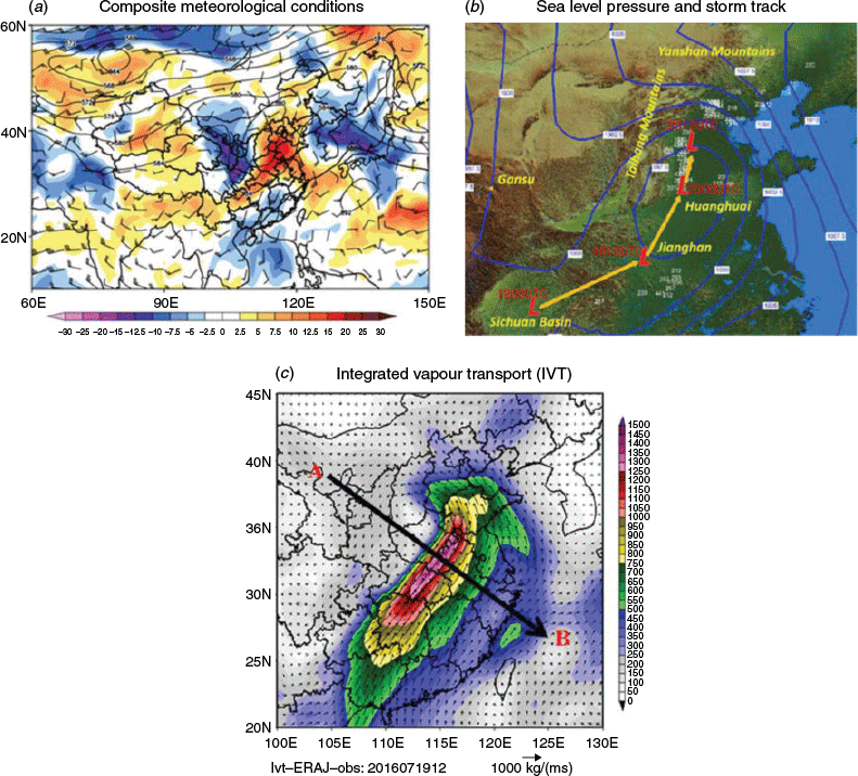
As shown in Fig. 1a, which was produced by using the CMA operational visualisation tool with 2400 station data, the North China heavy rainfall event occurred from 18 to 21 July 2016 (known as the ‘July 16’ event in China). It was characterised by large accumulated precipitation, long duration and extreme rainfall intensity. Accumulated rainfall in several regions in Central and North China reached 700–880 mm, and the heavy rainstorm that occurred during this event covered an area of 369 000 km2, which was more than one third of the country. Daily rainfall in 22 cities exceeded their historical records, and 53 weather stations received record-breaking rainfall in July (Wang et al. 2017). Another notable feature was that heavy rainfall tended to distribute along the terrains, with most of the heavy rainfall centres located along the east side of Taihang Mountains and the south side of Yanshan Mountains (Fig. 1b). For the heavy rainfall on the eastern side of the Taihang Mountains, we show that these locations are in parallel with the direction of the AR affecting this region (Fig. 2b, c). This is different from the conceptual model proposed in North America for understanding the mechanism of AR-induced extreme rainfall in its west coast mountain regions. Therefore, we devoted detailed analysis on understanding this rainfall event in China.
This rainfall event was directly influenced by a mesoscale system embedded within a favourable large-scale circulation background (Fu et al. 2017). At its early development stage in the middle of July, the ridge line of the WPSH was located around 20°N, and a trough developed over the Tibetan Plateau, which moved out eastward via the eastern part of the Gansu province on 18 July 2016 (Fig. 2a). Meanwhile, a southwest vortex over the Sichuan Basin moved north-eastward into the Jianghan Plain (Fig. 2b). After that, the ridge line of WPSH jumped noticeably northward, reaching around 30oN (Quan and He 2016). On 19 July, the trough from the Tibetan Plateau and the vortex from the Sichuan Basin met in an area south of Taihang Mountains in Central China, forming a deep cut-off low in North China, with a central air pressure of 992.7 hPa and a 500 hPa potential height below 580 geopotential decameters (gpdm) (Fig. 2a, b). Subsequently, this cut-off low continued to move northeast, affecting North China, Huang Huai, Jianghan and regions south of Northeast China. While the WPSH extended northward, it met with the ridge of another high-pressure system at mid-latitudes and formed a high-pressure belt. This high-pressure belt also acted to significantly slow down the movement of the cut-off low to produce steady rainfall over the region along the Taihang Mountains. The low system eventually moved out of North China on 21 July, which ended this extreme rainfall event.
|
This event was not only characterised by the deep cut-off low and its slow movement into the North China region but also an intensive, warm and moist airflow, which penetrated the region from the south. During this event, a low-level jet, with a core wind speed exceeding 24 ms−1, formed from the southwest to northeast in the Central-East China region. A strong water vapour transport associated with it, which can be classified as an AR using the threshold of Guan and Waliser (2015), formed between the western flank of the WPSH and the edge of the Tibetan Plateau (Fig. 2c). It carried warm and humid air from the tropics into the North China plain, feeding into the cut-off low dynamic system, and contributed significantly to the heavy rainfall over the region. The volumetric atmospheric precipitable water (PW) on the south and east sides of the surface cyclone was significantly higher than its annual averaged for the same period, showing a long and narrow belt of positive anomalies corresponding to the position of the AR (Fig. 2a). Note that the cut-off low dominating the region moved from the southwest to the northeast during this event (Fig. 2b). Thus, the easterly flow in the northern part of the cut-off low met orthogonally with the Taihang mountain terrain on its west at the early part of the event, while its southerly flow was confronted by the Yanshan mountain terrain when the cut-off low moved to the north. Both resulted in strong low-level convergence, orographically induced dynamical uplift and convection development on the windward slope of the terrains, and led to heavy rainstorms along the eastern side of the Taihang Mountains and southern side of the Yanshan Mountains, as seen in Fig. 1a and b.
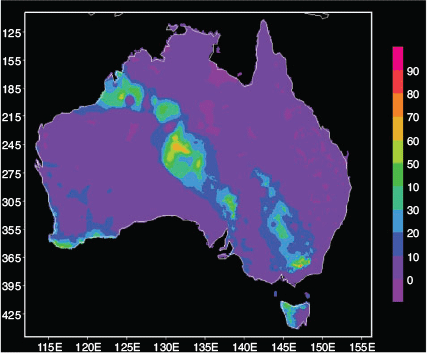
In Australia, during 28–30 August 2016, a large-scale rainfall event occurred from northwest Western Australia to southeast South Australia (Fig. 3). On 29 August, daily precipitation at the Marree Weather Station in South Australia reached 49.8 mm, which is high and extreme for this area (the average annual total precipitation is only about 320 mm). Although the rainfall amount is much less than the rainfall event in China, it is still a notable event given its rainfall spatial coverage and the amount received relative to its low mean climatology.
|
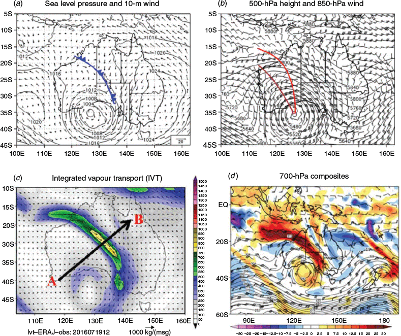
This rainfall event in Australia was also a product of the interactions between a midlatitude cyclonic system with tropical/subtropical synoptics. On 26 August 2016, a deep midlatitude trough occurred over the southern Indian Ocean southwest of Australia. Then the deep trough moved slowly eastward towards the southwest of Australia, reaching its strongest at 0000 UTC on the 27 August (not shown), with a cut-off low, which is influential on the Australian weather and climate (Qi et al. 1999), dominating that region with a central pressure of 992 hPa. From then, the intensity of the system started weakening. On 29 August, the centre of the low moved to 127°E and 35°S, with the central air pressure reaching 1000 hPa (Fig. 4a). This cut-off low system was deep and its closed low centre extended from the ground to the upper troposphere (not shown). To the northeast of the low centre was a cold front stretching northwest to southeast (Fig. 4a and b), with northerly or north-easterly winds ahead of the front and northerly winds behind the front. The low-level air temperature gradient of the cold front reached 6°C. At 500 hPa, a deep trough extended northwest from the centre of the cold vortex (Fig. 4b). Associated with the synoptic pattern, a low-level jet formed at 850 hPa, with a north-westerly wind speed up to 15 ms−1. Along the axis of the low-level jet, a wet tongue with relative humidity greater than 80% moved inland from the eastern side of the Indian Ocean and off the Sumatra–Java region. From the 700 hPa synoptic chart on 29 August, combined with the atmospheric PW anomaly (Fig. 4d), one can see that there is an area of very high water vapour content along the jet stream of the cut-off low. Using the same AR detection threshold of calculated IVT from Guan and Waliser (2015), this region of abnormally high atmospheric moisture volume can be classified as an AR event. The vertically integrated water vapour transport (Fig. 4c) clearly shows the transport of water vapour from the tropical Indian Ocean into the continent, where it contributed to the large-scale rainfall event across the interior region. In the following section, further backward trajectory analysis demonstrates the contribution of this AR in transporting the tropically originated air mass into the continent, which led to the formation of the high moisture band and associated rainfall.
|
3.2 Characteristics of the two ARs
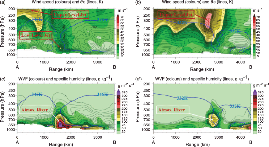
Most AR studies have focused on documenting the spatial and temporal distributions of ARs in various regions, with only a few studies, such as Ralph et al. (2004) and Gimeno et al. (2014, 2016), reporting the vertical structure of ARs based on observations in North America. They showed the importance of the AR vertical structure in understanding its influence on extreme rainfall generation. Here, we compare the vertical profiles of wind speed, equivalent potential temperature (θe), atmospheric water vapour flux (WVF) and specific humidity along a vertical cross-section passing through the centre of the ARs for both cases (shown as arrows A–B in Fig. 2c and Fig. 4c).
For the case in China (Fig. 5a and c), the centres of the AR, water vapour convergence and low-level jet core are all close to 850 hPa and almost coincide with each other. Furthermore, the core of the low-level jet is located ahead of the cold frontal system, which is represented by a large gradient of θe (with very dense isothermal lines) in Fig. 5a. At the same time, this AR is confined by a very stable WPSH to its right, with a large, positive vertical gradient of θe. This AR brings strong, moist and warm air from the tropics into the region, which is demonstrated by very high values of atmospheric humidity and θe. Moisture carried by this AR fed into the deep cut-off low located in North China, which further transported water vapour northward towards the Yanshan Mountains and westward towards the Taihang Mountains. In the next section, backward trajectory analysis shows the AR contribution to extreme rainfall in the region.
|
As shown in Fig. 5b and d, the vertical structure of AR for the Australian case is quite different to China. For the Australian case, there was not a significant low-level jet close to the location where the AR occurred, but there was a strong upper jet stream instead. The maximum water vapour transport associated with the AR is close to 700 hPa, which is higher than the typical location (~850 hPa) seen in the ARs in China or North America (Gimeno et al. 2014). The intensity of the AR is also weaker than that in China. Nevertheless, there are some common features of these two AR vertical structures. As shown in Fig. 5a and b, both ARs are confined between a midlatitude cold front and a subtropical high, suggesting the AR formation in the A–A monsoon region is the product of tropical–extratropical interactions. Indeed, many studies of the NWCB in Australia pointed out that these long and narrow cloud bands are the product of such interactions (e.g. Wright 1997).
3.3 Water vapour source and budget analyses
One scientific debate on the concept and application of ARs is about their moisture source. One can identify elongated and filamentary structures from satellite cloud images or from satellite moisture channels that look like ARs, but it is unclear whether these cloud images indeed reflect moisture transport from the tropics into the extratropics or whether these images merely reflect the dynamical effect of midlatitude cyclonic systems, which uplift local atmospheric moisture into the condensation level to form river-like clouds. It is also unclear if high moisture content in the ARs is actually transported remotely from tropical/subtropical oceans or from a local source. A study by Bao et al. (2006) showed moisture sources associated with ARs that landed in North America had two origins: one was a local moisture convergence along the front of extratropical cyclones, and the other was direct poleward transport of tropical moisture by ARs. A recent study by Eiras-Barca et al. (2016) analysed moisture sources for ARs in the North Atlantic Ocean basin and found important contributions from the subtropical and tropical North Atlantic. They emphasised anomalous advection of moisture through ARs, together with midlatitude anomalous sources closer to AR landfalls. However, another recent study by Dacre et al. (2015) analysed high PW bands associated with extratropical cyclones in the North Atlantic sector and argued that a large part of the moisture source for these ARs was from local moisture sources and large-scale moisture convergence, rather than an advected source from the tropics. In addition, the moisture source associated with the NWCB in the Australian region (e.g. Frederiksen and Balgovind 1994; Wright 1997; Ye et al. 2020) is also an area under intensive debate that needs further detailed investigation. Therefore, in our case studies, we conduct further analysis to explore the moisture sources for the two ARs, particularly considering that these two ARs operated in the inland regions in the East Asia and Australian continent where local water vapour source through continental evapotranspiration is weak (van der Ent et al. 2010).
In this part of the analysis, the backward trajectory model, HYSPLIT 4, developed by the Air Resources Laboratory of NOAA (Draxler and Hess 1998) is used to examine pathways of the air masses that formed the ARs and contributed to their rainfall generation. The domains used to conduct such backward tracking are over the areas where heavy rainfall occurred during these two cases; this is over 35–40°N, 113–118°E in China and over 22–27°S, 130–135°E in Australia. The trajectory analysis started at 6 × 6 grid points uniformly distributed across the selected domains and performed at three initial heights of 500, 1500 and 3000 m. Five-day backward trajectories were simulated from five selected start times (0000, 0600, 1200 and 1800 UTC of 19 July 2016 and 0000 UTC of 20 July 2016) for the case in China, when peak rainfall occurred. For the Australian case, the selected start times were 0000, 0600, 1200 and 1800 UTC of 29 August and 0000 UTC 30 August. Therefore, for each case, there were 540 trajectories corresponding to 36 starting points at three levels and at five start times. Due to the large number of trajectories from such simulations, cluster analysis was carried out by merging these trajectories into a limited number of major pathways. Each pathway was taken as the averaged trajectories for the corresponding cluster identified (Stunder 1996).
To analyse the water vapour contributions of different pathways, the following formula was used to calculate the water vapour flux contribution rate:

where Qa is the contribution rate of each pathway, Qi and Qj are the water vapour flux at each trajectory that belongs to that pathway, m indicates the number of trajectories contained in the pathway/cluster, and n is the total number of trajectories.
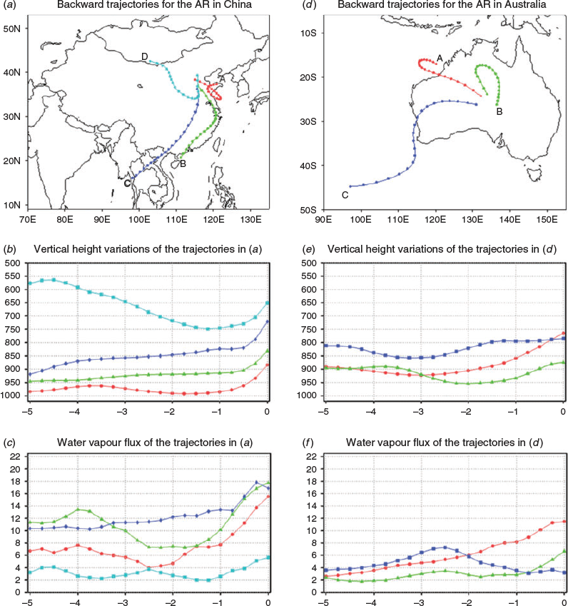
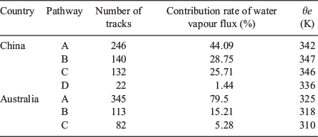
From the cluster analysis, we saw four main pathways/channels of air mass being transported into the area of high rainfall for the China case (Fig. 6a). The first one appeared to be from the Yellow Sea area (pathway A) where air was carried from the Yellow Sea and nearby area by a south-easterly flow into the rainstorm area. The second one is the South China Sea channel (pathway B), which carried an air mass from the South China Sea to the rainstorm area via Eastern China. The third one is from the Bay of Bengal (pathway C), which carried an air mass through south-westerly monsoon flow from the Indian Ocean and Bay of Bengal into the rainstorm area via the Indochina Peninsula. The fourth one is the northwest channel (pathway D), which carried an air mass through north-westerly flow from the West Siberian region into the rainstorm area.
Nevertheless, the importance of these pathways in contributing to the North China extreme rainfall event relies on the thermodynamic properties of the air mass carried over by these pathways. Therefore, we examined these pathways in detail, including their height (Fig. 6b together with Table 1), the water vapour flux they carried (Fig. 6c) and their θe, which measures how warm and moist the air mass is when leading to atmospheric convection and rainfall generation. Clearly, the air mass generated from the northwest (pathway D) was cold and dry and mainly occurred around 700 hPa and above. This reflects the penetration of a cold air mass from the midlatitudes, not an effective moisture source. Although it formed an important dynamic process for rainfall generation. it contributed to less than 2% of total water flux. The main moisture source for the event came from pathway A, B and C, i.e. a local source (pathway A) and two remote tropical, warm ocean sources. All of them have high θe values (Table 1). Fig. 6b further shows that these channels are mainly located in the low troposphere below 850 hPa where the air mass was only uplifted close to the time of rainfall occurrence, either by orographic dynamical uplift when confronted by the Taihang and Yanshan mountains, or by the downward penetration of dry and cold air from pathway D shown in Fig. 6b. These pathways appear to be consistent with previous studies that suggest water vapour channels affect precipitation in Central and Eastern China (Tao and Chen 1987; Chen et al. 1991; Chang 2004; Wang 2006).
|
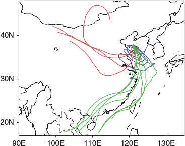
Without detailed analysis, one may think that the most important moisture supply for this rainfall event came from pathway A. The number of trajectories clustered around this path is the largest of the four (Table 1), and the contribution to the overall water vapour flux into that rainfall region reaches 44%, which is also the largest. However, there is a legitimate question concerning these results: where did the moisture carried over by pathway A into the rainfall region come from in the first place? The SSTs in the Yellow Sea region, where the air mass in pathway A appears to originate from, are much cooler than the SSTs in the tropical oceans, which are the origin of pathway C (the Bay of Bengal) and pathway B (the South China Sea region). Thus, we expect that the moisture source for supporting pathway A is much weaker than that for pathways B and C. Another feature is that pathway A operated in a very limited area and curved around for the five-day tracking period, so it appeared to be transporting atmospheric moisture accumulated in this region. On top of that, the time evolution of water vapour flux in Fig. 6c shows that the contribution from pathway A only started to become significant about a day ahead of the occurrence of the extreme rainfall. In contrast, the orientation and location of pathways B and C resemble the direction of the AR detected for this case (ref. Fig. 2c). Furthermore, pathways B and C consistently provided warm and moist air (with θe being about 4–5oC higher than pathway A) throughout the rainfall event. All these features prompt us to think that the moisture carried by pathway A may have actually come from the AR in the southwest. Therefore, we conducted another set of backward trajectory simulations to understand the moisture source over the region where the backward tracking of pathway A ended. Fig. 7 shows the five-day backward trajectory simulations for the location at 38°N and 121°E in the centre of the area where pathway A originated. There are 15 trajectories, starting from this single location (repeated at three levels of 500, 1500 and 3000 m height and five times: 0000, 0600, 1200, 1800 UTC of 19 July 2016 and 0000 UTC of 20 July 2016). The colours show the corresponding θe values of these tracks. There are several features contained in this figure. Firstly, one can clearly see that the majority of the tracks come from the southwest and they are very similar to the pathways B and C. Secondly, the tracks from the southwest are much warmer and moister, with much higher θe values than the other trajectories. All these characteristics demonstrate that atmospheric moisture accumulated in this area and was further transported into the precipitation region by pathway A, which actually originated from the tropics and was transported into the Yellow Sea area by the AR shown in Fig. 2c.
|
Backward trajectory analysis revealed some different features of possible moisture sources for the AR event in Australia. We selected 22–27°S, 130–135°E as the starting area for backward tracking simulation for two reasons. Firstly, this area received relatively high rainfall during the high-rainfall event, with a maximum precipitation of 49.8 mm compared with its annual total of 320 mm. Secondly, Australia is a large, dry continent with very limited local moisture sources in its interior region. In the study of NCWB, there is always a question about whether tropical originated moisture can be transported over such a long distance to support cloud band formation and rainfall generation in Australia’s central region. Therefore, choosing such an interior area to analyse can help us to answer these questions. Similar to the trajectory simulations in China, we conducted five-day backward trajectory simulations, with a total of 540 trajectories generated over 36 grid points at three vertical levels and five start times. Through cluster analysis, three main air mass pathways were identified (Fig. 6d). Of them, pathway A represents an air mass coming from the northwest, mainly located over warm water in the eastern part of the tropical Indian Ocean and off the Sumatra–Java coast. This pathway has the largest number of tracks simulated for the period and it contributed 80% of the total water vapour flux into this region. Results in Table 1 also suggest that pathway A is warmer and wetter than the other two pathways, of which pathway B represents air from a local source and pathway C is associated with a midlatitude trough and cyclonic airflow, as illustrated in Fig. 4a and b. Both pathway B and C are dry, and pathway C is also cold. The θe in pathway C is 15°C lower than that of pathway A. The orientation of pathway A is very close to the AR direction detected in this event (Fig. 4c). All these results suggest that the air mass source from northwest of the tropical Indian Ocean was the most important moisture source for supporting the rainfall generation in this event. The AR played a significant role in transporting the tropical warm and wet air mass into the continent and contributed to the formation of NCWB and its rainfall generation. Furthermore, compared with the results in China, the thermodynamic property of trajectories in the Australian AR case were less favourable for atmospheric convection development and rainfall generation. The water flux carried by these tracks (Fig. 6f) was much lower than that in China, and the θe is about 20°C lower. This explains why the rainfall efficiency associated with this AR/NWCB was much weaker than that in China.
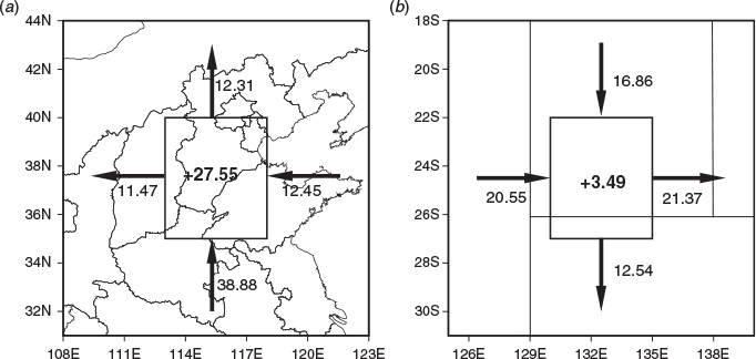
Following the trajectory analysis, we further analysed the regional water vapour budget to quantify the water vapour transport and moisture budgets for these two cases. The regions used in the water budget analysis were the same as the regions selected for backward trajectory simulation. Fig. 8 shows the water vapour inflow/outflow at each boundary for the two events. At each boundary, the water vapour inflow/outflow was calculated as:

where ps is surface pressure, pt is 100 hPa, λ is the latitude and longitude range of the calculation area, V is the u wind or v wind and F is the water vapour flux at the boundary. We further decomposed the water vapour budget as follows:

|
where σ is the area of selected, pb is the surface pressure and pt is the pressure of the top boundary, which is 100 hPa in this analysis. The first term in the square brackets on the left side of Eqn 4 is the local moisture variations, the second term is water vapour horizontal divergence, and the third term is moisture vertical transport. On the right of this equation, m is the water vapour condensation term (or precipitation term) and Es is the evaporation term. Only the left terms in the regional water vapour budget equation (Eqn 4) are calculated in this analysis, where negative values indicate the convergence of water vapour and positive values indicate the divergence.
Fig. 8 clearly shows that during the ‘July 16’ rainfall event in China, the south and east boundaries of the rainstorm region are the main water vapour inflow boundaries, especially the south boundary, which accounts for more than 3/4 of the total water vapour input fed into the rainfall system, highlighting the importance of moisture transported into the region via the AR from the south. For the analysis of the Australian case, the western and northern boundaries are the main water vapour inflow boundaries, while the eastern and southern boundaries have significant outflows. Again, the large inflow from the north and west boundaries contributed to the AR, which transported warm and wet water vapour from the tropical eastern Indian Ocean. Although there were net water vapour gains in the rainfall regions in both events, it was much higher in the China case (27.55 × 10⁷ kg s−1) than the Australian one (3.49 × 10⁷ kg s−1). As a result, the maximum 24-h rainfall in the China event (380.0 mm) was also much higher than in the Australian event (maximum grid rainfall of 69.4 mm). Another feature in Fig. 8 is that the total inflow from the north and west boundaries by the AR in Australia (~37 × 107 kg s−1) (Fig. 8b) is close to the inflow on the south boundary of the China case in Fig. 8a (~39 × 107 kg s−1), but there is a lack of blocking of such warm and moist air when the northwest–southeast AR penetrated into the Australian continent. Much of its water vapour was lost through strong outflows. In contrast, for the case in China, the Yanshan Mountains in the north, the deep cut-off low at the end of the AR pathway and a persistent ridge in Northeast China all played an important role in the generation of strong moisture convergence in the rainstorm region, which produced heavy rainfall.
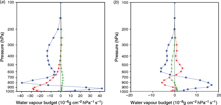
Fig. 9 shows the vertical profiles of the water vapour budget averaged over the two areas shown in Fig. 8. There are some common features for the two cases: (i) strong moisture convergence in the low troposphere from the surface up to 600 hPa, with a maximum at ~900 hPa for the case in China. The magnitude of low-level moisture convergence is much weaker and shallower in the Australian case, with a strong divergence in the middle of the troposphere (around 500 hPa); (ii) there is a strong uplift and transport of water vapour in the low-levels of the troposphere, with the feature being more evident in the boundary layer for the case in China, whereas it is weaker and extends deeper in the Australian case. For both cases, there is a strong vertical accumulation (i.e. vertical convergence) of the moist air from the low levels, contributing to the formation of clouds and rainfall. Both cases suggest that water vapour is concentrated in the lower levels through horizontal convergence and then transported to the middle and upper troposphere by upward movement.
|
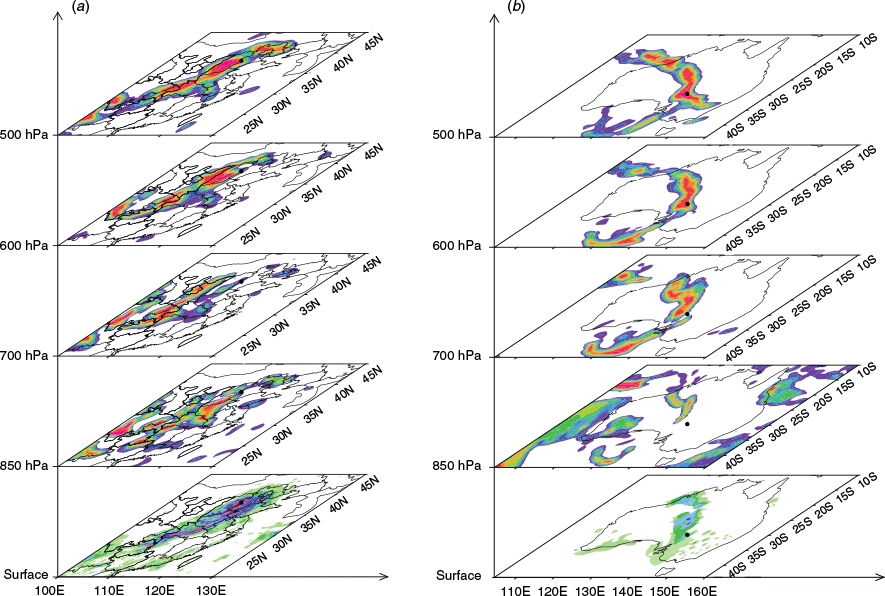
As discussed in the introduction section, and in Ye et al. (2020), one of the focuses of this BoM–CMA collaborative research is to use AR diagnosis to better understand the complex relationship between NWCB and ARs operating in the Australian region. Therefore, we have examined the cloud structures associated with the AR case in Australia and compared these with the results in China. As shown in Ye et al. (2020), the Australian case had a northwest–southeast cloud belt corresponding to a belt of high PW content across the Australian continent during the peak of this event. Because of the lack of observed cloud data at different levels, we used ERA-Interim cloud data to show the cloud distributions at 500, 600, 700 and 850 hPa levels (Fig. 10). The results show that in the case in China, each layer of cloud does not show a band-like distribution similar to AR, but each layer of cloud has a good correspondence with the location of heavy rainfall on the ground. This suggests that rainfall generated in the AR case in China is more associated with the development of deep convections, which developed from the low boundary and extend to the middle and upper troposphere. In contrast, clouds at 700, 600 and 500 hPa levels for the Australian case show clear band-like distributions, and the rainfall distribution corresponded well to the cloud bands above 700 hPa. The positions of these cloud bands at different levels align well with the positions of the cold front and middle and upper level deep trough dominating the western part of the continent (ref. Fig. 4a and b). Therefore, this cloud band was dynamically produced by the midlatitude frontal system interacting with a subtropical ridge dominating the northern and eastern part of the continent. These narrow and elongated band structures reflect the interactions between cold air from the midlatitudes and the warm air from the subtropics (Wright 1997). However, the moisture transport by the AR played a significant role in the formation of the cloud band and its rainfall generation. Wu et al. (2020), in this Research Front, have demonstrated the importance of moisture transport by the ARs in contributing to the rainfall generation of NWCBs. Our moisture trajectory and water budget analyses, together with the cloud analysis, suggest that NWCB shape is defined by the frontal system colliding with a subtropical ridge, but the cloud thickness, the level of its occurrence and its rainfall efficiency are largely impacted by the moisture transport from the tropics into the band. Results from Wu et al. (2020) further showed that if there is an AR operating underneath the cloud band, the possibility of rainfall band occurrence increases.
4 NWP forecast skill analysis
As pointed out by Ye et al. (2020), the collaborative study of ARs in the A–A region has two purposes: one is to use the AR concept to explore detailed characteristics of atmospheric moisture transport in the A–A region; the other is to assess the predictability of ARs by NWP and coupled seasonal forecasting models. Whereas Liang et al. (2020), in this Research Front, reported the performance of the seasonal forecasting model of the BoM in forecasting moisture transport at intraseasonal and seasonal time scales, here we evaluate the skill of the Australian NWP global model ACCESS-APS2 (BNOC 2016) in forecasting daily precipitation and ARs for both cases in China and Australia, as described in Section 3. APS2 was the operational system used when the analysis was conducted, and recently it has been upgraded to APS3. We are in the process of further assessing APS3 AR forecast skills and will report such results in a future study. Detailed information on the APS2 system is publicly available at http://www.bom.gov.au/australia/charts/bulletins/APOB105.pdf. Note that after the historical ‘July 16’ rainfall event in China, several studies (e.g. Wang et al. 2017) have assessed the performance of operational NWP forecast systems, including the system by the CMA. They found that current NWP systems, including the ECMWF (European Centre for Medium-Range Weather Forecasts) forecasts, had significant errors in forecasting heavy rainfall locations and the intensity of this event.
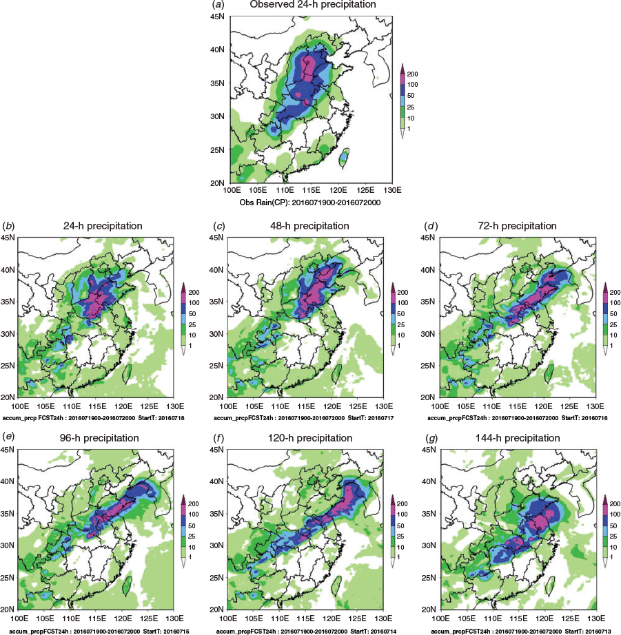
Fig. 11a shows the intensity and location of the heaviest rainfall for the China case, which occurred from 0000 UTC 19 July to 0000 UTC 20 July 2016. Clearly ACCESS-APS2 global model is skilful in predicting a heavy rainfall event occurring north of 30°N in North China and its nearby region at a long lead time (six days ahead), but its skilful forecasts of the observed rainfall location and intensity only occurred at 24–48 h lead time. Its rainfall forecasts at longer lead time appeared to be too southwest–northeast orientated, and its maximum rainfall was located too close to the coast rather than inland. In its 72-h forecast, its rainfall belt was too narrow and elongated and the maximum rainfall centre occurred too eastward.
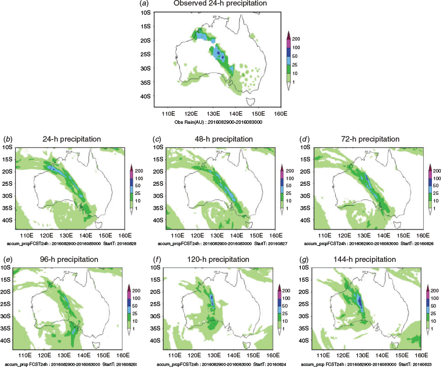
During the ‘August 16’ rainfall event in Australia, a rain area from 0000 UTC on 29 August to 0000 UTC on 30 August 2016 was located in the north of Western Australia, southwest of Northern Territory and South Australia, with a northwest–southeast belt shape (Fig. 12a). The daily precipitation on Marree station was 49.8 mm, and the forecasted maximum precipitation was about 70 mm near Marree. The ACCESS-APS2 global NWP shows a better forecast skill in predicting rainfall area and intensity 72 h in advance than that of ‘July 16’ case in China. For the rainfall intensity, its forecast of moderate rain was close to the observed, except that its 96–144 h forecasts were too weak and rainfall band too wide.
|
|
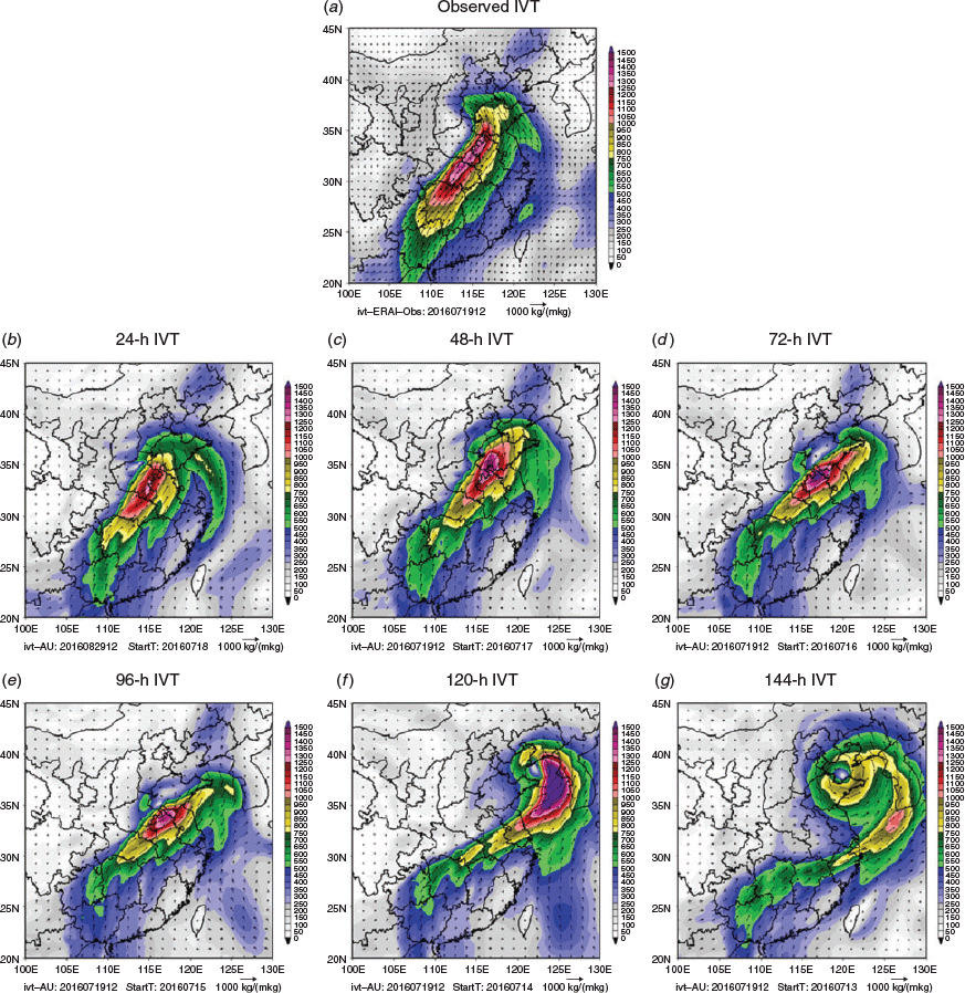
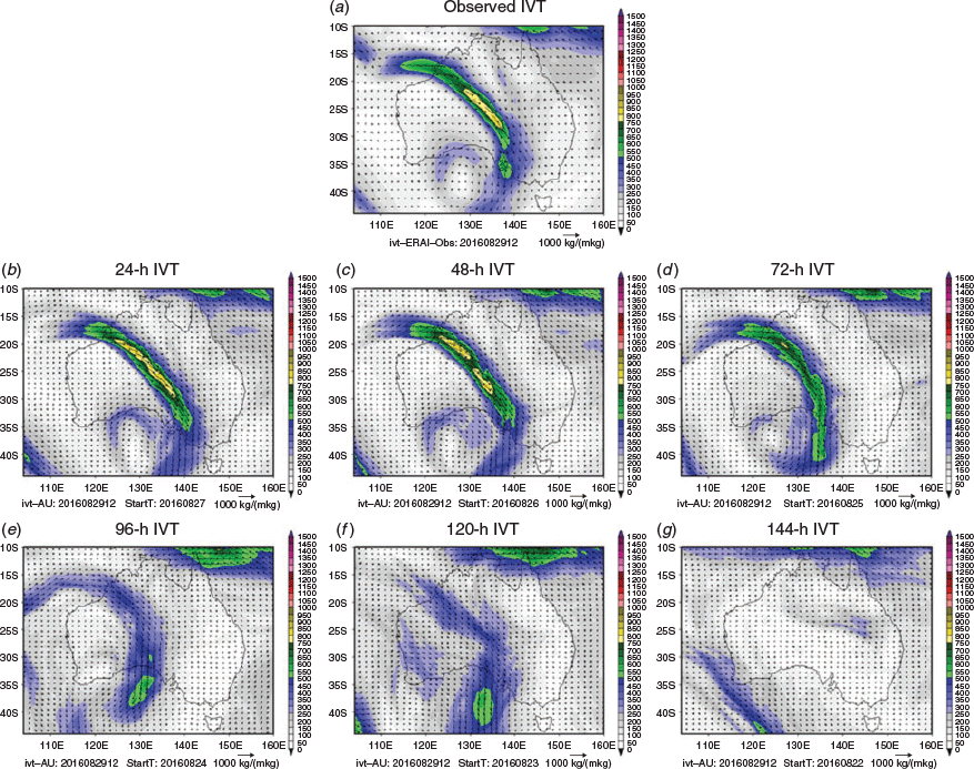
We now examine how well the ACCESS-APS2 NWP model forecasted the ARs during these two events. Fig. 13a shows the observed IVT during the peak of the 1200 UTC 19 July 2016 AR event, based on the JRA-55 reanalysis data. As discussed in Section 3, a significant feature of this rainfall event was the strong AR during the rainfall period, which brought significant warm and moist air from tropical waters into the region. For the operational forecasters, the challenge to predict the magnitude of this extreme rainfall event was that there was not enough confidence in their mind that during this season there would be such a large amount of moisture that can be transported into the interior region in North China (pers. comm. with Rong Yao, chief forecaster of the Hunan weather service). Therefore, the forecasters were hesitant to issue an extreme rainfall warning. From the ACCESS-APS2 NWP forecast of the AR evolution for this event, one can see that the model was able to predict strong and steady moisture supply from the tropics through an AR about four days ahead, which is one day earlier than its skilful rainfall forecast. During the 24–96 h forecast period, the model forecasted a large area with very high IVT with a clear band shape. Its 5–6 day forecast also predicted strong moisture supply from the south, but its vortex-like shape differed significantly from the JRA-55 reanalysis. It is worth noting that the ACCESS-APS2 NWP was skilful in predicting the extreme intensity of this AR process, with the model predicting above 1000 kg m−1 s−1 and even exceeded 1500 kg m−1 s−1 during this rainstorm event. Had the forecasters used this important information from the model, it was possible they would have been more confident to issue extremely intense rainfall forecasts during this event.
ACCESS-APS2 NWP had very skilful forecasts of the AR and NWCB event about 72 h ahead (Fig. 14). Its forecast at a 96-h lead time was weak and cannot reach the AR threshold, although it forecasted the possibility of belt-shaped water vapour transport and possible NWCB formation. Such skilful forecast of ARs would also be valuable to support the forecast of rainfall intensity and locations associated with this event.
It needs to be pointed out that in addition to the assessment of ACCESS-APS2 NWP skills for these two events, we also tried to assess the performance of the operational NWP from the NMC of the CMA. Nevertheless, due to limited data available for the analysis (results from its historical forecasts were only available for a 0–96 h lead time over the northern hemisphere), we could only do some very preliminary analysis (not shown) for the ‘July 16’ case in China. Results tended to suggest the NMC NWP had skilful AR forecasts and rainfall forecasts up to 72 h ahead, but its skill is lower than the ACCESS-APS2 at 96 h lead time. Conducting thorough comparisons of the operational NWP performance from CMA and BoM for AR and extreme rainfall forecasts in the A–A region is one of the key tasks in our future collaborative studies.
5 Conclusion and discussion
In recent years, several studies have demonstrated the role of the AR concept in characterising horizontal moisture transport leading to extreme rainfall generation (Ralph et al. 2004, 2006, 2017; Neiman et al. 2008a, 2008b; Roberge et al. 2009; Lavers et al. 2011, 2012; Newman et al. 2012; Lavers and Villarini 2013; Guan and Waliser 2015; Mahoney et al. 2016; Browning 2018; Zhang et al. 2019). Nevertheless, there are very limited studies on the significance of ARs affecting weather and climate in the A–A region (e.g. Yang et al. 2018). As part of the BoM–CMA collaboration on AR studies (Ye et al. 2020), this paper has made a comparative analysis of two typical AR cases in China and Australia. The event in China produced extreme rainfall in North China and caused many fatalities and significant damages, yet the operational rainfall forecast skill for this case was poor (Wang et al. 2017). The event in Australia was a classic NWCB (Tapp and Barrell 1984; Wright 1997; Telcik and Pattiaratchi 2014) event during which an extended cloud band formed across the continent and produced a rainfall belt that aligned with it. In our analysis, we studied the synoptic background of these two events, the moisture transport through the ARs, the vertical structure characteristics of these two ARs, and the trajectories of water vapour fed into the rainfall regions through the ARs. To further enhance our knowledge of AR and NWCB influence in the Australian region, we also paid particular attention to exploring the relationship between cloud vertical profiles and ARs. The classic AR conceptual model developed for the AR studies in North and South America (Gimeno et al. 2014) focused on the landing location of ARs and orographic uplift by coastal mountains in converting AR moisture into extreme rainfall. However, our analysis has shown a few different features in the A–A region. Our AR studies in East Asia focused more on the moisture transport embedded within monsoonal large-scale background flow and on studying how moisture is being transported within the monsoon domain, rather than its landing position. The AR study in the Australian region explored the potential of ARs to bring tropical, warm and moist air into the Australian continent to produce rainfall, given the fact that this continent is dominated by a dry and arid climate.
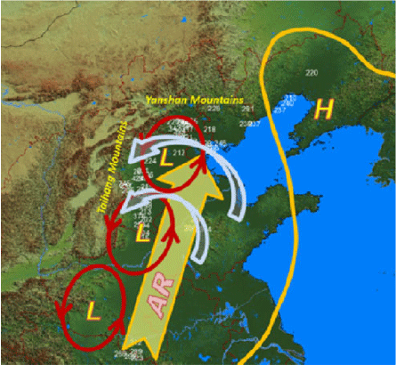
Through the case study in China we found that, due to the topographic orientation in East Asia, ARs are embedded in one of the three main moisture channels (i.e. the southwesterly flow from the Bay of Bengal, southerly flow from the South China Sea and south-easterly flow on the western flank of the WPSH) in the Asian monsoon system (Chen et al. 1991; Chang 2004; Wang 2006). In this case study, the AR operated along the topography that dominates the region. As shown by the schematic diagram in Fig. 15, the development and evolution of a cut-off low at the end of the AR pathway was the key factor for heavy precipitation generation in North China during the period from 19 to 21 July 2016. In this case, the AR brought strong and steady warm and moist air from tropics into North China. At the same time, a cut-off low developed and moved northward during the event. Associated with the cyclonic flow of the cut-off low, the dominant easterly low-level wind met with the upslope of the Taihang Mountains to the west. Its southerly wind met with the Yanshan Mountains in the north when the low moved northward. This cut-off low was the dynamical mechanism for converting the abundant warm and moist air transported by the AR into extreme precipitation. As a result, heavy rainfall was observed along the eastern side of the Taihang Mountains and southern side of the Yanshan Mountains. Therefore, although its maximum rainfall spatial pattern was similar to what is often observed in North and South America, where extreme precipitation is produced when ARs make landfall and meet with mountains along the west coasts (Dettinger et al. 2011; Ralph et al. 2011; Rivera et al. 2014), the underlying processes were different in this case study in China.
|
The AR case study in the Australian region also demonstrated the value of using ARs in understanding weather and climate in this region. We have shown that the moisture flux carried by the AR was much weaker here than in Asia, as it did not have a strong low-level jet to support strong moisture transport. The vertical level with maximum moisture transport was also higher in Australia than China. Nevertheless, the AR was still capable of bringing warm and moist air from the tropical Indian Ocean into the centre of the continent. The AR also acted as an important moisture source for the formation of the NWCB and its rainfall generation. The shape of the AR, in this case, was the product of a midlatitude frontal system interacting with a subtropical high to the north and east. In addition, due to the lack of mechanisms converging such moisture within the region, the AR rainfall efficiency was relatively low, and most of the moisture transport by the AR was lost at its outflow.
Furthermore, we examined the skill of the BoM NWP global model ACCESS-APS2 in forecasting ARs and rainfall in these two cases. It showed skilful AR forecasts about four days ahead of each event. For the case in China, this skill was better than its rainfall forecasts. Thus, ARs can be used to potentially bridge the gap between the model’s good skill in forecasting strong and steady moisture transport from the tropics into subtropics and relatively low rainfall forecast skill. In the Australian region, our case studies, together with more detailed NWCB analysis by Wu et al. (2020), also showed the value of using ARs in understanding the connection between NCWBs and rainfall in Australia.
Note that our analysis focused on case studies, and we did not discuss other importance aspects of ARs in the A–A region, such as their mean climatology, seasonality and interannual variations. These questions are addressed in other manuscripts included in this Research Front (Wu et al. 2020). This study is only our first attempt to apply AR analysis to give us new insight into the rainfall generations in the A–A region. Our analyses have demonstrated the value of continuing such investigations in future collaborations, such as assessing the potential predictability of ARs at multi-week and seasonal scale to support skilful rainfall forecasts at longer lead times (Liang et al. 2020; Ye et al. 2020) and comparing forecast skills from the operational systems in CMA and BoM.
Conflicts of interest
The authors declare no conflicts of interest.
Acknowledgments
The authors would like to thank the BoM and CMA for the agreement and support of this bilateral research project. The discussions with Drs A. Moise (BoM) and G. Martin and Peili Wu of UK Met Office are acknowledged. We also thank the constructive comments from Drs Lixin Qi (BNOC), Sugata Narsey and Tony Hirst during the internal review process. The constructive comments and suggestions from two anonymous reviewers are acknowledged. This research is supported by A BoM–CMA collaborative project (JWG–16 4.1), National Key R&D Program of China (2018YFC1507604) and Key Scientific Research Project of Hunan Meteorological Bureau (XQKJ17D001).
References
American Meteorological Society (2019). Atmospheric River. In Glossary of Meteorology. Available at http://glossary.ametsoc.org/wiki/Atmospheric_river.Bao, J.-W., Michelson, S. A., Neiman, P. J., Ralph, F. M., and Wilczak, J. M. (2006). Interpretation of enhanced integrated water vapor bands associated with extratropical cyclones: Their formation and connection to tropical moisture. Mon. Wea. Rev. 134, 1063–1080.
| Interpretation of enhanced integrated water vapor bands associated with extratropical cyclones: Their formation and connection to tropical moisture.Crossref | GoogleScholarGoogle Scholar |
Bauer, P., Thorpe, A., and Brunet, G. (2015). The quiet revolution of numerical weather prediction. Nature 525, 47–54.
| The quiet revolution of numerical weather prediction.Crossref | GoogleScholarGoogle Scholar | 26333465PubMed |
Browning, K. (2018). Atmospheric rivers in the U.K. Bull. Amer. Meteor. Soc. 99, 1108–1109.
| Atmospheric rivers in the U.K.Crossref | GoogleScholarGoogle Scholar |
BNOC (Bureau National Operations Centre) (2016). APS2 Upgrade to the ACCESS-G Numerical Weather Prediction System. BNOC Operations Bulletin Number 105. Bureau of Meteorology. 32pp.
Cai, W. J., and Cowan, T. (2008). Dynamics of late autumn rainfall reduction over southeastern Australia. Geophys. Res. Lett. 35, L09708.
| Dynamics of late autumn rainfall reduction over southeastern Australia.Crossref | GoogleScholarGoogle Scholar |
Chang, C. P. (2004). East Asian Monsoon. World Scientific Series on Meteorology of East Asia. World Scientific, 2, 564pp.
Chen, L. X., Zhu, Q. G., and Luo, H. B. (1991). East Asian Monsoon. China Meteorological Press, Beijing, 362pp. [in Chinese]
Dacre, H. F., Clark, P. A., Martinez-Alvarado, O., et al. (2015). How Do Atmospheric Rivers Form? Bull. Am. Meteorol. Soc. 96, 1243–1255.
| How Do Atmospheric Rivers Form?Crossref | GoogleScholarGoogle Scholar |
Dettinger, M. D., Ralph, F. M., Das, T., et al. (2011). Atmospheric rivers, floods and the water resources of California. Water 3, 445–78.
| Atmospheric rivers, floods and the water resources of California.Crossref | GoogleScholarGoogle Scholar |
Draxler, R. R., and Hess, G. D. (1998). An overview of the HYSPLIT_4 modeling system for trajectories, dispersion and deposition. Australian Meteorological Magazine 47, 295–308.
Ding, Y. (2004). Seasonal march of the East-Asian summer monsoon. ‘East Asian Monsoon.’ (Ed. C.-P. Chang) pp. 3–53. (World Scientific Publishing Co. Pte. Ltd.: Singapore.)
Eiras-Barca, J., Brands, S., and Miguez-Macho, G. (2016). Seasonal variations in North Atlantic atmospheric river activity and associations with anomalous precipitation over the Iberian Atlantic margin. J. Geophys. Res.: Atmos. 121, 931–948.
| Seasonal variations in North Atlantic atmospheric river activity and associations with anomalous precipitation over the Iberian Atlantic margin.Crossref | GoogleScholarGoogle Scholar |
Frederiksen, C. S., and Balgovind, R. C. (1994). The influence of the Indian Ocean/Indonesian SST gradient on the Australian winter rainfall and circulation in an atmospheric GCM. Quart. J. Roy. Meteor. Soc. 120, 923–952.
| The influence of the Indian Ocean/Indonesian SST gradient on the Australian winter rainfall and circulation in an atmospheric GCM.Crossref | GoogleScholarGoogle Scholar |
Fu, J. L., Ma, X. K., Chen, T., et al. (2017). Characteristics and Synoptic Mechanism of the July 2016 Extreme Precipitation Event in North China. Meteorol. Mon. 43, 528–539.
Gimeno, L., Nieto, R., Vázquez, M., et al. (2014). Atmospheric rivers: a mini-review. Front. Earth Sci. 2, 1–6.
| Atmospheric rivers: a mini-review.Crossref | GoogleScholarGoogle Scholar |
Gimeno, L., Dominguez, F., Nieto, R., et al. (2016). Major mechanisms of atmospheric moisture transport and their role in extreme precipitation events. Annu. Rev. Environ. Resour. 41, 117–114.
| Major mechanisms of atmospheric moisture transport and their role in extreme precipitation events.Crossref | GoogleScholarGoogle Scholar |
Guan, B., and Waliser, D. E. (2015). Detection of atmospheric rivers: Evaluation and application of an algorithm for global studies. J. Geophys. Res. Atmos. 120, 12514–12535.
| Detection of atmospheric rivers: Evaluation and application of an algorithm for global studies.Crossref | GoogleScholarGoogle Scholar |
He, J., Sun, C., Liu, Y., et al. (2007). Seasonal transition features of large-scale moisture transport in the Asian-Australian monsoon region. Adv. Atmos. Sci. 24, 1–14.
| Seasonal transition features of large-scale moisture transport in the Asian-Australian monsoon region.Crossref | GoogleScholarGoogle Scholar |
Huang, R. H., Zhang, Z. Z., Huang, G., et al. (1998). Characteristics of the Water Vapour Transport in East Asian Monsoon Region and Its Difference from that in South Asian Monsoon Region in Summer. Chin. J. Atmos. Sci. 22, 460–469.
Jiang, T., Evans, K., Deng, Y., et al. (2014). Intermediate frequency atmospheric disturbances: A dynamical bridge connecting western U.S. extreme precipitation with East Asian cold surges. J. Geophys. Res. Atmos. 119, 3723–3735.
| Intermediate frequency atmospheric disturbances: A dynamical bridge connecting western U.S. extreme precipitation with East Asian cold surges.Crossref | GoogleScholarGoogle Scholar |
Jones, D. A., Wang, W., and Fawcett, R. (2009). High-quality spatial climate data-sets for Australia. Aust. Meteorol. Oceanogr. J. 58, 233–248.
| High-quality spatial climate data-sets for Australia.Crossref | GoogleScholarGoogle Scholar |
Lavender, S. L., and Abbs, D. J. (2013). Trends in Australian rainfall: contribution of tropical cyclones and closed lows. Clim. Dyn. 40, 317–326.
| Trends in Australian rainfall: contribution of tropical cyclones and closed lows.Crossref | GoogleScholarGoogle Scholar |
Lavers, D. A., Allan, R. P., Wood, E. F., et al. (2011). Winter floods in Britain are connected to atmospheric rivers. Geophys. Res. Lett. 38, L23803.
| Winter floods in Britain are connected to atmospheric rivers.Crossref | GoogleScholarGoogle Scholar |
Lavers, D. A., Villarini, G., Allan, R. P., et al. (2012). The detection of atmospheric rivers in atmospheric reanalyses and their links to British winter floods and the large-scale climatic circulation. J. Geophys. Res. 117, D20106.
| The detection of atmospheric rivers in atmospheric reanalyses and their links to British winter floods and the large-scale climatic circulation.Crossref | GoogleScholarGoogle Scholar |
Lavers, D. A., and Villarini, G. (2013). The nexus between atmospheric rivers and extreme precipitation across Europe. Geophys. Res. Lett. 40, 3259–3264.
| The nexus between atmospheric rivers and extreme precipitation across Europe.Crossref | GoogleScholarGoogle Scholar |
Lavers, D., and Villarini, G. (2015). The contributions of atmospheric rivers to precipitation in Europe and the United States. J. Hydrol. 522, 382–390.
| The contributions of atmospheric rivers to precipitation in Europe and the United States.Crossref | GoogleScholarGoogle Scholar |
Liang, P., Dong, G., Zhang, H., Zhao, M., and Ma, Y. (2020). Atmospheric rivers in association with summer heavy rainfall over the Yangtze Plain. J. South. Hemisph. Earth Syst. Sci. , .
| Atmospheric rivers in association with summer heavy rainfall over the Yangtze Plain.Crossref | GoogleScholarGoogle Scholar |
Mahoney, K., Jackson, D. L., Neiman, P., Hughes, M., Darby, L., Wick, G., White, A., Sukovich, E., and Cifelli, R. (2016). Understanding the role of atmospheric rivers in heavy precipitation in the Southeast United States. Mon. Wea. Rev. 144, 1617–1632.
| Understanding the role of atmospheric rivers in heavy precipitation in the Southeast United States.Crossref | GoogleScholarGoogle Scholar |
Mo, R., Brugman, M. M., Milbrandt, J. A., Goosen, J., Geng, Q., Emond, C., Bau, J., and Erfani, A. (2019). Impacts of hydrometeor drift on orographic precipitation: Two case studies of landfalling atmospheric rivers in British Columbia, Canada. Wea. Forecasting 34, 1211–1237.
| Impacts of hydrometeor drift on orographic precipitation: Two case studies of landfalling atmospheric rivers in British Columbia, Canada.Crossref | GoogleScholarGoogle Scholar |
Mo, R., and Lin, H. (2019). Tropical-midlatitude interactions: Case study of an inland-penetrating atmospheric river during a major winter storm over North America. Atmos.-Ocean 57, 208–232.
| Tropical-midlatitude interactions: Case study of an inland-penetrating atmospheric river during a major winter storm over North America.Crossref | GoogleScholarGoogle Scholar |
Neiman, P. J., Ralph, F. M., Wick, G. A., et al. (2008a). Diagnosis of an intense atmospheric river impacting the Pacific Northwest: Storm summary and offshore vertical structure observed with COSMIC satellite retrievals. Mon. Wea. Rev. 136, 4398–4420.
| Diagnosis of an intense atmospheric river impacting the Pacific Northwest: Storm summary and offshore vertical structure observed with COSMIC satellite retrievals.Crossref | GoogleScholarGoogle Scholar |
Neiman, P. J., Ralph, F. M., Wick, G. A., et al. (2008b). Meteorological Characteristics and Overland Precipitation Impacts of Atmospheric Rivers Affecting the West Coast of North America Based on Eight Years of SSM/I Satellite Observations. J. Hydrometeor. 9, 22–47.
| Meteorological Characteristics and Overland Precipitation Impacts of Atmospheric Rivers Affecting the West Coast of North America Based on Eight Years of SSM/I Satellite Observations.Crossref | GoogleScholarGoogle Scholar |
Newell, R. E., Newell, N. E., Zhu, Y., et al. (1992). Tropospheric rivers-A pilot study. Geophys. Res. Lett. 12, 2401–2404.
| Tropospheric rivers-A pilot study.Crossref | GoogleScholarGoogle Scholar |
Newman, M., Kiladis, G. N., Weickmann, K. M., et al. (2012). Relative contributions of synoptic and low-frequency eddies to time-mean atmospheric moisture transport, including the role of atmospheric rivers. J. Climate 25, 7341–7361.
| Relative contributions of synoptic and low-frequency eddies to time-mean atmospheric moisture transport, including the role of atmospheric rivers.Crossref | GoogleScholarGoogle Scholar |
Qi, L., Leslie, L. M., and Zhao, S. X. (1999). Cut-off low pressure systems over southern Australia: climatology and case study. Int. J. Clim. 19, 1633–1649.
| Cut-off low pressure systems over southern Australia: climatology and case study.Crossref | GoogleScholarGoogle Scholar |
Quan, W. Q., and He, L. F. (2016). Analysis of the July 2016 Atmospheric Circulation and Weather. Meteorol. Mon. 42, 1283–1288.
Ralph, F. M., Dettinger, M., Lavers, D., et al. (2017). Atmospheric rivers emerge as a global science and applications focus. Bull. Amer. Meteor. Soc. 98, 1969–1973.
| Atmospheric rivers emerge as a global science and applications focus.Crossref | GoogleScholarGoogle Scholar |
Ralph, F. M., Neiman, P. J., and Wick, G. A. (2004). Satellite and CALJET aircraft observations of atmospheric rivers over the eastern North Pacific Ocean during the winter of 1997/98. Mon. Wea. Rev. 132, 1721–1745.
| Satellite and CALJET aircraft observations of atmospheric rivers over the eastern North Pacific Ocean during the winter of 1997/98.Crossref | GoogleScholarGoogle Scholar |
Ralph, F. M., Neiman, P. J., Wick, G. A., et al. (2006). Flooding on California’s Russian River: Role of atmospheric rivers. Geophys. Res. Lett. 33, L13801.
| Flooding on California’s Russian River: Role of atmospheric rivers.Crossref | GoogleScholarGoogle Scholar |
Ralph, F. M., Coleman, T., Neiman, P. J., et al. (2013). Observed impacts of duration and seasonality of atmospheric-river landfalls on soil moisture and runoff in coastal northern California. J. Hydrometeor. 14, 443–459.
| Observed impacts of duration and seasonality of atmospheric-river landfalls on soil moisture and runoff in coastal northern California.Crossref | GoogleScholarGoogle Scholar |
Ralph, F. M., Neiman, P. J., Kiladis, G. N., et al. (2011). A multiscale observational case study of a Pacific atmospheric river exhibiting tropical-extratropical connections and a mesoscale frontal wave. Mon. Wea. Rev. 139, 1169–89.
| A multiscale observational case study of a Pacific atmospheric river exhibiting tropical-extratropical connections and a mesoscale frontal wave.Crossref | GoogleScholarGoogle Scholar |
Ralph, F. M., Rutz, J. J., Cordeira, J. M., et al. (2019). A scale to characterize the strength and impacts of atmospheric rivers. Bull. Amer. Meteor. Soc. 100, 269–289.
| A scale to characterize the strength and impacts of atmospheric rivers.Crossref | GoogleScholarGoogle Scholar |
Rivera, E. R., Dominguez, F., and Castro, C. L. (2014). Atmospheric rivers and cool season extreme precipitation events in the Verde River basin of Arizona. J. Hydrometeor. 15, 813–829.
| Atmospheric rivers and cool season extreme precipitation events in the Verde River basin of Arizona.Crossref | GoogleScholarGoogle Scholar |
Roberge, A., Gyakum, J. R., Atallah, E. H., et al. (2009). Analysis of intense poleward water vapor transports into high latitudes of western North America. Wea. Forecasting 24, 1732–1747.
| Analysis of intense poleward water vapor transports into high latitudes of western North America.Crossref | GoogleScholarGoogle Scholar |
Saha, S., Moorthi, S., Wu, X., et al. (2014). The NCEP climate forecast system versions 2. J. Climate 27, 2186–2208.
| The NCEP climate forecast system versions 2.Crossref | GoogleScholarGoogle Scholar |
Simmonds, I., Bi, D. H., Hope, P., et al. (1999). Atmospheric Water Vapour Flux and Its Association with Rainfall over China in Summer. J. Climate 12, 1353–1367.
| Atmospheric Water Vapour Flux and Its Association with Rainfall over China in Summer.Crossref | GoogleScholarGoogle Scholar |
Speer, M. S., Leslie, L. M., and Fierro, A. O. (2011). Australian east coast rainfall decline related to large scale climate drivers. Clim. Dyn. 36, 1419–1429.
| Australian east coast rainfall decline related to large scale climate drivers.Crossref | GoogleScholarGoogle Scholar |
Stan, C., Straus, D. M., Frederiksen, J. S., Lin, H., Maloney, E. D., and Schumacher, C. (2017). Review of tropical-extratropical teleconnections on intraseasonal time scales. Rev. Geophys. 55, 902–937.
| Review of tropical-extratropical teleconnections on intraseasonal time scales.Crossref | GoogleScholarGoogle Scholar |
Stunder, B. J. B. (1996). An assessment of the quality of forecast trajectories. J. Appl. Meteor. 35, 1319–1331.
| An assessment of the quality of forecast trajectories.Crossref | GoogleScholarGoogle Scholar |
Tao, S. Y., and Chen, L. (1987). A review of recent research on the East Asian summer monsoon. In ‘China Monsoon Metorology.’ (Eds C. P. Chang and T. N. Krishnamurti.) pp. 60–92. (Oxford University Press.)
Tapp, R. G., and Barrell, S. L. (1984). The north-west Australian cloud band: Climatology, characteristics and factors associated with development. Int. J. Clim. 4, 411–424.
| The north-west Australian cloud band: Climatology, characteristics and factors associated with development.Crossref | GoogleScholarGoogle Scholar |
Telcik, N., and Pattiaratchi, C. (2014). Influence of Northwest Cloudbands on Southwest Australian Rainfall. J. Climate 2014, 671394.
| Influence of Northwest Cloudbands on Southwest Australian Rainfall.Crossref | GoogleScholarGoogle Scholar |
Ummenhofer, C. C., Sen, G. A., Pook, M. J., et al. (2008). Anomalous Rainfall over Southwest Western Australia Forced by Indian Ocean Sea Surface Temperatures. J. Climate 21, 5113–5134.
| Anomalous Rainfall over Southwest Western Australia Forced by Indian Ocean Sea Surface Temperatures.Crossref | GoogleScholarGoogle Scholar |
Ummenhofer, C. C., Sen Gupta, A., Briggs, P. R., et al. (2011). Indian and Pacific ocean influences on southeast Australian drought and soil moisture. J. Climate 24, 1313–1336.
| Indian and Pacific ocean influences on southeast Australian drought and soil moisture.Crossref | GoogleScholarGoogle Scholar |
van der Ent, R. J., Savenije, H. H. G., Schaefli, B., et al. (2010). Origin and fate of atmospheric moisture over continents. Water Resour. Res. 46, W09525.
| Origin and fate of atmospheric moisture over continents.Crossref | GoogleScholarGoogle Scholar |
Viale, M., Valenzuela, R., Garreaud, R. D., Ralph, F. M., et al. (2018). Impacts of atmospheric rivers on precipitation in southern South America. J. Hydrometeor. 19, 1671–1687.
| Impacts of atmospheric rivers on precipitation in southern South America.Crossref | GoogleScholarGoogle Scholar |
Wang, B. (2006). The Asian monsoon. Praxis Publishing, Chichester, 787pp.
Wang, L. P., Zhang, J. Z., Wang, W. G., et al. (2017). Decision-making Meteorological Service Analysis on “2016-July” Extreme Precipitation in the area from Jianghan to Huanghuai and North China. J. Inst. Disaster Prev. 19, 63–70.
Wick, G. A. (2014). Implementation and initial application of an atmospheric river detection tool based on integrated vapour transport. American Geophysical Union, Fall Meeting 2014, San Francisco, CA, USA. Abstract id A34E-06.
Wick, G. A., Neiman, P. J., and Ralph, F. M. (2013). Description and validation of an automated objective technique for identification and characterization of the integrated water vapour signature of atmospheric rivers. IEEE Trans. Geosci. Remote Sens. 51, 2166–2176.
| Description and validation of an automated objective technique for identification and characterization of the integrated water vapour signature of atmospheric rivers.Crossref | GoogleScholarGoogle Scholar |
Wright, W. J. (1997). Tropical–extratropical cloudbands and Australian rainfall: I. climatology. Int. J. Clim. 17, 807–829.
| Tropical–extratropical cloudbands and Australian rainfall: I. climatology.Crossref | GoogleScholarGoogle Scholar |
Wu, X., Ye, C., He, W., Chen, J., Xu, L., and Zhang, H. (2020). Atmospheric rivers impacting mainland China and Australia: climatology and interannual variations. J. South. Hemisph. Earth Syst. Sci. , .
| Atmospheric rivers impacting mainland China and Australia: climatology and interannual variations.Crossref | GoogleScholarGoogle Scholar |
Yang, Y., Zhao, T., Ni, G., et al. (2018). Atmospheric rivers over the Bay of Bengal lead to northern Indian extreme rainfall. Int. J. Climatol. 38, 1010–1021.
| Atmospheric rivers over the Bay of Bengal lead to northern Indian extreme rainfall.Crossref | GoogleScholarGoogle Scholar |
Ye, C. Z., Zhang, H. Q., Moise, A., and Mo, R. P. (2020). Atmospheric rivers in the Australia-Asian Region: a BoM-CMA collaborative study. J. South. Hemisph. Earth Syst. Sci. , .
| Atmospheric rivers in the Australia-Asian Region: a BoM-CMA collaborative study.Crossref | GoogleScholarGoogle Scholar |
Zhang, H. (2010). Diagnosing Australia-Asian monsoon onset/retreat using large-scale wind and moisture indices. Clim. Dyn. 35, 601–618.
| Diagnosing Australia-Asian monsoon onset/retreat using large-scale wind and moisture indices.Crossref | GoogleScholarGoogle Scholar |
Zhang, Z., Ralph, F. M., and Zheng, M. (2019). The relationship between extratropical cyclone strength and atmospheric river intensity and position. Geophys. Res. Lett. 46, 1814–1823.
| The relationship between extratropical cyclone strength and atmospheric river intensity and position.Crossref | GoogleScholarGoogle Scholar |
Zhu, Y., and Newell, R. E. (1994). Atmospheric rivers and bombs. Geophys. Res. Lett. 21, 1999–2002.
| Atmospheric rivers and bombs.Crossref | GoogleScholarGoogle Scholar |
Zhu, Y., and Newell, R. (1998). A proposed algorithm for moisture fluxes from atmospheric rivers. Mon. Wea. Rev. 126, 725–735.
| A proposed algorithm for moisture fluxes from atmospheric rivers.Crossref | GoogleScholarGoogle Scholar |

