
Atmospheric rivers associated with summer heavy rainfall over the Yangtze Plain
Ping Liang A B D , Guangtao Dong A , Huqiang Zhang C , Mei Zhao C and Yue Ma AA Key Laboratory of Cities’ Mitigation and Adaptation to Climate Change in Shanghai, Shanghai Regional Climate Center, CMA, Shanghai, China.
B The Institute of Climate and Application Research, Nanjing University of Information Science and Technology, Nanjing, China.
C Bureau of Meteorology, Melbourne, Australia.
D Corresponding author. Email: liangping1107@163.com
Journal of Southern Hemisphere Earth Systems Science 70(1) 54-69 https://doi.org/10.1071/ES19028
Submitted: 25 July 2019 Accepted: 27 November 2019 Published: 17 September 2020
Journal Compilation © BoM 2020 Open Access CC BY-NC-ND
Abstract
Atmospheric rivers (ARs) are long, narrow bands of enhanced water vapour transport in the low atmosphere, mainly from the tropics into the midlatitudes. However, it is still unclear how ARs act on different timescales during the boreal summer when frequent heavy precipitation events take place in East Asia, often resulting in severe flood that impacts property and human lives. In this study, we investigated climatological ARs, and their evolution on both synoptic and subseasonal timescales, associated with heavy rainfall events over the Yangtze Plain in China. Furthermore, their predictability was assessed by examining hindcast skills from an operational coupled seasonal forecast system of the Australian Bureau of Meteorology named ACCESS-S1. Results showed that ARs embedded within the South Asian monsoon and Somali cross-equatorial flow provide a favourable background for steady moisture supply of summer rainfall into East Asia. We call this favourable background a ‘climatological East Asian AR’, which has close connections with seasonal cycles and climatological intraseasonal oscillation of rainfall in the Yangtze Plain during its Meiyu season. The East Asian AR was also influenced by anomalous anticyclonic circulations over the tropical West Pacific when heavy rainfall events occurred over the Yangtze Plain. Different from orography-induced precipitation, ARs that led to heavy rainfall over the Yangtze Plain were linked with the intrusions of cold air from the north. The major source of ARs responsible for heavy precipitation events over the Yangtze Plain appeared to originate from the tropical West Pacific on both synoptic and subseasonal timescales. In 23-year hindcasts for May-June-July the current model, ACCESS-S1, had skillful rainfall forecasts at a lead time of 0 month, but the skill degraded significantly with longer lead times. Nevertheless, the model showed skills in predicting the variations of low-level moisture transport affecting the Yangtze River at longer lead time, suggesting that the ARs influencing summer monsoon rainfall in the East Asian region are likely to be more predictable than rainfall itself. There is potential in using AR predictions from the coupled forecast system to guide rainfall forecasts in the East Asian summer season at longer lead time, which can contribute to disaster prevention and reduction in East Asia.
Keywords: atmospheric rivers, East Asia, heavy rainfall, intraseasonal oscillation, monsoon, predictability, subseasonal forecasts, West Pacific, Yangtze Plain.
1 Introduction
Water cycles and associated moisture transport has long been an active research area due to their important roles on regional and global weather and climate systems. Atmospheric rivers (ARs), characterised as narrow corridors or filaments of concentrated moisture transport in the atmosphere (e.g. Newell et al. 1992; Zhu and Reginald 1994), play an important role in influencing weather and climate (e.g. Guan and Waliser 2015). In recent years, AR research has become a global science and application focus (Ralph et al. 2017), especially since objective identifications of ARs were put forward (e.g. Neiman et al. 2009; Lavers et al. 2011; Wick et al. 2013). Meanwhile, ARs are increasingly recognised as one of the major causes of heavy precipitation and floods over midlatitude landmasses, such as western USA, where an AR connected to the tropical moisture source near Hawaii is called the ‘Pineapple Express‘ (Higgins et al. 2000; Ralph et al. 2006; Dettinger 2011; Neiman et al. 2011); West Europe (Lavers et al.2011); and South America (Viale and Nunez 2011). ARs contributing to topographically induced floods were the primary focus in the above studies. Nevertheless, as pointed out by Ye et al. (2020), there is a lack of AR analysis in the East Asian region, with a number of key questions remaining: are there ARs in East Asia? If yes, how do ARs connect with heavy precipitation in East Asia, especially over plain regions where the orographic influence is weak? These questions are elusive because of the high complexity of underlying dynamics and physics governing the East Asian monsoon. Therefore, there is an urgent need to conduct more thorough analysis of ARs in the East Asian region.
Summer rainfall over East Asia is controlled by the Asian summer monsoon system (Ding 1994), which provides the circulation background favouring moisture transport from tropical oceans into the region. As reviewed in Ye et al. (2020), the sources of moisture transport for summer rainfall in East Asia can be roughly categorised into three channels: (i) the moisture transport from the Bay of Bengal (BoB) by the Indian monsoon; (ii) from the South China Sea by cross-equatorial flow; and (iii) from the western tropical Pacific by the anticyclonic flow over the south and west sides of the West Pacific subtropical high (WPSH) (e.g. Tao and Chen 1987; Simmonds et al. 1999; Ding and Sun 2001; Zhang 2001; Liang et al. 2005; Zhu et al. 2014; He and Zhu 2015; Zhu and Li 2016). However, we do not fully understand the relationship between the frequency and intensities of ARs occurring in the region with the strength of the monsoon circulation. It is unclear whether a strong monsoon means more ARs during the monsoon season or it means more northeastward penetrations of ARs. These areas are being addressed by the Asian–Australian (A–A) AR project described in Ye et al. (2020).
The importance of studying ARs in the East Asian region is further underlined by the current assessment that the risk of extreme precipitation is likely to increase in the East China region under the combined impacts of global warming and urbanization. Global warming is likely to result in precipitation intensification via increased water vapour content of the atmosphere (e.g. Trenberth 2005; Zhang et al. 2012; IPCC 2013). Regional urbanization also provides a favourable background for extreme precipitation, including enhanced moisture convergence and atmospheric instability (e.g. Liang and Ding 2017). Taking China as an example, the frequency of extremely heavy precipitation events has significantly increased during the last half century (Wang and Zhou 2005). In recent years, many Chinese cities, including metropolises such as Beijing (Yin et al. 2011) and Shanghai (Liang and Ding 2017), have frequently suffered more severe floods and more ‘city sea views’ phenomena during the flooding season, and flood events often resulted in significant fatalities and property damages. Studies on ARs in association with heavy rainfall events are therefore of great importance for the alleviation of flood disasters in the densely populated East Asia.
Considering the issues mentioned above, in this study, we investigated the characteristics of the ARs over East China that caused large-scale and persistent heavy rainfall events both on synoptic and subseasonal timescales. We also studied the forecast potentials of ARs and rainfall on subseasonal timescales in the East Asian summer monsoon region based on a current coupled seasonal forecast system.
The remainder of this paper is arranged as follows. Section 2 describes the study area, data and methods used in the study. Features of heavy precipitation events in East China are analysed in Section 3. The climatological ARs and their evolutions on synoptic and subseasonal timescales in association with heavy rainfall events in the region are also investigated in Section 3. The seasonal forecast potentials of extreme rainfall and its associated ARs are discussed in Section 4. Finally, Section 5 is used to summarise the findings from this study and discuss some future research plans.
2 Data and methodology
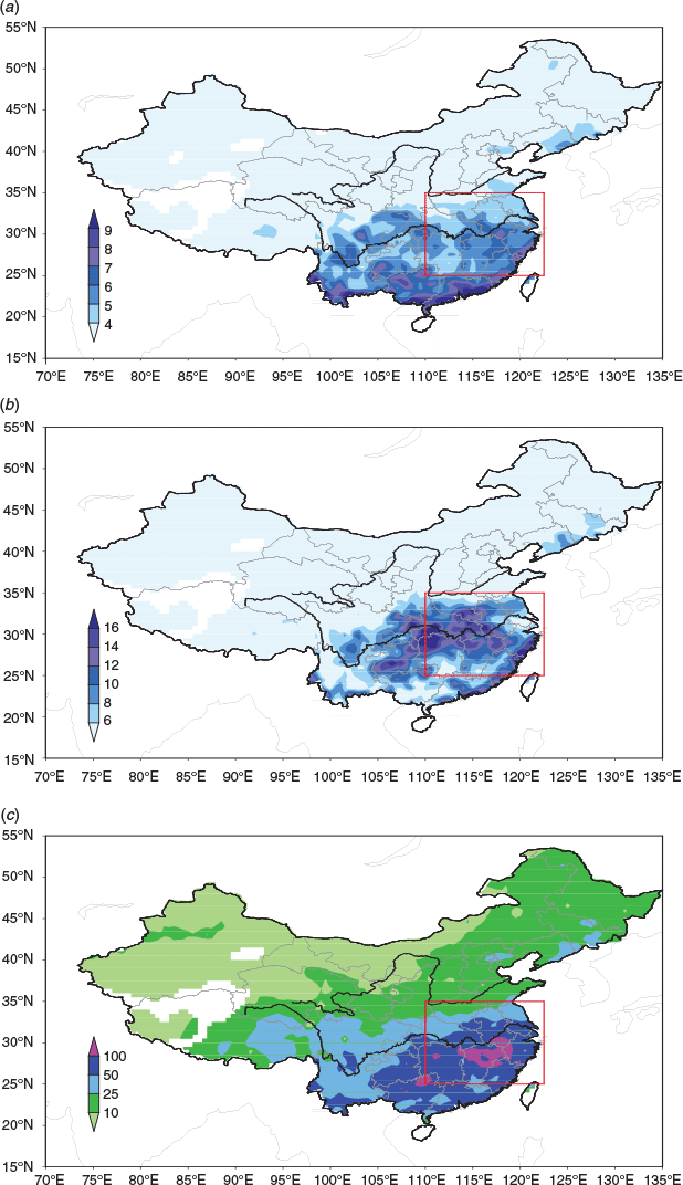
The data used in this study were as follows: (i) daily mean atmospheric circulation data with a 2.5° × 2.5° horizontal resolution from the National Centers for Environmental Prediction (NCEP)/National Center for Atmospheric Research (NCAR) Reanalysis I (NN-R1) (Kalnay et al. 1996), including horizontal wind components u and v, and specific humidity at eight pressure levels (1000, 925, 850, 700, 600, 500, 400 and 300 hPa) for 1981–2010; (ii) daily rainfall dataset collected from 740 weather stations covering mainland China, available from the National Meteorological Information Center of the China Meteorological Administration for the same period; (iii) daily outgoing long wave radiation from the National Oceanic and Atmospheric Administration (Liebmann and Smith 1996). Here, the boreal summer flood season refers to the June-July-August-September (JJAS) period. Note that the daily rainfall dataset used in this analysis has been under strict quality control and used by many other studies (e.g. Wang and Zhou 2005). In our analysis, stations with less than 30-year observations were eliminated, and the resulting 669 stations were used. Fig. 1 shows the spatial coverage of these stations and the area focused on in this analysis. The Yangtze Plain region, as the study domain of this analysis, is characterised by low elevations, with most of the rainfall stations lower than 50 meters above sea level. Therefore, the topographic influence on rainfall extremes was expected to be weak over this domain.

|
Floods in the middle and lower reaches of the Yangtze River Basin are usually associated with large-scale, persistent heavy precipitation events. In this study, heavy rainfall was defined as the 85th percentile of daily precipitation in the summer seasons of 1981–2010. This definition is widely adopted for the studies of extreme precipitation in China (Liang and Ding 2017). A large-scale persistent heavy rainfall event was further defined when one third of stations within the study domain in Fig. 1 satisfied the threshold of heavy rainfall for at least five consecutive days. Accordingly, a total of 66 events during JJAS of 1981–2010 were analysed in this study.
As in many AR detection studies (e.g. Guan and Waliser 2015; Ye et al. 2020), we used the integrated water vapour transport (IVT) to detect ARs in our study. The IVT vectors are expressed as follows:
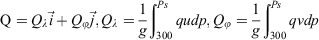
where Q represents the vertically integrated water vapor transport from surface to 300 hPa, l denotes longitude and latitude, g the acceleration of gravity, Ps the surface pressure, q specific humidity, u and v the zonal and meridional components of the horizontal wind vector v, and dp the vertical pressure difference between two atmospheric levels. Following Guan and Waliser 2015 and adopted by studies in this AR project, IVT-based ARs were detected when they satisfied two criteria: (i) IVT exceeded 250 kg m−1s−1; and (ii) the AR’s length was longer than 2000 km and the length-width ratio was ≥2. Similar spatial distributions of climatological and composite ARs can be discriminated by both the IVT criterion of regular ARs (250 kg m−1 s−1) and lower criterion (e.g. 200 kg m−1 s−1) due to the narrow feature of ARs. Therefore, IVT above 250 kg m−1 s−1 was also adopted to define climatological and composite ARs.
In addition, Morlet wavelet (Grossmann and Morlet,1984) time-frequency analysis and the Ensemble Empirical Mode Decomposition (EEMD; Wu and Huang 2005, 2009) method for processing nonlinear and nonstationary series were used in the periodic analysis of ARs in the region. The detailed steps of EEMD can be found in Liang and Ding 2017. In addition, the Butterworth filter (Krishnamurti and Gadgil 1985) was used to obtain low frequency oscillation components of time series when we investigated the temporal variations of extreme rainfall and moisture transport in the region.
In the study, hindcast results from the current operational coupled seasonal forecast model in the Australian Bureau of Meteorology, named ACCESS-S1 (Hudson et al. 2017, 2018), were analysed to investigate the potential predictability of ARs and summer rainfall over the Yangtze Plain. The system was based on the UK Met office Global Seasonal forecast system version 5, using the Global Coupled model configuration 2 (MacLachlan et al. 2015; Williams et al. 2015). But, the new generation operational seasonal prediction system of the Bureau of Meteorology, ACCESS-S1, has a new initial perturbation scheme for generating atmosphere initial conditions in ensemble runs. More details can be found in Hudson et al. (2017, 2018) and Zhao et al. (2019). In this paper, we focused on analysing a set of three-month hindcasts starting on 1 May for 1990–2012 with an 11-member ensemble (Hudson et al. 2017, 2018). By comparing with ERA-Interim (Dee et al. 2011) reanalysis as an observational approximation, we calculated anomaly correlation coefficients (ACCs) to evaluate the forecast skills for horizontal atmospheric moisture transport on subseasonal and seasonal timescales over the Yangtze Plain. In the model rainfall skill assessment, the gridded precipitation dataset (CN05.1) derived from the Beijing Climate Center and based on over 2400 station observations in China (e.g. Wu and Gao 2013; Huang et al. 2014) was used to evaluate the precipitation forecast skill of the ACCESS-S1 model.
3 Features of ARs in association with heavy rainfall
As shown by Fig. 2a, the climatological daily summer rainfall (JJAS) over the Yangtze Plain is about 4–7 mm day−1. According to our definition mentioned in Section 2, when large-scale persistent heavy rainfall events occurred (with one third of stations within the study domain having heavy rainfall for at least five consecutive days), the majority of stations in the study domain reached 8–14 mm day−1 (Fig. 2b), i.e. double the average rainfall during summer. Fig. 2c also shows that the corresponding cumulative precipitation for large-scale persistent rainfall events was above 50 mm and up to 100 mm for extreme rainstorms. Note that Fig. 2b shows the daily rainfall intensity averaged from these 66 events. Thus, it could have some different spatial patterns to the averaged accumulative precipitation for these events due to their different durations (Fig. 2c). Nevertheless, both measurements showed that extreme rainfall always occurred over the middle reach of the Yangtze River Basin. We now present characteristics of horizontal moisture transport associated with these rainfall extremes.
|
3.1 Monsoon background of ARs
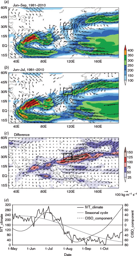
As a classic monsoon region (Zhang et al. 2012), East China, especially the Yangtze Plain, is significantly influenced by the Asian monsoon system. Fig. 3a shows vertically integrated horizontal moisture transport over the Asian monsoon domain calculated by IVT. These are the results from the 30-year NCAR/NCEP reanalysis data. We further termed them ‘climatological ARs’ if the magnitudes and the shapes of these climatological IVT satisfied the same threshold used for defining ARs from Guan and Waliser 2015, as mentioned in Section 2. It needs to be pointed out that ‘climatological ARs’ here mainly uses the AR concept to characterise the averaged spatial patterns and intensities of meridional moisture transport in the Asian monsoon climate. Climatological ARs are different from regular ARs, which are directly related to individual heavy precipitation events on a synoptic timescale. In a future study, we will explore the extent to which these climatological ARs are produced by ARs operating at a synoptic timescale. In Fig. 3 we can see that there are three strong IVT branches towards the south boundary of the Yangtze Plain. One branch comes from Indian Ocean and the BoB, which is associated with South Asian monsoon. As this IVT shape satisfied the criteria for defining an AR by Guan et al. (2015), we considered this a climatological AR in the summer. The formation of this AR orientation can be attributed to both the topographic blocking effect by the Tibetan–Iran plateau (Boos and Kuang 2010) as well as its heating effect (Wu et al. 2012). Besides this strong IVT branch, there were two additional IVT branches: (i) from the South China Sea region as the cross-equatorial flow from the southern hemisphere, and (ii) as the anticyclonic subtropical monsoon flow south and west of the WPSH. Although both carry huge amounts of moisture, the latter two climatological IVT belts could not be called ARs, as their shapes hardly satisfied the AR criteria.
|
Fig. 3b shows the climatological IVT during the peak Meiyu season of June–July in the Yangtze Plain. Besides the climatological South Asian AR in summer, there was an enhanced AR extending from south of the Yangtze Plain to the Northwest Pacific via south Japan. This climatological East Asian AR corresponded well to the strong IVT of East Asian Meiyu occurring in June–July. The climatological East Asian AR was closely linked to an enhanced Asian summer monsoon, especially with the strengthened and more westward extension of the WPSH (Fig. 3c).
Fig. 3d further separates the climatological intraseasonal oscillation (CISO, Wang and Xu 1997) components of IVT against its seasonal cycle by using EEMD analysis of spatially averaged IVT over the Yangtze Plain. The seasonal cycle and CISO components explained 48.2% and 16.0% of the variance of the total IVT, respectively. It can be clearly seen that both seasonal cycle and intraseasonal component of IVT are strong over the Yangtze Plain during East Asian monsoon development. Whether these intraseasonal IVT variations are linked to the pronounced Asian monsoon intraseasonal variability needs further analysis.
3.2 Composite IVT of heavy rainfall events
Fig. 4a illustrates the composite IVT patterns during the period of large-scale persistent heavy rainfall processes for the 66 cases over the Yangtze Plain. It was evident that there was a long and narrow IVT belt, like an AR, extending from south of the Yangtze Plain to the Northwest Pacific. As the start point of the East Asian AR, the strong IVT over the south Yangtze Plain was tracked back to moisture from South Asia, the cross-equatorial flow of monsoon and the transport from the flow west of the WPSH. Compared with the summer climatological AR (Fig. 3a), there were two distinct IVT features associated with this climatological AR: (i) the rotating IVT over the west of WPSH moved northward to the south Yangtze Plain from the South China Sea (Fig. 4a); (ii) the IVT from the cross-equatorial flow from tropical Australia and the maritime continent strengthened over the Indochina Peninsula and weakened over the west of the Philippines. Note that our current analysis only shows that, at climate timescale, there are moisture transports in the Asian monsoon region that meet the AR threshold. Nevertheless, from our current analysis, we could not answer if these climatological ARs were the composite of each individual AR at synoptic scale, or if they represented a steady monsoonal flow in the region. This deserves further exploration in future studies.

|
The anomalous IVT, i.e. the averaged departure of IVT during the heavy precipitation events against climatological IVT, is further shown in Fig. 4b. Note that the IVT anomaly for a particular day was calculated as the departure of that day from its corresponding pentad-mean for 1981–2010. Fig. 4b shows that the AR influencing the Yangtze Plain is associated with the anticyclonic IVT anomaly over the South China Sea to the West Pacific and the cyclonic IVT anomaly over the northern part of the Yangtze River to the west of Japan. Thus, there was a strong IVT convergence occurring over the Yangtze Plain that contributed to the formation of its heavy rainfall events. Different from the mechanism of heavy rainfall caused by ARs encountering mountains in most studies on the west coasts of North America (e.g. Higgins et al. 2000; Ralph et al. 2006; Dettinger 2011; Neiman et al. 2011), the lifting mechanism for the AR-induced severe rainfall over the Yangtze Plain was mainly the dynamical forcing of the anomalous southward cold air from Northeast Asia. This agrees with the case study by Chen et al. (2020), which reported that an AR-induced heavy rainfall in North China was the coproduct of warm and moist air transported into the region by an AR and the interaction with a cold air mass from its north.
3.3 Moisture sources for AR-induced heavy rainfall events
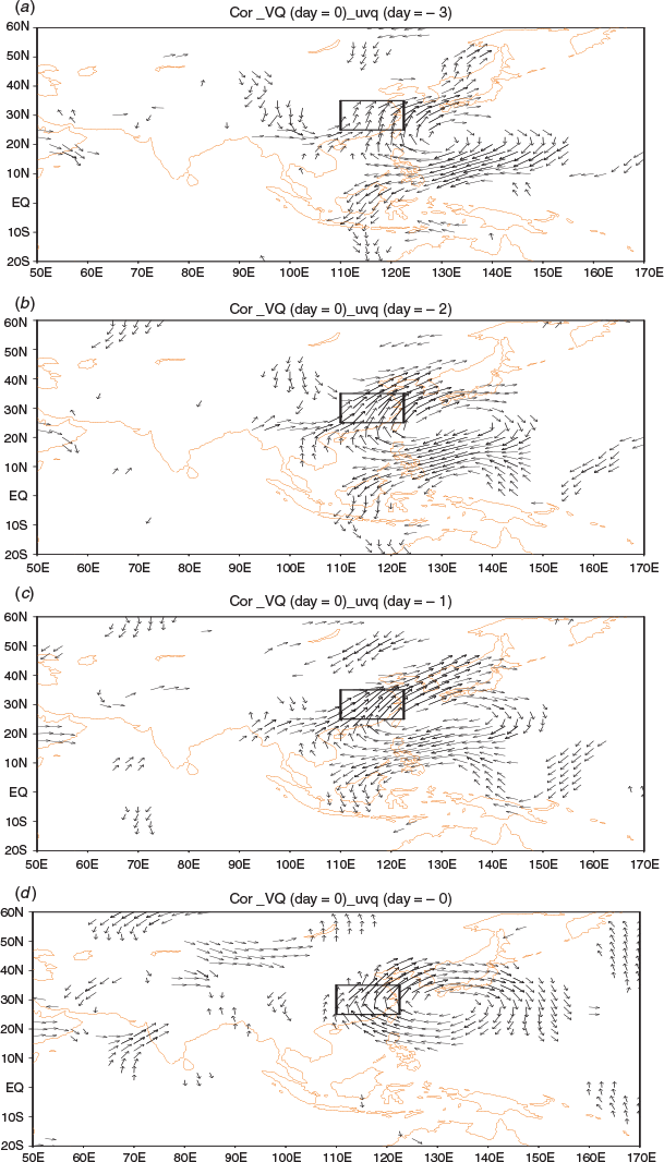
To explore the connection between meridional moisture transport into East China and the surrounding large-scale atmospheric circulation, we show in Fig. 5 the correlations between the meridional components of IVT averaged over the Yangtze Plain and the IVT in the rest of the A–A monsoon domain with different lead times (0 to 3-day) for the 66 heavy rainfall events defined in Section 2. A remarkable feature in Fig. 5 is that before the occurrences of heavy precipitation in the Yangtze Plain, there was often an enhanced northward moisture transport associated with an anticyclonic IVT pattern over the South China Sea and tropical West Pacific associated with an enhanced WPSH. The strengthened IVT favoured the northeastward inland penetration of ARs that originated in the tropical Indian Ocean and BoB, as shown in Fig. 4. Note that Fig. 5 shows the correlations rather than the IVTs themselves; therefore, the lack of signal over the Indian Ocean and BoB in Fig. 5 does not mean there was no moisture source feeding into the Yangtze River Plain from the region. It rather suggests that the variations in the strength of meridional moisture transport and the ARs approaching this region were largely affected by the position and strength of WPSH. The correlations of averaged zonal IVT components with the rest of IVT were also calculated (Fig. omitted). It seems that the moisture transport from the BoB also contributed to the enhancement of AR on day = 0. But the signal is not significant on day = −1 to day = −3. These results are consistent with the generally accepted view that the East Asian monsoon and its variations are dominated by the interactions between the South Asian monsoon in the tropics and the WPSH (e.g. Wang 2006).
|
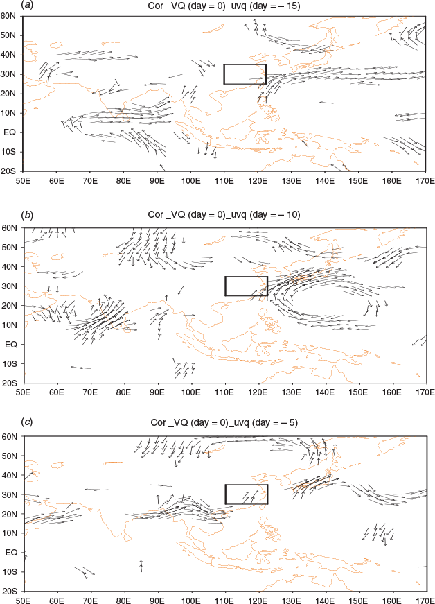
On a submonthly timescale, Fig. 6 further shows such correlations with 5–15 days of lead time (i.e. from day = −15 to day = −5) for the occurrences of heavy rainfall events over the Yangtze Plain. Comparing Fig. 6 with results in Fig. 5, there was a persistent relationship between meridional moisture transport into the Yangtze Plain and IVT over the tropical West Pacific. The WPSH tended to be more northward and more westward according to these correlation maps. Another feature was that, at longer lead time, there were moderate signals over the tropical Indian Ocean and the BoB, with enhanced monsoon westerlies over the BoB and across the Indochina Peninsula. This could have led to more warm and wet air being accumulated in the South China Sea and South China region, which was further transported into the Yangtze River region through strengthened southwesterly flow in association with the development of WPSH. By combining with Fig. 6a and Fig. 5d, we show that the relationship between IVT over the Yangtze Plain and the West Pacific displays a 10–15 day cycle. This is consistent with the biweekly variation of the subtropical summer monsoon rainfall over the Yangtze River (Yang et al. 2010).
4 Performance of ACCESS-S1 in the Yangtze Plain and East China
While our knowledge about the East Asian monsoon and the numerical models used in modelling and forecasting Asian monsoons have made remarkable progress in the last decades, it is still a great challenge to provide skillful rainfall forecasts during the East Asian summer monsoon season (Wang et al. 2009). In Section 3 we showed close connections between the strength and position of WPSH and the moisture transport into the Yangtze River region. We further showed that the ARs influencing the Yangtze Plain summer rainfall can be linked to the position/strength of circulation patterns in the tropical West Pacific 10–15 days in advance. This could mean that there is even more potential predictability of these ARs, as the atmospheric circulations in the tropics are predictable due to their close association with slowly varying tropical sea surface temperature (SST) conditions. Indeed, Wang et al. (2013) suggested that the WPSH, which has long been recognised as having tremendous impact on development and evolution of the East Asian monsoon, can be a potential feature for monsoon rainfall prediction. This is partly because the WPSH is predictable due to its close air–sea feedbacks with tropical oceans in the Indo-Pacific. In this part of the analysis we focused on examining the performance of the current operational seasonal forecast model ACCESS-S1 in the Australian Bureau of Meteorology in forecasting rainfall, circulation and moisture transport anomalies in the East Asian region. This allowed us to assess if ARs can be a useful diagnosis for bridging the gap between model forecasts of dominant circulations in the region and the model rainfall forecasts.
Fig. 7 shows ACCs of 23-year (1990–2012) precipitation hindcasts from ACCESS-S1for May-June-July (MJJ) with the model initial time at 0000 UTC 01 May. There were a couple of reasons why we selected the MJJ season. Firstly, the Meiyu season, which dominates the monsoon rainfall in the Yangtze River Plain, peaks in early June to mid-July. Secondly, a study by Zhao et al. (2019) showed some significant impacts of soil moisture initialisation on ACCESS-S1 forecast skills over Australia. In that study, they conducted a set of 23-year hindcasts for MJJ from the start date of 1 May but with different soil moisture initial conditions. We plan to conduct another study that compares results from our current analysis with the results from the sensitivity study of Zhao et al. (2019) to explore potential impacts of soil moisture initialisation on the model performance in East Asia. Therefore, for this analysis we decided to concentrate on the same period of MJJ, as used in Zhao et al. (2019), to complement our future analysis.

|
In Fig. 7, the lead time zero rainfall hindcasts for May (model initialized at 0000 UTC 1 May to forecast the May averages) showed significant skill over a large part of East China, with ACC up to 0.4 or higher over South China (roughly 20–30°N, 110–125°E) and over part of the North China Plain. However, the skill was relatively lower in the lower reaches of the Yangtze River region. The lead time 0 skill in May likely came from the model atmospheric initial condition. For the hindcasts for June, with a lead time of 1 month, the model skill significantly reduced, with only notable skills over South China and Northeast China. Note that the model skill over the western part of the country was, to some extent, caused by very low rainfall received in these arid regions. Further worsening of the model rainfall forecast skill with a two-month lead time is evident in Fig. 7c. This is not surprising given the fact that such an undesirable performance for forecast with longer lead time is commonly seen in other coupled forecasts, and longer lead time rainfall forecasts in the East Asian monsoon region remain a significant challenge (Wang et al. 2009).
In contrasts, the model did have some skill in forecasting large-scale circulation and its moisture transport over the region. Fig. 8 shows hindcast skills of 850 hPa horizontal moisture transport (Uq and Vq denoting zonal and meridional component respectively) in East Asia for May (0-month lead time), June (1-month lead time) and July (2-month lead time). Significant forecast skill was shown over South China, the South China Sea and the West Pacific in May. Furthermore, the skill exhibited some characteristics of long, southwest–northeast orientation, which was similar to the climatological AR analysis discussed in previous sections. Although the skill reduced with longer lead times, it was mostly retained over part of the East Asian region and showed AR-like features. Such a feature was particularly clear in July and August hindcasts. Another interesting feature was that the model skill in forecasting the 850 hPa moisture transport seemed to propagate along with the East Asian monsoon development. For example, more skillful forecasts were located further towards the inland region and more northward, reaching North China from June to August. The more inland penetration of the model skill in forecasting low-level horizontal moisture transport can be partly understood as the westward extension of the WPSH in the course of the monsoon development. While the more northward expansion of the model skill agreed with the northward migration of the East Asian summer monsoon when the WPSH moved northward, note that results in Fig. 8 are from the model 850 hPa moisture transport using monthly data, so strictly speaking, they are not IVT or AR forecast skills. However, considering the fact that the IVT is largely determined by moisture transport in the lower troposphere and 850 hPa circulation is often reflects low-level monsoon circulations, we expect such skills in Fig. 8 to be a good approximation of the actual model forecast skill of IVTs operating in East Asia. This was also confirmed by results from Mo (2018). In our future study, we plan to use an automatic AR detection scheme and apply it to daily IVT fields in the ACCESS-S1 hindcasts, similar to DeFlorio et al. (2018).

|
In addition to the model skill from the 23-year hindcasts, here we present a case study to demonstrate the model skill during an extremely heavy rainfall season in the Yangtze Plain and South China in the summer of 1998. This historical event, which caused thousands of fatalities and tremendous social and economic impacts, has drawn significant research (e.g. Chen et al. 2001; Zhang et al. 2001; Ding and Hu 2003), some of which emphasized the persistent strong moisture transport into the region as the chief cause of this disastrous event. Fig. 9 compares observed and hindcasted rainfall anomalies in that summer season. Overall, the model successfully forecasted a wet summer over a large part of East China and the North China Plain. However, the model forecasts missed the observed severe floods in the upper and middle reaches of the Yangtze River region, and the model failed to forecast severe floods in Northeast China. Further examination (not shown) of the model forecast skill for MJJ also suggests that the model skill was largely from the forecasts for May and June, with poor skill in July.

|
We now examine the low-level moisture transport for this severe flooding season. As shown in Fig. 10, there was strong southwest–northeastward moisture transport from Indochina Peninsula and nearby warm waters penetrating South China and reaching the Yangtze Plain. This was particularly evident in June–July. Comparing results in Fig. 10 with the mean climatology derived from ERA-Interim data for 1979–2016, also showed that such a moisture transport channel was much stronger than its climatology. Prior to the flood period in June–July, an anomalous anticyclonic pattern already presented over the tropical and Northwest Pacific. This resulted in enhanced onshore moisture transport toward East China. When the WPSH strengthened and moved more northward, an anomalously strong moisture transport belt extended from the South China Sea to the northwest and sustainably impacted the Yangtze Plain with extremely heavy precipitation. Such a feature was persistent through June–July and acted to steadily supply abundant warm and moist air into the Yangtze Plain and cause severe floods there. As aforementioned, although results in Fig. 10 are only based on 850 hPa data, they gave a good indication that AR-like moisture transport in this season was very likely to be particularly strong.

|
The above mentioned strong horizontal moisture transports that contributed to severe flooding in the Yangtze River region were reasonably hindcasted by ACCESS-S1. As shown in Fig. 11, the anomalously enhanced meridional transport at 850 hPa from the tropical West Pacific in May was successfully forecasted by ACCESS-S1. The model even over predicted an enhanced inland southwest–northeast moisture transport over Southeast China. The model’s skill in capturing the moisture transport anomalies in June and July was particularly promising, with consistent anomaly patterns and intensities comparable with the observed pattern. The overall results demonstrated that the model made very skillful forecasts of very strong moisture transport anomalies into the East China region, although the model did have a systematic bias by underestimating the averaged strength of inland penetration of moisture from the tropics into the East Asian continent. Such a lack of monsoon northeastward penetration in the East Asia region is a well-known feature in global models (e.g. Zhang et al. 2012; Dong et al. 2016). Considering these 850 hPa moisture transport patterns and anomalies have AR-like shapes, we expected the model to have some reasonable skill in forecasting AR activities during this season. This will be a key task of our future project as previously discussed. Therefore, as suggested by Wang et al. (2013), one can expect some rainfall forecasting skill gain by linking the model skill in forecast atmospheric circulations and its moisture transport (i.e. ARs) with its rainfall forecast.

|
5 Summary and discussions
In this paper, motivated by a lack of understanding of the connection between atmospheric rivers (ARs) (Newell et al. 1992; Zhu and Reginald 1994) and floods over the East Asian monsoon region, we investigated the association of heavy rainfall events over the Yangtze Plain in East China with atmospheric moisture transport and ARs during the boreal summer. We also further assessed the forecast potential of ARs on subseasonal and seasonal timescales by evaluating a set of hindcasts from the current operational coupled seasonal forecast model, ACCESS-S1, from the Australian Bureau of Meteorology (Hudson et al. 2017, 2018; Zhao et al. 2019).
During the whole boreal summer (JJAS), three strong seasonal-mean IVT branches impacted rainfall over the Yangtze Plain. One came from the Indian Ocean and BoB region, which can be considered a climatological AR associated with the South Asian monsoon and Somali cross-equatorial flow. The other two branches originated from the South China Sea by both the cross-equatorial flow from North Australia to East Asia and the subtropical anticyclonic flow along the south and west of the WPSH. The latter two climatological IVT belts could not be called climatological ARs as their shapes did not satisfy the criteria of ARs as used in other studies (Guan and Waliser 2015; Ye et al. 2020). During June and July, there was a climatological East Asian AR influencing the Yangtze Plain, which corresponded to a strong IVT off East Asian Meiyu with strong seasonal cycle and intraseasonal oscillation.
We also examined the composite features of moisture transport for large-scale persistent heavy rainfall events over the Yangtze Plain. These events had rainfall intensity more than double their climatological average during the whole summer, and they generally corresponded to rainstorms with cumulative precipitation of more than 50 mm and even 100 mm during their life cycles. Compared with summer IVT climatology, the East Asian ARs exhibited distinct features responsible for heavy rainfall occurrence in the region. The IVT over the west of WPSH moved northward towards the south Yangtze Plain via the South China Sea, and the IVT from the cross-equatorial flow from north of Australia strengthened over the Indochina Peninsula and weakened over the west of the Philippines. These anomalous moisture transports encountered anomalous cold air from Northeast Asia and caused severe rainfall over the Yangtze Plain. Thus, ARs leading to heavy rainfall over the Yangtze Plain were connected with the intrusion of cold air from the north. This is different from the mechanisms identified in some parts of the world where ARs encountering mountains lead to extreme rainfall generation (Ralph et al. 2006; Neiman et al. 2011). On a subseasonal timescale, we further showed that the relationship between the ARs over the Yangtze Plain and IVT over the West Pacific can be maintained for up to about 15 days.
In addition, we evaluated subseasonal and seasonal forecasts of heavy rainfall and their related horizontal moisture transport from the ACCESS-S1 (Hudson et al. 2017; Zhao et al. 2019). Results suggested that the model can produce more skillful forecasts of IVTs than rainfall. The model IVT skill showed some AR-like spatial patterns, suggesting that the model could be skillful in forecasting ARs during the Meiyu season. Such a conclusion has been further supported by a case study of an extremely heavy flooding summer season in 1998 over the Yangtze Plain. For this case, the model successfully forecasted persistent and strong moisture transport anomalies into South China and the Yangtze River region. The skill in forecasting such anomalies was higher than its rainfall forecasts. The overall results suggest that skillful subseasonal and seasonal forecasts of ARs may provide potential for subseasonal forecasting of extreme rainfall over the Yangtze Plain. However, calibration or reducing the model’s systematic error of underestimating IVT over both the tropic oceans and inland regions are crucial for future development and improvement of forecast skill. Our results support the study of Wang et al. (2013), which highlighted the potential of using WPSH as the pathway for improving rainfall seasonal and subseasonal forecasts in East Asia. Our analysis went one step further by suggesting that if we can capitalise the model skill in forecasting ARs that are closely influenced by the position and strength of the WPSH, then we can potentially improve the rainfall forecast skill over the East Asian region, which is strongly affected by AR activities.
However, there were a number of significant weaknesses in this study. Firstly, we only looked at the climatologies of IVTs in the East Asian region and termed them as climatological ARs. However, East Asian monsoons and rainfall in the Yangtze River region also experience significant interannual variations (ref. Wang 2006; Day et al. 2018). There were even ‘empty Meiyu’ years when only minimal rainfall occurred in the region. It is unclear whether these cases were associated with anomalous AR activities. To address this issue, we need to examine the year-to-year variations. Although in the current collaborative AR project Wu et al. (2020) produced a manual detected AR dataset, there is a lack of in-depth analysis of ARs and rainfall interannual variations in the Yangtze River region. We plan to develop our own AR automatic detection scheme that is more applicable in the East Asian region and then revise our results obtained in this study based on the resulting AR dataset. Secondly, in the model assessment, we only analysed monthly model results at a single level. We plan to conduct a thorough assessment by applying an automatic AR detection scheme to daily IVT fields in the ACCESS-S1 hindcasts and explore the model skills in forecasting ARs at intraseasonal and seasonal timescales. Furthermore, in this study, we underlined the importance of WPSH in influencing the moisture transport into the East Asian monsoon region; but there are a number of important drivers, such as Madden and Julian Oscillation (Madden and Julian 1972), El-Niño Southern Oscillation (Trenberth 1997) and the Indian Ocean SST anomalies, which can also influence WPSH, moisture transport and ARs in the East Asian region (Lu et al. 2018). Our current analysis only serves as a background analysis, and it has shown the potential of using ARs for better understanding the climate in the East Asian region and improving our forecast skill.
Conflicts of interest
The authors declare that they have no conflicts of interest.
Acknowledgments
This research was jointly supported by the National Key Research and Development Plan ‘Major Natural Disaster Monitoring, Warning and Prevention’ of China (2017YFC1502301), the National Natural Science Foundation of China (41790471;41775047), National Key R&D Program of China (2017YFE0133600), and Social Development Projects of STCSM (19DZ1201500). It was conducted under the bilateral, collaborative atmospheric river project between the Australian Bureau of Meteorology and the China Meteorological Administration as well as the National Meteorological Science and technology innovation project (subseasonal to seasonal prediction and climate system model) of China. We appreciate the agreement from the ACCESS-S1 development team for sharing the hindcast data used in this analysis. We thank Drs Li Shi and William Wang for their comments/suggestions during the internal review process.
References
Boos, W. R., and Kuang, Z. (2010). Dominant control of the South Asian monsoon by orographic insulation versus plateau heating. Nature 463, 218–222.| Dominant control of the South Asian monsoon by orographic insulation versus plateau heating.Crossref | GoogleScholarGoogle Scholar | 20075917PubMed |
Chen, L., Zhu, C., and Wang, W. (2001). Analysis of the characteristics of 30-60 day low-frequency oscillation over Asia during 1998 SCSMEX. Adv. Atmos. Sci. 18, 623–638.
| Analysis of the characteristics of 30-60 day low-frequency oscillation over Asia during 1998 SCSMEX.Crossref | GoogleScholarGoogle Scholar |
Chen, J., Zhang, H., Ye, C., Chen, H., and Mo, R. (2020). Case studies of atmospheric rivers over China and Australia: new insight into their rainfall generation. J. South. Hemisph. Earth Syst. Sci. , .
| Case studies of atmospheric rivers over China and Australia: new insight into their rainfall generation.Crossref | GoogleScholarGoogle Scholar |
Day, J. A., Fung, I., and Liu, W. (2018). Changing character of rainfall in eastern China: 1951–2007. PNAS 115, 2016–2021.
| Changing character of rainfall in eastern China: 1951–2007.Crossref | GoogleScholarGoogle Scholar | 29440414PubMed |
Dee, D. P., Uppala, S. M., Simmons, A. J., et al. (2011). The ERA-Interim reanalysis: conzuration and performance of the data assimilation system. Quart. J. Roy. Meteor. Soc. 137, 553–597.
| The ERA-Interim reanalysis: conzuration and performance of the data assimilation system.Crossref | GoogleScholarGoogle Scholar |
DeFlorio, M., Waliser, D., Guan, B., Lavers, D., Ralph, F., and Vitart, F. (2018). Global assessment of atmospheric river prediction skill. J. Hydrometeor. 19, 409–426.
| Global assessment of atmospheric river prediction skill.Crossref | GoogleScholarGoogle Scholar |
Dettinger, M. (2011). Climate change, atmospheric rivers, and floods in California-A multimodel analysis of storm frequency and magnitude changes. J. Am. Water Res. Assoc. 47, 514–523.
| Climate change, atmospheric rivers, and floods in California-A multimodel analysis of storm frequency and magnitude changes.Crossref | GoogleScholarGoogle Scholar |
Ding, Y. (1994). Monsoons over China. (Kluwer Academic Publisher: Dordrecht.), 419pp.
Ding, Y., and Hu, G. (2003). A study on water vapor budget during the 1998 severe flood periods. Acta Meteorol. Sin. 61, 129–145.
Ding, Y., and Sun, Y. (2001). A study on anomalous activities of East Asian summer monsoon during 1999. J. Meteor. Soc. Japan. Ser. II 79, 1119–1137.
| A study on anomalous activities of East Asian summer monsoon during 1999.Crossref | GoogleScholarGoogle Scholar |
Dong, G., Zhang, H., Moise, A., Hanson, L., Liang, P., and Ye, H. (2016). CMIP5 model-simulated onset, duration and intensity of the Asian summer monsoon in current and future climate. Climate Dyn. 46, 355–382.
| CMIP5 model-simulated onset, duration and intensity of the Asian summer monsoon in current and future climate.Crossref | GoogleScholarGoogle Scholar |
Grossmann, A., and Morlet, J. (1984). Decomposition of Hardy functions into square integrable wavelets of constant shape. SIAM J. Math. Anal. 15, 723–736.
| Decomposition of Hardy functions into square integrable wavelets of constant shape.Crossref | GoogleScholarGoogle Scholar |
Guan, B., and Waliser, D. E. (2015). Detection of atmospheric rivers: Evaluation and application of an algorithm for global studies. J. Geophys. Res. Atmos. 120, 12514–12535.
| Detection of atmospheric rivers: Evaluation and application of an algorithm for global studies.Crossref | GoogleScholarGoogle Scholar |
He, J., and Zhu, Z. (2015). The relation of South China Sea monsoon onset with the subsequent rainfall over the subtropical East Asia. Int. J. Climatol. 35, 4547–4556.
| The relation of South China Sea monsoon onset with the subsequent rainfall over the subtropical East Asia.Crossref | GoogleScholarGoogle Scholar |
Higgins, R. W., Schemm, J.-K. E., Shi, W., and Leetmaa, A. (2000). Extreme precipitation events in the western United States related to tropical forcing. J. Climate 13, 793–820.
| Extreme precipitation events in the western United States related to tropical forcing.Crossref | GoogleScholarGoogle Scholar |
Huang, Y., Wang, H., and Fan, K. (2014). Improving the prediction of the Summer Asian–Pacific Oscillation using the interannual increment approach. J. Climate 27, 8126–8134.
| Improving the prediction of the Summer Asian–Pacific Oscillation using the interannual increment approach.Crossref | GoogleScholarGoogle Scholar |
Hudson, D., Shi, L., Alves, O., Zhao, M., Hendon, H., Yong, G. (2017). Performance of ACCESS-S1 for key horticultural regions. Bureau Research Report, No. 20. Bureau of Meteorology, Australia.
Hudson, D., Alves, O., Hendon, H. H., et al. (2018). ACCESS-S1: The new Bureau of Meteorology multi-week to seasonal prediction system. J. South. Hemisph. Earth Syst. Sci. 67, 132–159.
| ACCESS-S1: The new Bureau of Meteorology multi-week to seasonal prediction system.Crossref | GoogleScholarGoogle Scholar |
IPCC. (2013). Climate Change 2013: The Physical Science Basis. Working Group I Contribution to the Fifth Assessment Report of the Intergovernmental Panel on Climate Change. (Eds T. F. Stocker, D. Qin, G.-K. Plattner, M. Tignor, S.K. Allen, J. Boschung, A. Nauels, Y. Xia, V. Bex and P. M. Midgley.) Cambridge University Press: Cambridge. 1535pp
Kalnay, E., Kanamitsu, M., Kistler, R., Collins, W., Deaven, D., Gandin, L., Iredell, M., Saha, S., White, G., Woollen, J., Zhu, Y., Leetmaa, A., Reynolds, R., Chelliah, M., Ebisuzaki, W., Higgins, W., Janowiak, J., Mo, K. C., Ropelewski, C., Wang, J., Jenne, R., and Joseph, D. (1996). The NCEP/NCAR 40-year reanalysis project. Bull. Amer. Meteor. Soc. 77, 437–471.
| The NCEP/NCAR 40-year reanalysis project.Crossref | GoogleScholarGoogle Scholar |
Krishnamurti, T. N., and Gadgil, S. (1985). On the structure of the 30 to 50 day mode over the globe during FGGE. Tellus. Series A 37A, 336–360.
| On the structure of the 30 to 50 day mode over the globe during FGGE.Crossref | GoogleScholarGoogle Scholar |
Lavers, D. A., Allan, R. P., Wood, E. F., Villarini, G., Brayshaw, D. J., and Wade, A. J. (2011). Winter floods in Britain are connected to atmospheric rivers. Geophys. Res. Lett. 38, L23803.
| Winter floods in Britain are connected to atmospheric rivers.Crossref | GoogleScholarGoogle Scholar |
Liang, P., Li, W., Chen, L., and Ren, Z. (2005). Features and sources of the anomalous moisture transport for the severe summer rainfall over the upper reaches of the Yangtze River. J. Meteor. Res. 19, 202–215.
Liang, P., and Ding, Y. (2017). The long-term variation of extreme heavy precipitation and its link to urbanization effects in Shanghai during 1916–2014. Adv. Atmos. Sci. 34, 321–334.
| The long-term variation of extreme heavy precipitation and its link to urbanization effects in Shanghai during 1916–2014.Crossref | GoogleScholarGoogle Scholar |
Liebmann, B., and Smith, C. A. (1996). Description of a complete (interpolated) outgoing longwave radiation dataset. Bull. Amer. Meteor. Soc. 77, 1275–1277.
Lu, B., Ren, H. L., Eade, R., and Andrews, M. (2018). Indian Ocean SST modes and their impacts as simulated in BCC_CSM1.1(m) and HadGEM3. Adv. Atmos. Sci. 35, 1035–1048.
| Indian Ocean SST modes and their impacts as simulated in BCC_CSM1.1(m) and HadGEM3.Crossref | GoogleScholarGoogle Scholar |
MacLachlan, C., Arribas, A., Peterson, K. A., et al. (2015). Global Seasonal forecast system version 5 (GloSea5): a high-resolution seasonal forecast system. Quart. J. Roy. Meteor. Soc. 141, 1072–1084.
| Global Seasonal forecast system version 5 (GloSea5): a high-resolution seasonal forecast system.Crossref | GoogleScholarGoogle Scholar |
Madden, R. A., and Julian, P. R. (1972). Description of global-scale circulation cells in the tropics with a 40–50 day period. J. Atmos. Sci. 29, 1109–1123.
| Description of global-scale circulation cells in the tropics with a 40–50 day period.Crossref | GoogleScholarGoogle Scholar |
Mo, R. (2018). Application of Atmospheric River in Operational Rainfall Forecasts in Canada/North America. Science to Services Seminar. Bureau of Meteorology 01 Feb 2018, Melbourne, Australia.
Neiman, P. J., Schick, L. J., Ralph, F. M., Hughes, M., and Wick, G. A. (2011). Flooding in western Washington: The connection to atmospheric rivers. J. Hydrometeor. 12, 1337–1358.
| Flooding in western Washington: The connection to atmospheric rivers.Crossref | GoogleScholarGoogle Scholar |
Neiman, P. J., White, A. B., Ralph, F. M., Gottas, D. J., and Gutman, S. I. (2009). A water vapour flux tool for precipitation forecasting. Water Manage. 162, 83–94.
| A water vapour flux tool for precipitation forecasting.Crossref | GoogleScholarGoogle Scholar |
Newell, R. E., Newell, N. E., Zhu, Y., et al. (1992). Tropospheric rivers-A pilot study. Geophys. Res. Lett. 12, 2401–2404.
| Tropospheric rivers-A pilot study.Crossref | GoogleScholarGoogle Scholar |
Ralph, F. M., Dettinger, M., Lavers, D., et al. (2017). Atmospheric rivers emerge as a global science and applications focus. Bull. Amer. Meteor. Soc. 98, 1969–1973.
| Atmospheric rivers emerge as a global science and applications focus.Crossref | GoogleScholarGoogle Scholar |
Ralph, F. M., Neiman, P. J., Wick, G. A., Gutman, S. I., Dettinger, M. D., Cayan, D. R., and White, A. B. (2006). Flooding on California’s Russian River: Role of atmospheric rivers. Geophys. Res. Lett. 33, L13801.
| Flooding on California’s Russian River: Role of atmospheric rivers.Crossref | GoogleScholarGoogle Scholar |
Simmonds, I., Bi, D., and Hope, P. (1999). Atmosphere water vapor flux and its association with rainfall over China in summer. J. Climate 12, 1353–1367.
Tao, S., and Chen, L. (1987). A review of recent research on East Asian summer monsoon in China. In ‘Monsoon Meteorology’. (Eds. C. P. Chang and T. N. Krishnamurti.) pp. 60–92. (Oxford University Press).
Trenberth, K. E. (1997). The definition of El Nino. Bull. Amer. Meteor. Soc. 78, 2771–2777.
| The definition of El Nino.Crossref | GoogleScholarGoogle Scholar |
Trenberth, K. (2005). Uncertainty in hurricanes and global warming. Science 308, 1753–1754.
| Uncertainty in hurricanes and global warming.Crossref | GoogleScholarGoogle Scholar | 15961661PubMed |
Viale, M., and Nunez, M. N. (2011). Climatology of winter orographic precipitation over the subtropical central Andes and associated synoptic and regional characteristics. J. Hydrometeor. 12, 481–507.
| Climatology of winter orographic precipitation over the subtropical central Andes and associated synoptic and regional characteristics.Crossref | GoogleScholarGoogle Scholar |
Wang, B. (2006). The Asian Monsoon. (Springer: Heidelberg, Germany.) 787pp.
Wang, B., Lee, J. Y., Kang, I. S., Shukla, J., et al. (2009). Advance and prospectus of seasonal prediction: Assessment of APCC/CliPAS 14-model ensemble retrospective seasonal prediction (1980–2004). Climate Dyn. 33, 93–117.
| Advance and prospectus of seasonal prediction: Assessment of APCC/CliPAS 14-model ensemble retrospective seasonal prediction (1980–2004).Crossref | GoogleScholarGoogle Scholar |
Wang, B., Xiang, B., and Lee, J.-Y. (2013). Subtropical High predictability establishes a promising way for monsoon and tropical storm predictions. PNAS 110, 2718–2722.
| Subtropical High predictability establishes a promising way for monsoon and tropical storm predictions.Crossref | GoogleScholarGoogle Scholar | 23341624PubMed |
Wang, B., and Xu, X. H. (1997). Northern Hemisphere summer monsoon singularities and climatological intraseasonal oscillation. J. Climate 10, 1071–1085.
| Northern Hemisphere summer monsoon singularities and climatological intraseasonal oscillation.Crossref | GoogleScholarGoogle Scholar |
Wang, Y., and Zhou, L. (2005). Observed trends in extreme precipitation events in China during 1961–2001 and the associated changes in large-scale circulation. Geophys. Res. Lett. 32, L09707.
| Observed trends in extreme precipitation events in China during 1961–2001 and the associated changes in large-scale circulation.Crossref | GoogleScholarGoogle Scholar |
Wang, Y., and Zhou, L. (2005). Correction to observed trends in extreme precipitation events in China during 1961–2001 and the associated changes in large‐scale circulation. Geophys. Res. Lett. 32, L09707.
| Correction to observed trends in extreme precipitation events in China during 1961–2001 and the associated changes in large‐scale circulation.Crossref | GoogleScholarGoogle Scholar |
Wick, G., Neiman, P. J., and Ralph, F. M. (2013). Description and validation of an automated objective technique for identification and characterization of the integrated water vapor signature of atmospheric rivers. IEEE Trans. Geosci. Remote Sens. 51, 2166–2176.
| Description and validation of an automated objective technique for identification and characterization of the integrated water vapor signature of atmospheric rivers.Crossref | GoogleScholarGoogle Scholar |
Williams, K. D., Harris, C. M., Bodas-Salcedo, A., et al. (2015). The Met Office Global Coupled model 2.0 (GC2) configuration. Geosci. Model Dev. 8, 1509–1524.
| The Met Office Global Coupled model 2.0 (GC2) configuration.Crossref | GoogleScholarGoogle Scholar |
Wu, J., and Gao, X. (2013). A gridded daily observation dataset over China region and comparison with the other datasets. Chin. J. Geophys. 56, 1102–1111.
Wu, Z. and Huang, N. E. (2005). Ensemble empirical mode decomposition: A noise-assisted data analysis method. COLA Tech. Rep. No.193, Center for Ocean-Land-Atmos. Studies, Calverton, Maryland.
Wu, Z., and Huang, N. E. (2009). Ensemble empirical mode decomposition: A noise-assisted data analysis method. Adv. Adapt. Data Anal. 1, 1–41.
| Ensemble empirical mode decomposition: A noise-assisted data analysis method.Crossref | GoogleScholarGoogle Scholar |
Wu, X.-Y., Ye, C., He, W., Chen, J., Xu, L., and Zhang, H. (2020). Atmospheric rivers impacting mainland China and Australia: climatology and interannual variations. J. South. Hemisph. Earth Syst. Sci , .
| Atmospheric rivers impacting mainland China and Australia: climatology and interannual variations.Crossref | GoogleScholarGoogle Scholar |
Yang, J., Wang, B., and Bao, Q. (2010). Biweekly and 21–30-day variations of the subtropical summer monsoon rainfall over the lower reach of the Yangtze River Basin. J. Climate 23, 1146–1159.
| Biweekly and 21–30-day variations of the subtropical summer monsoon rainfall over the lower reach of the Yangtze River Basin.Crossref | GoogleScholarGoogle Scholar |
Wu, G., Liu, Y., He, B., Bao, Q., Duan, A., and Jin, F. (2012). Thermal controls on the Asian summer monsoon. Sci. Rep. 2, 404.
| Thermal controls on the Asian summer monsoon.Crossref | GoogleScholarGoogle Scholar | 22582141PubMed |
Ye, C., Zhang, H., Moise, A., and Mo, R. (2020). Atmospheric rivers in the Australia-Asian region: a BoM–CMA collaborative study. J. South. Hemisph. Earth Syst. Sci. , .
| Atmospheric rivers in the Australia-Asian region: a BoM–CMA collaborative study.Crossref | GoogleScholarGoogle Scholar |
Yin, S., Li, W., Chen, D., Jeong, J. H., and Guo, W. (2011). Diurnal variations of summer precipitation in the Beijing area and the possible effect of topography and urbanization. Adv. Atmos. Sci. 28, 725–734.
| Diurnal variations of summer precipitation in the Beijing area and the possible effect of topography and urbanization.Crossref | GoogleScholarGoogle Scholar |
Zhang, R. (2001). Relation of water vapor transport from Indian Monsoon with that over East Asia and the summer rainfall in China. Adv. Atmos. Sci. 18, 1005–1017.
| Relation of water vapor transport from Indian Monsoon with that over East Asia and the summer rainfall in China.Crossref | GoogleScholarGoogle Scholar |
Zhang, H., Liang, P., and Moise, A. (2012). Diagnosing potential changes in Asian summer monsoon onset and duration in IPCC AR4 model simulations using moisture and wind indices. Climate Dyn. 39, 2465–2486.
| Diagnosing potential changes in Asian summer monsoon onset and duration in IPCC AR4 model simulations using moisture and wind indices.Crossref | GoogleScholarGoogle Scholar |
Zhang, S., Tao, S., Zhang, Q., and Zhang, X. (2001). Meteorological and Hydrological Characteristics of Severe Flooding in China During the Summer of 1998. J. Appl. Meteor. Sci. 12, 442–457.
Zhao, M., Zhang, H., and Dharssi, I. (2019). On the soil moisture memory and influence on coupled seasonal forecasts over Australia. Climate Dyn. 52, 7085–7109.
| On the soil moisture memory and influence on coupled seasonal forecasts over Australia.Crossref | GoogleScholarGoogle Scholar |
Zhu, Z., and Li, T. (2016). A new paradigm for continental U.S. summer rainfall variability: Asia–North America teleconnection. J. Climate 29, 7313–7327.
| A new paradigm for continental U.S. summer rainfall variability: Asia–North America teleconnection.Crossref | GoogleScholarGoogle Scholar |
Zhu, Y., and Reginald, E. N. (1994). Atmospheric rivers and bombs. Geophys. Res. Lett. 21, 1999–002.
| Atmospheric rivers and bombs.Crossref | GoogleScholarGoogle Scholar |
Zhu, Z., Li, T., and He, J. (2014). Out-of-phase relationship between boreal spring and summer decadal rainfall changes in southern China. J. Climate 27, 1083–1099.
| Out-of-phase relationship between boreal spring and summer decadal rainfall changes in southern China.Crossref | GoogleScholarGoogle Scholar |