
Extraordinary sequence of severe weather events in the late-nineteenth century
Jeff CallaghanA Retired. Bureau of Meteorology, Brisbane, Qld., Australia. Postal address: 3/34 Macalister Road, Tweed Heads, NSW 2486, Australia. Email: jeffjcallaghan@gmail.com
Journal of Southern Hemisphere Earth Systems Science 70(1) 252-279 https://doi.org/10.1071/ES19041
Submitted: 3 June 2019 Accepted: 6 July 2020 Published: 5 October 2020
Journal Compilation © BoM 2020 Open Access CC BY-NC-ND
Abstract
Between 1883 and 1898, 24 intense tropical cyclones and extra tropical cyclones directly impacted on the southern Queensland and northern New South Wales coasts, with at least 200 fatalities in what was then a sparsely populated area. These events also caused record floods and rainfall, for example Brisbane City experienced its two largest ever floods over this period and Brisbane City set a 24-h rainfall record that still stands today. Additionally, a 24-h rainfall total of 907 mm occurred in a tributary of the upper Brisbane River resulting in a 15-m wall of water advancing down the river. Recent studies have shown that this part of Australia incurs the largest weather-related insurance losses. A major focus in this study is the seas these storms generated, leading to the loss of many marine craft and changes these waves brought to coastal areas. As a famous example of coastal erosion near Brisbane, the continual impacts from large waves caused a channel to form through Stradbroke Island to the open ocean forming two separate islands. Details of how this channel formed are described in relation to the storms. A climatology study of 239 Australian east coast storms that caused severe ocean damage between Brisbane and the Victorian border over the period between 1876 and February 2020 showed that 153 events occurred with a positive Southern Oscillation Index (SOI) trend and 86 events with a negative trend. The most active years were 1893 and 1967, both during positive SOI periods and both dominated by tropical cyclone activity. The 1893 events caused unparalleled floods and strongly contributed to the Jumpinpin breakthrough on Stradbroke Island, and the 1967 event was associated with historical Gold Coast beach erosion causing 9 billion normalised Australian dollars of insurance losses. The study also showed how direct tropical cyclone impacts in the study area decreased markedly following the June 1976 climate shift.
Keywords: coastal erosion, floods, late-nineteenth century, record rainfall, severe weather, southern oscillation, storm surge, tropical cyclones.
1 Introduction
Despite the lack of a severe impact in Southeast Queensland (SEQ) or northeast New South Wales (NSW) from a tropical cyclone (TC) in recent decades, McAneney et al. (2019) showed that this region is subject to some of the worst insurance losses from TCs and related systems in the Australian region. For example, their study of normalised insurance losses for 1966–2017 showed that TC Dinah in January 1967 came in third with 4685 million normalised Australian dollars (AU$), TC Wanda in January 1974 fifth with AU$3160 million, the Brisbane hail storm of 18 January 1985 was seventh with AU$2274 million and a tropical low which crossed the coast in January 2011 came in eighth with AU$2260 million with a brief resumption of sustained activity. These four systems mainly impacted SEQ, and TC Dinah never actually made landfall on the mainland but came close, crossing Fraser Island where a central pressure of 944.8 hPa was read. This region’s population grew dramatically from 1977 onwards as the above study shows. Some of the worst impacts in this region occurred during the latter part of the nineteenth century. Most of this region was only sparsely populated in the nineteenth century and if such a sequence of events occurred today the results would be catastrophic.
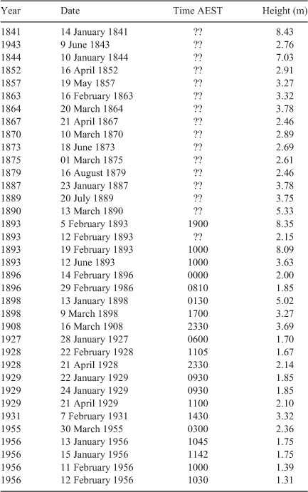
The Bureau of Meteorology’s TC data base begins in 1908. Earlier TCs have been described in Brunt (1958); Callaghan and Helman (2008); Callaghan and Power (2014, 2011); Hunt (1914); Visher and Hodge (1925) and Watt (1940). An unusually aggressive and destructive series of weather systems impacted on Australia’s subtropical east coast between 1883 and 1898. Two of the biggest floods in Brisbane’s history, 8.35 m on 5 February 1893 and 8.09 m on 19 February 1893, occurred during this period. The largest recorded flood in Brisbane was 8.43 m on 14 January 1841. However, there was a bar at the mouth of the Brisbane River in 1841 which is thought to have added 0.4 m to the flood and the Brisbane City Council has reduced the 1841 flood level to 8.03 m, making the two 1893 floods the biggest in recorded history. Other major floods occurred in Brisbane during January 1887, July 1889, March 1890 and June 1893. Six major floods struck Brisbane in seven years. Here we examine the meteorology of these floods, particularly in 1893 when six severe weather events produced three major floods, one moderate flood and one heavy rainfall event. Another major flood struck Brisbane on 13 January 1898 – to put this into perspective, only one major Brisbane flood event occurred after this until the 1950s when large dams became operational. Table 1 shows the Brisbane City flood heights for 1841–1956.
|
Brisbane City recorded 465.1 mm in the 24 h ending 2300UTC 21 January 1887, which still stands as a 24-h rainfall record 132 years later. Crohamhurst (26.8°S, 152.9°E, 200.0 m elevation) recorded 907.0 mm in the 24 h to 2300UTC 2 January 1893 (Newman 1958). This was an Australian record until Bellenden Ker (40 km SSE of Cairns, elevation 1545.0 m) recorded 1947.0 mm in the 48 h to 2300UUTC 4 January 1979 during TC Peter.
Floods from these 19th century storms claimed many lives and the large seas generated by their violent winds wrecked many ships, claiming many more lives, with combined totals possibly reaching as much as 200 over the period. The Supplementary Material accompanying Callaghan and Power (2014) also contains reports of severe wave and storm surge damage, and a list derived from this data for 1816–2020 is provided in Appendix 1.
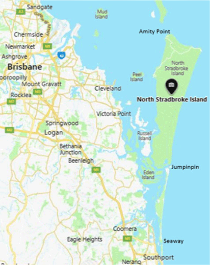
Here we look at the effect of these seas on the coastal environment, and as a measure we monitor the effect on Stradbroke Island where a channel was cut by huge seas from the ocean at a place called Jumpinpin to the sheltered waters south of Moreton Bay. Brisbane lies on the western shores of Moreton Bay (Fig. 1). According to McCauley and Tomlinson (2006), Jumpinpin opened sometime late in the 19th century, breaching over a narrow section of the then Isle of Stradbroke. The exact date of breaching is unknown due to the isolation of the site. Since its formation, the inlet and nearby coastline have been highly dynamic, undergoing rapid and significant changes. The channel formed two islands, North Stradbroke Island, 38 km long and up to 11 km wide, the second largest sand island in the world and the smaller South Stradbroke Island 21 km by 2.5 km. The effect of storm surges and wave action is monitored primarily from reports at Southport which is 73 km south southeast of Brisbane and 27 km south of Jumpinpin and the Moreton Bay suburb of Sandgate which is 16 km north northeast from Brisbane and 60 km north northwest of Jumpinpin. Sandgate is sheltered from the ocean waves by North Stradbroke Island and Moreton Island. Southport in the late-nineteenth century was located on a lagoon (Broadwater) around 800-m wide with ocean waves breaking on its eastern edge. Wave action at Southport then was from reformed ocean waves moving westward across the lagoon or Broadwater.
|
A spit began to extend northwards east of Southport after these 19th century storms and today extends northward to South Stradbroke Island, being 200–400 m wide and 5–10 m in elevation. The average linear growth of the spit from 1910 to 1968 was 61 m per year or 6 km/century (Delft Hydraulics 1970). The supply of sand for this spit can be explained by ocean currents. The East Australian Current is a western boundary current that moves down the east coast of Australia, transporting warm water from the Coral Sea southwards. The meandering current pinches off eddies and the current speeds at the edge of these eddies can be up to 4 knots. Inshore there is a current in a northward direction, which is largely generated by wave action. This was found from the Delft Hydraulics (1970) report in their investigation into the disastrous beach erosion on the Gold Coast in 1967. In 1967, five TCs beginning with severe TC Dinah (Category 4) and then three June East Coast Lows (ECLs) produced unprecedented erosion on the Gold Coast (McCauley and Tomlinson 2006). The results from the Delft Hydraulics (1970) report showed that the littoral transport was mainly directed northwards, and this transport extended seawards out to about 900 m from the shore. South of the Tweed River, near the Gold Coast southern border, the net northward transport was calculated as 500 000 m3 per year, which is of the same order as the sediment supply of the nearest NSW rivers. To gain some idea of the power of ocean waves and storm surge, the 1967 storms removed 8 million m3 of sand from Gold Coast beaches. These storms incurred a total normalised insurance loss of more than AU$9 billion (McAneney et al. 2019).
The paper is organised as follows. Section 2 records the data sources. Section 3 describes the 1893 events as well as all the Brisbane City floods and provides details of the meteorology involved. The effect of weather systems on the coastal areas of Stradbroke Island is examined in Section 4, followed in Section 5 by descriptions of weather systems additional to those in Section 3 which caused ocean damage to the east coast of Stradbroke Island. A climatology of weather systems causing ocean damage along the east coast south from Brisbane is introduced in Section 6 and further severe weather systems occurring between 1853 and 1898 over SEQ without major ocean damage follow in Section 7. A conclusion is reached in Section 8.
2 Data
Impacts and details of the weather systems were obtained from Callaghan and Helman (2008) and Callaghan and Power (2014, 2011). Weather observations and impacts were extracted from newspaper archives of the National Library of Australia (https://trove.nla.gov.au/newspaper/) to augment these reports. Mean sea level weather charts were also constructed manually (using nearly 50 years of experience in such an activity) from data held in the Australian National Archives before that organisation unfortunately removed weather data from their records in the 1990s. The Sir Charles Todd’s weather folio from the late-nineteenth century was extremely useful for constructing weather charts for the late-nineteenth century period (http://www.charlestodd.net/Todd_Folios/). The US 20th Century Reanalyses (https://psl.noaa.gov/data/gridded/data.20thC_ReanV2.html) often showed reasonable agreement with these charts and helped with the construction of charts. Support for the Twentieth Century Reanalysis Project dataset is provided by the U.S. Department of Energy, Office of Science Innovative and Novel Computational Impact on Theory and Experiment (DOE INCITE) program and Office of Biological and Environmental Research (BER), by the National Oceanic and Atmospheric Administration (NOAA) Climate Program Office, by the National Oceanic and Atmospheric Administration Climate Program Office, and by the NOAA Earth System Research Laboratory Physical Sciences Division. Early storm surge data for the Brisbane Roadstead was obtained from Gourlay (1981) and this was also augmented from newspaper reports. Rainfall and flooding data were obtained from Bureau of Meteorology archives and online data.
The initial impetus for this study came from Hunt (1914), in which nineteenth-century TCs and flood events along the east coast were listed. It is evident from the text in this study that it involved an enormous search through the headlines of the archived newspaper headlines. Due to limited resources, understandably, the full text of the articles was not recorded in detail and resulted in some errors. For example, some severe thunderstorms were identified as TCs and in some cases two TCs were identified when it was the one event. A later stimulus came from Blain, Bremner and Williams Pty Ltd (1985). In a massive undertaking, they researched Australian east coast ocean wave effects using Bureau of Meteorological charts at the Sydney office dating back to 1880 to determine fetch lengths and wind speeds of force 8 or greater (Beaufort Scale). The interesting events were then compared with impacts from newspaper archives. This work was built on by Callaghan and Helman (2008) using Bureau of Meteorology and shipwreck data. Archived newspapers initially helped in this latter study; however, with the National Library of Australia introducing an online service for these newspaper archives the study became infinitely more efficient for the study of Callaghan and Power (2014). This latter work studied severe weather impacts in coastal areas between Brisbane and Eden since 1860 and included a supplementary list of all impacts along the coast between Brisbane and the Victorian border from floods, intense rainfall, destructive winds and severe wave and storm surge damage. From this extensive list, Appendix 1 details the list of all such known ocean damage dating back to 1816 but more reliably since 1860 when telegraphic communication was in place along the east coast.
Power and Callaghan (2016a) reported on the frequency of severe TCs (maximum sustained winds 33 m/s or greater) affecting the east coast of Australia since 1878. The importance of ECLs to heavy rainfall and severe weather over the eastern seaboard of Australia has been noted previously, e.g. Hopkins and Holland (1997); Pepler and Rakich (2010); Pepler et al. (2014, 2017); Ji et al. (2018), Browning and Goodwin (2016) and Speer et al. (2009).
3 Storms during 1893 and major flooding in Brisbane City
The year 1893 was an exceptional year, with six severe events occurring, four producing floods in Brisbane City with three being major floods (see Table 1 which lists the Brisbane City floods from 1840 to 1956). The other four major floods in Brisbane City in the 1887–1898 period are examined below along with these six 1893 events.
3.1 Early January 1893 storm
A very severe ECL during 1–4 January 1893 formed over SEQ and moved south. Two marine vessels were lost with three bodies recovered. There was severe wind damage in Lismore, Sydney and Newcastle. Large seas affected the Gold Coast with waves breaking over Julian Rocks near Byron Bay just south of the NSW border. There were record storm surges at Ballina and Sydney. Only moderate rain occurred over SEQ. There was not sufficient data available for this event to create a meaningful mean sea level pressure (MSLP) distribution analysis.
3.2 Precursor January 1893 event to floods
A TC during 21–22 January 1893 passed just east of Brisbane where gusts reached 57 knots (28 m/s) with the MSLP down to 985.1 hPa at 1700UTC 22 January 1893 (Fig. 2). There was a large storm surge in Moreton Bay to 0.58 m (Gourlay 1981) with widespread sea damage at Sandgate, Cleveland and Southport. Heavy rain fell across SEQ with the heaviest 24-h total of 179.8 mm at Mount Tamborine. There were two deaths in northern NSW with heavy gales at Lismore, Casino, Grafton and Sydney.

|
3.3 First 1893 flood – possibly the worst in Australian history
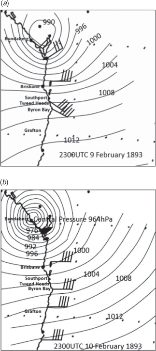
The largest recorded flood in Brisbane City was 8.35 m on 5 February 1893 (Brunt 1958; Newman 1958) and the unprecedented conditions resulted in at least 30 fatalities. Early on 3 February a 15.2-m high wall of water was observed to roar down a Brisbane River gorge. The water tumbled down the Stanley River to its junction with the Brisbane River. Nearby was Caboonbah, the residence of grazier Mr. H.P. Somerset. Caboonbah (Fig. 3a) is on high ground, with a view of the Brisbane River below its junction with the Stanley River. Crohamhurst (on the Stanley River) recorded 907 mm of rain in the 24 h to 9 am 2 February 1893 and this was an Australian record for 24-h rainfall up until 1979. The location of Crohamhurst and the 96-h rainfall is shown in Fig. 3b.

|
Somerset (1893) described in part the flood as follows: “It was raining, though not heavily when I heard a roaring sound, and looking west towards Mount Beppo (from which the sound seemed to come) I heard a louder noise quite different, so looking eastward I saw a wall of water fully 50 feet high coming around the bend. Astonished, I watched it pass the gum tree, and saw it submerge (i.e. exceed) the 1890 flood mark knob, and, while observing the tree, I felt the veranda floor lifting me, as the wall of water struck the cliff nearly two hundred yards away; the doors and windows rattled, the house shook as by an earthquake, and thinking my wife would be alarmed, I ran through a room, across the hall, and, on opening the door of her bedroom, she said ‘What has happened, I felt the bed shake under me’. I drew back the curtains and opened the window on the east veranda, so, from her bed, she saw the river nearing the top of the far bank, which the 1890 flood did not, and I, jumping through the window, on looking north, saw the flood not only covering the flat (nearly a mile wide) on the far side of the upper Brisbane River (whose channel it had overflowed) but also what looked like big logs racing along upstream in the distance away back from the river, so, getting my glasses, I saw clearly that they were saw-mill logs (as we found subsequently, when we saw them left high and dry near a drafting camp on a ridge in the top paddock) as being seven cedar logs bearing Mr. F. Bowman’s brand, which he got from a scrub near the head of Reedy Creek, which runs into the Stanley water on its far or eastern side, clearly showing that it was the Stanley water that had carried them to where it had left them.”
Somerset sent a horseman to Esk with a telegram addressed to the Postmaster-General in Brisbane: “Please warn inhabitants of Brisbane, Goodna, Ipswich, Lowood, other centres, of tremendous flood, 1890 level already exceeded several feet. Stanley River only, Brisbane to follow.” Somerset was correct as the flood peak when it reached Brisbane was devastating, with the Indooroopilly railway bridge swept away along with the Victoria Bridge in the Brisbane CBD. At least 150 houses were also swept down the Brisbane River with the flood peak.
During 31 January 1893, a severe TC approached land on a remote part of the Central Queensland Coast and was then steered southwards obviously under the influence of a middle to upper level trough. This deep layered trough influenced the development of an ECL southeast of the cyclone. The development and landfall of this ECL is shown in Fig. 4 and was associated with the extreme rainfall in SEQ which occurred over the four days, with the heaviest rainfall occurring as this ECL made landfall near the Sunshine Coast with 24-h totals to 907 mm and other 24-h registrations to 739 and 639 mm.

|
Confirmation of the wild coastal weather produced by this ECL were the exceptionally large seas reported off Cape Moreton, with vessels having departed the Port of Brisbane forced to turn back into Moreton Bay. There were extremely high tides at Sandgate on Moreton Bay near Brisbane with seawater flooding overland and large damaging waves on the beaches. This ECL on 5 February (not shown) began to merge with the remnant circulation of the cyclone and was also responsible for the large seas and winds, which drove the vessel Dickey ashore on the Sunshine Coast on 5 February.
3.4 Second 1893 flood
On 11 February1893, a short-lived TC crossed the coast near Bundaberg (see msl analysis in Fig. 5) adding to Brisbane floods where a peak of 2.15 m occurred on 12 February 1892. A schooner (150 tons) was wrecked at Inskip Point and a body of a man washed ashore. The barometer at Bundaberg fell 34 hPa in 24 h to noon 11 February, when it was 968.5 hPa (third lowest in Qld at the time). As 1100UTC 11 February, there was a 0.64-m storm surge in Moreton Bay (Gourlay 1981), and at Southport on 10 February the sea wall along the esplanade was destroyed and the baths irreparably damaged. Houses were flooded at Lismore and Grafton.
3.5 Third 1893 flood
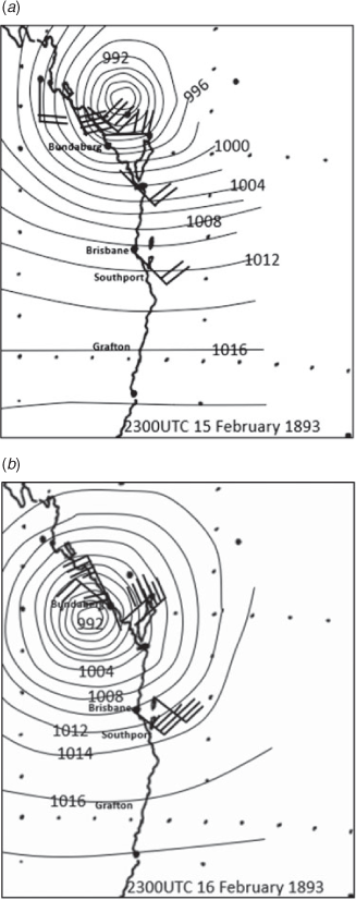
On 17 February 1893, another TC crossed the coast near Bundaberg (see msl analysis in Fig. 6) where a MSLP of 985.4 hPa was recorded. Floods in the Brisbane River rose again and at 0020UTC 19 February came within 25 cm of the peak reached a fortnight earlier and there were four drownings with floods from Rockhampton to Grafton. There were major floods at Murwillumbah, Lismore and Grafton. The 24-h rainfall was very heavy in SEQ with Crohamhurst recording 404.2 mm, Margate 440.7 mm and Sandgate 356.4 mm all on 17 February. At 0500UTC 17 February, a 0.61-m storm surge was recorded at Moreton Bay (Gourlay 1981) and at Sandgate there was severe wave damage.
3.6 Fourth 1893 flood
There was an ECL over 10–11 June 1893 causing three fatalities and severe sea damage at Sandgate and Cleveland with a 0.58-m storm surge on Moreton Bay (Gourlay 1981). Huge waves at Byron Bay destroyed a beached steamer. A low-pressure system crossed the coast near Rockhampton as it intensified (see msl analysis in Fig. 7). It then moved south just west of Brisbane and then turned towards the east passing just to the south of Tweed Heads on the afternoon of Saturday 10 June 1893. The Brisbane River peaked with a major flood in Brisbane City at 0000UTC 12 June 1893 of 3.63 m.
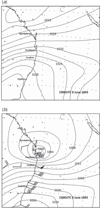
Major flooding occurred at Allora, Bundaberg, Maryborough and Gympie in Qld and at Lismore, Grafton, Kempsey, Bingara and Camden in NSW. Severe wave damage occurred at Forster, Ballina, Harrington, Wollongong and Sydney.
3.7 Fifth flood (1890)
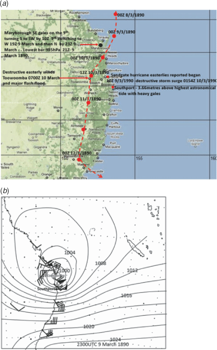
The Brisbane River peaked in Brisbane City at 5.33 m when a TC crossed the coast north of Noosa. The Superintendent of Telegraphs reported on a violent hurricane at Tewantin on the 9–10 March 1890, and at Cootharaba (25 km northwest of Noosa) houses were blown down and washed away by floods. This was the highest flood and strongest hurricane recorded in the district (see the msl analysis in Fig. 8 with the track also shown). There were 17 deaths from drowning: one at Tarampa, five in Brisbane and 11 in NSW. The vessel Agnes was lost north of Brunswick Heads with all hands; three bodies were washed ashore on 12 March and the other five bodies were never found.
|
At Southport there was a heavy gale and a heavier sea than had been observed for years. The swimming baths at the pier were completely swept away. An enormous sea broke right over the dressing boxes, a height of 3.66 m above high water mark where waves came over the swimming boxes. There were also severe storm surges at Sandgate and Redcliffe with waves breaking right over the jetties on 9 March. By 0600UTC 9 March, destructive winds struck Toowoomba. There were record floods in the Lockyer Valley, in Toowoomba and at Warwick, Moree, Coffs Harbour, Lismore, Grafton, Mclean, Taree, Port Macquarie, Camden, Mittagong, Wellington and in the Pine, Hawkesbury, Manning, Hastings and Hunter Rivers.
3.8 Sixth Flood (1887)
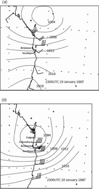
A TC crossed the coast north of Brisbane and there were at least 28 fatalities. There was a major flood in Brisbane City reaching 3.78 m on 23 January 1887. A ship, 43 km east-northeast of Noosa at 1000UTC 20 January 1887 reported hurricane force winds and the steamer Culgoa when 16 km south of Noosa encountered hurricane force winds around 1500UTC 20 January 1887 causing damage and injuring crew members (see msl analysis in Fig. 9). At Caboolture there were easterly gales from Thursday 20 January with a considerable number of trees blown down, telegraph lines smashed in all directions and the roads strewn with fallen timber.
|
Brisbane City recorded 465.1 mm in the 24 h ending 2300UTC 21 January 1887, which still stands as a 24-h rainfall record 132 years later. Easterly gales at Sandgate had seas breaking over the jetty, all the bathing houses were washed away and large trees were blown down in different directions. Many people were rescued from the South Pine River and 3.4 km of railway was washed away between Toombul and Bald Hills. Many people were drowned in the Logan River area. A boy was drowned near Greenmount on the Darling Downs on Saturday crossing a creek on horseback. The police at Harrisville reported a family of three were carried away by floods on Sunday night (23 January). The other members of the family were saved by trees. Two were drowned near Esk. Two people drowned in the Tenterfield area.
3.9 Seventh flood (1889)
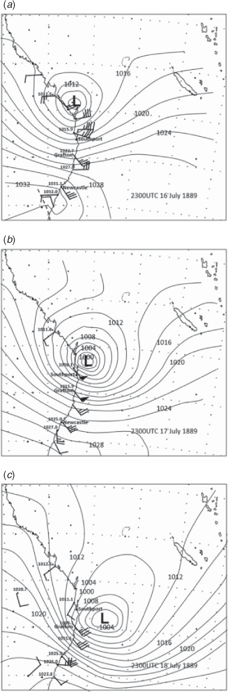
A major flood in Brisbane City reached 3.75 m at 0830UTC 20 July 1889. An intense low was near Rockhampton on 17 July 1889, near Brisbane on 18 July 1989 then moved southeast (see msl analysis in Fig. 10). There were gales and heavy seas on the north and central coasts of NSW. Many deaths resulted from 13 marine vessels lost or beached. There was a major flood at Grafton, a storm surge at Sandgate and a record storm surge at Southport.
|
3.10 Eighth flood (1898)
A tropical low moved southwest towards Fraser Island during 8–10 January 1898 then weakened and moved northeast of Bundaberg during 11–12 January 1898 (see msl analysis in Fig. 11). Three people drowned around Brisbane in floods with a major flood in Brisbane City at 0230UTC 13 January 1898 reaching 5.02 m.
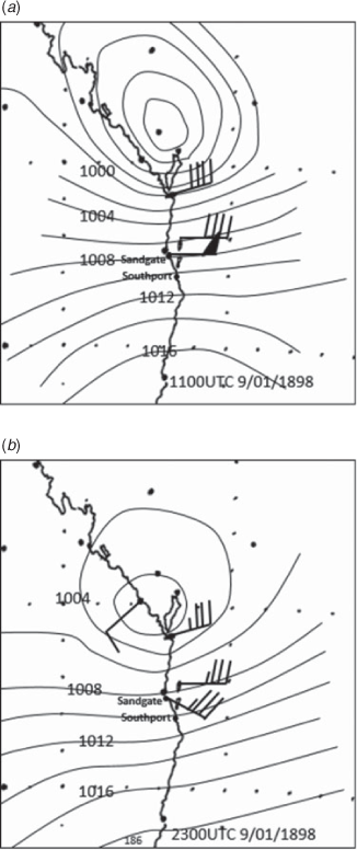
At Sandgate very strong east to southeast gales over 9–10 January reached hurricane force in the 3 h to 1700UTC 10 January and there was a large storm surge and waves at high tide that did much damage to seawalls, boats and roads etc.
There were also major floods in Breakfast Creek and Kedron Brook on Monday night 10 January 1898. Also, on 10 January, the steamer Ranelagh 836 tons was lost at Burnett Heads in a gale.
Very heavy daily rainfall totals occurred on the Sunshine Coast: Buderim 665.5 mm 10 January, 288.3 mm 11 January; Cooroy 275.6 mm 10 January, 342.9 mm 11 January; Landsborough 496.3 mm 10 January, 390.1 mm 11 January; Nambour 533.4 mm 10 January, 316.0 mm 11 January; Palmwoods 402.6 mm 11 January; and Yandina 489.0 mm 10 January, 291.3 11 January.
Heavy daily totals occurred around the Stanley River: 493.3 mm 10 January, 405.4 mm 11 January; and Woodford 190 mm 10 January, 290 mm 11 January.
3.11 Ninth flood (1898)
The TC Luita passed east of Brisbane and recurved towards the southeast over 6–7 March 1898 (see msl analysis in Fig. 12). There was 508 mm of rain recorded in 48 h at Crohamhurst. Gales and extremely high seas were observed along the south coast. A 3.27-m flood hit Brisbane City at 0700UTC 9 March 1898. On Monday 7 March, seas were breaking over private bathing houses at Shorncliffe. There were major floods at Lismore and Murwillumbah.

4 Weather systems and their effect on Jumpinpin
Above it was shown that the flood events also caused coastal wave and storm surge damage in SEQ. In this section are further events which impacted on this area. This coastal ocean damage focuses on the Jumpinpin (Fig. 1) region of Stradbroke Island from the observations at Southport, Sandgate and other Moreton Bay locations. The full ocean impacts of all the storms which impacted SEQ and NSW over the study period are described in Appendix 1.
Around 1883–1885 the inner shore of Jumpinpin (sheltered waters south of Moreton Bay) was lightly fringed with mangroves with only one sandy spot to land and after this one had to pass over two sand ridges grassed with Pandanus trees to reach the ocean beach (Brisbane Courier Report 17 April 1895). Over the period to April 1895, around 400 m of the mangroves had been replaced by a clean sandy beach. Then there was only one ridge (much lower) between the bay and the ocean. Evidence that the sea has been eating into the land was that, in 1895, Pandanus trees for miles along the ocean beach were strewn with some still green, indicating recent erosion. Evidence of black mud and mangrove roots along the ocean beach indicated this was formerly the shore of the inner bay.
There was a severe weather event affecting this area during February 1883 (see below) and this may have been the first erosion episode leading into the 1883–1898 sequence of erosion. A report from the Boatman Pilot of Southport on 5 March 1895 (Brisbane Courier) stated that after the disturbance of TC Mu (see report below) he visited the scene of the Cambus Wallace wreck. After destroying one case of dynamite he went north along the beach and found, at a point 5.6 km from Jumpinpin, a break in the sand had been made by the wave action right through to Swan Bay (southern of Moreton Bay) and that ordinary spring tides washed over into the bay, the opening being about 400 m wide. The conclusion the pilot made was that there was an entrance at this spot from the ocean to the bay. He found no outflow from the bay but if the opening increased in depth and such an outflow became established the water would soon make a large channel for itself. To him it seemed likely then that the low southern part of Stradbroke would be cut off from the hilly northern part.
After three 1898 storms (see below), the Inspector of Shipping and Fisheries inspected the breakthrough which had then formed at Jumpinpin (Brisbane Courier report). The Cambus Wallace was then standing on a precipitous face 15.2–18.3 m high on the southern side of the channel through to the ocean. On the north side of the break, which was 800-m wide, cows and horses belonging to the oysterman at Curragee (9.7 miles from Southport) were grazing and he was happy for the time being as they had plenty of water and food. This was evidence that the large breakthrough was a recent event, while the owner considered ways to recover his cattle. All this is evidence that after the 1895 event (TC Mu) the whole area of Jumpinpin was weakened, leaving it susceptible to a breakthrough and the three 1898 storms were the culminating events which forced the channel through at Jumpinpin rather than the location 5.6 km further north.
5 Other severe coastal damage events
Below are the additional events that caused erosion around Jumpinpin.
5.1 1883 event
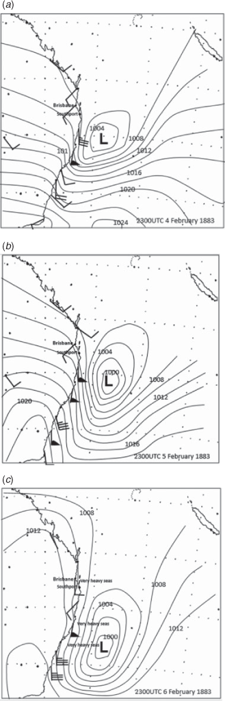
An intense low developed east of Coffs Harbour on 5 February 1883 and then moved south to the east of Newcastle 7 February 1883 (see msl analysis in Fig. 13). Storm-force southerly winds along the NSW coast with a huge southerly swell extended up to waters near Brisbane. There was an exceptionally large high tide at Moreton Bay on 7 February 1883 and a considerable amount of low-lying land was flooded. At Southport, the tide was the highest ever known with the sea inflicting damage to the road between Labrador and Southport and washing away the boat houses on the Southport Beach. The southerly gales suggest a Kelvin wave type surge (Fandry et al. 1984). The ocean liner Sorato was irreparably damaged by tremendous seas on Friday 3 February 1883 as it left Sydney for Melbourne.
|
5.2 1887 event
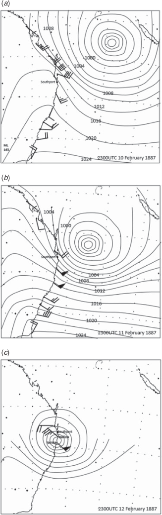
A TC over 8–13 February 1887 passed east of Brisbane at 1830UTC 13 February 1887, where the barometer dropped to 992.9 hPa (see msl analysis in Fig. 14). Four known fatalities occurred from six foundered vessels.
|
Southport had an enormous tide on Saturday night (12 February), the highest for many years. The sea wall and the seaside baths were severely damaged and a dozen boats damaged. The sea washed right over the spit. Destructive winds hit Yamba and Grafton and an all-time record 24-h rainfall occurred at Warwick of 195.3 mm.
5.3 1891 event
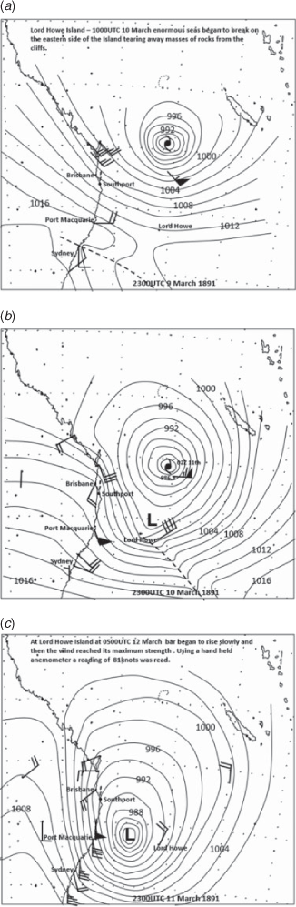
A TC from the northern Coral Sea on 9 March 1991 moved down to the east of Fraser Island by 11 March and then moved south to the east of Southport by 11 March before turning southeast (see msl analysis in Fig. 15).
|
On Thursday morning 12 March, Southport reported a terrific sea on the bar, with the tide being the highest ever known. Immense damage was done to the esplanade. The sea walls and the jetty were severely damaged, and the jetty house was carried away. The barque Don Nicolas foundered at 0000UTC 13 March and the crew took to boats. After a long voyage, the two lifeboats made Sydney Heads on Saturday night 21 March. The Rose M barque 366 tons foundered on a voyage from New Zealand to Melbourne and wreckage was washed ashore on 16 March at Crowdy Head. On Lord Howe Island, on Thursday morning 12 March, the reef on the west side had enormous seas with spray whipped up by the wind. The tide was abnormally high and there was widespread wind damage, with huge trees uprooted or broken down and buildings unroofed. The violence of the gales on the coast near Forster was unprecedented. The heavy sea broke clean into the harbour and did much damage.
5.4 1892 event
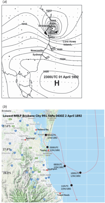
A TC came close to the coast near South Stradbroke Island on 2 April 1892 (see msl analysis in Fig. 16a and its track in Fig. 16b) then turned back out to sea, causing five deaths. Wind raged from 8 am to 4 pm Saturday 2 April and the lowest bar at Brisbane (corrected to sea level) was 991.5 hPa at 2.30 pm, when Clement Wragge quoted the wind strength in Brisbane as 60–70 knots from the southwest.
|
There was widespread severe structural damage in the inner suburbs of Brisbane, mainly in the lee of the Taylor Range. There was also severe wind damage at Beenleigh, Redland Bay, Tweed Heads and Southport, where the sea came up over the esplanade in places and around 140 m of the seawall was washed away. The schooner Bellringer with cargo of cedar was driven ashore at Stradbroke Island. There was a 0.61-m surge in Moreton Bay (Gourlay 1981). There were major floods at Grafton, Lismore Armidale, Taree and Kempsey, and at Ballina the south spit was washed away, leaving an opening of nearly 3.5 km.
5.5 1894 event
Over 18–19 February 1894, a TC passed east of Brisbane, and then moved to the Lord Howe Island area (see msl analysis in Fig. 17). A storm surge of 0.58 m was measured on the tide gauge at Moreton Bay (Gourlay 1981).
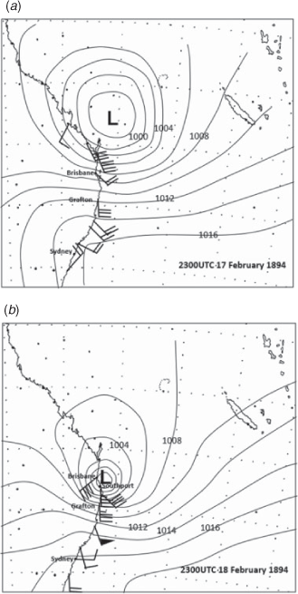
The tide in the Brisbane River Monday (19 February) rose to an abnormal height, with many of the low-lying wharves under a metre of water, and several ferry landings were unapproachable. The highest tide ever known occurred at Cleveland. At Southport, the low-lying lands along the esplanade were inundated, several bathing houses were destroyed, while others were left in a tottering condition. At Ballina, a very heavy tide covered all the lower parts of town.
5.6 Second 1894 event
On 13 March 1894, a TC passed east of Cape Moreton with severe gales (see msl analysis in Fig. 18).

The Cape Moreton lighthouse experienced severe wind damage at 1300UTC 13 March. A major flood in the Tweed River reached 5.04 m at Murwillumbah. Gales damaged crops at Wynnum/Cleveland and in the Redlands areas, and floods damaged crops in the North and South Pine Rivers. The schooner Grace Darling was wrecked at Comboyora Point, Moreton Island, at 5.10 pm 13 March. The crew were saved.
5.7 Cambus Wallace
On 3 September 1894, a severe low-pressure system was well out to sea passing east of Southport. The next day, on 4 September 1894, there was severe damage from the low at Lord Howe Island with winds wrecking the school, causing severe damage to several homesteads and many forest trees were blown down. Conditions on the Gold Coast were such that Southport on 3 September 1894 had strong southeast winds with misty or foggy conditions and a heavy swell. At Tweed Heads, the observation at 1000UTC 3 September 1894 was light southerly winds and heavy seas. On 3 September 1894, the barque Cambus Wallace (1651 tons) thought they were 57 km off the land in misty or foggy conditions and struck the breakers 180 m off Stradbroke Island, with five seamen drowned and one dead of exposure. Residents at the Moreton Bay suburbs of Lytton and Wynnum heard the noise of the swell from the east coast of Stradbroke Island giving some idea of the size of the waves. The ship was on its maiden voyage from Glasgow to Brisbane. The low was too far out to sea to obtain observations useful for a msl analysis.
5.8 TC Mu January 1895 (named by legendary meteorologist Clemente Wragge)
At 2300UTC 28 January, a TC was northeast of Brisbane and at 2300UTC 29 January it was 240 km east of Wide Bay, at 2300UTC 30 January the low was east of Point Danger, at 2300UTC 31 January it was moving towards Lord Howe and at 2300UTC February it was near Lord Howe Island (see msl analysis in Fig. 19).

|
There was much damage at Southport from the sea to jetties roads etc., with the main pier caved in. Along 5 km of the esplanade, the sea eroded the road with breaks every hundred metres or so. The toilets facing the south disappeared. About 120 m of the south spit, at the entrance to Nerang Creek on the ocean side, was eroded away (making a total of 576 m in rather less than eight years), and that point presented a steep wall of sand to the surf beating at the foot thereof. On the other side of the entrance, on Stradbroke Island, the waves were running inland among the sand hills for over several hundreds of metres. The coach with the Sydney mails was blocked by the storm surge in Currumbin Creek on Wednesday.
Double Island Point felt the full force of the hurricane on Wednesday night (30 January). The Chief Keeper’s house was unroofed, and seas were mountainously high. There was severe damage to the western pier at Kiama. Immense waves were breaking right across the bay. Extremely high seas washed away a wharf at Harrington. The largest seas in memory were breaking two miles seaward. The heaviest and most dangerous sea for years hit Sydney on Saturday afternoon 2 February. Crowds of people visited The Gap to view the spectacle. There were major floods at Murwillumbah, Casino and Grafton.
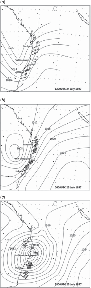
5.9 ECL July 1897
During 24–26 July 1897, a low from Qld moved southeast into the Tasman Sea on Monday 26 July 1897 (see msl analysis in Fig. 20). The schooner Heroine was driven ashore at North Kirra near the mouth of Coolangatta Creek (30 km south of Southport) on Sunday 25th. On 26 July 1897, the breakwater was damaged at Macleay River Heads.
|
6 Climatology of severe ocean events
6.1 No Jumpinpin in 1846
The vessel Coolangatta was beached at the town which would bear its name during an ECL on 19 August 1846. It was repaired and then wrecked by another gale on 4 December 1846. The crew were then able to walk to Amity Point on the northwest tip of Stradbroke Island (Fig. 1), which was evidence that at the time Stradbroke Island was attached to the mainland with no break at Jumpinpin. There was an extensive negative Southern Oscillation Index (SOI) period from 1820 to around 1850 (Braganza et al. 2009), consistent with little barrier island erosion enabling the crew to walk to Amity Point.
Power and Callaghan (2016b) found a strong relationship from weather systems producing severe coastal flooding and positive phases of SOI; Callaghan and Power (2011) found the same for severe TCs affecting eastern Australia. Fig. 21 displays a time series of the cumulative SOI from 1876 to 2019. To generate this curve, the monthly values of the SOI are simply continually added. A succession of positive values causes the curve to rise and the opposite occurs for sustained negative values. Events shown in Appendix 1 are analysed using this cumulative SOI curve. Below rising (positive) SOIs are highlighted (+) with negative values (−).

|
Lists of event sequences during different phase of the SOI – positive (+) and negative (−)
(+) January 1876 to September 1876, two events
(−) October 1876 to June 1878, one event
(+) June 1878 to April 1881, five events
(−) April 1881 to November 1885, four events
(+) November 1885 to December 1887, three events
(−) December 1887 to May 1890, five events
(+) May 1890 to February 1895, 15 events in 4 years and 9 months
(−) February 1895 to July 1897, two events
(+) August 1897 to May 1904, seven events
(−) June 1904 to June 1906, one event
(+) Jul 1906 to April 1911, six events
(−) May 1911 to May 1915, six events
(+) June 1915 to May 1918, two events
(−) June 1918 to April 1920, one event
(+) May 1920 to April 1925, five events
(−) April 1925 to August 1926, one event
(+) September 1926 to Jul 1939, 20 events
(−) July 1939 to April 1942, one event
(+) May 1942 to February 1946, three events
(−) March 1946 to July 1949, six events
(+) Jul 1949 to February 1951, five events
(−) March 1951 to December 1953, four events
(+) December 1953 to January 1957, nine events
(−) February 1957 to August 1959, seven events
(+) September 1959 to November 1964, 10 events in 6 years 2 months
(−) December 1964 to November 1966, four events
(+) December 1966 to August 1968, seven events in 1 year 8 months
(−) September 1968 to March 1970, one event
(+) April 1970 to February 1972, three events
(−) March 1972 to April 1973, nil events
(+) April 1973 to June 1976, 11 events in 3 years 2 months
(−) July 1976 to January 1988 13 events
(+) February 1988 to October 1989, six events in 1 year 8 months
(−) November 1989 to June 1995, seven events
(+) June 1995 to February 1997, three events
(−) March 1997 to April 1998, one event
(+) May 1998 to April 2001, six events
(−) May 2001 to May 2007, 13 events
(+) May 2007 to September 2013, 20 events in 6 years 4 months
(−) January 2014 to April 2016, four events
(+) May 2016 to May 2018, six events
(−) June 2018 to February 2020, four events
In total during 1876–2020 there were 153 events with a positive SOI trend and 86 events with a negative trend. This follows other studies above where stronger impacts occur during the positive phases of the SOI. The strongest sequences above have added to them the years and months over which the events occurred and the top three follow:
May 1890 to February 1895, 15 events in 5 years and 3 months – six of these were during 1893
December 1966 to August 1968, 7 events in 1 year 8 months – six of these were during 1967
April 1973 to June 1976, 11 events in 4 years 2 months.
Not surprisingly the most active periods were in 1893 and 1967, which led to the breakthrough at Jumpinpin and the AU$9 billion erosion on the Gold Coast during 1967 respectively.
Before the 1976 climate shift, from May 1920 to June 1976 there were 72 positive and 24 negative SOI events. This comprised 14 TI1 events, one TI2 event, 28 TI3 events, 42 ECLs and 11 Tasman Sea lows.
Following the 1976 climate shift, from July 1976 to April 1998 there were nine positive and 21 negative SOI events. This comprised 10 TI3 events, 13 ECLs and seven Tasman Sea lows.
Following resumption of sustained positive SOIs from May 2007 to January 2014 there were 20 positive events comprising three TI3s, 14 ECLs and three Tasman Sea lows.
This shows how direct TC impacts TI 1 on the study area decreased markedly following the June 1976 climate shift.
7 Extra severe events during the 1883–1898 period without evidence of extreme wave damage at Southport
These events probably added to the seas around Stradbroke Island but more importantly they added to the enormous sequence of extreme events during 1883–1898. The TC Eline/Monsoon low Ramagh event is probably one of the worst events to hit the general Sydney area.
7.1 13–15 July 1887
Small low developed east of Brisbane. Parts of Brisbane flooded. Nerang recorded an all-time daily rainfall record for July and second highest of all time (station still open) 349.5 mm in 24 h to 2300UTC 13 July 1887, 106.2 mm next day.
7.2 26 May 1889
Tropical low crossed the coast at Fraser Island on Sunday 26 May 1889 and passed inland to Miles before recurving and passing out to sea again near Yamba on Monday 27 May. Huge seas in Sydney; some buildings were washed away by floods, houses unroofed and fences blown down. Flooding at Newcastle, Lithgow and a major flood in the Georges River of 9.7 m at Liverpool Weir, the second highest of all time. Severe wave damage at Port Stephens, Kiama and Port Kembla. There were four fatalities.
7.3 17–18 February 1888
A TC recurved just east of Mackay on 17–18 February 1888. Six fatalities. Main damage Mackay to Hervey Bay with strong gales in SEQ.
7.4 24–28 March 1890, 18 fatalities
A TC crossed the North Queensland coast near Cardwell on 24 March 1990 and recurved over Fraser Island on 28 March, bringing disastrous floods over much of Qld and northern NSW. On the Darling Downs, two policemen missing in floods near Dalby and at Roma, and 100 people were evacuated from the floods. At Beaudesert, a man drowned on 28 March and in Texas numerous buildings were washed away, a man drowned and many livestock were lost. In NSW, the Nepean River flooded with one drowning. There were major floods at Grafton, Maclean, Bingara and Moree.
7.5 12-14 February 1898 monsoon low Ramagh, 31 fatalities
On 12–14 February 1898, intense monsoon low Ramagh tracked from the continent to intensify over northeast NSW; it was probably a continuation of severe TC Eline that struck Mackay (Callaghan and Power 2011).
The brig Amy (220 tons) after leaving Wollongong at 9 am 14 February was driven ashore near Bulli and the eight crew all drowned. Another man died on the beach from shock. The brigantine Malcolm foundered at Bulli and the six crew were lost, and 500 feet of the Bellambi jetty was washed away. The ship Atacama was abandoned well off the NSW coast on 9 February 1898 after it began leaking. As they sailed back towards the New South Wales coast in lifeboats they encountered the intense low pressure system and 13 of the crew were drowned.
Three men drowned at Bungendore and Tumut (near Canberra) in floods on 15 February. In Sydney, trees were uprooted, verandas were carried away and the ferries were suspended. The yacht Greyland capsized (crew saved) in the harbour. There were 31 known deaths associated with this event.
The Georges River on Monday 14 February reached 9.0 m at Liverpool Weir (ranked third) and 5.5 m at Lansdowne Bridge. Severe flood damage at Liverpool and Bankstown.
The Bega River recorded one of its highest floods with much damage. The flood attained its highest at 2 am Tuesday 15 February.
Hunter River at Maitland on Tuesday night (15 February) reached 9.14 m, with farms badly flooded in the district.
Nepean/Hawkesbury Rivers: the height at Windsor Bridge reached 9.61 m on 15 February and caused serious crop damage. The Nepean River at Campbelltown caused severe flooding in homesteads and on 15 February reached a height 0.91 m below the record 1843 flood. At Douglas Park (near and east of Picton) the Nepean River rose with a great rush Monday night, submerging the bridge and all the low-lying flats. It was the largest flood experienced for 25 years. At Moss Vale, at about 10.30 am Monday morning, very heavy rain fell and lasted for several hours, causing a great flood in the town, in which numerous shops and dwellings and other places of business were completely flooded, as well as a great number of fences broken down and washed away by the force of the water.
Major flood Nowra 5.0 m; major flood Moruya.
Unprecedented 24-h rainfall totals:
West Sydney/Blue Mountains – Glenfield 31 km WSW of Sydney 186.7 mm, 14 February; Penrith 158.8 mm, 14 February; Blackheath 11 km N of Katoomba 61.7 mm, 13 February, and 170.2 mm, 14 February; Lawson 11 km E of Katoomba 132.1 mm, 13 February, and 219.7 mm, 14 February; and Springwood 23 km E of Katoomba 86.6 mm, 13 February and 220.7 mm, 14 February.
Illawarra – Brogers Creek 22 km NNE of Nowra 57.2 mm, 13 February, and 509.3 mm, 14 February, a February record for 1890–1930; Cordeaux River 573 mm, 14 February, and 102.6 mm, 15 February, an all-time daily record on 14 February for 1871–1924; Sherbrooke 14 km N of Wollongong 63.8 mm on 12 February, 435.4 mm on 13 February, and 41.9 mm on 14 February, an all-time daily record on 13 February for 1892–1970.
South Coast – Araluen 83.8 mm on 13 February, 267.0 mm on 14 February, and 339.3 mm on 15 February; an all-time February daily record rainfall for 1891–1970.
8 Conclusion
Twenty-five severe weather events (including the Cambus Wallace storm) have been described. These storms caused disastrous flooding over SEQ and large areas of NSW. Brisbane City over this period experienced six major floods, including the two highest floods on record within a fortnight. The first of these two brought a huge wall of water from the Stanley River down the Brisbane River Valley which ultimately swept away two city bridges and 150 houses. Such an occurrence today would surely test the management of Somerset Dam and Wivenhoe Dam inflows, given the problems that occurred with managing the much weaker inflows into Wivenhoe Dam following an intense burst of rainfall during the Brisbane 2011 floods (van den Honert and McAneney 2011). Eighteen of these storms appeared to have generated ocean conditions conducive to severe beach erosion to the east coast of Stradbroke Island. Reports by experienced observers indicated the breakthrough at Jumpinpin on Stradbroke Island was a gradual process following an unusually large number of storms over a relatively short period. Popular mythology had the breakthrough created by many visitors travelling to the Cambus Wallace wreck to sample the Scotch whisky contained in the cargo of the Scottish wreck, thereby contributing to the erosion there. Given that the 1967 storms generated normalised insurance losses of around AU$9 billion, it is sobering to surmise the huge losses this sequence of late-nineteenth century storms could incur today from wave erosion, storm surge flooding, fresh water flooding and severe wind gusts in the fastest growing area in Australia. Of the 24 storms that directly impacted the Australian east coast, 19 occurred during a positive phase of the SOI and five during a negative phase. A climatology study of 239 Australian east coast storms that caused severe ocean damage between Brisbane and the Victorian border over the period between 1876 and February 2020 showed that 153 events occurred with a positive SOI trend and 86 events with a negative trend. The most active years were 1893 and 1967, both during a positive SOI period and both dominated by TC activity. The 1893 events strongly contributed to the Jumpinpin breakthrough and 1967 was associated with historical Gold Coast beach erosion, which contributed to AU$9 billion insurance losses. The study also showed how direct TC impacts in the study area decreased markedly following the June 1976 climate shift.
Conflicts of interest
The author has no conflict of interest in publishing this paper.
Acknowledgements
The author acknowledges the effort by the two anonymous reviewers whose suggestions expanded the paper into a more worthwhile description. This research did not receive any specific funding.
References
Browning, S. A., and Goodwin, I. D. (2016). Large scale drivers of Australian East Coast Cyclones since 1851. J. South. Hemisph. Earth Syst. Sci. 66, 146–171.Brunt, A. T. (1958). Analysis of two Queensland Storms. Conference on the Estimation of Extreme Precipitation, Bureau of Meteorology, Melbourne, 22–24 April 1958, pp. 191–228.
Blain, Bremner and Williams Pty Ltd. (1985). Elevated Ocean Levels Storms affecting NSW Coast 1880-1980. Report number 85041 Public Works Department (NSW) Coastal Branch. 286 pp.
Braganza, K., Girgis, J. L., Power, S. B., Risbey, J. S., and Fowler, A. M. (2009). A multiproxy index of the El Nino Southern Oscillation, A.D. 1525-1982. J. Geophys. Res. 114, .
| A multiproxy index of the El Nino Southern Oscillation, A.D. 1525-1982.Crossref | GoogleScholarGoogle Scholar |
Callaghan, J., and Helman, P. (2008): Severe Storms on the East Coast of Australia 1770–2008 Griffith Centre for Coastal Management, Griffith University, and Gold Coast Queensland.
Callaghan, J., and Power, S. B. (2011). Variability and decline in the number of severe tropical cyclones making landfall over eastern Australia since the late nineteenth century. Clim. Dyn. 37, 647–662.
| Variability and decline in the number of severe tropical cyclones making landfall over eastern Australia since the late nineteenth century.Crossref | GoogleScholarGoogle Scholar |
Callaghan, J., and Power, S. B. (2014). Major coastal flooding in south-eastern Australia 1860–2012, associated deaths, and weather systems. Aust. Meteorol. Oceanogr. J. 64, 183–213.
| Major coastal flooding in south-eastern Australia 1860–2012, associated deaths, and weather systems.Crossref | GoogleScholarGoogle Scholar |
Delft Hydraulics (1970). Gold Coast Queensland Australia Coastal Erosion and Related Problems Volumes I and II, Delft Hydraulics Laboratory The Netherlands.
Fandry, C. B., Leslie, L. M., and Steedman, R. K. (1984). Kelvin-Type Coastal Surges Generated by Tropical Cyclones. J. Phys. Oceanogr. 14, 582–593.
| Kelvin-Type Coastal Surges Generated by Tropical Cyclones.Crossref | GoogleScholarGoogle Scholar |
Gourlay, R. J. (1981). Storm surges in the Brisbane Roads. Technical Report. Bureau of Meteorology , 20.
Hopkins, L. C., and Holland, G. J. (1997). Australian Heavy-Rain Days and Associated East Coast Cyclones: 1958–92. J. Climate 10, 621–35.
| Australian Heavy-Rain Days and Associated East Coast Cyclones: 1958–92.Crossref | GoogleScholarGoogle Scholar |
Hunt, H. A., 1914. Commonwealth Meteorologist. Results of Rainfall Observations in Queensland to 1913, 283 pp.
McAneney, J., Sandercock, B., Crompton, R., Mortlock, T., Musulin, R., Pielke, R., and Gissing, A. (2019). Normalised insurance losses from Australian natural disasters: 1966–2017. Environ. Hazards 18, 414–433.
| Normalised insurance losses from Australian natural disasters: 1966–2017.Crossref | GoogleScholarGoogle Scholar |
McCauley, E., and Tomlinson R. (2006). The evolution of Jumpinpin Inlet Technical Report 62 Cooperative Research Centre for Coastal Zone, Estuary and Waterway Management Griffith University Gold Coast Queensland 88 pages.
Newman, B. W. (1958). Australia’s highest daily rainfall. Australian Met. Mag. 20, 61–65.
Ji, F., Pepler, A. S., Browning, S., Evans, J. P., and Di Luca, A. (2018). Trends and low frequency variability of East Coast Lows in the twentieth century. J. South. Hemisph. Earth Syst. Sci. 68, 1–26.
| Trends and low frequency variability of East Coast Lows in the twentieth century.Crossref | GoogleScholarGoogle Scholar |
Pepler, A. S., and Rakich, C. S. (2010). Extreme inflow events and synoptic forcing in Sydney catchments. IOP Conf. Ser.: Earth Environ. Sci. 11, 012010.
| Extreme inflow events and synoptic forcing in Sydney catchments.Crossref | GoogleScholarGoogle Scholar |
Pepler, A., Coutts-Smith, A., and Timbal, B. (2014). The role of East Coast Lows on rainfall patterns and inter-annual variability across the East Coast of Australia. Int. J. Climatol. 34, 1011–1021.
| The role of East Coast Lows on rainfall patterns and inter-annual variability across the East Coast of Australia.Crossref | GoogleScholarGoogle Scholar |
Pepler, A. S., Fong, J., and Alexander, L. V. (2017). Australian east coast mid‐latitude cyclones in the 20th Century Reanalysis ensemble. Int. J. Climatol. 37, 2187–2192.
| Australian east coast mid‐latitude cyclones in the 20th Century Reanalysis ensemble.Crossref | GoogleScholarGoogle Scholar |
Power, S. B., and Callaghan, J. (2016a). The frequency of major flooding in coastal southeast Australia has significantly increased since the late 19th century. J. South. Hems. Earth Sys. Sci. 66, 2–11.
Power, S. B., and Callaghan, J. (2016b). Variability in Severe Coastal Flooding, Associated Storms, and Death Tolls in southeastern Australia since the Mid-Nineteenth Century. J. Appl. Meteorol. Climatol. 55, 1139–1149.
| Variability in Severe Coastal Flooding, Associated Storms, and Death Tolls in southeastern Australia since the Mid-Nineteenth Century.Crossref | GoogleScholarGoogle Scholar |
Somerset, H. P. (1893). Recollections of the 1893 Flood. MS. Fryer Library, University of Queensland.
Speer, M. S., Wiles, P., and Pepler, A. (2009). A. Low pressure systems off the New South Wales coast and associated hazardous weather: establishment of a database. Aust. Met. Mag. 58, 29–39.
| A. Low pressure systems off the New South Wales coast and associated hazardous weather: establishment of a database.Crossref | GoogleScholarGoogle Scholar |
van den Honert, R. C., and McAneney, J. (2011). The 2011 Brisbane Floods: Causes, Impacts and Implications. Water 3, 1149–1173.
| The 2011 Brisbane Floods: Causes, Impacts and Implications.Crossref | GoogleScholarGoogle Scholar |
Visher, S. S., and Hodge, D. (1925). Australian Hurricanes and Related Storms with an Appendix on Hurricanes in The South Pacific, Published by the Bureau of Meteorology, 54 pp.
Watt, W. S. (1940). Results of Rainfall Observations in Queensland, 79 pp.
Appendix 1. List of severe weather events, meteorological system responsible and associated death toll
Weather types: TI1, Tropical Cyclone (TC); TI 2, Trough extending south from a TC; TI3, Extratropical transformation of TC or low; ECL, East Coast low; TAS, Tasman Sea Low. Fatalities in last four columns: I, freshwater floods; II, over land; III, surf zone and storm surge; and IV, at sea

|