

Fuel and topographic influences on wildland firefighter burnover fatalities in Southern California
Wesley G. Page A B and Bret W. Butler A BA USDA Forest Service, Rocky Mountain Research Station, Fire, Fuels, and Smoke Program, 5775 Highway 10 W, Missoula, MT 59808, USA.
B Corresponding authors. Email: wesleygpage@fs.fed.us; bwbutler@fs.fed.us
International Journal of Wildland Fire 27(3) 141-154 https://doi.org/10.1071/WF17147
Submitted: 30 September 2017 Accepted: 20 January 2018 Published: 28 March 2018
Journal Compilation © IAWF 2018 Open Access CC BY-NC-ND
Abstract
Previous reviews of wildfires where a fatal firefighter burnover occurred have found that the incidents usually share similar characteristics in terms of the fire environment, such as steep slopes and complex topography (e.g. box canyons). Despite these similarities, systematic identification and communication of the locations where these conditions prevail are rare. In this study we used a presence-only machine-learning algorithm (Maximum Entropy, MaxEnt) coupled with spatial location information from past fatal firefighter burnovers to identify and characterise the environmental variables that are likely to produce conditions suitable for a fatal burnover. Southern California was chosen to conduct the analysis as it has a well-documented history of past fatal firefighter burnovers and a complex fire environment. Steep, south-west-oriented slopes located in canyons with a shrub fuel type were found to be the most dangerous locations for firefighters. The relative danger to firefighters from a fatal burnover is described and summarised at both the 30-m pixel and local watershed scale.
Additional keywords: fire behaviour, entrapment, firefighter safety, fire environment.
Introduction
The physical characteristics of the terrain where wildland fires occur, including slope steepness and shape, have long been known to be important factors affecting fire behaviour and firefighter safety (Barrows 1951). Although the exact mechanisms by which slope enhances fire behaviour are not entirely clear, it is thought that increased convective and radiant heating towards unburned fuels due to a change in flame angle rapidly increases spread rate, especially when flames become ‘attached’ to the slope (Rothermel 1985; Weise and Biging 1996; Butler et al. 2007). Flame attachment and the resulting dramatic increase in rate of spread generally occurs because of a combination of the increased velocity of hot gases in physically constricted areas, i.e. the Venturi or chimney effect, and the Coandă effect, which causes the buoyant plume to attach to surfaces due to the inability to entrain air from the side adjacent to the surface (Simcox et al. 1992; Gallacher et al. 2018). Slopes steeper than ~45% (~24°) appear to be most prone to flame attachment and have been implicated as a contributing factor in case studies of firefighter burnover incidents (Sharples et al. 2010) and civilian deaths in a confined escalator (Edgar et al. 2016).
In combination with slope steepness, terrain shape and configuration, particularly in relation to canyons, have also been shown to be important considerations for fire behaviour and firefighter safety (Viegas and Pita 2004; Viegas and Simeoni 2011). For example, local and broad-scale terrain features have been noted to enhance the potential for dynamic and thermally driven winds, including foehn and gap winds, valley winds, and winds due to chimney effects, which raises the potential for extreme fire behaviour and potentially threatens firefighter safety (Schroeder and Buck 1970; Clements 2011). Viegas and Simeoni (2011) described the rapid acceleration of fire spread that is common where wind and slope align as ‘eruptive’ fire behaviour and highlighted the potential contribution of these conditions to wildland firefighter fatalities through mechanisms including positive feedbacks, gas accumulation, flow attachment, change in wind direction or velocity, thermal belts, atmospheric instability and spot fires. The rapid increase in fire behaviour associated with eruptive conditions often surprises firefighters, making previously identified escape routes, escape times and safety zones inadequate, which can sometimes result in death or serious injury (Rothermel 1993; Butler et al. 1998; Cheney et al. 2001; Viegas and Simeoni 2011). Recent research has also shown that firefighters who are entrapped by a fire on steep slopes have a significantly lower likelihood of survival than firefighters entrapped on flatter terrain (Page and Butler 2017).
Owing to the potential for extreme fire behaviour in areas with complex topography, wildland firefighters are often trained to recognise and avoid specific topographic features including; steep slopes, chutes or chimneys, box canyons, saddles and narrow canyons (National Wildfire Coordinating Group 2014). The importance of these specific terrain features in terms of wildland firefighter safety is based in large part upon previous analyses of firefighter fatalities, such as by Wilson (1977), who found that an increase in fire behaviour due to fires moving rapidly uphill in chimneys, gullies or on steep slopes was a common element in firefighter fatalities in the USA. Other work has also argued that the effects of solar radiation on fuel flammability, especially when coupled with topography, is key to accurately predicting fire spread and determining firefighter suppression success (Countryman 1966; Campbell 2005). Recognising these elements within the fire environment is often described as gaining situational awareness or using your senses to gather information about your surroundings (National Wildfire Coordinating Group 2007). Improved situational awareness and a willingness to learn from previous experiences enhances firefighter safety, which is often a focus of firefighter training (Fig. 1).

|
Southern California represents a unique combination of flammable vegetation, complex topography and critical fire weather (Countryman 1974; Sugihara et al. 2006). The region encompassing the 10 southernmost countiesA in California is dissected by two distinct mountain ranges; the Transverse Range that runs west to east across Santa Barbara and San Bernardino Counties and the Peninsular Range that runs south to north, approximately parallel to the coastline (Jahns 1954). The groups of mountains that encompass these two ranges cover large environmental gradients in terms of elevation, climate and vegetation composition. Individual mountain ranges can have elevations that go from near sea level to more than 3500 m with strong rain-shadow effects producing large variations in precipitation from the Pacific Coast in the west to the Mojave Desert in the east (Schoenherr 1995). The complex topography also produces varied landforms including steep canyons and desert plains that sometimes meet in mountain gaps that are known to amplify the effects of local katabatic winds, also known as Santa Ana winds, that help produce large fire events in the fall and early winter (Hughes and Hall 2010; Moritz et al. 2010).
Coincident with the complex topographic features of Southern California is the presence of a plant association referred to as Chaparral. Chaparral is typically located on steep slopes between 300 and 3000 m in elevation with nutrient poor soils where average annual precipitation is between 300 and 600 mm (Tyrrel 1982). This plant community is widely considered to be one of the most flammable in North America and as such is recognised by firefighters to produce extreme fire behaviour, especially during high winds (Rothermel and Philpot 1973; Paysen and Cohen 1990). Several high-profile firefighter burnover incidents have occurred in Chaparral located within Southern California including the Esperanza (Maclean 2013), Canyon (Countryman et al. 1969), Loop (Countryman et al. 1968) and Inaja (USDA Forest Service 1957) fires.
Although there is adequate evidence available to characterise the environmental conditions that can lead to the potential for eruptive fire behaviour and threaten firefighter safety, there have yet to be systematic efforts to identify and communicate the specific locations where those factors combine to produce dangerous conditions. The objective of this study is to improve wildland firefighter situational awareness by identifying and describing the environmental factors that have been associated with past fatalities and the locations within the study area where their combined influence poses the greatest threat to firefighter safety. Specifically, by using the locations of previous fatal firefighter burnovers and georeferenced environmental information, we aim to (1) assess the individual and combined influence of specific terrain (aspect, elevation, landform, potential incident radiation and slope) and fuel and climate (environmental site potential and annual precipitation) characteristics on the suitability of a location for a fatal burnover by using a presence-only machine-learning modelling approach called Maximum Entropy (MaxEnt) (Phillips et al. 2006), (2) present and describe the results based on geographic location, and (3) summarise the results at the local-watershed scale to aid in interpreting and communicating the findings. Southern California was selected as an ideal study area as it contains varied and complex terrain, climate and fuel, and it has a well-documented history of eruptive fire behaviour associated with fatal firefighter burnovers.
Methods
Fatality data
Information about fatal firefighter burnovers that occurred in Southern California between 1928 and 2009 was obtained from the Always Remember! (see http://www.wlfalwaysremember.org, accessed 5 July 2017) and Colorado Firecamp websites (see http://www.coloradofirecamp.com/honoring-our-fallen/fatality-sites.htm, accessed 5 July 2017). Specifically, the incident name, date, spatial location and number of fatalities were extracted for each incident listed as a burnover and cross-referenced to verify accuracy. Data were also compared against the documents available for specific incidents at the Wildland Fire Lessons Learned Center Incident Review Database (see http://www.wildfirelessons.net, accessed 5 July 2017).
The incident information provided by Always Remember! is unique in that it incorporates data collected from a variety of sources, including the original investigation reports, but also from the wildland firefighter community in order to ‘provide a place to research and collect the information, then share it in a user friendly manner’ (see www.wlfalwaysremember.org/about-always-remember.html, accessed 21 February 2018). The wildland fire community is encouraged to contribute additional information about historical incidents on an ongoing basis to improve the database. Of the 37 fatal burnover incidents listed between 1928 and 2009 in Southern California, 17 (or 23% of the total fatalities) did not contain adequate burnover location information (as of 5 July 2017) and were excluded from the analysis.
Geospatial data
Seven environmental variables were selected to complete the analysis based upon previously identified characteristics common to fatal firefighter burnover incidents (Table 1). Elevation within the study area was obtained from a 30-m Digital Elevation Model (DEM) provided by the LANDFIRE project (LF 1.3.0) (Rollins 2009). Aspect and slope were calculated within a Geographic Information System (GIS) based on the DEM and the methodology described by Horn (1981). Aspect was further transformed to a linear scale between 0 and 2 following Beers et al. (1966), where 0 represents a south-west aspect (225°) and 2 represents a north-east aspect (45°). Potential annual direct incident radiation, symmetric about a north-east to south-west axis, was also calculated using the methods of McCune and Keon (2002). The incident radiation variable incorporates the effects of latitude, slope and aspect to estimate the potential yearly direct solar radiation incident on a slope, excluding shading effects from cloud cover and vegetation. Additionally, landform type (10 levels) was determined for the Southern California study area based upon the topographic position index calculated at the 500- and 2000-m grid scales within a GIS (Jenness 2006).

|
The influence of fuel type or composition and climate were incorporated into the analysis by using the Environmental Site Potential (ESP) data provided by LANDFIRE and the 30-year (1981–2010) average annual precipitation data provided by the PRISM project (PRISM Climate Group, Oregon State University, see http://prism.oregonstate.edu, accessed 21 February 2018). In order for the average annual precipitation data to be used in the analysis it had to be resampled from its native 800-m resolution to 30 m, which was accomplished using a bilinear resampling technique within a GIS. ESP was used in the analysis rather than more recent vegetation and fuel information because newer vegetation classifications may not be representative of conditions at the time of entrapment, as vegetation composition can change post-fire (Keeley and Keeley 1981; Keeley 2006). ESP incorporates the effects of current climate, the physical environment and competitive potential of native plant species to determine the plant communities that become established in late successional development (Rollins 2009) and is therefore assumed to better represent the vegetation conditions of sites before entrapment. To test this assumption, comparisons of each entrapment location’s ESP classification with vegetation and fuel descriptions available from entrapment reports were made when possible. The comparisons indicated that three entrapments were missing reliable vegetation and fuel information and of the remaining seventeen, ~70% were correctly classified.
Maximum Entropy analysis
MaxEnt is a machine-learning algorithm that uses environmental predictor variables to compare values at occurrence locations with values taken from a large background sample within the entire study area (Phillips et al. 2006). Specifically, MaxEnt fits the probability distribution of an environmental variable that is the most uniform or spread out (i.e. has maximum entropy) based on values obtained for those sites with an occurrence. Those distributions are then compared with the distributions obtained from the background sample to obtain predictions of the relative suitability of a site. Entropy in this context refers to the concept of information entropy developed by Shannon (1948), which is related to the amount of information contained in data obtained from a random source, such that low probability data have more information than high probability data. MaxEnt has several advantages compared with more traditional methods, including the ability to handle spatial error in location data and lower sampling effort, but also several weaknesses, including limited transferability to other study areas and model evaluation, see Baldwin (2009) for a more complete discussion.
MaxEnt has been widely used in the field of ecology to quantify plant and animal species distributions (e.g. Smith et al. 2012) but also in the field of wildland fire science to predict the geographic distribution of wildfire ignitions (Parisien and Moritz 2009; Parisien et al. 2012). The algorithm has been shown to work well with small sample sizes, e.g. five to ten samples (Hernandez et al. 2006; Pearson et al. 2007), and for large geographic regions (Phillips et al. 2006). As opposed to other statistical methods that require data on both presence and absence (e.g. generalised linear or additive models), the MaxEnt algorithm is referred to as a presence-only model because it only requires location information for sites that are occupied. The issue of determining and defining a true absence in the field of ecology, particularly for predictive distribution models, has been previously discussed (Jiménez-Valverde et al. 2008; Elith et al. 2011). Within the context of this study the presence-only approach is quite applicable as those locations without a fatal burnover are not true absences, in that not all locations that are suitable for a fatal burnover have had a fatal burnover.
A key concept within the MaxEnt modelling framework is the idea of habitat suitability. When MaxEnt is used to predict species distributions the resulting map is typically interpreted as showing the relative suitability of an area for a particular species to occupy given a set of environmental variables. Merow et al. (2013) describe MaxEnt’s raw output as corresponding to the relative rate of occurrence or ‘the relative probability that a cell is contained in a collection of presence samples’ (p. 1059). In the present paper, the concept of suitability is similar except that the resulting maps display the relative suitability of locations for a fatal burnover, where in this case a fatal burnover is equivalent to a particular species. Thus, those locations with higher raw MaxEnt values are relatively more suitable for a fatal burnover than those locations with lower values. Additionally, because the fatal burnover data cover a long time period, the mapped MaxEnt values do not represent suitability for a specific temporal window.
The stand-alone MaxEnt software (ver. 3.3.3, see http://biodiversityinformatics.amnh.org/open_source/maxent/, accessed 5 July 2017) was used to conduct the analysis. Specifically, the location of each fatal burnover incident and 10 000 randomly selected background points from across the entire study area were used to assess relative suitability by fitting the probability distribution of maximum entropy based upon the set of environmental predictor variables. Note that each incident, regardless of the number of fatalities, was considered an individual ‘occurrence’. The default convergence threshold of 0.00001 and 500 maximum iterations was used in model fitting with the regularisation parameter set to 1. The raw MaxEnt output (MaxEnt exponential model) was evaluated in the analysis rather than the logistic or cumulative outputs, all of which are related monotonically, in order to avoid assumptions about prevalence and sampling effort. Additionally, the effect of each environmental variable on the MaxEnt prediction was assessed by analysing the marginal (keeping other environmental variables at their average value) contribution of the variable using response curves.
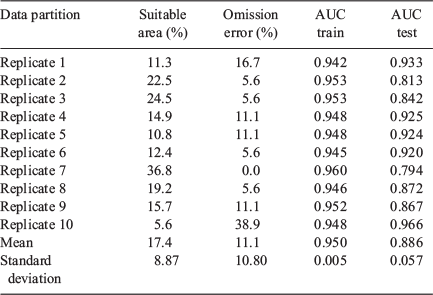
Validation of the model was accomplished using a cross-validation procedure. Specifically, 10 replicated runs were completed by splitting the occurrence data into a random subset of 10 equal-sized groups (18 training and 2 testing) that were used for model evaluation. The Area Under the Curve (AUC) of the receiver-operating characteristic plot was then calculated using each of the fitted models for both the training and testing datasets. AUC is a threshold-independent metric that evaluates the predictive performance of a model (false-positive v. true-positive) with values ranging from 0.5 to 1, where 0.5 indicates a random prediction, 1 a perfect prediction and 0.7 to 0.9 a moderate prediction (McCune and Grace 2002). The results from each of the replicated runs were also used to calculate the mean and standard deviation of the marginal effect of each environmental variable for the response curves. To evaluate the amount of area classified as suitable and the omission error rate, the probability threshold that maximised the sum of specificity and sensitivity was used.
Variable importance was estimated using a jackknife estimator based upon change in the AUC of the test data. Specifically, each environmental variable was removed from the full model one at a time and then refit using the training data to calculate the AUC based on the test data. The difference between the AUC in the full model versus the partial model represents the contribution of that variable to the overall model.
Watershed summary
As the MaxEnt analysis produced raster grids of relative suitability at the 30-m pixel resolution, the results were also summarised at a larger scale to facilitate interpretation and demonstrate applicability. The US Geological Survey (USGS) has developed a nationally consistent watershed boundary dataset (see nhd.usgs.gov/wbd.html, accessed 23 June 2017) for watersheds of various sizes. The Hydrologic Unit Code 12 (HUC12) watershed level is the smallest currently available at the national scale and generally encompasses areas on the order of 4000 to 16 000 ha. The raw MaxEnt values were summed within each HUC12 in the study area and then divided by the area of the watershed producing an area-averaged MaxEnt value. The average values were then sorted and percentiles were calculated to rank the watersheds from most suitable (i.e. 100th percentile) to least suitable. To examine the effects of the summary process, the characteristics of the watershed that had the highest average fatal burnover suitability (i.e. most dangerous) were evaluated in detail. Additionally, the calculated percentiles were compared between watersheds with and without a recorded fatal burnover to evaluate the presence of a threshold percentile.
Results
Data summary
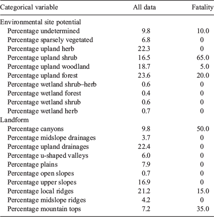
Data from 20 fatal firefighter burnover incidents that occurred between 1928 and 2009 in Southern California were compiled (Fig. 2, Table 2). The mean elevation, annual precipitation, slope steepness, and incident radiation at the sites with a fatality were higher than the mean values for Southern California as a whole, although the elevation and incident radiation values at the fatality sites were not particularly unique compared with values from across the study area (Table 3). Additionally, the fatality sites had more south-west oriented aspects (Beers’s aspect values closer to 0) and a higher proportion of sites classified as upland shrub, canyons, and mountain tops than the rest of Southern California (Table 4).

|

|

|
|
Maximum Entropy analysis
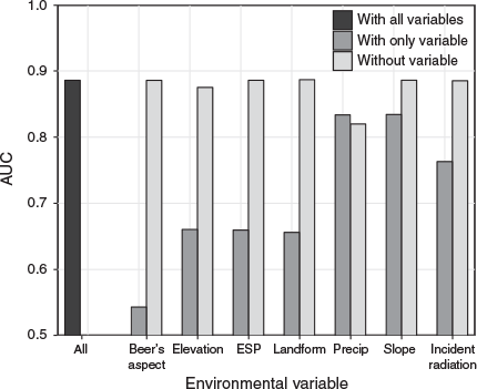
The results from the MaxEnt analysis indicated that on average ~17% of the Southern California landscape was considered suitable for a fatal firefighter burnover at the probability threshold that maximised the sum of specificity and sensitivity (Table 5). The omission error rate (percentage of presence points in areas predicted to be unsuitable) was ~11% with an average AUC, based on the test datasets, of 0.89. The locations considered most suitable for a fatal firefighter burnover were predominately located on the slopes of the Coast, Peninsular, and Transverse rangesB (Fig. 3). The jackknife procedure suggested that the annual precipitation, slope and incident radiation environmental variables had the greatest individual contributions to the MaxEnt model based upon the high AUCs obtained from models fit solely with those variables (Fig. 4).
|

|
|
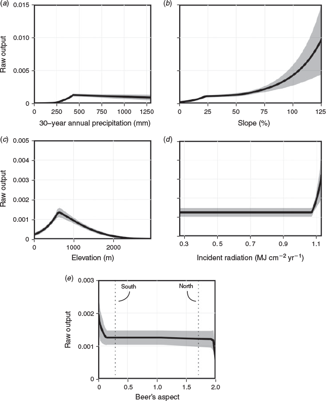
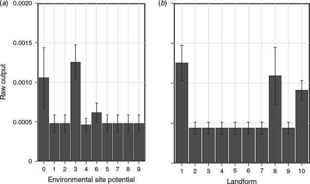
The marginal effects of the environmental variables on the suitability for a fatal firefighter burnover indicated non-linear relationships with clear inflection points at particular values (Fig. 5). The MaxEnt values were highest near 430 mm of annual precipitation, between 600 and 1000 m in elevation, and potential yearly incident radiation greater than ~1.06 MJ cm−2 year−1. Additionally, Beer’s aspects less than ~0.14 (194–256°) had the highest suitability values whereas aspects greater than 1.9 (19–71°) had the lowest suitability values. Slope steepness had a particularly dramatic effect on fatal firefighter burnover suitability with slopes greater than 75% (~37°) having an increasingly positive influence. The categorical variables also demonstrated that those areas classified as having an ESP of undetermined, upland shrub, or upland forest had a positive effect on the suitability of a fatal firefighter burnover (Fig. 6). Likewise, landforms classified as canyons, local ridges, and mountain tops also increased the suitability of a fatal burnover.
|
|
Watershed summary
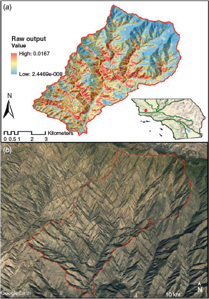
The MaxEnt results summarised and ranked by HUC12 indicated that high fatal burnover suitability (>90 percentile) was generally found in many of the watersheds located within both the Transverse and Peninsular ranges (Fig. 7). The watershed having the highest average suitability was located in Water Canyon in the Sierra Madre Mountains, north-west of Santa Barbara, CA (Fig. 8). This 4000 ha watershed is ~50 km from the Pacific Coast with an elevation ranging between 410 and 1721 m. Slopes are steep (mean 55%, ~29°), generally oriented south-west and are covered extensively by the upland shrub ESP (69%).

|
|
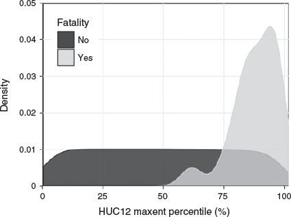
Comparisons of the watersheds that have a recorded fatality with those that did not indicated that the majority of fatalities occurred where average MaxEnt values were above the 75th percentile (Fig. 9). There were a total of 397 watersheds with average MaxEnt values above the 75th percentile.
|
Discussion
In this study we used a novel approach to identify and describe the environmental variables that affect fatal burnover suitability and where they combine to produce dangerous conditions by linking spatially explicit data with a machine-learning algorithm. Although the analysis does not directly identify cause and effect relationships between the environmental variables and the burnover incidents, it does provide a general analysis of their relative effects and the specific locations where their influence produces the greatest threat to firefighters.
Terrain influences on fatal firefighter burnovers
Slope steepness and its effect on fire behaviour is a common element described in analyses of fatal firefighter burnovers (e.g. Wilson 1977; Viegas et al. 2009; Lahaye et al. 2018). Current guidelines by the National Wildfire Coordinating Group (2014) in the US advise that firefighters should be cautious when working on or near slopes that exceed 50% (~27°). Likewise, work completed by McArthur (1967), Van Wagner (1977) and Butler et al. (2007) suggest that dramatic increases in rate of fire spread are possible when slope steepness exceeds ~35–40% (~19–22°). The results from the present study indicate that suitability for a fatal burnover is strongly related to slope steepness and that suitability increases exponentially on slopes greater than 75% (~37°). The reason for the increase in fatal burnover suitability on steep slopes is likely influenced by the associated well-documented increase in fire intensity and rate of spread related to dynamic feedbacks and non-steady behaviour as the fire rapidly accelerates uphill (Viegas 2004; Dold and Zinoviev 2009). It seems that firefighters working on steep slopes are more likely to underestimate or fail to anticipate the possible abrupt increase in fire rate of spread that is possible when the fire either moves to or spots into a position that is favourable for an upslope run. Additionally, steep slopes slow firefighter travel rates potentially compromising safety zone effectiveness (Butler et al. 2000; Alexander et al. 2005; Campbell et al. 2017). Thus, a combination of increased fire spread rate and slower firefighter travel rates likely contribute to the hazardous conditions found on steep slopes.
Terrain configuration and complexity are environmental characteristics that have previously been linked to extreme fire behaviour (Barrows 1951; Viegas and Simeoni 2011; Sharples et al. 2012). It is also an element that has been qualitatively described as important to firefighter safety because of the similarity in terrain among past fatal burnovers (see Fig. 1). Specifically, canyons or other areas, such as box canyons and gulches, that can channel winds and hot combustion products have been shown to produce non-constant fire behaviour that is enhanced by terrain curvature and positive feedbacks between the convection column and the atmosphere (Viegas and Pita 2004; Viegas and Simeoni 2011; McRae et al. 2015; Edgar et al. 2016). Viegas and Simeoni (2011) linked several fatal firefighter incidents to the presence and influence of canyons and described a variety of mechanisms attributed to the eruptive nature of fire spread in these terrain configurations. We found that half of all fatal burnovers in Southern California occurred in landforms classified as canyons, which is approximately five times higher than the proportion of the study area that contains canyons as a whole. Additionally, the MaxEnt analysis confirmed that landforms classified as canyons produced the highest fatal burnover suitability values when compared with other landform types.
Solar radiation through its effect on fuel temperature and fuel moisture is also known to have dramatic effects on wildland fire behaviour (Countryman 1966, 1977). Slopes exposed to more direct solar radiation have been shown to have warmer temperatures, lower relative humidity, and higher fire danger (Holden and Jolly 2011), which increases the potential for wildland fires to start and grow (Barrows 1951; Parisien and Moritz 2009). Additionally, fuel flammability, as modified by solar radiation, has been argued to strongly influence predictions of changing fire behaviour especially where wind, slope and preheating of fuel come into alignment (Campbell 2005; Butler 2006). The results of the present analysis confirm that locations with potential annual incident radiation values above ~1.06 MJ cm−2 year−1 have a significant positive effect on increasing the suitability of a fatal burnover. At the median latitude of Southern California these values approximately correspond to steep slopes (36–100% or 20–45° slope steepness) between south and westward oriented aspects.
Climate and fuel influences on firefighter fatalities
Several of the environmental variables, including those related to climate, vegetation, fuel and elevation, influenced fatal burnover suitability in Southern California. Specifically, those locations classified as upland shrub, with elevations between 600 and 1000 m and with an average annual precipitation near 430 mm had the highest fatal burnover suitability values. These environmental variables are all related, due to the effects of orographic lifting in coastal mountains on precipitation, subsequent evaporative fraction (Viviroli and Weingartner 2004; Anderson and Goulden 2011) and vegetation cover (Zhang et al. 2001), and approximately correspond to where Chaparral is found in Southern California (Tyrrel 1982). Chaparral tends to form dense unbroken thickets across the mountains of Southern California where the combination of an ignition with strong winds can produce large, destructive wildfires (Countryman 1974; Moritz et al. 2010). Several characteristics associated with many of the plants that compose Chaparral have been argued to contribute to their overall flammability, including high surface area to volume ratio (Countryman and Philpot 1970), low fuel moisture (Dennison and Moritz 2009) and high extractive content (Philpot 1969). Fuel types composed primarily of shrubs have also been shown to be the most dangerous in terms of the likelihood of an injury for entrapped firefighters (Page and Butler 2017).
Watershed summary
Summary of the MaxEnt results indicated that those watersheds with a recorded fatal burnover generally occurred where the average MaxEnt value exceeded the 75th percentile. There are 397 HUC12 watersheds that meet this threshold in Southern California, which are distributed mainly near the coast along the Transverse and Peninsular mountain ranges. The HUC12 with the highest average MaxEnt values confirmed the results of the smaller scale analyses in that the watershed was dominated by steep, south-west orientated slopes covered in a shrub fuel type.
Watershed boundaries are a convenient way to organise spatial data as they have consistent boundaries that are related to many of the environmental variables used in the present analysis. As shown in the Water Canyon example there is still a large amount of variability in terms of fatal burnover suitability within individual HUC12 watersheds. Summaries at finer spatial scales (e.g. HUC14 or smaller) may be appropriate to aid in the identification of specific drainages whose characteristics pose the greatest threats to firefighter safety.
Management implications
The main objective of this study was to enhance wildland firefighter situational awareness by identifying and describing the important environmental variables that are related to fatal burnovers and where their combined influence poses the greatest threat to firefighter safety. It is expected that wildland firefighters may find the maps and the ranking of the most dangerous HUC12 watersheds useful for discussion and planning purposes. For example, knowledge of the relative dangers associated with specific locations may allow firefighters to adjust incident specific strategies to avoid placing firefighters in these locations. Additionally, general fire management plans and pre-suppression plans may benefit from the identification of watersheds or other spatially defined areas (e.g. firefighter response areas) in terms of fatal burnover potential by designing suppression response protocols that avoid placing firefighters in these areas whenever possible and feasible. Although the results presented in the current study are not readily available to the average firefighter, it is hoped that the data may eventually be incorporated into existing decision support systems, such as the Wildland Fire Decision Support System (Noonan-Wright et al. 2011), in order to make the results more widely available.
It is important to recognise that particular locations or watersheds identified as having high suitability for a fatal burnover do not necessarily preclude successful fire suppression operations. It is likely that many of the most dangerous locations have had wildfires that were successfully suppressed without serious incident. However, as part of a firefighters sense-making process (Weick 1993), it is no doubt important to recognise that some locations are particularly vulnerable to eruptive type fire behaviour and share similar characteristics to past fatal firefighter burnovers. This will allow firefighters to make more informed decisions before taking action on a wildfire.
Future research
Expanding the current methodology to encompass other and larger geographic regions that have a history of fatal firefighter burnovers would potentially benefit current and future wildland firefighters. One barrier to expansion is the number of past fatal burnover incidents that have accurate location information. Recent reviews of mostly agency-produced accident investigation reports indicate that the actual locations of fatal and near-miss incidents for firefighters are rarely directly reported in the US, especially for older incidents, e.g. pre-1990s (Page and Butler 2017). Although the MaxEnt approach may only require as few as five occurrence locations (Pearson et al. 2007), thirty or more are usually recommended to produce a more accurate model (Wisz et al. 2008). Increasing the size of the study area to incorporate more occurrence locations is one possible way to address this issue, but in areas with high environmental variability or unique fire environments this trade-off may produce poor and low quality models. The inclusion of near-miss fire entrapments (i.e. non-fatal) is another option for expanding the sample population, but caution in incident selection and location determination is recommended as the details of each incident can be complex and specific to certain situations. Thus, balancing the size of the study area with the number of occurrence locations will be an important consideration for future research. Although, it is worth noting that MaxEnt models developed with low sample sizes may still be useful for defining areas ‘that have similar environmental conditions where the species is known to occur’ rather than defining the environmental requirements for a particular species range (Baldwin 2009).
The inclusion of additional environmental variables in the MaxEnt analysis may also improve future research and facilitate expansion to other geographic regions. For example, geographic areas may have well known and specific environmental factors that have affected past burnover incidents. Including those environmental variables will likely improve the resulting suitability maps. However, the environmental variables should be of a form that can be applied across the entire study area and free of or altered to deal with any temporal components. Wind speed and direction are examples of environmental variables that would seem logical to include in future analyses but because they vary substantially over time they need to be altered to deal with their temporal component, which would require additional assumptions and simplifications.
Conclusions
Developing and nurturing a culture of safety within the wildland firefighting agencies in the US and for that matter worldwide, has become a priority because of several recent fatal firefighter burnovers (TriData 1998; Alexander et al. 2012). In support of this priority, significance has been placed on leadership development, non-punitive reporting and enhancing organisational learning in order to develop a High Reliability Organisation (Black and McBride 2013). A key component of organisational learning is to analyse, report and share knowledge gained from past incidents. In this study we coupled location information from past firefighter fatalities in Southern California with geospatial environmental data to provide firefighters with specific details and locations where the variables align to increase the likelihood of a fatal burnover. Steep, south-west orientated Chaparral covered slopes in canyons were identified as particularly dangerous with ~17% of the study area classified as suitable for a fatal burnover.
Future work should consider expanding the methodology developed here to other fire prone locations in order to provide firefighters with additional site specific information related to the occurrence of fatal burnovers. Additionally, incorporation of other environmental variables may also be warranted to accommodate more localised variation in the factors that affect fatal burnover suitability.
Conflicts of interest
The authors declare that they have no conflicts of interest.
Acknowledgements
This work was supported by the Joint Fire Science Program, the National Fire Plan through the Washington Office of the Forest Service Deputy Chief for Research and the Wildland Fire Management Research Development & Application Program. We gratefully acknowledge review of the manuscript by M. E. Alexander, the Associate Editor and the anonymous reviewers, which greatly improved the manuscript.
References
Alexander ME, Baxter GJ, Dakin G (2005) Travel rates of Alberta wildland firefighters using escape routes. In ‘Eighth International Wildland Fire Safety Summit’, 26–28 April 2005, Missoula, MT, USA. (CD-ROM) (International Association of Wildland Fire: Missoula, MT, USA) Available at http://www.iawfonline.org/summit/2005%20Presentations/2005_posters/Alexander%20et%20al.pdf [Verified 18 July 2017]Alexander ME, Mutch RW, Davis KM, Bucks CM (2012) Wildland fires: dangers and survival. In ‘Wilderness Medicine’, 6th edn. (Ed. PS Auerbach) pp. 240–280. (Elsevier: Philadelphia, PA, USA)
Anderson RG, Goulden ML (2011) Relationships between climate, vegetation, and energy exchange across a montane gradient. Journal of Geophysical Research 116, G01026
| Relationships between climate, vegetation, and energy exchange across a montane gradient.Crossref | GoogleScholarGoogle Scholar |
Baldwin RA (2009) Use of maximum entropy modeling in wildlife research. Entropy (Basel, Switzerland) 11, 854–866.
| Use of maximum entropy modeling in wildlife research.Crossref | GoogleScholarGoogle Scholar |
Barrows JS (1951) Fire behavior in northern Rocky Mountain forests. USDA Forest Service, Northern Rocky Mountain Forest and Range Experiment Station, Station Paper 29. (Missoula, MT, USA) Available at https://www.treesearch.fs.fed.us/pubs/48977 [Verified 18 July 2017]
Beers TW, Dress PE, Wensel LC (1966) Aspect transformation in site productivity research. Journal of Forestry 64, 691–692.
Black AE, McBride BB (2013) Assessing high reliability practices in wildland fire management: an exploration and benchmarking of organizational culture. USDA Forest Service, Rocky Mountain Research Station, Research Note RMRS-55. (Fort Collins, CO, USA) Available at https://www.fs.fed.us/rm/pubs/rmrs_rn055.pdf [Verified 18 July 2017]
Butler BW (2006) The effect of solar irradiation on the spread rate of fires burning over a horizontal fuel array. Forest Ecology and Management 234, S84
| The effect of solar irradiation on the spread rate of fires burning over a horizontal fuel array.Crossref | GoogleScholarGoogle Scholar |
Butler BW, Bartlette RA, Bradshaw LS, Cohen JD, Andrews PL, Putnam T, Mangan RJ (1998) Fire behavior associated with the 1994 South Canyon Fire on Storm King Mountain, Colorado. USDA Forest Service, Rocky Mountain Research Station, Research Paper RMRS-9. (Ogden, UT, USA) Available at https://www.fs.fed.us/rm/pubs/rmrs_rp009.pdf [Verified 18 July 2017]
Butler BW, Cohen JD, Putnam T, Bartlette RA, Bradshaw LS (2000) A method for evaluating the effectiveness of firefighter escape routes. In ‘Proceedings of the 2000 International Wildfire Safety Summit’, 10–12 October 2000, Edmonton, AB, Canada, pp. 42–53. (International Association of Wildland Fire: Montana City, MT, USA) Available at http://cfs.nrcan.gc.ca/pubwarehouse/pdfs/33452.pdf [Verified 18 July 2017]
Butler BW, Anderson WR, Catchpole EA (2007) Influence of slope on fire spread rate. In ‘The Fire Environment—Innovations, Management, and Policy; Conference Proceedings’, 26–30 March 2007, Destin, FL, USA. (Eds BW Butler, W Cook) USDA Forest Service, Rocky Mountain Research Station, Proceedings RMRS-P-46, pp. 75–82. (Fort Collins, CO, USA) Available at https://www.treesearch.fs.fed.us/pubs/28552 [Verified 18 July 2017]
Campbell D (2005) ‘The Campbell Prediction System: a Wildland Fire Prediction and Communication System’, 3rd edn. (Ojai Print and Publishing Company: Ojai, CA, USA)
Campbell MJ, Dennison PE, Butler BW (2017) A LiDAR-based analysis of the effects of slope, vegetation density, and ground surface roughness on travel rates for wildland firefighter escape route mapping. International Journal of Wildland Fire 26, 884–895.
| A LiDAR-based analysis of the effects of slope, vegetation density, and ground surface roughness on travel rates for wildland firefighter escape route mapping.Crossref | GoogleScholarGoogle Scholar |
Cheney P, Gould J, McCaw L (2001) The Dead-Man Zone – a neglected area of firefighter safety. Australian Forestry 64, 45–50.
| The Dead-Man Zone – a neglected area of firefighter safety.Crossref | GoogleScholarGoogle Scholar |
Clements CB (2011) Effects of complex terrain on extreme fire behavior. In ‘Synthesis of Knowledge of Extreme Fire Behavior: Volume I for Fire Managers’. (Eds PA Werth, BE Potter, CB Clements, MA Finney, SL Goodrick, ME Alexander, MG Cruz, JA Forthofer, SS McAllister) USDA Forest Service, Pacific Northwest Research Station, General Technical Report PNW-854, pp. 5–23. (Portland, OR, USA)
Countryman CM (1966) The concept of the fire environment. Fire Control Notes 27, 8–10.
Countryman CM (1974) Can Southern California wildland conflagrations be stopped? USDA Forest Service, Pacific Southwest Forest and Range Experiment Station, General Technical Report PSW-7. (Berkeley, CA, USA) Available at https://www.fs.fed.us/psw/publications/documents/psw_gtr007/psw_gtr007_pp1-3.pdf [Verified 19 July 2017]
Countryman CM (1977) Radiation effects on moisture variation in ponderosa pine litter. USDA Forest Service, Pacific Southwest Forest and Range Experiment Station, Research Paper PSW-126. (Berkeley, CA, USA) Available at https://www.treesearch.fs.fed.us/pubs/29576 [Verified 18 July 2017]
Countryman CM, Philpot CW (1970) Physical characteristics of chamise as a wildland fuel. USDA Forest Service, Pacific Southwest Forest and Range Experiment Station, Research Paper PSW-66. (Berkeley, CA, USA) Available at https://www.treesearch.fs.fed.us/pubs/28638 [Verified 18 July 2017]
Countryman CM, Fosberg MA, Rothermel RC, Schroeder MJ (1968) Fire weather and fire behavior in the 1966 Loop Fire. Fire Technology 4, 126–141.
| Fire weather and fire behavior in the 1966 Loop Fire.Crossref | GoogleScholarGoogle Scholar |
Countryman CM, McCutchan MH, Ryan BC (1969) Fire weather and fire behavior at the 1968 Canyon Fire. USDA Forest Service, Pacific Southwest Forest and Range Experiment Station, Research Paper PSW-55. (Berkeley, CA, USA) Available at https://www.fs.fed.us/psw/publications/documents/psw_rp055/psw_rp055.pdf [Verified 17 August 2017]
Dennison PE, Moritz MA (2009) Critical live fuel moisture in chaparral ecosystems: a threshold for fire activity and its relationship to antecedent precipitation. International Journal of Wildland Fire 18, 1021–1027.
| Critical live fuel moisture in chaparral ecosystems: a threshold for fire activity and its relationship to antecedent precipitation.Crossref | GoogleScholarGoogle Scholar |
Dold JW, Zinoviev A (2009) Fire eruption through intensity and spread rate interaction mediated by flow attachment. Combustion Theory and Modelling 13, 763–793.
| Fire eruption through intensity and spread rate interaction mediated by flow attachment.Crossref | GoogleScholarGoogle Scholar |
Edgar RA, Sharples JJ, Sidhu HS (2016) Examining the effects of convective intensity on plume attachment in three-dimensional trenches. In ‘Chemeca 2016: Chemical Engineering – Regeneration, Recovery and Reinvention’, 25–28 September 2016, Melbourne, Vic., Australia. pp. 613–621. (Engineers Australia: Barton, ACT, Australia)
Elith J, Phillips SJ, Hastie T, Dudík M, Chee YE, Yates CJ (2011) A statistical explanation of MaxEnt for ecologists. Diversity & Distributions 17, 43–57.
| A statistical explanation of MaxEnt for ecologists.Crossref | GoogleScholarGoogle Scholar |
Gallacher JR, Ripa B, Butler BW, Fletcher TH (2018) Lab-scale observations of flame attachment on slopes with implications for firefighter safety zones. Fire Safety Journal 96, 93–104.
| Lab-scale observations of flame attachment on slopes with implications for firefighter safety zones.Crossref | GoogleScholarGoogle Scholar |
Hernandez PA, Graham CH, Master LL, Albert DL (2006) The effect of sample size and species characteristics on performance of different species distribution modeling methods. Ecography 29, 773–785.
| The effect of sample size and species characteristics on performance of different species distribution modeling methods.Crossref | GoogleScholarGoogle Scholar |
Holden ZA, Jolly WM (2011) Modeling topographic influences on fuel moisture and fire danger in complex terrain to improve wildland fire management decision support. Forest Ecology and Management 262, 2133–2141.
| Modeling topographic influences on fuel moisture and fire danger in complex terrain to improve wildland fire management decision support.Crossref | GoogleScholarGoogle Scholar |
Horn BK (1981) Hill shading and the reflectance map. Proceedings of the IEEE 69, 14–47.
| Hill shading and the reflectance map.Crossref | GoogleScholarGoogle Scholar |
Hughes M, Hall A (2010) Local and synoptic mechanisms causing Southern California’s Santa Ana winds. Climate Dynamics 34, 847–857.
| Local and synoptic mechanisms causing Southern California’s Santa Ana winds.Crossref | GoogleScholarGoogle Scholar |
Jahns RH (1954) ‘Geology of Southern California.’ (State of California, Department of Natural Resources: Davis, CA, USA)
Jenness J (2006) Topographic Position Index (tpi_jen.avx) extension for ArcView 3.x., Jenness Enterprises. Available at http://www.jennessent.com/arcview/tpi.htm [Verified 18 July 2017]
Jiménez-Valverde A, Lobo JM, Hortal J (2008) Not as good as they seem: the importance of concepts in species distribution modelling. Diversity & Distributions 14, 885–890.
| Not as good as they seem: the importance of concepts in species distribution modelling.Crossref | GoogleScholarGoogle Scholar |
Keeley JE (2006) Fire management impacts on invasive plants in the western United States. Conservation Biology 20, 375–384.
| Fire management impacts on invasive plants in the western United States.Crossref | GoogleScholarGoogle Scholar |
Keeley JE, Keeley SC (1981) Post-fire regeneration of Southern California chaparral. American Journal of Botany 68, 524–530.
| Post-fire regeneration of Southern California chaparral.Crossref | GoogleScholarGoogle Scholar |
Lahaye S, Sharples J, Matthews S, Heemstra S, Price O, Badlan R (2018) How do weather and terrain contribute to firefighter entrapments in Australia? International Journal of Wildland Fire 27, 85–98.
| How do weather and terrain contribute to firefighter entrapments in Australia?Crossref | GoogleScholarGoogle Scholar |
Maclean JN (2013) ‘The Esperanza Fire: Arson, Murder, and the Agony of Engine 57.’ (Counterpoint Press: Berkeley, CA, USA)
McArthur AG (1967) Fire behaviour in eucalypt forests. Department of National Development, Forestry and Timber Bureau Leaflet 107. (Canberra, ACT, Australia)
McCune B, Grace J (2002) ‘Analysis of Ecological Communities.’ (MJM Sofware Design: Glenden Beach, OR, USA)
McCune B, Keon D (2002) Equations for potential annual direct incident radiation and heat load. Journal of Vegetation Science 13, 603–606.
| Equations for potential annual direct incident radiation and heat load.Crossref | GoogleScholarGoogle Scholar |
McRae RHD, Sharples JJ, Fromm M (2015) Linking local wildfire dynamics to pyroCb development. Natural Hazards and Earth System Sciences 15, 417–428.
| Linking local wildfire dynamics to pyroCb development.Crossref | GoogleScholarGoogle Scholar |
Merow C, Smith MJ, Silander JA (2013) A practical guide to MaxEnt for modeling species’ distributions: what it does, and why inputs and settings matter. Ecography 36, 1058–1069.
| A practical guide to MaxEnt for modeling species’ distributions: what it does, and why inputs and settings matter.Crossref | GoogleScholarGoogle Scholar |
Moritz MA, Moody TJ, Krawchuk MA, Hughes M, Hall A (2010) Spatial variation in extreme winds predicts large wildfire locations in chaparral ecosystems. Geophysical Research Letters 37, L04801
| Spatial variation in extreme winds predicts large wildfire locations in chaparral ecosystems.Crossref | GoogleScholarGoogle Scholar |
National Wildfire Coordinating Group (2007) Leading in the wildland fire service. National Interagency Fire Center, PMS 494–2, NFES 2889. (Boise, ID, USA)
National Wildfire Coordinating Group (2014) Incident response pocket guide. National Interagency Fire Center, PMS 461, NFES 001077. (Boise, ID, USA)
Noonan-Wright EK, Opperman TS, Finney MA, Zimmerman GT, Seli RC, Elenz LM, Calkin DE, Fiedler JR (2011) Developing the US Wildland Fire Decision Support System. Journal of Combustion 2011, art168473
| Developing the US Wildland Fire Decision Support System.Crossref | GoogleScholarGoogle Scholar |
Page WG, Butler BW (2017) An empirically based approach to defining wildland firefighter safety and survival zone separation distances. International Journal of Wildland Fire 26, 655–667.
| An empirically based approach to defining wildland firefighter safety and survival zone separation distances.Crossref | GoogleScholarGoogle Scholar |
Parisien MA, Moritz MA (2009) Environmental controls on the distribution of wildfire at multiple spatial scales. Ecological Monographs 79, 127–154.
| Environmental controls on the distribution of wildfire at multiple spatial scales.Crossref | GoogleScholarGoogle Scholar |
Parisien MA, Snetsinger S, Greenberg JA, Nelson CR, Schoennagel TL, Dobrowski SZ, Moritz MA (2012) Spatial variability in wildfire probability across the western United States. International Journal of Wildland Fire 21, 313–327.
| Spatial variability in wildfire probability across the western United States.Crossref | GoogleScholarGoogle Scholar |
Paysen TE, Cohen JD (1990) Chamise chaparral dead fuel fraction is not reliably predicted by age. Western Journal of Applied Forestry 5, 127–131.
Pearson RG, Raxworthy CJ, Nakamura M, Peterson AT (2007) Predicting species distributions from small numbers of occurrence records: a test case using cryptic geckos in Madagascar. Journal of Biogeography 34, 102–117.
| Predicting species distributions from small numbers of occurrence records: a test case using cryptic geckos in Madagascar.Crossref | GoogleScholarGoogle Scholar |
Phillips SJ, Anderson RP, Schapire RE (2006) Maximum entropy modeling of species geographic distributions. Ecological Modelling 190, 231–259.
| Maximum entropy modeling of species geographic distributions.Crossref | GoogleScholarGoogle Scholar |
Philpot CW (1969) Seasonal changes in heat content and ether extractive content of chamise. USDA Forest Service, Intermountain Forest and Range Experiment Station, Research Paper INT-61. (Ogden, UT, USA)
Rollins MG (2009) LANDFIRE: a nationally consistent vegetation, wildland fire, and fuel assessment. International Journal of Wildland Fire 18, 235–249.
| LANDFIRE: a nationally consistent vegetation, wildland fire, and fuel assessment.Crossref | GoogleScholarGoogle Scholar |
Rothermel RC (1985) Fire behavior considerations of aerial ignition. In ‘Prescribed Fire by Aerial Ignition, Proceedings of a Workshop’, 30 October–1 November 1984, Missoula, MT, USA. (Ed. RW Mutch) pp. 143–158. (Intermountain Fire Council: Missoula, MT, USA) Available at https://www.frames.gov/documents/behaveplus/publications/Rothermel_1984_AerialIgnition_ocr.pdf [Verified 17 August 2017]
Rothermel RC (1993) Mann Gulch Fire: a race that couldn’t be won. USDA Forest Service, Intermountain Research Station, General Technical Report INT-299. (Ogden, UT, USA)
Rothermel RC, Philpot CW (1973) Predicting changes in chaparral flammability. Journal of Forestry 71, 640–643.
Schoenherr AA (1995) ‘A Natural History of California.’ (University of California Press: Berkeley, CA, USA)
Schroeder MJ, Buck CC (1970) Fire weather. USDA Forest Service, Agricultural Handbook 360. (Washington, DC, USA)
Shannon CE (1948) A mathematical theory of communication. The Bell System Technical Journal 27, 379–423, 623–656.
| A mathematical theory of communication.Crossref | GoogleScholarGoogle Scholar |
Sharples JJ, Gill AM, Dold JW (2010) The trench effect and eruptive wildifres: lessons from the King’s Cross Underground disaster. In ‘Proceedings of Australian Fire and Emergency Service Authorities Council 2010 Conference’, 8–10 September 2010, Darwin, NT, Australia. (Australian Fire and Emergency Service Authorities Council: Darwin, NT, Australia) Available at http://www.maths.manchester.ac.uk/~jwd/articles/10-TEaEW.pdf [Verified 11 January 2018]
Sharples JJ, McRae RHD, Wilkes SR (2012) Wind-terrain effects on the propagation of wildfires in rugged terrain: fire channelling. International Journal of Wildland Fire 21, 282–296.
| Wind-terrain effects on the propagation of wildfires in rugged terrain: fire channelling.Crossref | GoogleScholarGoogle Scholar |
Simcox S, Wilkes NS, Jones IP (1992) Computer simulation of the flows of hot gases from the fire at King’s Cross Underground Station. Fire Safety Journal 18, 49–73.
| Computer simulation of the flows of hot gases from the fire at King’s Cross Underground Station.Crossref | GoogleScholarGoogle Scholar |
Smith A, Page B, Duffy K, Slotow R (2012) Using Maximum Entropy modeling to predict the potential distributions of large trees for conservation planning. Ecosphere 3, art56
| Using Maximum Entropy modeling to predict the potential distributions of large trees for conservation planning.Crossref | GoogleScholarGoogle Scholar |
Sugihara NG, van Wagtendonk JW, Fites-Kaufman J, Shaffer KE, Thode AE (2006) ‘Fire in California’s ecosystems.’ (University of California Press: Berkeley, CA, USA)
TriData (1998) Wildland firefighter safety awareness study: phase 3 – implementing cultural changes for safety. (TriData Corporation: Arlington, VA, USA) Available at http://www.wildfirelessons.net/viewdocument/wildland-firefighter-safety-awarene [Verified 18 July 2017]
Tyrrel RR (1982) Chaparral in Southern California. In ‘Symposium on Dynamics and Management of Mediterranean-type Ecosystems’, 22–26 June 1981, San Diego, CA, USA. (Eds CE Conrad, WC Oechel) USDA Forest Service, Pacific Southwest Forest and Range Experiment Station, General Technical Report PSW-58, pp. 56–59. (Berkeley, CA, USA)
USDA Forest Service (1957) The Inaja forest fire disaster. (US Department of Agriculture, Forest Service: Washington, DC, USA) Available at http://www.wlfalwaysremember.org/images/incidents/documents/1956-11-25-inaja-report.pdf [Verified 17 August 2017]
Van Wagner CE (1977) Effect of slope on fire spread rate. Canadian Forestry Service Bi-monthly Research Notes 33, 7–8.
Viegas DX (2004) On the existence of a steady state regime for slope and wind driven fires. International Journal of Wildland Fire 13, 101–117.
| On the existence of a steady state regime for slope and wind driven fires.Crossref | GoogleScholarGoogle Scholar |
Viegas DX, Pita LP (2004) Fire spread in canyons. International Journal of Wildland Fire 13, 253–274.
| Fire spread in canyons.Crossref | GoogleScholarGoogle Scholar |
Viegas DX, Simeoni A (2011) Eruptive behaviour of forest fires. Fire Technology 47, 303–320.
| Eruptive behaviour of forest fires.Crossref | GoogleScholarGoogle Scholar |
Viegas DX, Simeoni A, Xanthopoulos G, Rossa C, Ribeiro LM, Pita LP, Stipanicev D, Zinoviev A, Weber R, Dold J, Caballero D, San Miguel J (2009) ‘Recent Forest Fire Related Accidents in Europe.’ (Office for Official Publications of the European Communities: Luxembourg)
Viviroli D, Weingartner R (2004) The hydrological significance of mountains: from regional to global scale. Hydrology and Earth System Sciences 8, 1017–1030.
| The hydrological significance of mountains: from regional to global scale.Crossref | GoogleScholarGoogle Scholar |
Weick KE (1993) The collapse of sensemaking in organizations: the Mann Gulch disaster. Administrative Science Quarterly 38, 628–652.
| The collapse of sensemaking in organizations: the Mann Gulch disaster.Crossref | GoogleScholarGoogle Scholar |
Weise DR, Biging GS (1996) Effects of wind velocity and slope on flame properties. Canadian Journal of Forest Research 26, 1849–1858.
| Effects of wind velocity and slope on flame properties.Crossref | GoogleScholarGoogle Scholar |
Wilson CC (1977) Fatal and near-fatal forest fires: the common denominators. The International Fire Chief 43, 9–10. , 12–15.
Wisz MS, Hijmans RJ, Li J, Peterson AT, Graham CH, Guisan A, NCEAS Predicting Species Distributions Working Group (2008) Effects of sample size on the performance of species distribution models. Diversity & Distributions 14, 763–773.
| Effects of sample size on the performance of species distribution models.Crossref | GoogleScholarGoogle Scholar |
Zhang L, Dawes WR, Walker GR (2001) Response of mean annual evapotranspiration to vegetation changes at catchment scale. Water Resources Research 37, 701–708.
| Response of mean annual evapotranspiration to vegetation changes at catchment scale.Crossref | GoogleScholarGoogle Scholar |
A In this paper Southern California includes the following 10 counties: Imperial, Kern, Los Angeles, Orange, Riverside, San Bernardino, San Diego, San Luis Obispo, Santa Barbara and Ventura.
B Contact the authors to request the raw MaxEnt output raster dataset.