

High wildfire damage in interface communities in California
Heather Anu Kramer A D , Miranda H. Mockrin B , Patricia M. Alexandre C and Volker C. Radeloff A
A SILVIS Lab, Department of Forest and Wildlife Ecology, University of Wisconsin–Madison, 1630 Linden Drive, Madison, WI 53706, USA.
B Northern Research Station, USDA Forest Service, 5523 Research Park Drive Suite, 350 Baltimore, MD 21228, USA.
C Forest Research Centre, School of Agriculture, University of Lisbon, Tapada da Ajuda, 1349-017 Lisboa, Portugal.
D Corresponding author. Email: hakramer@wisc.edu
International Journal of Wildland Fire 28(9) 641-650 https://doi.org/10.1071/WF18108
Submitted: 14 July 2018 Accepted: 24 June 2019 Published: 30 July 2019
Journal compilation © IAWF 2019 Open Access CC BY-NC-ND
Abstract
Globally, and in the US, wildfires pose increasing risk to people and their homes. Wildfire management assumes that buildings burn primarily in the wildland–urban interface (WUI), where homes are either ignited directly (especially in intermix WUI areas, where houses and wildland fuels intermingle), or via firebrands, the main threat to buildings in the interface WUI (areas with minimal wildland fuel, yet close to dense wildland vegetation). However, even urban areas can succumb to wildfires. We examined where wildfire damages occur among urban, rural and WUI (intermix and interface) areas for approximately three decades in California (1985–2013). We found that interface WUI contained 50% of buildings destroyed by wildfire, whereas intermix WUI contained only 32%. The proportion of buildings destroyed by fires among classes was similar, though highest in interface WUI areas (15.6%). Our results demonstrate that the interface WUI is where most buildings were destroyed in California, despite less wildland fuel. Continued advancement of models, mitigation and regulations tailored for the interface WUI, both for California and elsewhere, will complement the prior focus on the intermix WUI.
Additional keywords: destruction, hazard, housing loss, plan, policy, wildland–urban interface.
Introduction
Over the past several decades, catastrophic wildfires have caused mounting economic, social and ecological damage across the globe (Moritz et al. 2014; Bowman et al. 2017). For example, Australia, Canada, Portugal and Chile have all seen record destruction and loss of life due to wildfire in recent years (Godoy et al. 2019; Cruz et al. 2012; Gómez-González et al. 2018; Oliveira et al. 2017; Boulianne et al. 2018). The United States is similarly incurring high rates of wildfire damage, despite soaring expenditures on wildfire management (Fischer et al. 2016; Steelman 2016). For example, in 2018 the Camp fire destroyed nearly 19 000 structures and killed 85 people – the deadliest fire in California history (CAL FIRE 2018b, 2018c).
In California, and the rest of the USA, wildfire management has become more complex, costly and dangerous as a result of multiple factors, including climate change, legacies of wildfire suppression and housing growth (Fischer et al. 2016; Steelman 2016). One-third of all homes in the US are built in or near wildland vegetation and constitute the wildland–urban interface, or WUI, a complex environment that increases the challenges of wildfire management (Schoennagel et al. 2017; Radeloff et al. 2018). Because ignitions are overwhelmingly human-caused (Nagy et al. 2018), wildfire ignitions are more likely with WUI expansion (Syphard et al. 2007; Syphard et al. 2017) and even more so as the entire wildfire season lengthens owing to more ignitions and climate change (Balch et al. 2017; Schoennagel et al. 2017). At the same time, there are more homes to protect in the event of wildfire (Radeloff et al. 2018), resulting in greater wildfire suppression expenditures (Gude et al. 2013; Hand et al. 2016). Indeed, 69% of buildings destroyed by wildfire across the US are located in the WUI, and in California, that number rises to 75% (Kramer et al. 2018).
Accordingly, wildfire policy and recommendations often focus on the WUI and aim to reduce building ignition either from nearby vegetation or from firebrands (United States Congress 2003; Wildland Fire Executive Council 2014). For example, a recent presidential Executive Order intended to reduce the likelihood of wildfire risk to federal buildings through retrofitting and maintaining defensible space (Obama 2016). However, beyond these federal buildings, the US federal government does not regulate or influence land-use planning and building practices in response to wildfire hazards (as opposed to other natural hazards such as floods) (Burby 2001; Thomas and Leichenko 2011). Instead, the responsibility for adapting residential development to wildfire falls to local governments and communities. For example, city or county governments can use land-use regulations to guide or restrict residential development to reduce risk of wildfire loss, and incorporate wildfire risk into community planning (Fire Adapted Communities Coalition 2014; FAC Learning Network 2016). At the level of the individual home, mitigation through building materials or vegetation can be required by building codes, overlay zoning, and other ordinances or regulations (Winter et al. 2009; McCaffrey et al. 2011). Voluntary efforts and education programs are also widespread (Kramer et al. 2018), such as the Firewise program, which provides homeowners with recommendations on how to reduce risk from wildfires through mitigation (National Fire Protection Association 2016).
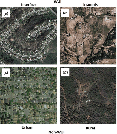
Management efforts commonly focus on all types of WUI uniformly, or define it loosely or with inconsistent definitions (Platt 2010). The 2001 Federal Register definition of the WUI defines two separate types of WUI: interface WUI (Fig. 1a), i.e. developed areas that have sparse or no wildland vegetation, but are within close proximity of a large patch of wildland, and intermix WUI (Fig. 1b), i.e. the area where houses and wildland vegetation directly intermingle (USDA and USDI 2001). Both types of WUI have been widely mapped (Radeloff et al. 2005; Radeloff et al. 2018), based on the specifications of the Federal Register WUI definition (USDA and USDI 2001). These maps are used to inform federal policy, including a recent Executive Order (Obama 2016).
|
Within this WUI framework, the intermix WUI is often described as more difficult to manage for wildland fire (Davis et al. 2000). Indeed, the designation of intermix vs interface WUI implies that there is less flammable vegetation in the interface WUI. However, landscaping does not constitute a ‘wildland fuel’, yet can carry fire, and, in the case of certain fire-prone varieties such as eucalyptus, cypress and juniper, can propagate fire more rapidly than native fuels (CAL FIRE 2017). Among the two WUI types, there are far more houses in the interface WUI, but the intermix WUI is far more widespread (Radeloff et al. 2018), and eight times more prevalent in area within destructive wildfires in the US (Kramer et al. 2018). However, interface WUI, and even urban areas, can also experience devastating losses from wildfires. For example, the 2017 Tubbs fire in California caused major damage within the city limits of Santa Rosa, where it destroyed entire urban neighbourhoods and 5636 buildings, making it one of the most destructive wildfires in US history. Furthermore, recent work by Syphard et al. (2019) suggests that rural destruction was high in a sample of fires throughout California, further fuelling the debate on housing density and wildfire destruction. A further incongruence exists between research, which focuses more on the WUI, and management and legislation, which in California is often based on mapped Fire Hazard Severity Zones, which only peripherally consider the WUI (Davis et al. 2000; CAL FIRE 2007).
An enhanced understanding of where wildfire losses occur, within and beyond the WUI, could help refine management recommendations. Although houses in the intermix WUI can be directly ignited from nearby wildland vegetation, other buildings, or firebrands (burning material that can be carried aloft), direct ignition from nearby wildland vegetation in the interface WUI is less common (because interface areas are defined by having lower densities of wildland vegetation), and firebrands, landscaping vegetation and other buildings are a more common source of ignition (Stewart et al. 2007; Haas et al. 2013). In other words, the two types of WUI may require different management approaches. For example, maintaining defensible space and reducing fuel loads over large landscapes may be more effective in reducing wildfire losses in the intermix WUI than the interface WUI. Furthermore, fuel models and wildland fire behaviour models are lacking for areas with an abundance of non-natural fuel such as propane tanks, vehicles and the homes themselves, as is commonly the case in urban and interface WUI areas (Anderson 1982; Scott and Burgan 2005; Maranghides and Mell 2012).
Our overarching research question was thus to determine the extent of wildfire destruction associated with different residential development settings (urban, interface WUI, intermix WUI and rural, as defined by the Federal Register (USDA and USDI 2001) and mapped by Radeloff et al. (2005)) in California – the state with both the most building destruction in the WUI, as well as the most building destruction from wildfire across the US (Kramer et al. 2018). We examined wildfires across California over a 28-year period (1985–2013) and include the 2017 Tubbs fire as a recent case study of a notably destructive and urban wildfire in order to fully characterise the challenges wildfire poses to homes and buildings in this densely developed and fire-prone state. Our research questions were: (1) how are building losses distributed between intermix WUI, interface WUI, non-WUI urban and non-WUI rural areas; and (2) do these patterns of building losses vary with the destructiveness (defined as the total number of buildings destroyed) of the wildfire, and among individual wildfires? We expected both the total number of buildings destroyed and the rate of destruction to be higher in the intermix WUI than the interface WUI because (i) the interface WUI is smaller in area than the intermix WUI, (ii) firebrands, other buildings and landscaped vegetation are the main source of ignitions in the interface WUI, and (iii) dense wildland vegetation is mixed with buildings in the intermix WUI.
Methods
Study area
California is an apt location for our study. Owing to the abundance of wildfires and close proximity of people and wildfire-prone landscapes, the state has a long history of destructive wildfires. Between 2000 and 2013, more buildings were destroyed by wildfire in California than in the other 47 conterminous US states combined (Kramer et al. 2018). Hundreds of millions of dollars are spent each year on suppression alone, on top of costs for mitigation, education and research into ways people and wildfire can coexist (California Department of Forestry and Fire Protection 2017). The state is highly diverse in climate, vegetation, topography, land ownership, and development densities and patterns. California’s natural systems range from chaparral, most prominent in the south coast bioregion, redwood on the central coast, to oak woodland in the central coast and in a band across lower elevations of the Sierra Nevada, with mixed-conifer and alpine systems at higher elevations in this bioregion (Sugihara et al. 2006). Building settlement patterns are also highly diverse, with large urban centres, both widespread interface and intermix WUI, and large swathes of rural and agricultural lands. Furthermore, human communities vary broadly in income and socioeconomic status across the state, with high racial and ethnic diversity (US Census Bureau 2018). Wildfires that destroy buildings occur throughout California, and although most wildfires that destroy many buildings have affected southern California, the three most destructive wildfires (in terms of building loss) in state history, the 2018 Camp fire, 2017 Tubbs fire and 1991 Oakland Hills fire, occurred in the northern half of the state (CAL FIRE 2018c).
Data
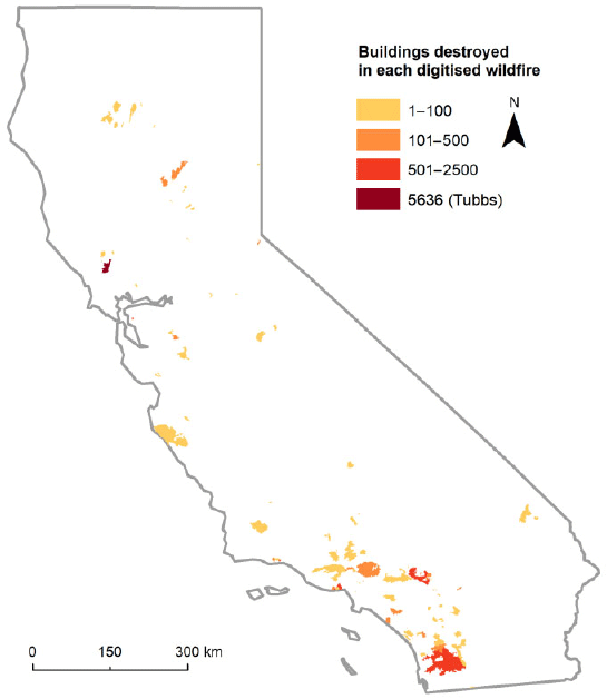
To determine the locations of buildings destroyed by wildfire, we digitised all buildings before and after all wildfires that burned between 1985 and 2013 that contained at least one building and for which there was sufficient imagery (Fig. 2). Of 270 wildfires considered, 89 destroyed at least one building. Data collection methods for the post-2000 wildfires (n = 78) are described by Alexandre et al. (2015) and methods for the pre-2000 wildfires (n = 11) are described by Kramer et al. (2018), which also includes an accuracy assessment for wildfires from 2000 to 2013. Although methods are similar for these two datasets, image availability was more limited for older fires. We used wildfire perimeters from the Monitoring Trends in Burn Severity (MTBS) dataset, which includes all wildfires greater than 404 ha (1000 acres) in the western US (Monitoring Trends in Burn Severity 2016).
|
As a case study, we acquired data on building location and destruction status in the 2017 Tubbs fire. The wildfire perimeter was obtained from CAL FIRE (2018a). Building locations were composed of points from two sources. CAL FIRE provided point data for all 5636 destroyed buildings, as well as for damaged and surviving buildings, which we combined into a single non-destroyed class (n = 371) (CAL FIRE and Kephart 2018). Because some surviving buildings were skipped in the rapid post-fire assessment, and did not appear in the CAL FIRE database, we used Sonoma County building footprints derived from LiDAR flown in 2013 (Sonoma County Agricultural Preservation and Open Space District 2018) to supplement the surviving buildings dataset, adding (2519) additional surviving building points at the centroids of all footprint polygons with perimeters that were >5 m from a CAL FIRE building point. Although this approach does not account perfectly for every building within the fire perimeter, quality check assured us that the accuracy was sufficient for the purpose of the present case study.
For all wildfires studied, we used the 1990, 2000 and 2010 WUI classifications created by Radeloff et al. (2018) to identify interface WUI, intermix WUI, urban and rural areas. WUI areas were defined as census blocks with at least 6.17 homes km−2 and either (1) 50% wildland vegetation within the census block – classified as intermix WUI; or (2) a large (at least 5 km2) area of dense wildland vegetation (at least 75%), within 2.4 km (based on the distance firebrands may travel) – classified as interface WUI. These WUI types and thresholds are based on the 2001 Federal Register definition of the WUI (USDA and USDI 2001; Radeloff et al. 2005). Non-WUI areas were classified as urban, i.e. those with ≥6.17 homes km−2 but with insufficient vegetation, even nearby, to be classified as WUI, or rural, i.e. those with <6.17 homes km−2 and with either wildland vegetation or not. We applied the 1990 WUI map to wildfires that burned between 1985 and 1994, the 2000 WUI map to wildfires that burned between 1995 and 2004, and the 2010 WUI map to wildfires that burned between 2005 and 2013, as well as to the Tubbs fire case study.
What is the distribution of building destruction in WUI and non-WUI classes?
We calculated the area burned and buildings destroyed within interface WUI, intermix WUI, non-WUI urban and non-WUI rural for all wildfires in our dataset that burned at least one building between 1985 and 2013. We summarised the percentage of each wildfire area in each class, where class represents urban, interface WUI, intermix WUI and rural areas. We also calculated the proportion of total destruction and destruction rate as follows:


P(dc) = proportion of total destruction in a given class
Rc = destruction rate for a given class
Dc = number of buildings destroyed in a given class
Dt = total number of buildings destroyed
Sc = number of buildings that survived in a given class
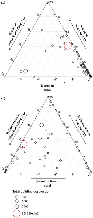
We present findings for all wildfires together, as well as ternary plots to examine variation among individual wildfires. Ternary plots show each point as a position within a triangle, where each side of the triangle forms an axis that ranges from 0 to 100, and for which the three values for each point must sum to 100. As ternary plots have, by definition, three axes, we combined urban and interface WUI into a single axis (the urban area was small and had little destruction). Intermix WUI and rural areas were represented by the other two axes. We created two ternary plots showing how the (1) proportion of area, and (2) proportion of destruction in each class varied among fires and by fire size.
How does overall wildfire destruction of buildings affect the distribution of building destruction and area in WUI and non-WUI classes?
We compared the building destruction and wildfire area in urban, interface WUI, intermix WUI and rural areas with the overall destructiveness of the 89 fires in our dataset. We summarised these relationships in scatterplots with Pearson correlation coefficients. We performed an exploratory analysis of how destruction rate changed over time in each WUI and non-WUI class using linear models, yet we caution that our data for older fires is a small subset that may not capture some trends (see Part 4 in Supplementary material available online). Because of this difference in data availability for older fires, we did not perform an analysis of absolute destruction. We also describe the 2017 Tubbs fire as a case study, which was the most destructive California wildfire (destroyed the most buildings) at that time. See Table A1.1 in Supplementary material for full table of wildfire area, destruction and survival.
Robustness checks and caveats
Interface and intermix areas, by definition, differ in their residential density and distribution of vegetation. Therefore, we conducted an additional exploratory analysis to test whether building density was significantly related to building survival. We compared the distance from each building to the nearest building, nearest destroyed building and nearest surviving building in urban areas, interface WUI, intermix WUI and rural areas to see if our findings on building loss followed from the spatial configuration of buildings within these different settings (see Part 2 in Supplementary material). Because buildings themselves often serve as fuel, we expected shorter distances between destroyed buildings in urban and interface WUI areas compared with buildings that survived. Although further investigation of building proximity to burned vegetation or high-severity fire would be valuable, such data collection was out of the scope of this study.
Because we used a national WUI map to investigate wildfire losses and policy, we also examined the state-level policy designations unique to California. California requires wildfire mitigation in designated hazard areas, as mapped by CAL FIRE (Davis et al. 2000; CAL FIRE 2007). Starting in the 1980s, regulations for mitigation (building materials and defensible space) by wildfire hazard zones were first adopted for State Responsibility Areas (SRAs), i.e. areas where the State of California (CAL FIRE) has the responsibility for suppression. After the catastrophic Oakland Hills fire (Tunnel fire) of 1991, hazard zoning and mitigation requirements were expanded to Local Responsibility Areas (LRAs), which includes incorporated cities, densely populated areas and agricultural lands (1992 Bates Bill (California State Assembly 1992); CAL FIRE 2018a). Because the efficacy of state-level hazard classifications has been questioned in the past (Syphard et al. 2012), we examined destruction within these zones for all wildfires (see Part 3 in Supplementary material).
Results
What is the distribution of building destruction in WUI and non-WUI classes?
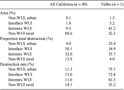
From 1985 to 2013, we mapped 8722 buildings destroyed by wildfire in 89 individual wildfires that destroyed at least one building, an overall destruction rate of 14% of all buildings threatened by these fires. Although only 32% of buildings in California are located in the WUI, 82% of the destroyed buildings were located in the WUI (Table 1).

|
Nearly all the area within wildfire perimeters was rural (89%), yet these rural areas contained only 14% of the buildings that were destroyed (Table 2; Fig. 3). Interface WUI accounted for 50% of all buildings destroyed, despite covering only 1.8% of the total area burned and comprising only 27% of buildings in California (Table 1, Table 2). The destruction rate was also highest in the interface WUI (15.6% of all interface buildings within fire perimeters were destroyed; Table 2), though destruction rates were similar across urban, interface WUI, intermix WUI and rural areas (11.3, 15.6, 11.6 and 14.1% respectively; Table 1). Ternary plots examined variation in destruction and WUI classes among individual wildfires. Nearly all of the wildfires occurred primarily in rural areas, but rural destruction was variable (Table 2; Fig. 3b). For example, although rural areas accounted for only 14% of all destroyed buildings (of all fires combined), 44 of 89 individual wildfires experienced more building destruction in rural areas than all other areas combined, although the total number of buildings in these wildfires was low (these 44 wildfires only accounted for 632 (7.2%) buildings destroyed; Fig. 3b; Table A1.1).
|
|
How does overall wildfire destruction of buildings affect the distribution of building destruction and area in WUI and non-WUI classes?
More destructive fires threatened and destroyed a higher proportion of buildings in the interface WUI and fewer in rural areas (Fig. 4). Destruction rate in more destructive wildfires was higher in urban, interface WUI and intermix WUI areas, yet destruction rate in rural areas was not related to the fire’s overall destruction (Fig. 4). However, more destructive wildfires had a substantially higher proportion of area in interface WUI and lower proportion of rural area (Fig. 4). Destruction rate did not significantly change over time, either for all fires, or for any individual WUI or non-WUI class (Part 4 in Supplementary material).

|
In the Tubbs fire, similar to other California wildfires, destruction was primarily in the WUI (71 and 82% destruction respectively; Table 2). Although more destructive fires showed a higher proportion of destruction in the interface WUI, the Tubbs fire had approximately equal destruction in the interface and intermix WUI (35 and 36% respectively; Table 2). However, 1/4 of destruction in the Tubbs fire occurred in urban areas, compared with 4% for California fires (Table 2). Indeed, only 5 fires in our dataset of 89 had any destruction at all in urban areas, totalling 349 buildings, compared with 1430 urban buildings destroyed in the Tubbs fire alone (Table A1.1). The destruction rate was also very high in the Tubbs fire across urban areas, as well as interface and intermix WUI (76, 72 and 62% respectively), matching trends of higher destruction rates in more destructive fires (Fig. 4).
Robustness checks and caveats
Our exploratory analysis of building proximity and destruction revealed high variability. Although destroyed buildings were generally closer to other destroyed buildings than surviving buildings, this relationship was not significant (owing to high variability in distances). There was no significant difference among distances between buildings for the WUI and non-WUI types (see Part 2 in Supplementary material).
Fire Hazard Severity Zones accurately matched area burned and destruction rate in most wildfires, with the exception of the Tubbs fire. Of all area burned by destructive wildfires in our sample, 86% fell into the Very High hazard class and captured 78% of destruction. Destruction rates were highest for High and Very High classes (13% in both; see Part 3 in Supplementary material). In contrast, the Tubbs fire burned the most area (51%) in Moderate zones and the most buildings (39%) in Urban (unrated) areas, where destruction rate was also the highest (73%; see Part 3 in Supplementary material).
Discussion
Interface WUI areas accounted for the majority of building destruction in California wildfires that destroyed at least one building. In fires with more overall building destruction, the percentage of buildings in the interface WUI, as well as the destruction rate in urban, interface WUI and intermix WUI was higher. More-destructive wildfires contained a larger proportion of interface and intermix WUI, and less rural area. In total, half of all buildings destroyed by wildfire were located in the interface WUI, which composed only 2% of the area burned by these wildfires (though interface WUI includes 27% of all homes in California). Within fire perimeters, buildings in the interface WUI had the highest chance of destruction from wildfire. This may have been due to non-wildland fuel in these areas (e.g. homes, vehicles, propane tanks and landscaping vegetation) or other factors.
Urban wildfire building losses were rare, but concentrated when they did occur, and were nearly absent from the area burned by destructive wildfire for all fires from 1985 to 2013. Indeed, urban areas accounted for a low proportion of total destruction, as well as a relatively low rate of destruction, presumably because these areas lacked wildland fuels (as in Fig. 1c) and likely received increased suppression resources, making it rare for wildfire to even approach these areas (Gude et al. 2013). In contrast, in the Tubbs fire, there were extensive damage and high destruction rates in urban areas (Table A1.1). The Tubbs fire also departed from the usual patterns observed for Fire Hazard Severity Zones, with fewer losses in the highest-rated areas. Even the 1991 Oakland Hills (Tunnel) fire (the most destructive wildfire in our primary dataset) only experienced 10% of destruction in urban areas, with an urban destruction rate of 34% (compared with 25% of destruction in urban areas and a destruction rate of 76% in the Tubbs fire; Table A1.1). The speed and destructiveness of the Tubbs fire were likely due to a combination of extreme winds that carried the fire and firebrands long distances, and the high number of people and homes within the fire’s perimeter (Keeley 2017). However, even for the Tubbs fire, WUI areas contained the majority of the losses, and destruction rates were high in all areas (interface WUI, intermix WUI and urban all had destruction rates of 60% or higher). Other recent and highly destructive fires including the 2018 Carr, Camp and Woolsey fires included no urban area within their perimeters, exemplifying the rarity of building destruction by wildfire in urban areas.
Rural areas encompassed the majority of the area burned by destructive wildfires, and ternary plots revealed that half of destructive California wildfires destroyed buildings primarily in rural areas; yet these fires threatened and destroyed few buildings overall owing to low building density (Fig. 1d; Fig. 3). The rate of destruction in rural areas was also high. Buildings in non-WUI, rural areas with wildland vegetation certainly remain vulnerable to wildfires as evidenced by this high overall destruction rate (see also Kramer et al. 2018). In many cases, the reason why these rural areas with wildland vegetation are not mapped as WUI is that their housing density is too low (Radeloff et al. 2018).
A consistent threshold that differentiates WUI from rural areas is important, both in comparing results of different studies, and in relating results to management actions on the ground. Recent work by Syphard et al. (2019) suggested that destruction by wildfire in California was most prevalent in rural as opposed to WUI or urban areas. However, they found an overall mean housing density of 0.08 to 2.01 structures ha−1 for destroyed structures, which is well above the WUI threshold of 0.062 homes ha−1, suggesting that what we define as WUI matches what they define as rural (Stewart et al. 2007; Syphard et al. 2019). Tracking these housing densities consistently across studies is essential for comparing wildfire management, losses and policy implications in the diversity of settings where wildfire poses a threat to housing development (Stewart et al. 2007; Platt 2010). Although other WUI definitions exist, those described by the Federal Register (USDA and USDI 2001) are used nationally and provide a consistent framework on which to evaluate the WUI. This does not mean that these definitions are set in stone, however, and future definitions could further advance the ways that WUI is mapped and regulated.
Our results highlight that wildfire can cause extensive damage, even in areas with relatively little wildland vegetation. Although some wildland vegetation was present in urban and interface WUI areas (Fig. 1c and 1a), it was insufficient to map these areas as interface WUI. Indeed, using the Scott and Burgan (2005) set of 40 fire models mapped by the LANDFIRE project (http://www.landfire.gov, accessed 4 March 2019), over half of all destroyed buildings in our dataset (54%) were located in ‘unburnable’ land-cover classes. These areas are considered susceptible to ignition primarily by firebrands, non-wildland vegetation such as landscaping and agriculture and the buildings themselves, which become important fuel and sources of firebrands in the interface WUI (Maranghides and Mell 2012; Syphard et al. 2014; CAL FIRE 2017). Because buildings themselves often serve as fuel, we expected shorter distances between destroyed buildings in urban and interface WUI areas compared with buildings that survived. Although this trend existed, sample variance was high and the trend was not significant.
Caveats
In interpreting our findings, it is important to keep several possible sources of error associated with our analyses in mind. Our data on building destruction may not account for all destruction. For example, a building may have been missed in our analyses owing to visual occlusion by overhanging vegetation in the aerial image. Also, because imagery immediately after the wildfire was not always available, some buildings may have been recorded as having survived when, in reality, they were destroyed and rebuilt. However, only images under 3 years after the wildfire were used to minimise these errors. Owing to image and wildfire perimeter availability, we were not able to sample all wildfires in California between 1985 and 2013, especially older wildfires, where little information is available; however, the sampled wildfires should accurately represent wildfires that destroy buildings in California. Although we did not find significant temporal trends in destruction rates, our small sample may have been insufficient to identify potential existing trends. This sampling design meant that we could not make an inference about the full population of all wildfires, and were limited to statements about the fires that we analysed only. For these fires, however, we mapped all buildings and, as such, any differences are statistically significant when accounting for the proportion of the population (of the buildings in our fire perimeters) that were sampled (which was all of them). Finally, WUI maps were based on work by Radeloff et al. (2005, 2018), and represent areas that meet the housing density and vegetation criteria as described by the Federal Register (USDA and USDI 2001), but they do not predict wildfire risk based on other factors (vegetation, ignitions, topography, weather patterns, etc.). Although all of these factors may have affected the exact numbers that we presented, none of them are likely to have affected our main conclusions.
Management implications
Our results have important implications for both wildfire policy and wildfire modelling. Wildfire models predict wildfire behaviour and effects based on flammable natural fuels, yet our results indicate that wildfire can be highly destructive in the interface WUI, where wildland fuels are sparse (see also Maranghides and Mell (2012) and Skowronski et al. (2016)). Landscaping, agricultural vegetation and fuels other than vegetation are rarely considered in sets of fuel models such as those of Anderson (1982) and Scott and Burgan (2005). Wildfire models are used to predict the behaviour of specific wildfire events, as well as gauge the relative wildfire risk in different areas, yet without non-wildland vegetation, buildings, propane tanks, wood piles and vehicles included as potential vectors for wildfire, model performance in the WUI is likely to be poor. Although some WUI fire and fuel models exist (Haas et al. 2013; Dietenberger and Boardman 2017), further research into the dynamics of wildfire spread and hazard in the WUI with its diverse natural and manufactured fuels could improve model predictions of wildfire behaviour and effects (Mell et al. 2010; Mahmoud and Chulahwat 2018). In addition, continued focus on studying and mapping areas at risk of wildfire, as well as identifying which mitigation strategies are most effective in these areas are key components to reducing future building destruction by wildfire. Such research could be helpful in improving and updating the WUI definition, as well as hazard risk ratings for the state of California (although many Fire Hazard Severity Zones mapped hazard accurately for wildfires, model results were a poor fit for the Tubbs fire). The Tubbs fire, in addition to other fires in our dataset, was characterised by strong winds, which can lead to increased fire spread rate and economic damages and loss (Jin et al. 2015). We did not examine the relationship between wind and building destruction by fire, but it represents an important consideration to include in fire and risk models. Although nothing can eliminate risk entirely as long as people, buildings and fuel are present, many strategies can decrease wildfire risk, and certain actions may be especially beneficial in the interface WUI. For instance, for individual buildings, using fire-resistant building materials and maintaining defensible space in the home ignition zone (see also Gibbons et al. (2018)), even when that zone extends across property boundaries (see California Public Resources Code 4291; Schwarzenegger 2004), can reduce fire risk (Cohen 2008; Platt 2014; National Fire Protection Association 2016).
Conclusion
We found that the interface WUI, i.e. settled areas with little wildland vegetation that are near large blocks of wildland vegetation, is where the greatest total amount of building destruction has occurred in California (the state with more building destruction by wildfire than all other states combined) in the case of destructive fires that burned between 1985 and 2013. Wildfire and fuel models that include the broad range of the fuels present in the interface WUI (including landscaping, agricultural vegetation, vehicles and structures themselves) are important to understand fire behaviour and effects in these more densely populated areas. A combination of improved modelling, research into wildfire risk in densely built areas, fuel reduction in the home ignition zone, use of fire-resistant landscaping and building materials, strategic placement of fuel reduction treatments around communities, and community education and planning of building locations in regards to wildfire could lead to policies and mitigation that reduce wildfire risk in the interface WUI.
Conflicts of interest
The authors declare that they have no conflicts of interest.
Acknowledgements
We gratefully acknowledge support for this work by the Joint Fire Science Program and the Rocky Mountain Research Station and Northern Research Station of the USDA Forest Service. We also acknowledge the Forest Research Center, which is a research unit funded by Fundacao para a Ciencia e a Tecnologia I. P. (FCT), Portugal (Grant UID/ABR/00239/2013). We thank V. Butsic, M. Hand, M. Grove and anonymous reviewers for helpful comments on this manuscript. D. Helmers provided guidance on geoprocessing, and C. Armer, A. Bontje, J. Canfield, A. Ciurro, B. Fendt, C. Frederick, S. Gordon, J. Paulson, T. Ng and C. Trott assisted with data collection.
References
Alexandre PM, Mockrin MH, Stewart SI, Hammer RB, Radeloff VC (2015) Rebuilding and new housing development after wildfire. International Journal of Wildland Fire 24, 138–149.| Rebuilding and new housing development after wildfire.Crossref | GoogleScholarGoogle Scholar |
Anderson HE (1982) Aids to determining fuel models for estimating fire behavior. USDA Forest Service, Intermountain Forest and Range Experiment Station, General Technical Report INT-122. (Ogden, UT).
Balch JK, Bradley BA, Abatzoglou JT, Nagy RC, Fusco EJ, Mahood AL (2017) Human-started wildfires expand the fire niche across the United States. Proceedings of the National Academy of Sciences of the United States of America 114, 2946–2951.
| Human-started wildfires expand the fire niche across the United States.Crossref | GoogleScholarGoogle Scholar | 28242690PubMed |
Boulianne S, Minaker J, Haney TJ (2018) Does compassion go viral? Social media, caring, and the Fort McMurray wildfire. Information Communication and Society 21, 697–711.
| Does compassion go viral? Social media, caring, and the Fort McMurray wildfire.Crossref | GoogleScholarGoogle Scholar |
Bowman DM, Williamson GJ, Abatzoglou JT, Kolden CA, Cochrane MA, Smith AM (2017) Human exposure and sensitivity to globally extreme wildfire events Nature Ecology & Evolution 1, 0058
| Human exposure and sensitivity to globally extreme wildfire eventsCrossref | GoogleScholarGoogle Scholar |
Burby RJ (2001) Flood insurance and floodplain management: the US experience. Global Environmental Change Part B: Environmental Hazards 3, 111–122.
| Flood insurance and floodplain management: the US experience.Crossref | GoogleScholarGoogle Scholar |
CAL FIRE (2017) Fire-resistant landscaping. Available at http://www.readyforwildfire.org/prepare-for-wildfire/get-ready/fire-resistant-landscaping/ [Verified 1 July 2019]
CAL FIRE, Kephart A (2018) Tubbs fire spatial data. CAL FIRE.
CAL FIRE (2018a) Incident information. Available at http://www.fire.ca.gov/incidents/ [Verified 01 07 2019]
CAL FIRE (2018b) Top 20 deadliest California wildfires. Available at https://calfire.ca.gov/communications/downloads/fact_sheets/Top20_Deadliest.pdf [Verified 27 11 2018].
CAL FIRE (2018c) Top 20 most destructive California wildfires. Available at http://www.fire.ca.gov/communications/downloads/fact_sheets/Top20_Destruction.pdf [Verified 27 11 2018]
California Department of Forestry and Fire Protection (2017) Emergency fund fire suppression expenditures. Available at http://www.fire.ca.gov/fire_protection/downloads/SuppressionCostsOnepage.pdf [Verified 27 11 2018]
California State Assembly (1992) California State Assembly Bill 337. (Sacramento, CA, USA).
Cohen J (2008) The wildland–urban interface fire problem. Forest History Today Fall 2008, 20–26.
Cruz M, Sullivan A, Gould J, Sims N, Bannister A, Hollis J, Hurley R (2012) Anatomy of a catastrophic wildfire: the Black Saturday Kilmore East fire in Victoria, Australia. Forest Ecology and Management 284, 269–285.
| Anatomy of a catastrophic wildfire: the Black Saturday Kilmore East fire in Victoria, Australia.Crossref | GoogleScholarGoogle Scholar |
Davis G, Nichols MD, Tuttle AE, Allshouse W (2000) Fire hazard zoning field guide. University of California Berkeley Forest Products Laboratory. (Berkeley, CA, USA).
Dietenberger MA, Boardman CR (2017) EcoSmart Fire as structure ignition model in wildland–urban interface: predictions and validations. Fire Technology 53, 577–607.
| EcoSmart Fire as structure ignition model in wildland–urban interface: predictions and validations.Crossref | GoogleScholarGoogle Scholar |
FAC Learning Network (2016) Fire-Adapted Communities self-assessment tool. Available at http://fireadaptednetwork.org/resources/fac-assessment-tool/ [Verified 1 July 2019]
Fire-Adapted Communities Coalition (2014) Guide to Fire-Adapted Communities. Available at http://www.fireadapted.org/~/media/Fire%20Adapted/Files/FAC%20Reference%20Guide%202014%20FINAL% 20reduced%202.pdf [Verified 19 April 2017].
Fischer AP, Spies TA, Steelman TA, Moseley C, Johnson BR, Bailey JD, Ager AA, Bourgeron P, Charnley S, Collins BM (2016) Wildfire risk as a socioecological pathology. Frontiers in Ecology and the Environment 14, 276–284.
| Wildfire risk as a socioecological pathology.Crossref | GoogleScholarGoogle Scholar |
Gibbons P, Gill AM, Shore N, Moritz MA, Dovers S, Cary GJ (2018) Options for reducing house losses during wildfires without clearing trees and shrubs. Landscape and Urban Planning 174, 10–17.
| Options for reducing house losses during wildfires without clearing trees and shrubs.Crossref | GoogleScholarGoogle Scholar |
Godoy M, Martinuzzi S, Kramer H, Defossé G, Argañaraz J, Radeloff V (2019) Rapid WUI growth and wildfires in a natural-amenity rich region in central-western Patagonia, Argentina. International Journal of Wildland Fire
| Rapid WUI growth and wildfires in a natural-amenity rich region in central-western Patagonia, Argentina.Crossref | GoogleScholarGoogle Scholar |
Gómez-González S, Ojeda F, Fernandes PM (2018) Portugal and Chile: longing for sustainable forestry while rising from the ashes. Environmental Science and Policy 81, 104–107.
| Portugal and Chile: longing for sustainable forestry while rising from the ashes.Crossref | GoogleScholarGoogle Scholar |
Google Inc. (2016) Google Earth Pro, 7.1.7.2606. Available at https://www.google.com/earth/http://theconversation.com/why-were-californias-wine-country-fires-so-destructive-86043 [Verified 15 October 2016]
Gude PH, Jones K, Rasker R, Greenwood MC (2013) Evidence for the effect of homes on wildfire suppression costs. International Journal of Wildland Fire 22, 537–548.
| Evidence for the effect of homes on wildfire suppression costs.Crossref | GoogleScholarGoogle Scholar |
Haas JR, Calkin DE, Thompson MP (2013) A national approach for integrating wildfire simulation modeling into wildland–urban interface risk assessments within the United States. Landscape and Urban Planning 119, 44–53.
| A national approach for integrating wildfire simulation modeling into wildland–urban interface risk assessments within the United States.Crossref | GoogleScholarGoogle Scholar |
Hand MS, Thompson MP, Calkin DE (2016) Examining heterogeneity and wildfire management expenditures using spatially and temporally descriptive data. Journal of Forest Economics 22, 80–102.
| Examining heterogeneity and wildfire management expenditures using spatially and temporally descriptive data.Crossref | GoogleScholarGoogle Scholar |
Jin Y, Goulden ML, Faivre N, Veraverbeke S, Sun F, Hall A, Hand MS, Hook S, Randerson JT (2015) Identification of two distinct fire regimes in southern California: implications for economic impact and future change. Environmental Research Letters 10, 094005
| Identification of two distinct fire regimes in southern California: implications for economic impact and future change.Crossref | GoogleScholarGoogle Scholar |
Keeley JE (2017) Why were California’s wine country fires so destructive? The Conversation. Available at http://theconversation.com/why-were-californias-wine-country-fires-so-destructive-86043 [Verified 25 June 2019]
Kramer HA, Mockrin MH, Alexandre PM, Stewart SI, Radeloff VC (2018) Where wildfires destroy buildings in the US relative to the wildland–urban interface and national fire outreach programs. International Journal of Wildland Fire 27, 329–341.
| Where wildfires destroy buildings in the US relative to the wildland–urban interface and national fire outreach programs.Crossref | GoogleScholarGoogle Scholar |
Mahmoud H, Chulahwat A (2018) Unraveling the complexity of wildland–urban interface fires. Scientific Reports 8, 9315
| Unraveling the complexity of wildland–urban interface fires.Crossref | GoogleScholarGoogle Scholar | 29915287PubMed |
Maranghides A, Mell W (2012) Framework for addressing the national wildland–urban interface fire problem – determining fire and ember exposure zones using a WUI hazard scale. US Department of Commerce, National Institute of Standards and Technology Technical Note 1748
McCaffrey SM, Stidham M, Toman E, Shindler B (2011) Outreach programs, peer pressure, and common sense: what motivates homeowners to mitigate wildfire risk? Environmental Management 48, 475–488.
| Outreach programs, peer pressure, and common sense: what motivates homeowners to mitigate wildfire risk?Crossref | GoogleScholarGoogle Scholar | 21706380PubMed |
Mell WE, Manzello SL, Maranghides A, Butry D, Rehm RG (2010) The wildland–urban interface fire problem – current approaches and research needs. International Journal of Wildland Fire 19, 238–251.
| The wildland–urban interface fire problem – current approaches and research needs.Crossref | GoogleScholarGoogle Scholar |
Monitoring Trends in Burn Severity (2016) Monitoring Trends in Burn Severity (MTBS). Available at http://www.mtbs.gov/ [Verified 19 April 2017].
Moritz MA, Batllori E, Bradstock RA, Gill AM, Handmer J, Hessburg PF, Leonard J, McCaffrey S, Odion DC, Schoennagel T (2014) Learning to coexist with wildfire. Nature 515, 58–66.
| Learning to coexist with wildfire.Crossref | GoogleScholarGoogle Scholar | 25373675PubMed |
Nagy R, Fusco E, Bradley B, Abatzoglou JT, Balch J (2018) Human-related ignitions increase the number of large wildfires across US ecoregions. Fire 1, 4
| Human-related ignitions increase the number of large wildfires across US ecoregions.Crossref | GoogleScholarGoogle Scholar |
National Fire Protection Association (2016) Firewise communities. Available at http://www.firewise.org/ [Verified 24 February 2017].
Obama B (2016) Executive Order No. 13728 – wildland–urban interface Federal risk mitigation. (The White House: Washington, DC, USA).
Oliveira S, Zêzere JL, Queirós M, Pereira JM (2017) Assessing the social context of wildfire-affected areas. The case of mainland Portugal. Applied Geography 88, 104–117.
| Assessing the social context of wildfire-affected areas. The case of mainland Portugal.Crossref | GoogleScholarGoogle Scholar |
Platt RV (2010) The wildland–urban interface: evaluating the definition effect. Journal of Forestry 108, 9–15.
Platt RV (2014) Wildfire hazard in the home ignition zone: an object-oriented analysis integrating LiDAR and VHR satellite imagery. Applied Geography 51, 108–117.
| Wildfire hazard in the home ignition zone: an object-oriented analysis integrating LiDAR and VHR satellite imagery.Crossref | GoogleScholarGoogle Scholar |
Radeloff V, Helmers DP, Kramer HA, Mockrin MH, Alexandre PM, Bar-Massada A, Butsic VA, Hawbaker T, Martinuzzi S, Syphard AD, Stewart S (2018) Rapid growth of the US wildland–urban interface increases wildfire risk. Proceedings of the National Academy of Sciences of the United States of America 115, 3314–3319.
| Rapid growth of the US wildland–urban interface increases wildfire risk.Crossref | GoogleScholarGoogle Scholar | 29531054PubMed |
Radeloff VC, Hammer RB, Stewart SI, Fried JS, Holcomb SS, McKeefry JF (2005) The wildland–urban interface in the United States. Ecological Applications 15, 799–805.
| The wildland–urban interface in the United States.Crossref | GoogleScholarGoogle Scholar |
Schoennagel T, Balch JK, Brenkert-Smith H, Dennison PE, Harvey BJ, Krawchuk MA, Mietkiewicz N, Morgan P, Moritz MA, Rasker R (2017) Adapt to more wildfire in western North American forests as climate changes. Proceedings of the National Academy of Sciences of the United States of America 113, 4582–4590.
| Adapt to more wildfire in western North American forests as climate changes.Crossref | GoogleScholarGoogle Scholar |
Schwarzenegger A (2004) California Public Resources Code (PRC) 4291 – The requirement of a defensible space is mandated by California state law, Public Resources Code (PRC) 4291. (Sacramento, CA, USA).
Scott JH, Burgan RE (2005) Standard fire behavior fuel models: a comprehensive set for use with Rothermel’s Surface Fire Spread Model. USDA Forest Service, Rocky Mountain Research Station, General Technical Report RMRS-GTR-153. (Fort Collins, CO, USA).
Skowronski NS, Haag S, Trimble J, Clark KL, Gallagher MR, Lathrop RG (2016) Structure-level fuel load assessment in the wildland–urban interface: a fusion of airborne laser scanning and spectral remote-sensing methodologies. International Journal of Wildland Fire 25, 547–557.
| Structure-level fuel load assessment in the wildland–urban interface: a fusion of airborne laser scanning and spectral remote-sensing methodologies.Crossref | GoogleScholarGoogle Scholar |
Sonoma County Agricultural Preservation and Open Space District (2018) Cartographic Building Footprints. Available at https://sonomaopenspace.egnyte.com/dl/1IkmiWqACl/ [Verified 5 February 2018]
Steelman T (2016) US wildfire governance as social-ecological problem Ecology and Society 21, 3
| US wildfire governance as social-ecological problemCrossref | GoogleScholarGoogle Scholar |
Stewart SI, Radeloff VC, Hammer RB, Hawbaker TJ (2007) Defining the wildland–urban interface. Journal of Forestry 105, 201–207.
Sugihara NG, Van Wagtendonk J, Fites-Kaufman J, Shaffer K, Thode A (2006) ‘Fire in California’s ecosystems.’ (University of California Press: Berkeley, CA, USA)
Syphard AD, Radeloff VC, Keeley JE, Hawbaker TJ, Clayton MK, Stewart SI, Hammer RB (2007) Human influence on California fire regimes. Ecological Applications 17, 1388–1402.
| Human influence on California fire regimes.Crossref | GoogleScholarGoogle Scholar | 17708216PubMed |
Syphard AD, Keeley JE, Massada AB, Brennan TJ, Radeloff VC (2012) Housing arrangement and location determine the likelihood of housing loss due to wildfire. PLoS One 7, e33954
| Housing arrangement and location determine the likelihood of housing loss due to wildfire.Crossref | GoogleScholarGoogle Scholar | 22623955PubMed |
Syphard AD, Brennan TJ, Keeley JE (2014) The role of defensible space for residential structure protection during wildfires. International Journal of Wildland Fire 23, 1165–1175.
Syphard AD, Keeley JE, Pfaff AH, Ferschweiler K (2017) Human presence diminishes the importance of climate in driving fire activity across the United States. Proceedings of the National Academy of Sciences of the United States of America 114, 13750–13755.
| Human presence diminishes the importance of climate in driving fire activity across the United States.Crossref | GoogleScholarGoogle Scholar | 29229850PubMed |
Syphard AD, Rustigian-Romsos H, Mann M, Conlisk E, Moritz MA, Ackerly D (2019) The relative influence of climate and housing development on current and projected future fire patterns and structure loss across three California landscapes. Global Environmental Change 56, 41–55.
| The relative influence of climate and housing development on current and projected future fire patterns and structure loss across three California landscapes.Crossref | GoogleScholarGoogle Scholar |
Thomas A, Leichenko R (2011) Adaptation through insurance: lessons from the NFIP. International Journal of Climate Change Strategies and Management 3, 250–263.
| Adaptation through insurance: lessons from the NFIP.Crossref | GoogleScholarGoogle Scholar |
United States Congress (2003) Healthy Forests Restoration Act. Committee on House Agriculture; House Resources; House Judiciary; Senate Agriculture, Nutrition, and Forestry; Senate Energy and Natural Resources; House Transportation and Infrastructure. 108th Congress, 1st session, 2003. Public Law no. 108–148. (Washington, DC, USA)
US Census Bureau (2018) 2010 census data. Available at https://www.census.gov/quickfacts/CA [Verified 25 February 2018]
USDA and USDI (2001) Urban–wildland interface communities within the vicinity of federal lands that are at high risk from wildfire. Federal Register 66, 751–777.
Wildland Fire Executive Council (2014) The National Strategy: the final phase in the development of the National Cohesive Wildland Fire Management Strategy. Available at https://www.forestsandrangelands.gov/strategy/documents/strategy/CSPhaseIIINationalStrategyApr2014.pdf [Verified 23 May 2017]
Winter G, McCaffrey S, Vogt CA (2009) The role of community policies in defensible space compliance. Forest Policy and Economics 11, 570–578.
| The role of community policies in defensible space compliance.Crossref | GoogleScholarGoogle Scholar |